
WEST MOUNTAIN COMPLEX Boulder Snag and Dollar Fires Update 08 13 2024
Related Incident: Boulder Fire
Publication Type: News
**WEST MOUNTAIN COMPLEX: Boulder, Snag, and Dollar Fires Update 08-13-2024**
A Red Flag Warning is in effect for today. This warning was issued for thunderstorms, lightning, and gusty winds. Predicted storms have the potential to bring erratic gusts accompanied with rapid wind shifts.
The night shift used fire suppression tactics to hold and patrol fire perimeter lines strengthened during day operations. Firefighters continue to construct and improve control line from the south to road 421E back into the fire perimeter. Crews look for opportunities to utilize firing operations to increase areas of “black” between the handline and the fire perimeter. The "black” denotes a condition where there is no unburned material between the fireline and the fire edge. This provides a strong containment line and eliminates fuels that could lead to fire growth.
Middle Fork Complex Wapiti Bulltrout Daily Update 08 13 2024
Related Incident:
Publication Type: News
Incident Commander: Rick Connell, Northern Rockies Team 5
Middle Fork Complex Location: 9 miles east of Garden Valley, ID
Bulltrout Location: 15 miles WNW OF Stanley, ID Wapiti Location: 2 miles southwest of Grandjean, ID
Start Dates: 07/24/24 – 08/06/2024
Cause: Lightning
Size:
Bulltrout: 271 acres Wapiti: 2,667 acres
Middle Fork Complex: Bulldog: 2,100 acres Nellie: 3,681 acres
Containment: Middle Fork Complex: 0% Bulltrout: 92% Wapiti: 0%
Resources on site:
Middle Fork Complex: 1 hotshot crew; 5 type 2 hand crew; 9 engines; 3 bulldozers; 3 water tenders
Wapiti: 1 type 2 hand crew; 8 engines; 1 water tender
Bulltrout: 2 engines
Total Personnel: Middle Fork Complex: 300 Bulltrout:20 Wapiti: 57
KEY MESSAGE:
Join us for a Middle Fork Complex, Bulltrout, and Wapiti Fire Community Meeting Today at 7pm for an in-person explanation of current fire activity and planned actions on these fires. The Community Meeting will be located at the Lowman Emergency Services Station 80, at 8000 HWY 21, Lowman, ID. Also, the Boise National Forest adjusted the fire closure areas.
CURRENT STATUS/PLANNED ACTIONS:
Middle Fork Complex: The Middle Fork Complex is comprised of Bulldog, Nellie, and Anderson fires.
On the Bulldog Fire, strategic overnight firing operations along the south side of the fire were successful in connecting with the historic Pioneer fire burn area. Firefighters continue to secure the edge of the fire. On the north side of the fire crews are working with terrain and fuels to create a fuel break. The public is reminded that the Middle Fork Road is closed at the Forest Service boundary just south of Lightning Creek for firefighter and public safety as crews continue to work to protect private property and structures in the vicinity of Crouch.
On August 12th the Nellie and Anderson fires merged and will now be treated as one fire and retain the name Nellie. The current containment on the newly combined Nellie fire is 0%. The fire is burning in steep remote terrain and is backing into the 2016 Pioneer fire area. Crews plan to utilize unmanned aerial system (UAS) today to conduct strategic firing operations ahead of the fire to reduce fuels availability. The public is reminded that Forest Service Road #555 is closed at the intersection of Highway 17.
Wapiti Fire: Wapiti fire has been active in areas exposed to winds in upper elevations and ridges. Firefighters continue to ensure the structures in the vicinity of the fire are protected with improved defensible space, with an extensive sprinkler and water pumping system in communities near the fire. Crews are evaluating the Hanging Valley subdivision. Smoke may be visible from State Highway 21 please use caution while driving in the area. A predominant ridge on the west side of the fire is being assessed for opportunities to conduct strategic firing operations when conditions are favorable. On the south side of the fire is a historic fire area is adjacent to the fire and remains less receptive to fire activity.
Bulltrout Fire: The fire is 92% contained and firefighters continue suppression repair in areas affected by the fire. The fire is smoldering and creeping through unburned areas within the interior of the fire and crews continue patrolling and extinguishing pockets of heat in the interior of the fire on the south side of the fire.
WEATHER AND FIRE BEHAVIOR:
Yesterday the inversion lifted mid-afternoon as predicted, and the fires experienced west-southwest winds around 15 mph. Today a weak weather system is passing through the area and intermittent showers are expected and outflow winds may be possible. Thunderstorms in the morning will move out of the area around 1200 PM and conditions will remain cooler. An increase in fire activity is expected if outflow winds impact fire areas and when the sky clears. Fires are burning in timber and understory with group torching, spread will continue in all directions.
CLOSURES, RESTRICTIONS, AND EVACUATIONS:
Middle Fork Complex: The Boise County Sheriff's Office continues to maintain the Level 2 evacuation notice for residents on and near the Middlefork Road between Stump Ranch Road up to Tie Creek Campground. The Boise National Forest issued areas closure for the fire area (Closure #0402-06-59 and Closure # 0402-05-93). Effective August 12, 2024. The purpose of these orders is to protect public safety during the fires.
Wapiti Fire: The evacuation order for Summer Homes and the Sawtooth Lodge remain in effect for the Wapiti Fire, as does the area closure issued by the Sawtooth and Boise National Forests (Closure #0402-05-94) Effective August 12, 2024. This Order is for public and firefighter safety during fire suppression efforts of the Wapiti Fire.
Bulltrout Fire: The Bull Trout Fire Area Closure (Closure #0402-05-93) remains in effect for the roads, trails within the perimeter of the fire. Boise National Forest issued this order on August,12, 2024. It will be rescinded as soon as it is safe to do so.
Closure information and maps are posted on the Forests’ website and the fire’s Inciweb page as they are in place. https://tinyurl.com/2u8v3pf7
The Boise National Forest, Idaho Department of Lands, and Bureau of Land Management are in Stage 1 fire restrictions on state, endowment, private and federal lands within the West Central Mountains Fire Restrictions Zone. For more information on the restrictions and a map visit:
https://www.idl.idaho.gov/fire-management/fire-restrictions-finder/
Red Fire Daily Update 08132024 08 13 2024
Related Incident: Red Fire
Publication Type: News
RED FIRE DAILY UPDATE Tuesday, August 13, 2024
541-208-1766, 2024.red@firenet.gov https://inciweb.wildfire.gov/incident-information/ordef-red-fire https://www.facebook.com/2024RedFireOR/
Size: 659 acres
Start Date: July 17, 2024 Cause: Lightning Containment: 0% Total Personnel: 267
Location: 5 miles west of Crescent Lake Junction, OR County: Klamath
Crescent, OR – The Red Fire is burning within the Diamond Peak Wilderness of the Deschutes National Forest, on the southwest slope of Redtop Mountain. The fire is being managed under a full suppression strategy. Public and firefighter safety is the highest priority in managing this fire.
Yesterday’s Activities - Firefighters continued checking and prepping structures as well as preparing the final touches on the shaded fuel break. Completed and tested sprinkler systems. The fire continued to primarily burn back in on itself but did grow 50 acres along the southern edge.
Today’s Activities –. Today crews will focus on securing established control lines, chipping of wood debris, and continued strengthening of defensible areas. Equipment will continue to rotate around the fire to areas still needing work. Scouts will continue to look for areas to engage the fire directly and opportunities to safely insert more resources.
Weather and Smoke –. As the cloudy skies continue to clear in the fire area that slight moisture change in the fuel beds bringing higher relative humidity. Relative humidity is the main factor as it is always changing slowly with the predicted weather. Burning will be moderate to slow on most of the fire today. Air quality information can be found at https://fire.airnow.gov/.
Closures – The Deschutes National Forest has implemented an emergency closure around Crescent Lake and in the Diamond Peak Wilderness. The public should note that Forest Service Road 60 is closed, and road guards have been posted for public safety. More closure information is available at: https://www.fs.usda.gov/alerts/deschutes/alerts-notices/?aid=89091
Evacuations – The WILDFIRE! Level 1 – BE READY to Evacuate notice issued by Klamath County Emergency Management for the Crescent Lake, Odell Lake, and Crescent Junction areas remains in effect (INCENDIO FORESTAL! Nivel 1 - ESTÉ PREPARADO para evacuar de las siguientes zonas: Crescent Lake, Odell Lake, Crescent Junction). Visit www.klamathcounty.org/300/emergency-management for more information or to sign up for alerts.
Fire Restrictions – Stage 2 Public Use Fire Restrictions – which prohibit open fires, including in developed campgrounds – are in effect for the Deschutes National Forest. The Industrial Fire Precaution Level is currently Level IV “General Shutdown.” Visit fs.usda.gov/detail/deschutes/home/?cid=stelprdb5297376 for more information.
Drone Restrictions – A Temporary Flight Restriction is in place over the Red Fire area. Unauthorized drone (UAS) flights pose serious risks to the effectiveness of wildfire suppression operations. Aerial firefighting is suspended when unauthorized UAS are in the area, allowing wildfires to grow larger. If you fly, we can’t.
Homestead Complex Fire Update08 13 2024
Related Incident:
Publication Type: News
HOMESTEAD COMPLEX FIRE UPDATE
Fire Information Tuesday, August 13, 20
Phone: 541-208-7100 (8 a.m. to 8 p.m.)
Email: 2024.homesteadcomplex@firenet.gov
Facebook: www.facebook.com/HomesteadComplexFireInfo
Inciweb: http://inciweb.wildfire.gov/incident-information/orupf-homestead-complex
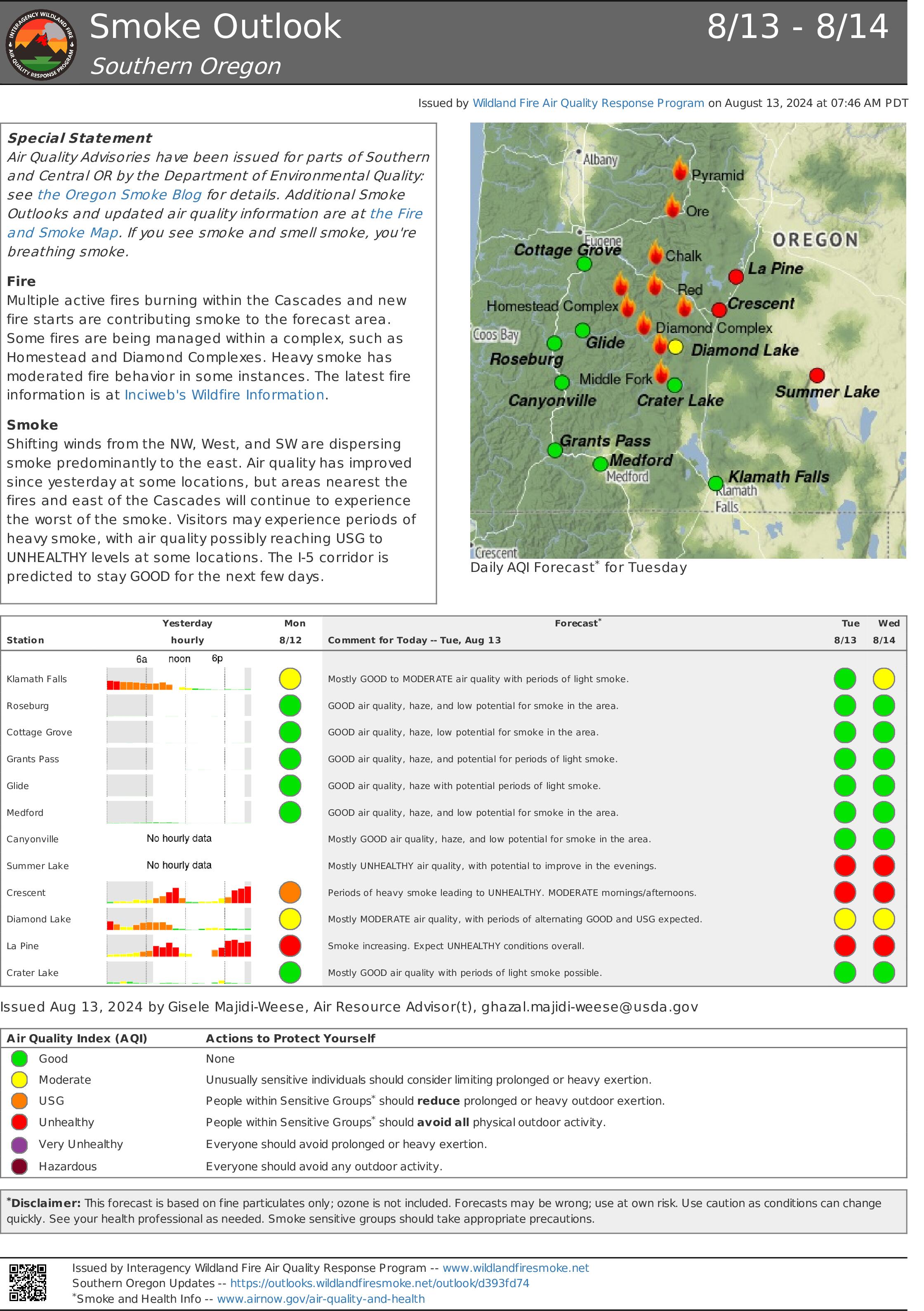
Smoke Outlook: https://outlooks.airfire.org/outlook/d393fd74
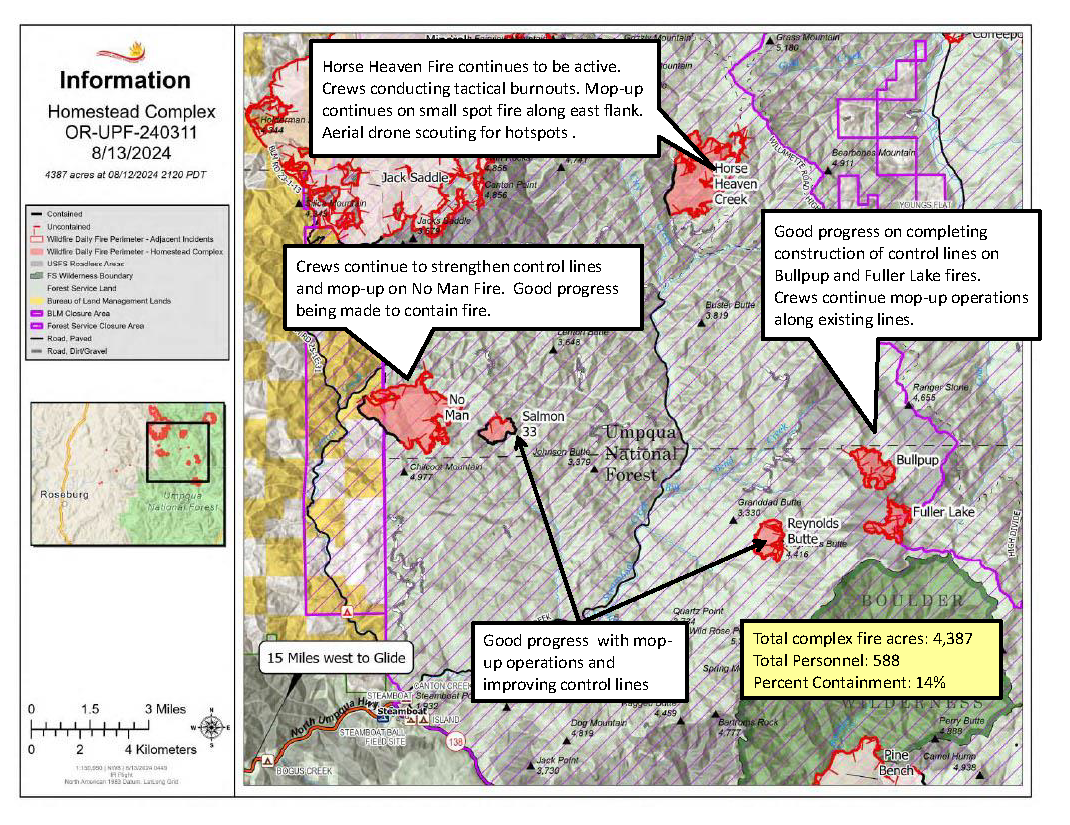
The Homestead Complex includes seven fires totaling 4,387 acres with an overall containment of 14%. There are 588 personnel currently working on the fire. Fire managers continue directing resources to fires based on threats to property, infrastructure, industry, and areas with the highest probability of success while providing for firefighter and public safety. The fire is being managed by Northwest Incident Management Team 8.
Yesterday, on the No Man Fire (1,660 acres), crews had good success with tactical firing operations inside established dozer line on the northern side of the fire, deepening the containment lines. Holding and mop-up efforts continued to progress. To the south, firefighters completed testing of the hoselays and prepared for today’s planned burnout, which will head west and north for several shifts. The Salmon 33 (244 ac.) Fire showed minimal movement and fire personnel focused on mop up and increased containment. Horse Heaven Creek Fire (1,369 ac.) continued to show growth to the east but did not push up against any lines. A hotshot crew scouted the area with a drone, and firefighters conducted burnouts in the northeast corner of the fire down the eastern flank from the 130 spur. On the southern side, the fire reached the 015 spur and was successfully held with engines and a skidgine. On both Fuller Lake (332 ac.) and Bullpup (413 ac.) fires, engines continued to hold the fires along the road systems while indirect line was constructed with heavy equipment. The Reynolds Butte Fire (335 ac) saw minimal activity and continues to be in great shape. Fire personnel were still engaged in mop-up work along containment lines.
Today on the No Man Fire, burnout operations will be the priority on the southern side of the fire as crews continue to build and improve containment line and prep roads. To the northern side of the fire, lines held overnight after yesterday’s tactical firing operations and firefighters will focus on mop-up today. Crews on the Salmon 33 Fire will be working on finishing indirect line to the west, and monitoring and mopping up around the footprint as minimal fire activity continues. On the Horse Heaven Creek Fire, crews will be tying in a two-acre spot on the east flank and then continuing yesterday’s burnout operations down from the 130 spur moving south. Drone scouting will continue in the north around the Windy Creek area, and contingency line construction is ongoing off the 5850 Road. The Bullpup and Fuller fires are holding on the east side, and crews will focus on mop up and solidifying their holds on the 5851 and 300 roads as fire continues to flank along them. Firefighters will scout north along both roads as well. The Reynolds Butte Fire remains close to patrol status. Crews continue to wrap up operations there and will be reallocated around the complex once work is complete. The Lost Bucket Fire (34 ac.) was contained on July 29 and remains in a patrol status.
Today’s weather: The marine layer did return overnight but didn’t entirely pass over the fire footprint. Relative humidity recovery was still good, in the 90-percent range. Temperatures will range in the 60s and 70s today and relative humidity should be in the 40-50 percent range, perhaps slightly lower than yesterday. Terrain-driven winds during the morning and noon hours will pick up at the higher elevations into the afternoon, with west-northwesterly gusts up to 20 mph possible. Temperatures should warm a little tomorrow.
Current forest fire restrictions and danger ratings are:
Fire Danger Rating: Very High
Industrial Fire Precaution Levels (IFPL): 3
Public Use Fire Restrictions (PUR): 3
CLOSURES:
The Bureau of Land Management (BLM), Roseburg District, has issued a closure order for portions of BLM land which border the Umpqua National Forest Emergency Fire Closure north of Steamboat. The closure order can be viewed here: https://www.blm.gov/sites/default/files/docs/2024-07/orwa-fpo-rbg-072624.pdf.
The Umpqua National Forest has Emergency Fire Closures in place impacting every district of the forest. https://www.fs.usda.gov/alerts/umpqua/alerts-notices.
Fire Prevention:
Continue to check for Fire Restrictions when recreating or working outside. Agencies use weather forecasts, the current regional and national fire situation, resource availability and many other factors to calculate appropriate fire restriction levels. Do your part to help keep unwanted human fire starts off of the landscape! #onlyyoucanpreventwildfires #itonlytakesonespark
Willamette Complex Daily Update for 08 13 2024
Related Incident: North Willamette Complex
Publication Type: News
Willamette Complex North
Ore & Pyramid Fires- incident Update
Date: Tuesday, August 13, 2024
Special Note
Tonight’s community meeting for the Willamette Complex North will be held at 6:00 p.m. at the Sweet Home Fire Station, located at 1099 Long Street, Sweet Home, OR. The Community Meeting will be livestreamed on YouTube and recorded.
CURRENT SITUATION
The Ore and Pyramid Fires continue to be managed for full suppression. As fire crews time out and travel home for much-needed rest and recovery, replacement crews are being ordered and continue to arrive.
Ore Fire
Blue River, 2,700 Acres, 15% Contained, 161 Total Personnel, Cause Under Investigation
Yesterday’s weather slowed planned firing operations, allowing crews the opportunity to patrol and reinforce existing fire lines. Crews observed minimal fire behavior and growth during overnight patrol. Today, crews on the northern flank will continue to evaluate firing opportunities, conducting burnout operations where weather conditions and fire behavior permit. Crews and heavy equipment on the western and eastern flanks will continue to prepare indirect fire line, patrol the perimeter, secure threats to the line by removing trees, snags and other fuels, and suppress any flare-ups or hot spots.
Pyramid Fire
East of Middle Santiam Wilderness, 1,324 Acres, 72% Contained, 300 Total Personnel, Lightning Caused
The established fire perimeter continues to hold, with pockets of intense and scattered heat across the fire. Today, crews will continue reinforcing and improving line, by mopping up and extinguishing hot spots.
Weather & FIre Behavior
A deep marine layer will continue to influence the fire, starting the day unusually cloudy and moist, with a low possibility of isolated drizzle. Predicted maximum temperature is 70 to 74 °F in the valleys and 66 to 70 °F on the ridgetops. Predicted minimum relative humidity is 46 to 52% in the valleys and 50 to 56% on the ridgetops. Even as weather moderates, heavy fuels continue to hold heat. Smoke and air quality conditions are available on: AirNow.gov
Evacuations, Closures & Fire Restrictions
On July 17th, the Linn County Sheriff’s Office, in coordination with the Willamette National Forest, issued a Level 3: Go Now Evacuation Alert for the closure area affected. Please refer to the Linn County Fire Map tinyurl.com/LinnCoFireMap for full details of the issued evacuation area (which will appear in red). To sign up for evacuation alerts, visit linnsheriff.org/.
Area, road, trail, and recreation site closures are in effect in the Willamette National Forest.
Specific information is posted at https://www.fs.usda.gov/alerts/willamette/alerts-notices/?aid=61574.
Fire restrictions are in effect for Willamette National Forest. Read the complete restrictions at: https://www.fs.usda.gov/alerts/willamette/alerts-notices/?aid=81487.
Wildfires are a no-fly zone for unauthorized aircraft, including drones. If you fly, we can’t.
For more information, visit http://knowbeforeyoufly.org.
2024 Borel Fire Daily Incident Update 08 13 2024
Related Incident: Borel Fire
Publication Type: News
Borel Fire Incident Update
Tuesday, August 13, 2024
Fire Information: 559-481-7849, 9 a.m. to 7 p.m.
Media Line: 559-492-9967, 9 a.m. to 7 p.m.
Email: 2024.borel@firenet.gov
Linktree: linktr.ee/2024sqflightning
Acres: 59,288
Containment: 91%
Total Personnel: 811
For more information on the Borel Fire, visit: https://inciweb.wildfire.gov/incident-information/casqf-borel-fire
A Local Assistance Center will be open today, August 13, 2024, providing
one last opportunity for residents of the Borel Fire from 10:00 am until 7:00 pm.
Address: Lake Isabella Senior Center, 6401 Lake Isabella Blvd. Lake Isabella, CA 93240.
Borel Fire: Crews continue to make progress with suppression repair work. Firefighters are still on high alert for potential new fires that start in the immediate area and are ready for a rapid response. Burned Area Emergency Response (BAER) teams have arrived and will begin to determine the need for and to prescribe and implement emergency treatments to stabilize and prevent unacceptable degradation to natural and cultural resources. We encourage residents re-entering the area to proceed with caution to avoid unseen hazards caused by the fire, and help maintain the safety of repair crews working in the area.
Trout and Long Fire: For continuing information, please visit:
https://inciweb.wildfire.gov/incident-information/casqf-2024-sqf-lightning
Weather: The fire area will see similar warm and dry conditions that continue to trend slightly cooler than the past weekend, with winds of 5-15 mph and gusts up to 25 mph.
Sequoia National Forest & BLM Closures & Restrictions: The Borel Fire Piute Mountains Area Closure begins at the northwest corner of Section 30, Township 27 South, Range 33 East, Mount Diablo Base and Meridian, then continues approximately 47 miles around the Sequoia National Forest Boundary to the starting point.. All orders, maps, and accompanying appendices can be found on the Forest’s website: tinyurl.com/2en2d36k. The Bureau of Land Management Bakersfield Field Office has temporarily closed Long Valley Campground, Chimney Creek Campground, and portions of the Pacific Crest Trail (PCT). View the emergency closure order here: tinyurl.com/4mprcb9b. The PCT is closed between Hwy 178 at Walker Pass (mile 653) and the South Fork of the Kern River bridge (mile 717.7).
Road Closures: All road closures associated with the Borel Fire have been lifted. Visit the Kern County Public Works Department website for the additional information on county road closures (tinyurl.com/z6crvp6t)
Evacuations: All Borel Fire evacuations have been lifted. Everyone in areas of active fires should “Know Your Zone.” Go to Genasys Protect (tinyurl.com/jcdv55f9) to identify the zone you reside in.
Middle Fork Complex Bulldog Nellie Anderson Daily Update 08 13 2024
Related Incident:
Publication Type: News
Incident Commander: Rick Connell, Northern Rockies Team 5
Middle Fork Complex Location: 9 miles east of Garden Valley, ID
Bulltrout Location: 15 miles WNW OF Stanley, ID Wapiti Location: 2 miles southwest of Grandjean, ID
Start Dates: 07/24/24 – 08/06/2024
Cause: Lightning
Size:
Bulltrout: 271 acres Wapiti: 2,667 acres
Middle Fork Complex: Bulldog: 2,100 acres Nellie: 3,681 acres
Containment: Middle Fork Complex: 0% Bulltrout: 92% Wapiti: 0%
Resources on site:
Middle Fork Complex: 1 hotshot crew; 5 type 2 hand crew; 9 engines; 3 bulldozers; 3 water tenders
Wapiti: 1 type 2 hand crew; 8 engines; 1 water tender
Bulltrout: 2 engines
Total Personnel: Middle Fork Complex: 300 Bulltrout:20 Wapiti: 57
KEY MESSAGE:
Join us for a Middle Fork Complex, Bulltrout, and Wapiti Fire Community Meeting Today at 7pm for an in-person explanation of current fire activity and planned actions on these fires. The Community Meeting will be located at the Lowman Emergency Services Station 80, at 8000 HWY 21, Lowman, ID. Also, the Boise National Forest adjusted the fire closure areas.
CURRENT STATUS/PLANNED ACTIONS:
Middle Fork Complex: The Middle Fork Complex is comprised of Bulldog, Nellie, and Anderson fires.
On the Bulldog Fire, strategic overnight firing operations along the south side of the fire were successful in connecting with the historic Pioneer fire burn area. Firefighters continue to secure the edge of the fire. On the north side of the fire crews are working with terrain and fuels to create a fuel break. The public is reminded that the Middle Fork Road is closed at the Forest Service boundary just south of Lightning Creek for firefighter and public safety as crews continue to work to protect private property and structures in the vicinity of Crouch.
On August 12th the Nellie and Anderson fires merged and will now be treated as one fire and retain the name Nellie. The current containment on the newly combined Nellie fire is 0%. The fire is burning in steep remote terrain and is backing into the 2016 Pioneer fire area. Crews plan to utilize unmanned aerial system (UAS) today to conduct strategic firing operations ahead of the fire to reduce fuels availability. The public is reminded that Forest Service Road #555 is closed at the intersection of Highway 17.
Wapiti Fire: Wapiti fire has been active in areas exposed to winds in upper elevations and ridges. Firefighters continue to ensure the structures in the vicinity of the fire are protected with improved defensible space, with an extensive sprinkler and water pumping system in communities near the fire. Crews are evaluating the Hanging Valley subdivision. Smoke may be visible from State Highway 21 please use caution while driving in the area. A predominant ridge on the west side of the fire is being assessed for opportunities to conduct strategic firing operations when conditions are favorable. On the south side of the fire is a historic fire area is adjacent to the fire and remains less receptive to fire activity.
Bulltrout Fire: The fire is 92% contained and firefighters continue suppression repair in areas affected by the fire. The fire is smoldering and creeping through unburned areas within the interior of the fire and crews continue patrolling and extinguishing pockets of heat in the interior of the fire on the south side of the fire.
WEATHER AND FIRE BEHAVIOR:
Yesterday the inversion lifted mid-afternoon as predicted, and the fires experienced west-southwest winds around 15 mph. Today a weak weather system is passing through the area and intermittent showers are expected and outflow winds may be possible. Thunderstorms in the morning will move out of the area around 1200 PM and conditions will remain cooler. An increase in fire activity is expected if outflow winds impact fire areas and when the sky clears. Fires are burning in timber and understory with group torching, spread will continue in all directions.
CLOSURES, RESTRICTIONS, AND EVACUATIONS:
Middle Fork Complex: The Boise County Sheriff's Office continues to maintain the Level 2 evacuation notice for residents on and near the Middlefork Road between Stump Ranch Road up to Tie Creek Campground. The Boise National Forest issued areas closure for the fire area (Closure #0402-06-59 and Closure # 0402-05-93). Effective August 12, 2024. The purpose of these orders is to protect public safety during the fires.
Wapiti Fire: The evacuation order for Summer Homes and the Sawtooth Lodge remain in effect for the Wapiti Fire, as does the area closure issued by the Sawtooth and Boise National Forests (Closure #0402-05-94) Effective August 12, 2024. This Order is for public and firefighter safety during fire suppression efforts of the Wapiti Fire.
Bulltrout Fire: The Bull Trout Fire Area Closure (Closure #0402-05-93) remains in effect for the roads, trails within the perimeter of the fire. Boise National Forest issued this order on August,12, 2024. It will be rescinded as soon as it is safe to do so.
Closure information and maps are posted on the Forests’ website and the fire’s Inciweb page as they are in place. https://tinyurl.com/2u8v3pf7
The Boise National Forest, Idaho Department of Lands, and Bureau of Land Management are in Stage 1 fire restrictions on state, endowment, private and federal lands within the West Central Mountains Fire Restrictions Zone. For more information on the restrictions and a map visit:
https://www.idl.idaho.gov/fire-management/fire-restrictions-finder/
Falls and Telephone Fires Update for Aug 13 2024 08 13 2024
Related Incident: Falls FireTelephone Fire
Publication Type: News
Falls and Telephone Fires Update for August 13, 2024
Telephone Fire Quick Facts:
Size: 53,989 Start Date: July 22, 2024 Location: 12 miles NE of Burns, OR
Containment: 64% Cause: Lightning/Natural
Falls Fire Quick Facts:
Size: 151,399 Start Date: July 10, 2024 Location: 13 Miles NW of Burns, OR
Containment: 87% Cause: Human-caused, under investigation
Structures Triaged: Residences: 386 / Commercial: 119 / Outbuildings: 760
Sand Mountain Fire Quick Facts:
Size: 7,582 Start Date: July 25, 2024 Location: 17 miles SW of Seneca, OR
Containment: 92% Cause: Lightning/Natural
Total Personnel Across all fires: 1135
Total Resources Assigned: 30 hand crews, 48 engines, 14 bulldozers, 31 water tenders, 1 masticator, 12 skidgines
Aerial resources assigned: One Type 1 helicopter
Post-fire Recovery Meeting, hosted by OSU Extension Office: Tonight, August 13, 7:00 p.m. at the Harney County Chamber of Commerce. Learn about resources available for residents, landowners, livestock, and agricultural operations impacted by the Falls and Telephone Fires. This meeting will be recorded and shared on the Falls and Telephone Fires Facebook page.
Priorities for Monday August 12
- 1) Initial Attack (IA) is the highest priority to keep all new fires as small as possible.
- 2) West side of the Telephone Fire/King Mountain area.
- 3) Northeast portion of the Falls Fire near Myrtle Creek.
Telephone Fire: Yesterday, firefighters continued securing the fire edge along the 2820 Road east of Coffeepot Creek and worked aggressively to keep fire west of the 28 Road. Additionally, ranchers, firefighters and cooperators worked together to drive cattle south along the 28 Road to safer, unburned areas for grazing. Other portions of the fire were monitored and patrolled. Today, work to construct a shaded fuel break on the 2830 and 28 Roads will be nearing completion. Firefighters in the southwest and west will be cleaning up pockets and conducting burn operations to remove unburned fuels that contribute to continued fire activity. The eastern side of the fire is being monitored and patrolled.
Falls/Sand Mountain Fires: Yesterday, crews continued to contain fire near the 31 Road northeast of Crane Flats and worked to remove hazardous trees called snags in the northeast portion of the fire. Crews also strengthened containment lines and monitored earlier fire spread near Myrtle Creek. Today, crews will work on backhaul on the west side of the fire. Backhaul—the process of returning equipment and supplies on a wildfire to a central point for redistribution—is an essential part of wildfire logistics and ensures that resources are efficiently managed and available for changing fire conditions or future incidents. Firefighters in the northeast will focus on clearing out small pockets, conducting burn operations to remove unburned fuels that contribute to fire activity, and continuing felling operations to remove hazardous trees. With increased containment across the fire, more of the perimeter is in patrol and monitor status.
Weather: Overnight, most of the area received some rain and a large number of cloud-to-ground lightning strikes occurred east of Highway 395. Today, anticipate moderate and stable conditions, with breezy winds and low relative humidity. Temperatures are expected to be cooler than yesterday, accompanied by clear skies and a slight chance of thunderstorms. Looking ahead, moderate conditions will persist on Wednesday with calmer winds. Thunderstorm activity is likely to return on Thursday.
Evacuations: There are no changes to the evacuation orders for Grant and Harney Counties. For the most accurate evacuation information, visit the Harney County Sheriff’s evacuation map: https://bit.ly/FallsFireEvac, or the Grant County Emergency Management Facebook page: https://www.facebook.com/profile.php?id=100068819321423
Closures: A closure is in effect for portions of the Malheur National Forest west of 395B, north of Mt. Vernon and south of Long Creek, in the Fox Valley area, including all roads, trails, and camping. A closure map is available on the Malheur National Forest website (https://www.fs.usda.gov/detail/malheur/news-events/?cid=FSEPRD1198892) and in local U.S. Forest Service offices.
Investigation: The U.S. Forest Service is seeking the public’s assistance with any information pertinent to the start of the Falls Fire on the Malheur National Forest. Submit any relevant information to SM.FS.R6TipHotLine@usda.gov.
Temporary Flight Restriction (TFR): TFRs in the area have been changing; pilots should check the latest information on the Federal Aviation Administration TFR website prior to flying: https://tfr.faa.gov/tfr_map_ims/html/index.html
Facebook: https://www.facebook.com/p/Falls-Fire-2024-61562126623985/
Falls Fire InciWeb: https://inciweb.wildfire.gov/incident-information/ormaf-falls-fire
Telephone Fire InciWeb: https://inciweb.wildfire.gov/incident-information/ormaf-telephone-fire
Fire Information Line: 541-208-4370, staffed 8 a.m. to 8 p.m. Email: 2024.Falls@firenet.gov
Harney County Non-emergency Evacuation Questions: 541-589-5579
Air Quality Questions: 541-573-2271. Air quality information, searchable by zip code: https://fire.airnow.gov/
Smoke Outlooks: https://outlooks.airfire.org/outlook
Cougar Creek Fire Update 08 13 2024
Related Incident: Cougar Creek Fire
Publication Type: News
Cougar Creek Fire Update for August 13, 2024
Complex Incident Management Team Northwest 12
509-210-2928, staffed 8 a.m. to 6 p.m.
Quick Facts:
Size: 24,096 Acres
Start Date: July 15, 2024
Cause: Under investigation
Location: SW of Clarkston, 1 mile west of Hwy 129 and Grand Ronde River intersection
Containment: 60%
Personnel: 380
Fire Strategy: Full suppression
Resources Assigned: 6 crews, 3 helicopters, 28 engines, 11 water tenders, 6 heavy equipment
The Cougar Creek Fire is burning within a mountainous and remote area on the Umatilla National Forest bordering the Wenaha-Tucannon Wilderness.
Today is Northwest Team 12’s last day on the Cougar Creek Fire. Fire management will transition to Northeast Washington Team 1 at 7 PM tonight. Northwest Team 12 would like to thank the community for your support and for hosting our team at Heights Elementary and Lincoln Middle Schools and over the past two weeks. With the school year starting soon, the incoming team will be based at the fire camp near Fields Spring State Park.
Operations: Yesterday firefighters used the aerial UAS platform with a plastic sphere dispenser (PSD) to finish firing gaps on the north side of the fire along FSR 43; the mosaic pattern of vegetation made some of these areas resistant to firing operations. There was a small slop over fire in debris from a dozer line across FSR 40 near Saddle Butte yesterday; firefighters quickly lined the slop over fire and remained vigilant in their mop up work on the fire perimeter. Fire crews continue to patrol around the fire and mop up near containment lines. The masticator and grader are completing repair work and debris removal on FSR 4039.
Today firefighters continue to backhaul excess equipment and remove remaining hose from the line. Given the widespread rain across the fire area this morning, firefighters will be cautious on muddy roads around the fire and will focus on completing mop up as needed.
Evacuations and Closures: All level 1, 2 and 3 evacuations for the Cougar Creek Fire were removed yesterday. The Grand Ronde Road has fully reopened in both Oregon and Washington. Forest closure descriptions and maps are available online on the Umatilla National Forest closure website. In Washington, evacuation notices are posted on the Asotin County Sheriff website and Asotin County Emergency Management Facebook website. The TFR over the fire remains in effect: https://bit.ly/4duptei. Drone activity is prohibited under the TFR as firefighting aircraft cannot fly with unauthorized drones present. Please respect road and area closure orders and use extra caution while driving for your safety as well as our firefighters.
Weather and Smoke: A series of weather disturbances will move through the region this week, with a slight chance of rain occurring this morning across the fire area. Passing thunderstorm cells with lightning were observed this morning at the fire base camp and Incident Command Post. Air quality in the region is good today. Learn more about smoke at http://wasmoke.blogspot.com/.