
Community Meeting in Cascade Idaho tonight Tuesday August 13 at 7 pm 08 13 2024
Related Incident: Wolf Creek FireBoulder FireDollar Fire
Publication Type: News
***ATTENTION***
The Great Basin Complex Incident Management Team 2 will host an in-person community meeting on the #Westmountaincomplex fires in Cascade, Idaho on Tuesday, August 13 at 7 p.m.
The meeting will be held at the Cascade Fire Department at 109 E Pine St. There is ample parking available.
The meeting will present information on the Snag, Wolf Creek, Boulder, Dollar, and Goat fires and answer public questions.
The meeting will be available for viewing.
For additional information on these fires:
https://inciweb.wildfire.gov/incident.../idbof-snag-fire
https://inciweb.wildfire.gov/incide.../idpaf-wolf-creek-fire
https://inciweb.wildfire.gov/incident.../idbof-boulder-fire
Boise Fire August 13 Update 700 am 08 13 2024
Related Incident: 2024 Boise Fire
Publication Type: News
Leader’s Intent: The Boise Fire is being managed with a full suppression strategy.
Operational Update: Last night’s firing operations were successful and crews got good depth along Forest Road 10N01 toward the fire’s edge to meet constructed dozerline. This tactic is being deployed to protect the structures at Le Perron Flat should the fire make a run toward the northwest. Crews are working a swing shift from noon to 2:00 a.m. to accomplish this mission, and it is likely to continue tonight if conditions allow.
Priorities today remain the same as yesterday, with crews focusing on constructing and improving lines along the road systems on the west and southwest edges of the fire, to protect Short Ranch and the inholdings around Le Perron Flat, and to look for opportunities to check the fires spread to the east. The current operational objective is to hold the fire west of Antennae Ridge/ Orleans Lookout Road.
Weather and Fire Behavior: Today’s weather is expected to be similar to yesterday, with lower daytime temperatures and good overnight humidity recoveries. A deepening marine layer is anticipated to push into the area over the next few days, accompanied by cooler temperatures and higher humidity. Firefighters will take advantage of these cooler and moister conditions to continue operations on the ground. Aircraft use may be limited by visibility, especially during the morning hours.
###
Daily Update on Clearwater Fire for Tuesday 08 13 2024
Related Incident:
Publication Type: News
Fire Location: 11 miles west of Wapiti, WY
Size: 1,896 acres
Containment: 62%
Personnel: 80
Start Date: 7/19/24
Cause: Lightning
Incident Commander (IC): Ron Steffens, Wyoming Type 3 Team
Operations
Cooler temperatures and some light rain within the fire area have allowed for containment to increase to 62%. Yesterday, fire crews continued cleaning up brush and downed trees in the Elk Fork Campground and patrolled fire lines.
Today, crews will watch the highway and river corridor for any fire movement closer to the perimeter. The fire is likely to burn and smolder for some time in heavy fuels and steeper terrain. Expected rain may decrease activity in the fire’s interior over the next few days, but the potential for fire spread will return as conditions change. Firefighters will monitor the effects of the current short-term weather pattern while preparing for critical fire weather conditions that much of the region is experiencing. Fire managers will base their actions on a number of factors including public and firefighter safety, complexity, fire behavior, and weather.
Closures
Elk Fork Campground is closed indefinitely for the season; Wapiti Campground and Clearwater Campground remain closed until fire conditions allow otherwise. A road and trail closure are in effect at NFS Road #424, Elk Fork Road and NFS Trail # 760, Elk Fork Trail. Click here to view the closure order (#021404-24-03). For safety reasons, the public is asked to respect closed campgrounds and trails. A temporary flight restriction (TFR) is in effect until August 19, 2024.
Weather | Anticipated Fire Behavior
Today’s forecast calls for a chance of rain showers and thunderstorms throughout the day. This could produce gusty and erratic winds which could affect fire behavior and growth.
Safety Information - The Shoshone National Forest implemented Stage 1 fire restrictions due to very dry conditions of fuels and continued hot, dry weather. Click here to view a copy of Stage 1 Fire Restrictions order (#02-14-04-24-04).
Dixon Fire Evening Update 8122024 08 13 2024
Related Incident: Dixon Fire
Publication Type: News
Aerial Assets Assist Suppression Efforts on Dixon Fire
Days Creek, Ore. – Today, firefighters took advantage of cooler morning temperatures to engage with the fire and continued to establish control line. In the afternoon, fire activity increased substantially, and air assets were heavily utilized to assist with suppression. Structure resources provided point protection on several properties due to fuels burning in the area. Due to increased fire activity, additional crews were moved up the FSRD 1610 and along the 100-spur road, including the repositioning of the structure group positioned in Drew.
Tomorrow, plans are in place to start removing hazardous trees along the Tiller Trail Highway. There may be extended delays between milepost 26 (junction of South Umpqua Road and Tiller Trail Highway) and milepost 32 (near the community of Drew). Please use caution when entering this area.
Evacuations:
Evacuation levels are managed by the Douglas County Sheriff and were updated this morning. Please stay up to date here: https://www.dcso.com/270/Evacuations
The new official Red Cross shelter is now at:
Days Creek Charter School
11381 Tiller Trail Hwy Days Creek, OR 97429
Closures:
Forest service closure - Please see the following links: Order: https://www.fs.usda.gov/Internet/FSE_DOCUMENTS/fseprd1200029.pdf Map: https://www.fs.usda.gov/Internet/FSE_DOCUMENTS/fseprd1200030.pdf
Smoke outlook
A smoke condition warning has been issued for the immediate area.
For updates check: https://fire.airnow.gov/#
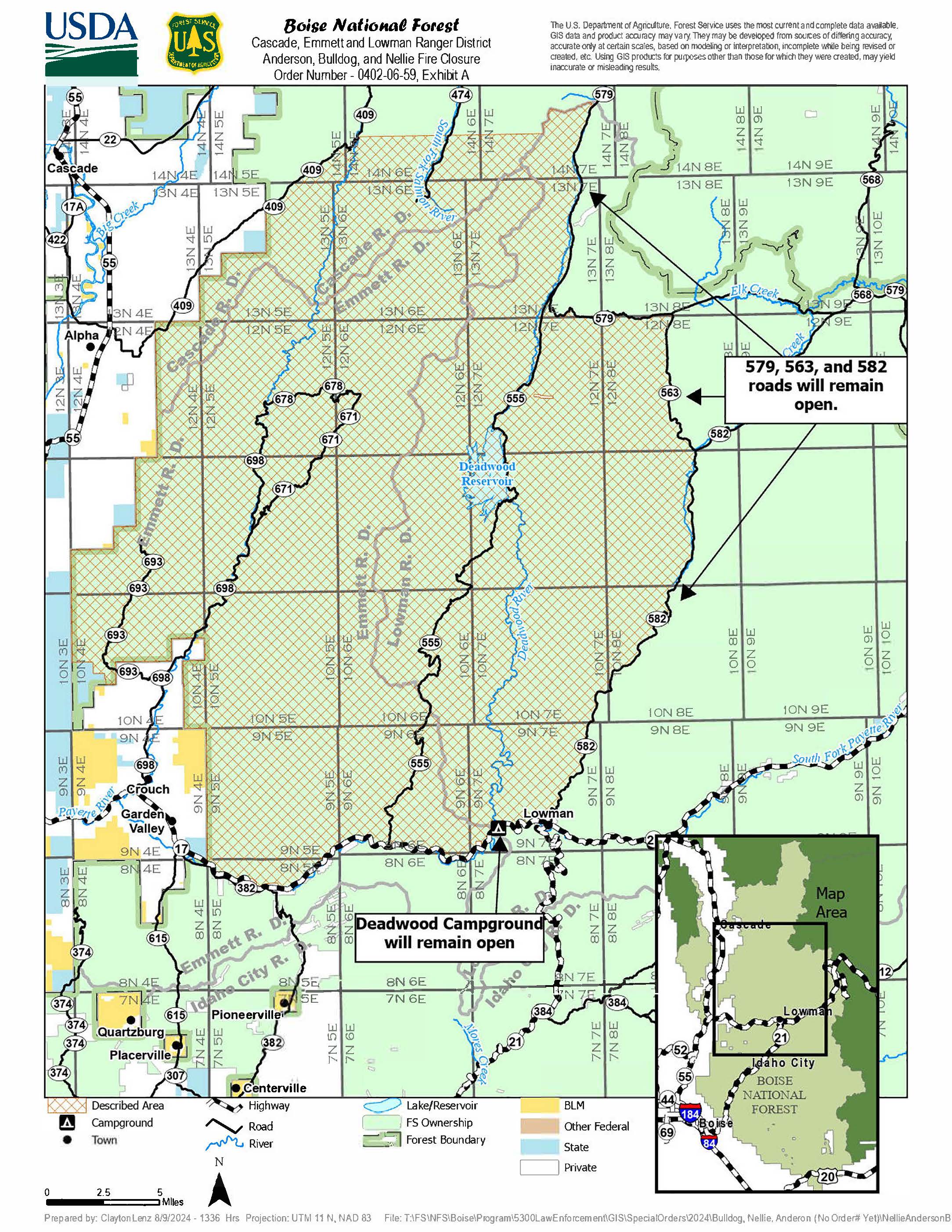
Closure Order Anderson Bulldog and Nellie Combined Fires 08 13 2024
Related Incident:
Publication Type: Closures
BOISE, Idaho, Aug. 12, 2024 – The Boise National Forest has modified or expanding their wildfire closures to address public and firefighter safety and respond to increased wildfire growth. Changes became effective earlier today.
Please refer to the maps and closure orders on the Boise National Forest’s Alerts and Notices webpage and Interactive Forest Closure Map for specific details.
This new closure includes and expands upon the existing Bulldog and Anderson/Nellie Closure Order, and now includes an area around the Goat Fire, located two miles southeast of East Mountain.
This new closure area begins at the south end of the Dollar/Oro (Snag) fire closure area and continues south to Crouch and the Banks-Lowman Hwy, and east to the 579, 563 and 582 roads.
The 579, 563 and 582 roads will remain open, but all roads, trails and campgrounds within the closure area, include Deadwood Reservoir, are closed. An exception is the Deadwood Campground, located along the north side of the Banks-Lowman Hwy, will remain open.
Monday Evening Update for the Park Fire 08 12 2024
Related Incident: Park Fire
Publication Type: News
Evening of Monday, August 12, 2024
For more information on the Park Fire, please visit: https://inciweb.wildfire.gov/incident-information/calnf-park-fire
Size: 429,263 acres with 39% containment | Personnel: 5,638
Lassen National Forest:
The ongoing work of firefighters on the ground, with support from tactical aviation resources, has kept the Park Fire within its existing footprint. There was no new growth on the Park Fire and any remaining heat within the fire’s edge continues to be eliminated through the firefighters’ effort to remove or extinguish all burning or smoldering material along containment lines. Crew sand heavy equipment have also worked to remove hazardous trees along roadways and the fire perimeter, and continue with suppression repair efforts, or returning the disturbed areas to as natural a state as possible.
Smoke will be visible in the area as unburned fuels within the fire perimeter are consumed.
Overnight, firefighters will strengthen fire lines and patrol the fire perimeter with supported from infrared data showing areas of heat from Unmanned Aircraft Systems (UAS).
The #ParkFire has burned 113,736 acres on the Lassen National Forest.
CAL FIRE:
The fire held within its current perimeter today despite stronger winds throughout the day. The fire is primarily burning in mature timber with dead and down fuels being the primary driver and interior islands continue to burn within the perimeter.
Cooler, higher humidity and less wind will have a favorable impact on fuels in the lower elevations. Suppression efforts continue throughout the fire from both ground and air support.
For more information on the Park Fire please visit:
- CALFIRE Park Fire: https://www.fire.ca.gov/incidents/2024/7/24/park-fire
- CAL FIRE Shasta-Trinity Unit/Shasta County Fire Department: https://www.facebook.com/CALFIRESHU
- CAL FIRE Tehama-Glenn Unit/ Tehama County Fire Dept: https://www.facebook.com/CALFIRETGU
- Butte County, CA: https://www.facebook.com/ButteCounty
- Butte County Sheriff: https://www.facebook.com/bcsonews
- Plumas County Sheriff: https://www.facebook.com/plumascountysheriff
- Shasta County Sheriff: https://www.facebook.com/ShastaSheriff
- Tehama County Sheriff: https://www.facebook.com/profile.php?id=100088640404140
Closure of the Tiller Ranger District of the Umpqua National Forest 08 12 2024
Related Incident: Dixon Fire
Publication Type: Closures
Effective immediately, Closure ORDER NO. 06-15-02-24-02 has gone into effect today, Monday, August 12, 2024, on the Tiller Ranger District of the Umpqua National Forest in response to the Dixon Fire. The following acts are prohibited upon trails and general forest areas within the Umpqua National Forest as described below and shown in Exhibit A (pictured). This Order is effective beginning August 12, 2024, and ending January 15, 2025, unless rescinded sooner.
PROHIBITIONS:
1. Being on the road. [36 CFR § 261.54 (e)]
2. Going into or being upon an area for the protection of public health and safety. [36 CFR § 261.52 (e)]
3. Being on a trail. [36 CFR § 261.55(a)]
The fire closure is described as an area starting at T30S, R2W, Sec. 33 at the intersection of Hwy 1 Tiller Trail Highway and the Umpqua NF Proclamation Boundary Northwest of the Tiller Ranger Station, following the Umpqua NF Boundary Northeast to the intersection of Hwy 46, following Hwy 46 Northeast to Forest Service Road (FSR) 29, following FSR 29 to the Intersection of FSR 3100, following FSR 3100 South to FSR 1610, following FSR 1610 South to the Umpqua NF Proclamation Boundary, following the Umpqua NF Proclamation Boundary Southwest to Hwy 1 Tiller Trail Highway, following Hwy 1 Tiller Trail Highway back to the point of origin. FSR 29 will remain open. FSR 3100 and FSR 1610 are closed where used as closure area boundaries.
The status of roads, lands, and trails not under Umpqua National Forest jurisdiction will be determined by the corresponding agency or government entity. Hwy 46 and Hwy 1 are under the jurisdiction of Douglas County. Evacuations due to the Dixon Fire are managed by the Douglas County Sheriff: https://www.dcso.com/EVACUATIONS
For more information on the Dixon Fire please visit Dixon Fire 2024
A map of the closure ORDER NO. 06-15-02-24-02 can be found below. A PDF version of this map can be found, here: https://www.fs.usda.gov/.../FSE_DOCUMENTS/fseprd1200030.pdf
To read the signed closure order, visit: https://www.fs.usda.gov/.../FSE_DOCUMENTS/fseprd1200029.pdf
Dixon Fire Morning Update 8122024 08 12 2024
Related Incident: Dixon Fire
Publication Type: News
Moderate Temperatures Support Progress on the Dixon Fire
Days Creek, Ore. - Firefighters on the Dixon Fire worked through the night to extend control lines around the fire perimeter. The fire is currently 1833 acres and is 0% contained. The combination of erratic wind and dry fuels have driven fire growth and produced active fire behavior, including some spotting.
Temperatures and humidity are expected to moderate today, which should result in reduced fire activity and present increased opportunities for firefighters to engage with the fire.
The Oregon Department of Forestry Incident Management Team 2 (ODF Team 2) and Oregon State Fire Marshal (OSFM) Green Team assumed unified command of the fire today, August 12th, at 6am. The focus for day shift will be to keep the fire within its current footprint, strengthen control lines and mitigate hazards along the Tiller Trail Highway.
Dedicated crews will be working to address snags and hazardous debris along Tiller Trail Highway to reopen this essential roadway as soon as possible. On the northern edge of the fire, crews will continue to increase holding on handlines, address spot fires and conduct mop up. Throughout the eastern and southern edges, resources will be constructing additional direct and indirect line, as well as tying existing portions of fire line together. Multiple air assets will continue to engage with the fire to support suppression efforts.
Structure resources have completed surveys on most structures immediately adjacent to the fire and have been actively engaged with fire along FSRD 1610. Today, these task forces will continue to mop up and patrol along FSRD 3113, as well as 1610 and the 100-spur road. Structure groups will also be working around Drew to establish contingency plans.
There are no current changes to the evacuation levels. Conflicting reports have been shared by users on social media regarding the number of structures affected. The Douglas County Sheriff’s Office is always your up-to-date and accurate source for evacuation information.
The official Red Cross shelter is at • Canyonville School, 124 Main St. Canyonville, Oregon. When unstaffed, the shelter will have a phone number listed for those needing access.
Closures: There is a hard road closure in place on Tiller Trail Highway between South Umpqua and Devils Knob due to fire impacts.
Smoke outlook
A smoke condition warning has been issued for the immediate area.
For updates check: https://fire.airnow.gov/#
2024 SQF Lightning Daily Incident Update 08 12 2024
Related Incident: 2024 SQF Lightning
Publication Type: News
Fire Information: 917-921-5226, 8 a.m. to 8 p.m.
Media Line: 917-921-5226, 8 a.m. to 8 p.m.
Email: 2024.lightning@firenet.gov
Inciweb Fire Info: https://inciweb.wildfire.gov/incident-information/casqf-2024-sqf-lightning
Trout Fire: Crews will continue to improve, patrol, and monitor fire lines along eastern and southern flanks of the fire. Transition to damage assessment and suppression repair continues with a group being established to focus on these efforts where needed across both fires. Excess hose and equipment are being inventoried and backhauled. All crews have been extracted in steep country where there will be continued monitoring by air. The fire is burning in sparse fuels under timber understory. With the forecasted weather the fire will struggle to reach the indirect line for the next several days.
Long Fire: Fire activity remains minimal with containment at 98 percent. No forward fire progression is expected. The Long fire is being monitored by air. Suppression repair work was completed in the Kennedy Meadows area and grading operations have concluded on Canebrake Rd.
Weather & Air Quality: A trough moving through central California will lead to an increase in winds along with a decrease in temperatures through mid-week. Continued low relative humidity (RH) due to a dry airmass moving into the region. Max temperatures of 70-80 degrees are expected today with a RH of 18-27%. West to west/northwest wind speeds of 15-25 mph with gusts of 35 mph are expected after 3pm. On ridges/exposed areas wind speeds of 20-30 mph with gusts of 45 mph are expected. Tonight, minimum temps across the fire will range from 43-57 degrees with RH recoveries between 28-69 percent.
Sequoia National Forest & BLM Closures & Restrictions: Sequoia National Forest lands, roads, trails, and recreation sites around the Trout and Long Fires are temporarily closed under Forest Order No. 0513-24-13. All orders, maps, and accompanying appendices can be found on the Forest's website. The Bureau of Land Management Bakersfield Field Office has temporarily closed Long Valley Campground, Chimney Creek Campground, and portions of the Pacific Crest Trail (PCT). The PCT is closed between Hwy 178 at Walker Pass (mile 653) and the South Fork of the Kern River bridge (mile 717.7).
Evacuation Center: The Tehachapi Education Center (126 S. Snyder Ave., Tehachapi) has been placed in a standby status, due to no residents currently utilizing the service. Contact the American Red Cross at 1-800-733-2767.
Large-Animal Assistance:
The rodeo grounds in Kernville (467 Scodie Ave., Kernville) is available for residents who need to move large animals or livestock. For more information, contact Orion, Kernville Chamber of Commerce, 661-340-0026.
Road Closures: The Trout Fire Closure Area boundary begins at the intersection of the Sequoia National Forest Boundary and Sierra Way (Mtn 99) in Section 14, Township 25 South, Range 33 East, Mount Diablo Base & Meridian, then continues approximately 76.5 miles south, east, north, and west along the Forest Boundary to its intersection with the North Fork of the Kern River in Section 1, T. 20 S., R. 34 E., MDB&M, then continues along Mtn 99 approximately 20.3 miles to the starting point. Visit the Forest Service Forest Orders and Forest Regulations website for more info on closures in the Sequoia National Forest.
Evacuations: Currently, Tulare County has no evacuation warnings or advisories in effect. Everyone in areas of active fires should “Know Your Zone.” Go to Genasys Protect to identify the zone you reside in.
Canyon Fire Evening Update 08 12 2024
Related Incident: Canyon Fire
Publication Type: News
Crews continue to improve and patrol containment lines while putting out hot spots that could allow the fire to cross the line. Repair to areas damaged by suppression efforts also continues.
The steep terrain within the Tuolumne River Canyon, the southern exposure crews are working on, and the hot and dry weather are the most difficult challenges for firefighters.