
Actualizacin Matutina del Incendio Retreat 13 de Agosto 08 13 2024
Related Incident: Retreat
Publication Type: News
Actualización Matutina del Incendio Retreat - 13 de Agosto
Información sobre incendios: 509-213-4890, de 8 a.m. a 8 p.m.
Correo electrónico 2024.Retreat@firenet.gov
Linktree: linktr.ee/CIIMT14
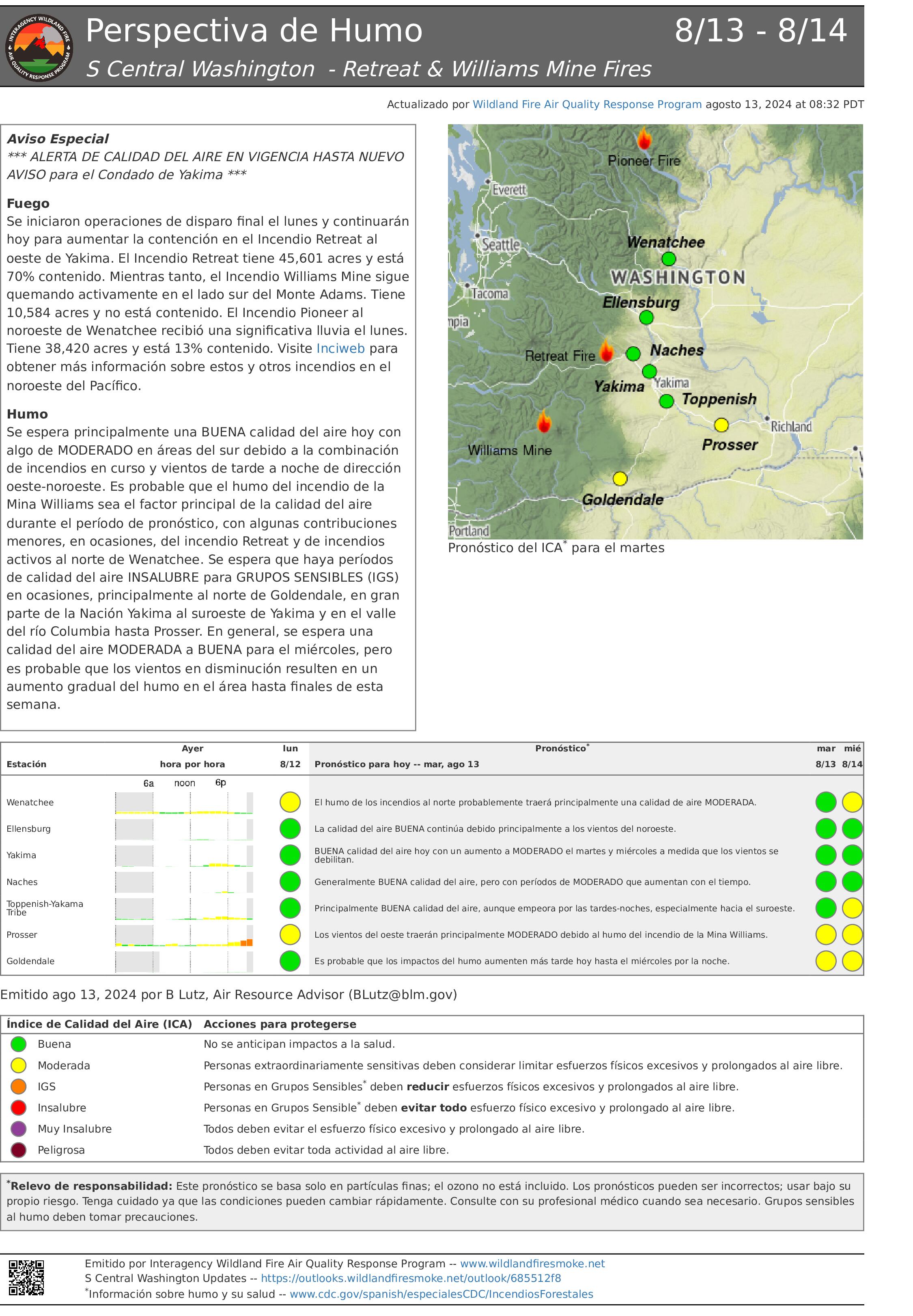
Acres totales: 45.601 acres
Contención: 70%
Cantidad de personal: 343
Situación actual: Ayer, los bomberos tuvieron éxito con las operaciones de fuego táctico a lo largo del flanco occidental al sur de Bethel Ridge. Estos trabajos continuarán mientras el tiempo lo permita. Durante un vuelo de reconocimiento aéreo se detectaron puntos calientes y humo que estaban limitados y en su mayoría interiores, en toda la zona del incendio.
Hoy, los bomberos dedicarán un esfuerzo adicional a evaluar los árboles que puedan haber sufrido daños y puedan caer en su zona de trabajo antes de continuar con las operaciones de limpieza. Las cuadrillas patrullarán las zonas de Camp Ghormley, Lost Lake Road y el corredor de la autopista 12, y trabajarán para completar una línea de control alternativa (cortafuegos sombreado) a lo largo de las carreteras forestales 1200 y 1201 para proteger las estructuras en la zona de Rimrock Lake. Los bomberos han comenzado a retirar los equipos y mangueras innecesarios de la línea de fuego y están comenzando la reparación de la extinción del incendio (nivelación de carreteras, tala de árboles peligrosos y reparación de la línea de dozer) donde confían en que el incendio está totalmente contenido.
A lo largo de la carretera estatal 12, las cuadrillas están trabajando para eliminar los árboles peligrosos que representan una amenaza tanto para los bomberos como para el público. La eliminación de estos peligros, así como la reparación de los daños en las infraestructuras (postes de guardarraíles quemados, etc.), a lo largo de esta autopista sigue siendo una prioridad absoluta para que esta ruta pueda abrirse y se levanten las órdenes de evacuación lo antes posible.
El incendio de Retreat se está gestionando con una estrategia de supresión total, dando prioridad a la seguridad pública y de los bomberos.
Tiempo: El viento consistente del noroeste seguirá trayendo aire fresco/húmedo desde la costa. Los vientos serán más fuertes por la mañana y por la noche, con rachas de hasta 24 mph. Las humedades mínimas serán del 30-40%, lo que supone un aumento del 9-10% respecto a días anteriores. Las temperaturas en la zona del incendio serán de unos 60 grados.
Evacuaciones: Para obtener la información más actualizada sobre evacuaciones, visite el sitio web de Administración de Emergencias del Condado de Yakima en yakimacounty.us/350.
Cierres por incendio:
- La US Highway 12 permanece cerrada entre la Y de la Highway 410 y la cima del puerto en el punto kilométrico 151.
- Okanogan-Wenatchee National Forest Retreat Fire Closure(tinyurl.com/5ext5aec).
- La Región Sureste del Departamento de Recursos Naturales del Estado de Washington (DNR) ha cerrado temporalmente parte del Bosque Estatal de Ahtanum. El público puede acceder a la información más actualizada sobre el cierre en dnr.wa.gov/ahtanum.
- El Departamento de Pesca y Vida Silvestre de Washington ha cerrado al acceso público la mayor parte de la zona silvestre de Oak Creek debido al incendio Retreat Fire hasta el 23 de agosto de 2024. Más información en tinyurl.com/bdet7845.
Calidad del aire y humo: En airnow.gov puede consultar las previsiones sobre la calidad del aire y el humo.
Crazy Creek Fire Daily Update for August 13 2024 08 13 2024
Related Incident: Crazy Creek
Publication Type: News
Cooling temperatures and higher humidities improve conditions for containment
Daily Update August 13, 2024
Fire Information Phone: 541-208-1768 (8 a.m.-8 p.m.)
Email: 2024.crazycreek@firenet.gov
Acres*: Crazy Creek – 86,603; 60% contained Kitty Creek – 73; 100% contained
*Acreage changes may occur due to overnight operations and infrared mapping.
Location: Crazy Creek: 5 miles north of Paulina, Oregon; 498/Kitty Creek: 7 miles south of Mitchell, Oregon
Start Date: July 22, 2024 Personnel: 739
Resources: 20 crews | 1 helicopter | 39 engines | 12 bulldozers | 19 water tenders | 3 masticators | 37 skid steers
Highlights: On Monday, interior pockets of fuel continued to burn within the Crazy Creek Fire though the fire perimeter continues to remain the same. The Crazy Creek Fire increased by 2,091 acres burned to 86,603 total acres. Firefighters successfully held problem areas in check. The fire is now 63 percent contained.
Changing weather conditions such as slightly cooler temperatures and slightly higher relative humidities created improved conditions for containment yesterday. This trend is expected to continue for the next several days.
Firing operations and yesterday’s increased fire activity accomplished a lot in reducing the size of the interior islands. The fire activity is active along the northeast side of the fire in Little Summit, Wolf, and East Wolf Creek. Active fire behavior is expected to continue over the next several days with potential spotting over containment lines. Firefighters will continue to patrol for the threat of spot fires outside of control lines.
An overnight flyover of the Kitty Creek Fire confirmed that it is out.
Evacuations: Crook County Sherriff’s Office has lowered the evacuation level to Level 2 for the area of Highway 380 north to SE Puett Road. The area north of SE Puett Road around the perimeter of the fire is still at Level 3. The area south of Highway 380 is now lowered to Level 1. Please review the Crook County Office of Emergency Management evacuation map for further details.
Weather: Slightly cooler weather is forecasted over the next couple of days with high temperatures in the 80s, low relative humidities, partly cloudy skies, and light wind gusts of up to 20 mph in the afternoon.
Importance of Fire Prevention: All public lands in Central Oregon, including the Ochoco National Forest, are in Stage 2 Public Use (Fire) Restrictions. All open flames, including woodstoves and charcoal briquette fires, are prohibited. In times of high fire danger, it is crucial for everyone to follow prevention measures to avoid additional strain on overburdened resources.
Fire Restrictions and Closures: The Ochoco National Forest has implemented a forest closure for the Paulina Ranger District. The Bureau of Land Management has issued a temporary closure for public lands in Crook and Grant Counties.
More Information:
InciWeb: https://inciweb.wildfire.gov/incident-information/orocf-crazy-creek
Facebook: Facebook.com/Crazy Creek Fire
Central Oregon Wildfire Information: https://centraloregonfire.org/
Crook County Emergency Information Map: https://arcg.is/1ij0vb
Whisky Creek and Sandstone Fire Daily Update 08 13 2024
Related Incident: Whisky Creek FireSandstone Fire
Publication Type: News
Whisky Creek:
Size: 1,865 acres, 0% contained
Cause: Human – Under Investigation
Start Date: July 20, 2024
Location: 6 miles SE of Cascade Locks, OR
Fuels: Scrub oak, timber, and grass
Sandstone:
Size: 625 acres, 0 % contained
Cause: Lightning
Start Date: Aug. 5, 2024
Location: 9 miles SW of Ripplebrook, OR
Fuels: Timber and grass
Whisky Creek Highlights:
Crews responded to yesterday's increased fire activity by continuing to construct and improve the direct containment line on the north and east sides of the fire. Today crews will resume mop-up operations and proceed to scout for spot fires across the containment line.
Sandstone Highlights:
Yesterday, firefighters were able to stop small spot fires before they spread. Today, firefighters will continue to prepare and construct dozer and hand lines on the north and west edges of the fire, working up to Baty Butte. Crews will resume working on the control lines around Blister Creek.
Operations:
Today Sandstone Fire crews will use ground resources and aerial assets to build barriers along the flanks of the fire. Roads and ridges will be assessed for containment lines on the west and south flanks. Yesterday, equipment began building line along the southern area of the fire and crews will continue to put in indirect handline on the north portion of the fire. Crews will continue digging handline around Blister Creek and securing the ridge. Fire personnel are also monitoring the adjacent Blister Creek Fire, which is at 16 acres with 0% containment.
Fire Behavior and Weather
Cloud cover is expected to increase today along with low chances of light rain. The cooler temperatures and higher relative humidity (RH) values have helped reduce fire spread. Today's temperatures remain in the upper 50s to low 60s with minimum RH in the 50s.
Winds will be more westerly and are expected to clear smoke in much of the outlook area. Smoke forecasts can be found at AirNow.gov.
Road and Trail Closures:
The Mt. Hood National Forest and the Columbia River Gorge National Scenic Area closure information can be found at: Whisky Creek Fire Closures in Mark O. Hatfield Wilderness. Evacuation and closures for the Sandstone Fire can be found at: Sandstone Fire closures; evacuations in effect. Hood River County has closure information that can be found on their website. Closures are put in place for the safety of the public and fire crews – intrusion in a closure area can stop fire suppression activities, endanger life and property, and can result in fines.
Total Fire Resources Assigned:
- Whisky Creek – 7 crews, 3 initial attack crews, 4 engines, 2 helicopters, 1 dozer, 4 water tenders
- Sandstone – 10 crews, 1 initial attack crew, 9 engines, 3 dozer, 4 masticators, 3 skidders, 1 feller buncher
Contact Information:
Email: 2024.whiskycreek@firenet.gov, 2024.sandstone.or@firenet.gov
Phone: 541-208-1743, 8 A.M - 8 P.M
https://linktr.ee/whisky_creek.2024
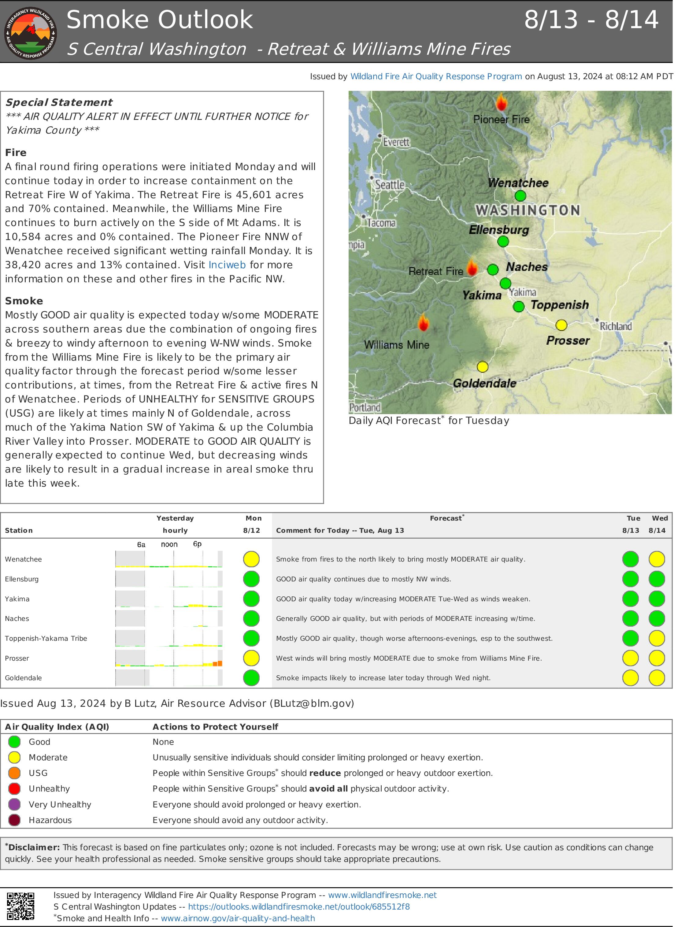
Retreat Fire Morning Update August 13 2024 08 13 2024
Related Incident: Retreat
Publication Type: News
Retreat Fire Morning Update - August 13, 2024
Fire Information: 509-213-4890, 8 a.m. to 8 p.m.
Email: 2024.Retreat@firenet.gov
Linktree: linktr.ee/CIIMT14
Current Situation: Yesterday, firefighters were successful with tactical firing operations along the western flank south of Bethel Ridge. This work will continue as the weather allows. Limited, and mostly interior, hot spots and smoke were detected over the entire fire area during an aerial reconnaissance flight.
Today, firefighters will spend extra effort assessing trees that may have been damaged and could fall in their work area prior to continuing mop-up operations. Crews will patrol the areas of Camp Ghormley, Lost Lake Road, and the Highway 12 corridor, and work to complete an alternative control line (shaded fuel break) along Forest Roads 1200 and 1201 to protect structures in the Rimrock Lake area. Firefighters have begun removing unneeded equipment and fire hose from the fireline and are beginning fire suppression repair (road grading, hazard tree felling, and dozer line repair) where they are confident the fire is fully contained.
Along State Highway 12, crews are working to remove hazard trees that pose a threat to both firefighters and the public. Removing these hazards, as well as addressing infrastructure damage (burned out guard rails posts, etc.), along this highway remains a top priority so this route can be opened and evacuation orders can be lifted as soon as possible.
The Retreat Fire is being managed under a full suppression strategy, prioritizing public and firefighter safety.
Weather: Consistent northwest wind will continue to bring cool/humid air from the coast. Winds will be strongest in the morning and overnight with gusts to 24mph. Minimum humidity’s will be 30-40% an increase of 9-10% from previous days. Temperatures over the fire area will be in the mid 60’s.
Evacuations: For the most up-to-date information on evacuations, please visit the Yakima County Emergency Management website at yakimacounty.us/350.
Fire Closures:
- US Highway 12 remains closed between the Y at Highway 410 and the summit of the pass at milepost 151.
- Okanogan-Wenatchee National Forest Retreat Fire Closure (tinyurl.com/5ext5aec).
- The Washington State Department of Natural Resources (DNR) Southeast Region has temporarily closed part of the Ahtanum State Forest. The public can access the most up-to-date closure information at dnr.wa.gov/ahtanum.
- Washington Department of Fish and Wildlife has closed the majority of the Oak Creek Wildlife Area to public access due to the Retreat Fire until August 23, 2024. More information can be found at tinyurl.com/bdet7845.
Air Quality and Smoke: Air quality and smoke condition outlooks can be found at airnow.gov.
Middle Fork Complex wapiti Bulltrout Daily Update 08 13 2024
Related Incident: Bulltrout Fire
Publication Type: News
Incident Commander: Rick Connell, Northern Rockies Team 5
Middle Fork Complex Location: 9 miles east of Garden Valley, ID
Bulltrout Location: 15 miles WNW OF Stanley, ID Wapiti Location: 2 miles southwest of Grandjean, ID
Start Dates: 07/24/24 – 08/06/2024
Cause: Lightning
Size:
Bulltrout: 271 acres Wapiti: 2,667 acres
Middle Fork Complex: Bulldog: 2,100 acres Nellie: 3,681 acres
Containment: Middle Fork Complex: 0% Bulltrout: 92% Wapiti: 0%
Resources on site:
Middle Fork Complex: 1 hotshot crew; 5 type 2 hand crew; 9 engines; 3 bulldozers; 3 water tenders
Wapiti: 1 type 2 hand crew; 8 engines; 1 water tender
Bulltrout: 2 engines
Total Personnel: Middle Fork Complex: 300 Bulltrout:20 Wapiti: 57
KEY MESSAGE:
Join us for a Middle Fork Complex, Bulltrout, and Wapiti Fire Community Meeting Today at 7pm for an in-person explanation of current fire activity and planned actions on these fires. The Community Meeting will be located at the Lowman Emergency Services Station 80, at 8000 HWY 21, Lowman, ID. Also, the Boise National Forest adjusted the fire closure areas.
CURRENT STATUS/PLANNED ACTIONS:
Middle Fork Complex: The Middle Fork Complex is comprised of Bulldog, Nellie, and Anderson fires.
On the Bulldog Fire, strategic overnight firing operations along the south side of the fire were successful in connecting with the historic Pioneer fire burn area. Firefighters continue to secure the edge of the fire. On the north side of the fire crews are working with terrain and fuels to create a fuel break. The public is reminded that the Middle Fork Road is closed at the Forest Service boundary just south of Lightning Creek for firefighter and public safety as crews continue to work to protect private property and structures in the vicinity of Crouch.
On August 12th the Nellie and Anderson fires merged and will now be treated as one fire and retain the name Nellie. The current containment on the newly combined Nellie fire is 0%. The fire is burning in steep remote terrain and is backing into the 2016 Pioneer fire area. Crews plan to utilize unmanned aerial system (UAS) today to conduct strategic firing operations ahead of the fire to reduce fuels availability. The public is reminded that Forest Service Road #555 is closed at the intersection of Highway 17.
Wapiti Fire: Wapiti fire has been active in areas exposed to winds in upper elevations and ridges. Firefighters continue to ensure the structures in the vicinity of the fire are protected with improved defensible space, with an extensive sprinkler and water pumping system in communities near the fire. Crews are evaluating the Hanging Valley subdivision. Smoke may be visible from State Highway 21 please use caution while driving in the area. A predominant ridge on the west side of the fire is being assessed for opportunities to conduct strategic firing operations when conditions are favorable. On the south side of the fire is a historic fire area is adjacent to the fire and remains less receptive to fire activity.
Bulltrout Fire: The fire is 92% contained and firefighters continue suppression repair in areas affected by the fire. The fire is smoldering and creeping through unburned areas within the interior of the fire and crews continue patrolling and extinguishing pockets of heat in the interior of the fire on the south side of the fire.
WEATHER AND FIRE BEHAVIOR:
Yesterday the inversion lifted mid-afternoon as predicted, and the fires experienced west-southwest winds around 15 mph. Today a weak weather system is passing through the area and intermittent showers are expected and outflow winds may be possible. Thunderstorms in the morning will move out of the area around 1200 PM and conditions will remain cooler. An increase in fire activity is expected if outflow winds impact fire areas and when the sky clears. Fires are burning in timber and understory with group torching, spread will continue in all directions.
CLOSURES, RESTRICTIONS, AND EVACUATIONS:
Middle Fork Complex: The Boise County Sheriff's Office continues to maintain the Level 2 evacuation notice for residents on and near the Middlefork Road between Stump Ranch Road up to Tie Creek Campground. The Boise National Forest issued areas closure for the fire area (Closure #0402-06-59 and Closure # 0402-05-93). Effective August 12, 2024. The purpose of these orders is to protect public safety during the fires.
Wapiti Fire: The evacuation order for Summer Homes and the Sawtooth Lodge remain in effect for the Wapiti Fire, as does the area closure issued by the Sawtooth and Boise National Forests (Closure #0402-05-94) Effective August 12, 2024. This Order is for public and firefighter safety during fire suppression efforts of the Wapiti Fire.
Bulltrout Fire: The Bull Trout Fire Area Closure (Closure #0402-05-93) remains in effect for the roads, trails within the perimeter of the fire. Boise National Forest issued this order on August,12, 2024. It will be rescinded as soon as it is safe to do so.
Closure information and maps are posted on the Forests’ website and the fire’s Inciweb page as they are in place. https://tinyurl.com/2u8v3pf7
The Boise National Forest, Idaho Department of Lands, and Bureau of Land Management are in Stage 1 fire restrictions on state, endowment, private and federal lands within the West Central Mountains Fire Restrictions Zone. For more information on the restrictions and a map visit:
https://www.idl.idaho.gov/fire-management/fire-restrictions-finder/
WEST MOUNTAIN COMPLEX Boulder Snag and Dollar Fires Update 08 13 2024
Related Incident: Wolf Creek Fire
Publication Type: News
**WEST MOUNTAIN COMPLEX: Boulder, Snag, and Dollar Fires Update 08-13-2024**
Red Flag Warning is in effect for today. This warning was issued for thunderstorms, lightning, and gusty winds. Predicted storms have the potential to bring erratic gusts accompanied with rapid wind shifts.
Fire activity was subdued across the Wolf Creek Fire yesterday, and firefighters continue to progress with mop up tactics to strengthen the containment line. Priority was placed on areas of heat that had potential for torching. Torching describes a fire pattern of extremely hot fire that moves rapidly up a tree; the hotter the fire, the faster it burns. This could lead trees, such as subalpine firs, to throw embers over the containment line. Accordingly, crews continue looking for spot fires and are diligently extinguishing areas of heat along the fire perimeter. Containment is expected to continue increasing as the fire remains in its current footprint.
WEST MOUNTAIN COMPLEX Boulder Snag and Dollar Fires Update 08 13 2024
Related Incident: Boulder Fire
Publication Type: News
**WEST MOUNTAIN COMPLEX: Boulder, Snag, and Dollar Fires Update 08-13-2024**
A Red Flag Warning is in effect for today. This warning was issued for thunderstorms, lightning, and gusty winds. Predicted storms have the potential to bring erratic gusts accompanied with rapid wind shifts.
The night shift used fire suppression tactics to hold and patrol fire perimeter lines strengthened during day operations. Firefighters continue to construct and improve control line from the south to road 421E back into the fire perimeter. Crews look for opportunities to utilize firing operations to increase areas of “black” between the handline and the fire perimeter. The "black” denotes a condition where there is no unburned material between the fireline and the fire edge. This provides a strong containment line and eliminates fuels that could lead to fire growth.
Middle Fork Complex Wapiti Bulltrout Daily Update 08 13 2024
Related Incident:
Publication Type: News
Incident Commander: Rick Connell, Northern Rockies Team 5
Middle Fork Complex Location: 9 miles east of Garden Valley, ID
Bulltrout Location: 15 miles WNW OF Stanley, ID Wapiti Location: 2 miles southwest of Grandjean, ID
Start Dates: 07/24/24 – 08/06/2024
Cause: Lightning
Size:
Bulltrout: 271 acres Wapiti: 2,667 acres
Middle Fork Complex: Bulldog: 2,100 acres Nellie: 3,681 acres
Containment: Middle Fork Complex: 0% Bulltrout: 92% Wapiti: 0%
Resources on site:
Middle Fork Complex: 1 hotshot crew; 5 type 2 hand crew; 9 engines; 3 bulldozers; 3 water tenders
Wapiti: 1 type 2 hand crew; 8 engines; 1 water tender
Bulltrout: 2 engines
Total Personnel: Middle Fork Complex: 300 Bulltrout:20 Wapiti: 57
KEY MESSAGE:
Join us for a Middle Fork Complex, Bulltrout, and Wapiti Fire Community Meeting Today at 7pm for an in-person explanation of current fire activity and planned actions on these fires. The Community Meeting will be located at the Lowman Emergency Services Station 80, at 8000 HWY 21, Lowman, ID. Also, the Boise National Forest adjusted the fire closure areas.
CURRENT STATUS/PLANNED ACTIONS:
Middle Fork Complex: The Middle Fork Complex is comprised of Bulldog, Nellie, and Anderson fires.
On the Bulldog Fire, strategic overnight firing operations along the south side of the fire were successful in connecting with the historic Pioneer fire burn area. Firefighters continue to secure the edge of the fire. On the north side of the fire crews are working with terrain and fuels to create a fuel break. The public is reminded that the Middle Fork Road is closed at the Forest Service boundary just south of Lightning Creek for firefighter and public safety as crews continue to work to protect private property and structures in the vicinity of Crouch.
On August 12th the Nellie and Anderson fires merged and will now be treated as one fire and retain the name Nellie. The current containment on the newly combined Nellie fire is 0%. The fire is burning in steep remote terrain and is backing into the 2016 Pioneer fire area. Crews plan to utilize unmanned aerial system (UAS) today to conduct strategic firing operations ahead of the fire to reduce fuels availability. The public is reminded that Forest Service Road #555 is closed at the intersection of Highway 17.
Wapiti Fire: Wapiti fire has been active in areas exposed to winds in upper elevations and ridges. Firefighters continue to ensure the structures in the vicinity of the fire are protected with improved defensible space, with an extensive sprinkler and water pumping system in communities near the fire. Crews are evaluating the Hanging Valley subdivision. Smoke may be visible from State Highway 21 please use caution while driving in the area. A predominant ridge on the west side of the fire is being assessed for opportunities to conduct strategic firing operations when conditions are favorable. On the south side of the fire is a historic fire area is adjacent to the fire and remains less receptive to fire activity.
Bulltrout Fire: The fire is 92% contained and firefighters continue suppression repair in areas affected by the fire. The fire is smoldering and creeping through unburned areas within the interior of the fire and crews continue patrolling and extinguishing pockets of heat in the interior of the fire on the south side of the fire.
WEATHER AND FIRE BEHAVIOR:
Yesterday the inversion lifted mid-afternoon as predicted, and the fires experienced west-southwest winds around 15 mph. Today a weak weather system is passing through the area and intermittent showers are expected and outflow winds may be possible. Thunderstorms in the morning will move out of the area around 1200 PM and conditions will remain cooler. An increase in fire activity is expected if outflow winds impact fire areas and when the sky clears. Fires are burning in timber and understory with group torching, spread will continue in all directions.
CLOSURES, RESTRICTIONS, AND EVACUATIONS:
Middle Fork Complex: The Boise County Sheriff's Office continues to maintain the Level 2 evacuation notice for residents on and near the Middlefork Road between Stump Ranch Road up to Tie Creek Campground. The Boise National Forest issued areas closure for the fire area (Closure #0402-06-59 and Closure # 0402-05-93). Effective August 12, 2024. The purpose of these orders is to protect public safety during the fires.
Wapiti Fire: The evacuation order for Summer Homes and the Sawtooth Lodge remain in effect for the Wapiti Fire, as does the area closure issued by the Sawtooth and Boise National Forests (Closure #0402-05-94) Effective August 12, 2024. This Order is for public and firefighter safety during fire suppression efforts of the Wapiti Fire.
Bulltrout Fire: The Bull Trout Fire Area Closure (Closure #0402-05-93) remains in effect for the roads, trails within the perimeter of the fire. Boise National Forest issued this order on August,12, 2024. It will be rescinded as soon as it is safe to do so.
Closure information and maps are posted on the Forests’ website and the fire’s Inciweb page as they are in place. https://tinyurl.com/2u8v3pf7
The Boise National Forest, Idaho Department of Lands, and Bureau of Land Management are in Stage 1 fire restrictions on state, endowment, private and federal lands within the West Central Mountains Fire Restrictions Zone. For more information on the restrictions and a map visit:
https://www.idl.idaho.gov/fire-management/fire-restrictions-finder/
Red Fire Daily Update 08132024 08 13 2024
Related Incident: Red Fire
Publication Type: News
RED FIRE DAILY UPDATE Tuesday, August 13, 2024
541-208-1766, 2024.red@firenet.gov https://inciweb.wildfire.gov/incident-information/ordef-red-fire https://www.facebook.com/2024RedFireOR/
Size: 659 acres
Start Date: July 17, 2024 Cause: Lightning Containment: 0% Total Personnel: 267
Location: 5 miles west of Crescent Lake Junction, OR County: Klamath
Crescent, OR – The Red Fire is burning within the Diamond Peak Wilderness of the Deschutes National Forest, on the southwest slope of Redtop Mountain. The fire is being managed under a full suppression strategy. Public and firefighter safety is the highest priority in managing this fire.
Yesterday’s Activities - Firefighters continued checking and prepping structures as well as preparing the final touches on the shaded fuel break. Completed and tested sprinkler systems. The fire continued to primarily burn back in on itself but did grow 50 acres along the southern edge.
Today’s Activities –. Today crews will focus on securing established control lines, chipping of wood debris, and continued strengthening of defensible areas. Equipment will continue to rotate around the fire to areas still needing work. Scouts will continue to look for areas to engage the fire directly and opportunities to safely insert more resources.
Weather and Smoke –. As the cloudy skies continue to clear in the fire area that slight moisture change in the fuel beds bringing higher relative humidity. Relative humidity is the main factor as it is always changing slowly with the predicted weather. Burning will be moderate to slow on most of the fire today. Air quality information can be found at https://fire.airnow.gov/.
Closures – The Deschutes National Forest has implemented an emergency closure around Crescent Lake and in the Diamond Peak Wilderness. The public should note that Forest Service Road 60 is closed, and road guards have been posted for public safety. More closure information is available at: https://www.fs.usda.gov/alerts/deschutes/alerts-notices/?aid=89091
Evacuations – The WILDFIRE! Level 1 – BE READY to Evacuate notice issued by Klamath County Emergency Management for the Crescent Lake, Odell Lake, and Crescent Junction areas remains in effect (INCENDIO FORESTAL! Nivel 1 - ESTÉ PREPARADO para evacuar de las siguientes zonas: Crescent Lake, Odell Lake, Crescent Junction). Visit www.klamathcounty.org/300/emergency-management for more information or to sign up for alerts.
Fire Restrictions – Stage 2 Public Use Fire Restrictions – which prohibit open fires, including in developed campgrounds – are in effect for the Deschutes National Forest. The Industrial Fire Precaution Level is currently Level IV “General Shutdown.” Visit fs.usda.gov/detail/deschutes/home/?cid=stelprdb5297376 for more information.
Drone Restrictions – A Temporary Flight Restriction is in place over the Red Fire area. Unauthorized drone (UAS) flights pose serious risks to the effectiveness of wildfire suppression operations. Aerial firefighting is suspended when unauthorized UAS are in the area, allowing wildfires to grow larger. If you fly, we can’t.
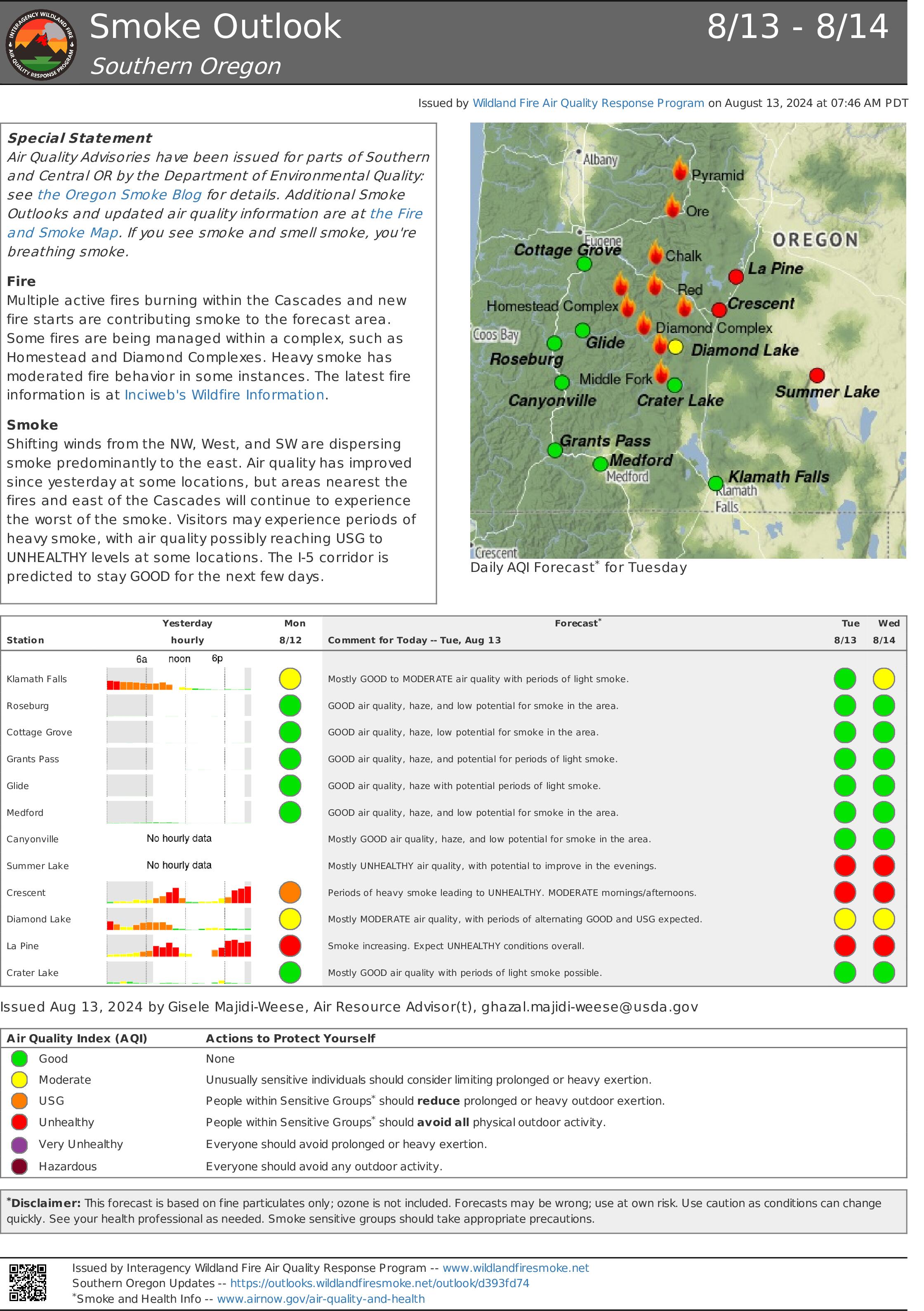
Homestead Complex Fire Update08 13 2024
Related Incident:
Publication Type: News
HOMESTEAD COMPLEX FIRE UPDATE
Fire Information Tuesday, August 13, 20
Phone: 541-208-7100 (8 a.m. to 8 p.m.)
Email: 2024.homesteadcomplex@firenet.gov
Facebook: www.facebook.com/HomesteadComplexFireInfo
Inciweb: http://inciweb.wildfire.gov/incident-information/orupf-homestead-complex
Smoke Outlook: https://outlooks.airfire.org/outlook/d393fd74
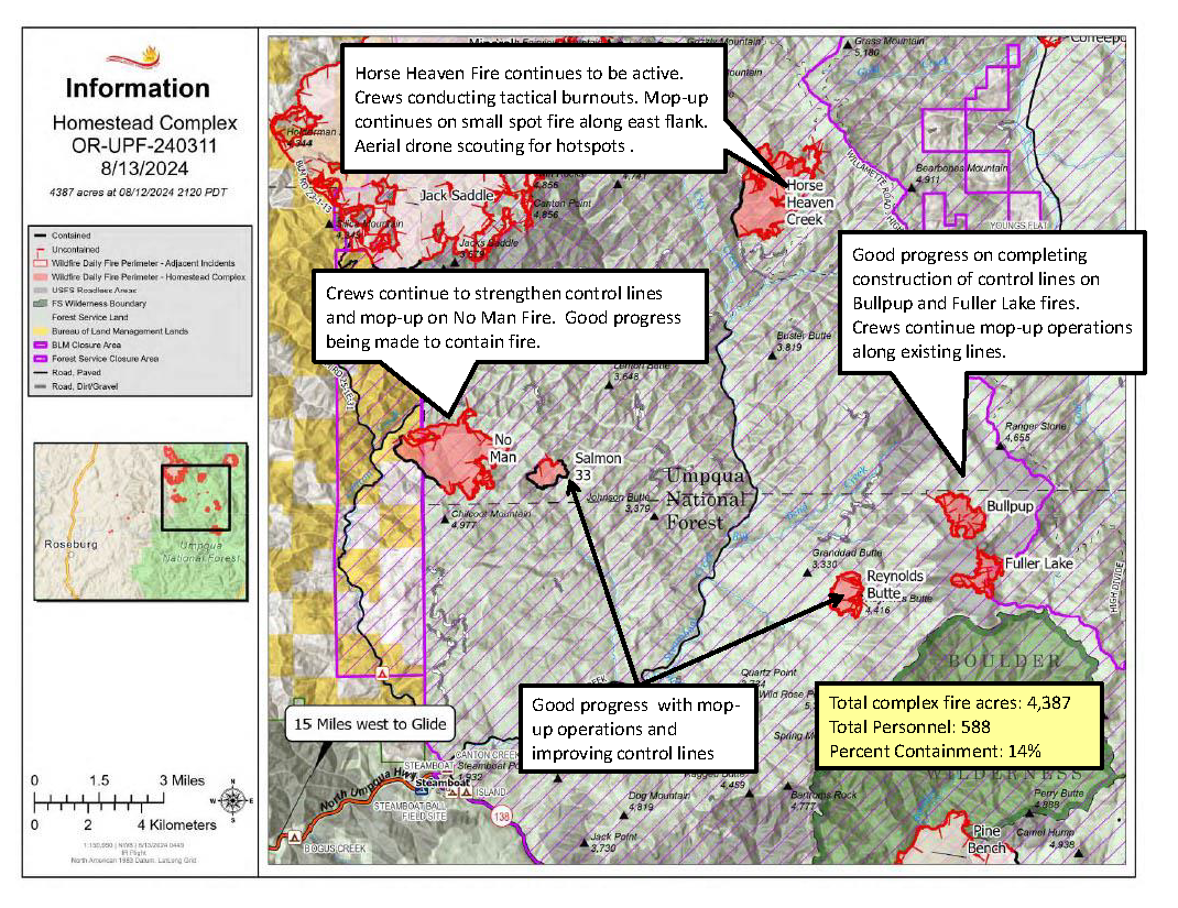
The Homestead Complex includes seven fires totaling 4,387 acres with an overall containment of 14%. There are 588 personnel currently working on the fire. Fire managers continue directing resources to fires based on threats to property, infrastructure, industry, and areas with the highest probability of success while providing for firefighter and public safety. The fire is being managed by Northwest Incident Management Team 8.
Yesterday, on the No Man Fire (1,660 acres), crews had good success with tactical firing operations inside established dozer line on the northern side of the fire, deepening the containment lines. Holding and mop-up efforts continued to progress. To the south, firefighters completed testing of the hoselays and prepared for today’s planned burnout, which will head west and north for several shifts. The Salmon 33 (244 ac.) Fire showed minimal movement and fire personnel focused on mop up and increased containment. Horse Heaven Creek Fire (1,369 ac.) continued to show growth to the east but did not push up against any lines. A hotshot crew scouted the area with a drone, and firefighters conducted burnouts in the northeast corner of the fire down the eastern flank from the 130 spur. On the southern side, the fire reached the 015 spur and was successfully held with engines and a skidgine. On both Fuller Lake (332 ac.) and Bullpup (413 ac.) fires, engines continued to hold the fires along the road systems while indirect line was constructed with heavy equipment. The Reynolds Butte Fire (335 ac) saw minimal activity and continues to be in great shape. Fire personnel were still engaged in mop-up work along containment lines.
Today on the No Man Fire, burnout operations will be the priority on the southern side of the fire as crews continue to build and improve containment line and prep roads. To the northern side of the fire, lines held overnight after yesterday’s tactical firing operations and firefighters will focus on mop-up today. Crews on the Salmon 33 Fire will be working on finishing indirect line to the west, and monitoring and mopping up around the footprint as minimal fire activity continues. On the Horse Heaven Creek Fire, crews will be tying in a two-acre spot on the east flank and then continuing yesterday’s burnout operations down from the 130 spur moving south. Drone scouting will continue in the north around the Windy Creek area, and contingency line construction is ongoing off the 5850 Road. The Bullpup and Fuller fires are holding on the east side, and crews will focus on mop up and solidifying their holds on the 5851 and 300 roads as fire continues to flank along them. Firefighters will scout north along both roads as well. The Reynolds Butte Fire remains close to patrol status. Crews continue to wrap up operations there and will be reallocated around the complex once work is complete. The Lost Bucket Fire (34 ac.) was contained on July 29 and remains in a patrol status.
Today’s weather: The marine layer did return overnight but didn’t entirely pass over the fire footprint. Relative humidity recovery was still good, in the 90-percent range. Temperatures will range in the 60s and 70s today and relative humidity should be in the 40-50 percent range, perhaps slightly lower than yesterday. Terrain-driven winds during the morning and noon hours will pick up at the higher elevations into the afternoon, with west-northwesterly gusts up to 20 mph possible. Temperatures should warm a little tomorrow.
Current forest fire restrictions and danger ratings are:
Fire Danger Rating: Very High
Industrial Fire Precaution Levels (IFPL): 3
Public Use Fire Restrictions (PUR): 3
CLOSURES:
The Bureau of Land Management (BLM), Roseburg District, has issued a closure order for portions of BLM land which border the Umpqua National Forest Emergency Fire Closure north of Steamboat. The closure order can be viewed here: https://www.blm.gov/sites/default/files/docs/2024-07/orwa-fpo-rbg-072624.pdf.
The Umpqua National Forest has Emergency Fire Closures in place impacting every district of the forest. https://www.fs.usda.gov/alerts/umpqua/alerts-notices.
Fire Prevention:
Continue to check for Fire Restrictions when recreating or working outside. Agencies use weather forecasts, the current regional and national fire situation, resource availability and many other factors to calculate appropriate fire restriction levels. Do your part to help keep unwanted human fire starts off of the landscape! #onlyyoucanpreventwildfires #itonlytakesonespark