
BAER INFORMATION BRIEF Key Elements of A BAER Assessment 08 13 2024
Related Incident: Borel Post-Fire BAER
Publication Type: News
BAER INFORMATION BRIEF: Key Elements of A BAER Assessment
Forest Service BAER assessment teams are established by Forest Supervisors before wildfires are fully contained. The teams coordinate and work with the USDA Natural Resources Conservation Service (NRCS), Bureau of Land Management (BLM), Fish & Wildlife Service (FWS), National Weather Service (NWS), local counties, State Department of Transportation, and other federal, state, and local agencies to strategically assess potential post-fire impacts to the watersheds burned from wildland fires.
The BAER assessment teams are evaluating watershed conditions to determine the level of potential risks to human life, safety, property, critical natural and cultural-heritage resources, and determine if there are appropriate and effective emergency stabilization measures that can be implemented on federal lands in a timely manner to reduce unacceptable risks from potential flooding and debris flow threats.
The BAER assessment team conducts field surveys and uses science-based models to rapidly evaluate and assess the burned area.
BAER assessment teams are staffed by specially trained professionals that may include: hydrologists, soil scientists, engineers, geologists, biologists, botanists, archeologists, geographic information system mapping specialists, recreation and trails specialists, and others who evaluate the burned area and prescribe emergency response actions to protect the land quickly and effectively.
BAER assessments usually begin before a wildfire has been fully contained.
The BAER assessment team generates a “Soil Burn Severity” map by using satellite imagery which is then validated and adjusted by BAER team field surveys to assess watershed conditions and watershed response to the wildfire. The map identifies areas of soil burn severity by categories of low/unburned, moderate, and high which corresponds to a projected increase in watershed response.
The BAER team presents these findings and treatment recommendations to the Forest Supervisor in an assessment report that identifies immediate and emergency stabilization actions needed to address potential post-fire risks to human life and safety, property, cultural-heritage and critical natural resources on National Forest System lands.
The BAER report describes watershed pre- and post-fire response information, areas of concern for human life, safety and property, and recommended short-term emergency stabilization actions for federal lands that burned.
In most cases, only a portion of the burned area is actually treated.
If the BAER assessment team determines there may be potential emergency situations, the short-term goal is to have flood and erosion control protection measures completed before the first large, damaging rain events occur.
Timely implementation is critical if BAER emergency response actions are to be effective.
The BAER assessment team coordinates with other federal and local agencies, and counties that assist private landowners in preparing for increased run-off and potential flooding.
Federal assistance to private landowners regarding post-fire potential impacts is the primary responsibility of the NRCS through the Emergency Watershed Protection (EWP) program (www.nrcs.usda.gov/wps/portal/nrcs/main/national/programs/landscape/ewpp/)
NRCS in coordination with additional state, local and federal agencies conduct damage survey reports for the private land adjacent to and downstream from the burned areas. NRCS uses these reports, along with the BAER team’s assessment report, to develop recommended emergency measures for businesses and private home and landowners to reduce the impacts to their property from potential increased water and debris flows.
BAER SAFETY MESSAGE: Everyone near and downstream from the burned areas should remain alert and stay updated on weather conditions that may result in heavy rains and increased water runoff. Flash flooding may occur quickly during heavy rain events--be prepared to act. Current weather and emergency notifications can be found at National Weather Service website: www.weather.gov/hnx/.
BAER INFORMATION BRIEF Forest Service BAER Program Overview 08 13 2024
Related Incident: Borel Post-Fire BAER
Publication Type: News
BAER INFORMATION BRIEF: Forest Service BAER Program Overview
The Burned Area Emergency Response (BAER) program is designed to identify and manage potential risks to resources on National Forest System lands and reduce these threats through appropriate emergency measures to protect human life and safety, property, and critical natural or cultural resources. BAER is an emergency program for stabilization work that involves time-critical activities to be completed before the first damaging event to meet program objectives:
BAER Objectives:
- Determine whether imminent post-wildfire threats to human life and safety, property, and critical natural or cultural resources on National Forest System lands exist and take immediate actions, as appropriate, to manage the unacceptable risks.
- If emergency conditions are identified, mitigate significant threats to health, safety, human life, property, and critical cultural and natural resources.
- Prescribe emergency response actions to stabilize and prevent unacceptable degradation to natural and cultural resources, to minimize threats to critical values resulting from the effects of a fire, or to repair/replace/construct physical improvements necessary to prevent degradation of land or resources.
- Implement emergency response actions to help stabilize soil; control water, sediment and debris movement and potentially reduce threats to the BAER critical values identified above when an analysis shows that planned actions are likely to reduce risks substantially within the first year following containment of the fire.
- Monitor the implementation and effectiveness of emergency treatments that were applied on National Forest System lands.
While many wildfires cause minimal damage to the land and pose few threats to the land or people downstream, some fires result in damage that requires special efforts to reduce impacts afterwards. Loss of vegetation exposes soil to erosion; water run-off may increase, and cause flooding, soil and rock may move downstream and damage property or fill reservoirs putting community water supplies and endangered species at-risk.
The BAER team presents these findings in an assessment report that identifies immediate and emergency actions needed to address post-fire risks to human life and safety, property, cultural and critical natural resources. This includes early detection and rapid response (EDRR) treatments to prevent the spread of noxious weeds into native plant communities. The BAER report describes watershed pre- and post-fire watershed response information, areas of concern for life and property, and recommended short-term emergency stabilization measures for Forest Service lands that burned.
In most cases, only a portion of the burned area is actually treated. Severely burned areas steep slopes, and places where water run-off will be excessive and may impact important resources, are focus areas and described in the BAER assessment report if they affect critical values. Time is critical if the emergency stabilization measures are to be effective.
A BAER assessment team conducts field surveys and uses science-based models to rapidly evaluate and assess the burned area and prescribe emergency stabilization measures. The team generates a “Soil Burn Severity” map by using satellite imagery which is then validated and adjusted by BAER team field surveys to assess watershed conditions and model potential watershed response from the wildfire. The map identifies areas of soil burn severity by categories of very low/unburned, low, moderate, and high which may correspond to a projected increase in watershed response. The higher the burn severity, the less the soil will be able to absorb water when it rains. Without absorption, there will be increased run-off with the potential of flooding.
BAER Funding:
Special Emergency Wildfire Suppression funds are authorized for BAER activities and the amount of these expenses varies with the severity of the fire season. Some years see little BAER activity while other years are extremely busy.
Because of the emergency nature of BAER, initial requests for funding of proposed BAER treatments are supposed to be submitted by the Forest Supervisor to the Regional Office within 7 days of total containment of the fire. The Regional Forester’s approval authority for individual BAER projects is limited. Approval for BAER projects exceeding this limit is to the Washington Office.
BAER SAFETY MESSAGE: Everyone near and downstream from the burned areas should remain alert and stay updated on weather conditions that may result in heavy rains and increased water runoff. Flash flooding may occur quickly during heavy rain events-be prepared to act. Current weather and emergency notifications can be found at National Weather Service website: www.weather.gov/hnx/.
THREE PHASES OF WILDFIRE RECOVERY 08 13 2024
Related Incident: Borel Post-Fire BAER
Publication Type: News
Post-Fire BAER Assessment
Burned Area Emergency Response (BAER)
THREE PHASES OF WILDFIRE RECOVERY
There are three phases of recovery following wildfires on federal lands:
- Fire Suppression Repair
- Emergency Stabilization-Burned Area Emergency Response (BAER)
Long-Term Recovery and Restoration
Fire Suppression Repair is a series of immediate post-fire actions taken to repair damages and minimize potential soil erosion and impacts resulting from fire suppression activities and usually begins before the fire is contained, and before the demobilization of an Incident Management Team. This work repairs the hand and dozer fire lines, roads, trails, staging areas, safety zones, and drop points used during fire suppression efforts.
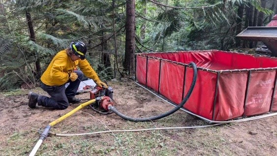
Emergency Stabilization-Burned Area Emergency Response (BAER) is a rapid assessment of burned watersheds by a BAER team to identify imminent post-wildfire threats to human life and safety, property, and critical natural or cultural resources on National Forest System lands and take immediate actions to implement emergency stabilization measures before the first post-fire damaging events. Fires result in loss of vegetation, exposure of soil to erosion, and increased water runoff that may lead to flooding, increased sediment, debris flows, and damage to critical natural and cultural resources. BAER actions such as: mulching, seeding, installation of erosion and water run-off control structures, temporary barriers to protect recovering areas, and installation of warning signs may be implemented. BAER work may also replace safety related facilities; remove safety hazards; prevent permanent loss of habitat for threatened and endangered species; prevent the spread of noxious weeds and protect critical cultural resources.
Long-Term Recovery and Restoration utilizes non-emergency actions to improve fire-damaged lands that are unlikely to recover naturally and to repair or replace facilities damaged by the fire that are not critical to life and safety. This phase may include restoring burned habitat, reforestation, other planting or seeding, monitoring fire effects, replacing burned fences, interpreting cultural sites, treating noxious weed infestations, and installing interpretive signs.
BAER SAFETY MESSAGE: Everyone near and downstream from the burned areas should remain alert and stay updated on weather conditions that may result in heavy rains and increased water runoff. Flash flooding may occur quickly during heavy rain events--be prepared to act. Current weather and emergency notifications can be found at National Weather Service website: www.weather.gov/hnx/.
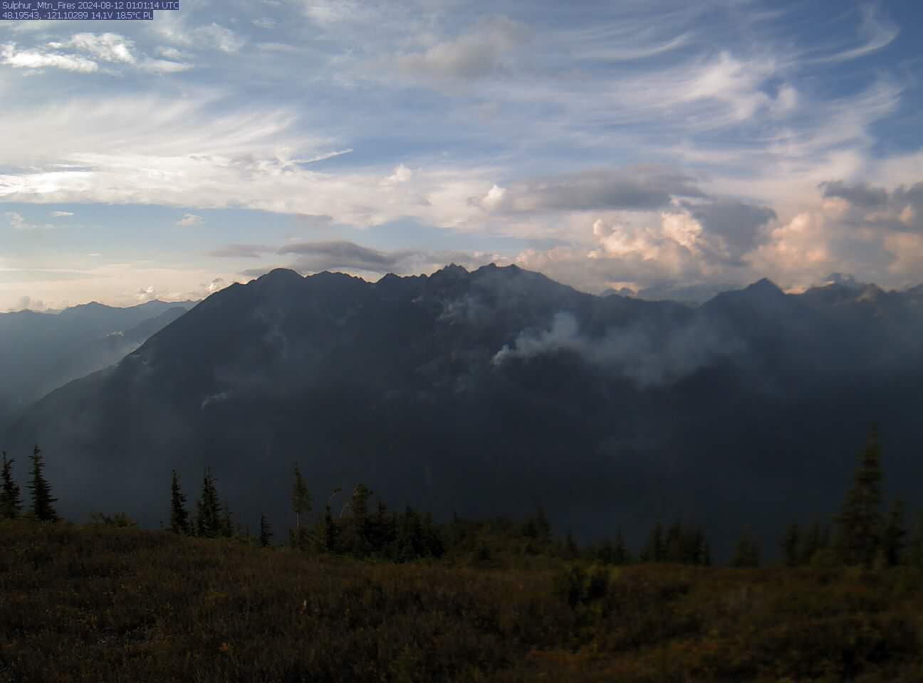
Miners Complex Daily Update 08 13 2024
Related Incident: Miners Complex Fires
Publication Type: Announcement
11:00 AM, August 13, 2024
Estimated size: 1,098 acres
Start Date/Time: July 17, 2024
Area of Origin: 21 air miles east of Darrington WA
Cause: Lightning
Fuels/Topography: timber, rugged terrain
Structures Damaged: None, there are no homes threatened at this time.
Evacuations: None
The Miners Complex consists of ten wildfires caused by lightning strikes in the Mt. Baker-Snoqualmie National Forest. The fires included in the complex are: Miners Fire, Vista Ridge Fire, Dolly Creek Fire, Sulphur Three Fire, Sulphur Four Fire, Sulphur Thirty-Four Fire, Upper Sulphur Thirty-Two Fire, Lower Sulphur Thirty-Two Fire, Plummer, and Middle Ridge Fire.
Update: Firefighters patrolled and monitored the area and saw little activity with the cooler weather. Monitoring will continue, as well as planning strategies for any increase in size that could threaten resources.
Weather: Showers will be mainly toward the crest today. A trough will continue to bring cooler conditions with excellent humidity recoveries. Slightly warmer on Wednesday but humidities remain high. Max temperatures around 64 degrees. Light winds becoming west 5 to 6 mph in the afternoon.
Smoke: For more information on smoke and air quality please visit: https://wasmoke.blogspot.com/
Closures: The following is a summary of the areas closed due to the fires in the Miners Complex. Pacific Crest National Scenic Trail #2000.2 from Mica Lake to Suiattle Pass, Suiattle River Trail #784, Miners Ridge Trail #785, Buck Creek Pass Trail #789, Miners Cabin Trail #795, Grassy Point Trail #788, Sulphur Mountain Trail #794, Sulphur Creek Trail #793, Sulphur Creek Campground, Sulphur Creek Trailhead, and the Downey Creek trailhead. The full Closure Orders visit: https://www.fs.usda.gov/mbs
Forest Restrictions: The Mt. Baker-Snoqualmie has a full campfire ban and forest-wide shooting restrictions in place to help prevent human-caused starts during this period of unprecedented resource scarcity. Additional details at: www.fs.usda.gov/mbs
###
Tuesday Morning Update for the Park Fire 08 13 2024
Related Incident: Park Fire
Publication Type: News
Morning of Tuesday, August 13, 2024
For more information on the Park Fire, please visit: https://inciweb.wildfire.gov/incident-information/calnf-park-fire
Size: 429,259 acres with 39% containment | Personnel: 5,638
Lassen National Forest:
Firefighters continued to patrol the Park Fire overnight. With no additional growth, increased containment, and improving weather conditions, the amount of remaining hot spots along the fire’s edge and potential for additional growth will continue to decrease. Firefighters on the ground continue to be assisted by the infrared capabilities of Unmanned Aircraft Systems (UAS) and aircraft to locate remaining hot spots and extinguish them.
Today, firefighting resources are focused on hazard tree removal along roadways and the fire perimeter, suppression repair efforts, strengthening existing fire line, and patrol of the entire fire perimeter.
While fuels remain extremely dry, today’s weather forecast includes lower temperatures, calmer winds, and slightly higher relative humidity values.
Fuels burning within the fire perimeter can smolder for days hidden beneath a layer of ash. The smolder vegetation within the fire perimeter is not a threat to the existing containment.
However, firefighters will continue to aerial heat detection to extinguish any heat near the fire’s edge.
The #ParkFire has burned 113,736 acres on the Lassen National Forest.
CAL FIRE:
Fire behavior was subdued overnight due to higher humidity. The fire is primarily burning in timber and dead and down vegetation.
Today we continue mop-up and tactical patrol in some areas of the fire. Firefighters will continue working going direct and mitigating any potential spot fires near roadways.
Repopulations are occurring where it is safe to do so, with multiple orders also reduced to warnings recently. Please stay diligent while on the roads as crews and equipment may be working in the area.
For more information on the Park Fire please visit:
- CALFIRE Park Fire: https://www.fire.ca.gov/incidents/2024/7/24/park-fire
- CAL FIRE Shasta-Trinity Unit/Shasta County Fire Department: https://www.facebook.com/CALFIRESHU
- CAL FIRE Tehama-Glenn Unit/ Tehama County Fire Dept: https://www.facebook.com/CALFIRETGU
- Butte County, CA: https://www.facebook.com/ButteCounty
- Butte County Sheriff: https://www.facebook.com/bcsonews
- Plumas County Sheriff: https://www.facebook.com/plumascountysheriff
- Shasta County Sheriff: https://www.facebook.com/ShastaSheriff
- Tehama County Sheriff: https://www.facebook.com/profile.php?id=100088640404140
Pincer Two Fire Daily Update 08 13 2024
Related Incident: Pincer Two Fire
Publication Type: Announcement
11:00 AM, August 13, 2024
Estimated size: 189 acres
Start Date/Time: July 17, 2024
Area of Origin: Johannesburg Mountain. 1 Mile East of Mineral Park C.G.
Cause: Lightning
Fuels/Topography: Timber, rugged terrain
Structures Damaged: None, there are no homes threatened at this time.
Evacuations: None
Closures: Cascade River Road at and including Marble Creek Campground, Mineral Park Campground, and all tributary roads, trailheads, and trails are all closed. The public is not to enter the area for public and firefighter safety.
Full closure orders available at: https://www.fs.usda.gov/mbs
Update: Fire activity was minimal yesterday due to cooler conditions and high relative humidities (RH). High RH indicates that fuels are absorbing more moisture with the cool weather and light rains, thus lowering the potential of them burning. The fire continues to hold at the 50-foot mark from the Cascade River Road. Firefighters are continuing to patrol along the road for snags, rolling debris, and any new hot spots.
Weather: Showers will be mainly toward the crest today. A trough will continue to bring cooler conditions with excellent humidity recoveries. Slightly warmer on Wednesday but humidities remain high. Mostly cloudy (65-75 percent). Max temperatures around 64. Light winds becoming west 5 to 6 mph in the afternoon.
Smoke: For more information on smoke and air quality please visit: https://wasmoke.blogspot.com/
Air Space Restrictions: There are no air space restrictions at this time.
Forest Restrictions: The Mt. Baker-Snoqualmie has a full campfire ban and forest-wide shooting restrictions in place to help prevent human-caused starts during this period of unprecedented resource scarcity. Additional details at: www.fs.usda.gov/mbs
###
Smoke Outlook 08 13 2024
Related Incident: Park Fire
Publication Type: News
Special Statement / Declaración Especial
Smoke from fires surrounding the Outlook area continue to impact the locations.
El humo de incendios en los alrededores del área de la Perspectiva continuan afectando estas localidades.
Fire / Incendio
The fire is at 429,188 with 38% containment. The fire continues to be active in the Mill Creek drainage and in the interior of the perimeter due to heavy, dry fuels. Gusty winds are expected again today.
El incendio se encuentra en 429,188 acres con un 38% de contención. El incendio continúa activo en el drenaje de Mill Creek y en el interior del perímetro debido a combustibles pesados y secos. Se esperan vientos en ráfagas nuevamente hoy.
Smoke / Humo
Any smoke from the Park Fire will impact the areas closest to the most active portion of the fire, the Mill Creek drainage area. Air quality is overall Good to Moderate in all communities.
Cualquier humo desde el incendio Park tendrá un impacto en areas cercanas a la porción mas activa, en el área del drenaje de Mill Creek.
Be Smoke Aware / Esté atento al humo
If you smell smoke and it is impacting you, seek relief if possible.
Si huele humo y le está afectando, busque alivio si es posible.
Settings - change map background and toggle additional layers
Filter - control incident types displayed on map.
Zoom to your location
Reset map zoom and position
Could not determine your location.
Show Legend
 Wildfire
 Prescribed Fire
 Burned Area
Response
Burned Area
Response Other
Other
Borel Post-Fire BAER
Unit Information
Incident Contacts
Easy Fire Update 08 13 2024
Related Incident: Easy Fire
Publication Type: News
Easy Fire Daily Update
August 13, 2024
Quick Facts
Size: 2130 acres | Start Date: July 17, 2024 | Location: 17 miles west of Mazama, WA
Containment: 0% | Cause: Lightning | Resources Assigned: 300
CURRENT SITUATION: Washington Department of Transportation (WSDOT) road crews continue to remove debris from State Route 20 following the mudslide on Aug 11. Debris and mud currently cover approximately 100 feet of both lanes of the highway between milepost 152 and 153. Firefighting operations came to a tactical pause yesterday as heavy precipitation created a hazardous work environment. Full suppression operations will resume today.
TODAY: Leveraging gains made from the precipitation, firefighters will go direct putting people right on the fires edge in the Swamp Creek drainage area to halt the fire’s southeast spread. The ridgetop handline between the Okanogan-Skagit County line continues to hold on the east flank of the fire. Fire managers are evaluating crew access routes along the northern flank as they look to reinforce the existing handline there. Firefighters working along State Route 20 will continue improving containment lines along the roadway while removing any trees or fire debris.
WEATHER AND SMOKE: Thunderstorm chances diminish today to 20 percent. The marine layer will approach the fire area with higher humidity and cooler temperatures. Winds will largely be from the northwest with speeds of 6 to 10 mph and gusts around 15 mph.
Read full smoke report: https://outlooks.airfire.org/outlook/f79a6d6d
CLOSURES: State Route 20 will remain closed as crews continue working to mitigate hazards.
State Route 20 is closed in both directions between Granite Creek (MP 148) and Rainy Pass
(MP 157): https://wsdot.com/Travel/Real-time/Map/ .
The Okanogan-Wenatchee National Forest has closures in place for trails within the fire area: https://bit.ly/EasyFireClosures . This closure includes a portion of the Pacific Crest Trail. Campfires are prohibited.
There is a Temporary Flight Restriction (TFR) in place over the fire: https://tfr.faa.gov/save_pages/detail_4_6779.html . Unauthorized drone activity is prohibited under the TFR.
EVACUATIONS: There are no evacuations in place for the Easy Fire. Visitors recreating in the area should be vigilant of surroundings and stay out of closed areas.
InciWeb: https://inciweb.wildfire.gov/incident-information/waowf-easy-fire
Facebook: https://www.facebook.com/profile.php?id=61560760893080
Fire Information Line: 541-861-5808, 8 AM to 8 PM
Email: 2024.easy@firenet.gov
Pioneer Fire Update 08 13 2024
Related Incident:
Publication Type: News
Pioneer Fire Daily Update August 13, 2024
Quick Facts
Size: 38,420 Start Date: June 11, 2024
Location: 31 miles NW of Chelan, WA
Containment: 13 percent Personnel: 623 Cause: Human-caused, under investigation
CURRENT SITUATION: Favorable, over-night weather conditions decreased fire activity with fire behavior limited to smoldering and creeping. Fire spread in the Boulder Creek drainage has been slowed. Isolated residual heat sources in Prince Creek and Fish Creek areas are confined to extremely steep headwater slopes. The fire area will benefit from the rain for a short period before dry and hot conditions return to the fire area and Lake Chelan's strong diurnal winds and steep topography challenge suppression actions. Crews and aviation resources will respond to all new fires with an aggressive initial attack strategy. Seven new fires have been identified and contained in the local area over the last 48- hours.
TODAY’S ACTIVITIES: Crews continue to prepare contingency fire lines to be used in the rare chance the southern portion of the fire becomes active to prevent it from advancing southeast towards the community of Manson. Resources will implement structure protection plans for the community of Stehekin. Ground and aviation resources continue to take advantage of favorable weather conditions to construct direct fireline to contain the northern flank adjacent to the Boulder Creek drainage. Fire operations officials continue to evaluate the impacts from the precipitation and lightning that was received over the fire area and respond as necessary.
WEATHER AND SMOKE: The breezy down lake winds continued last night, with a quiet day expected today. A slight chance of thunderstorms is possible in the afternoon, but the chance remains small. Temperatures will continue to cool with high temperatures returning to the upper 70s to lower 80s with drier conditions. Winds will remain breezy today coming from the northwest with gusts of 20 to 25 mph possible in the late afternoon and evening hours.
For smoke report please see the report: https://outlooks.airfire.org/outlook/f79a6d6d .
EVACUATIONS: Level 1, 2 and 3 evacuation levels remain in effect around the Pioneer Fire. Please contact Chelan County Emergency Management or visit https://t.ly/QoH9w for more information.
FOREST CLOSURE: Closures for the North Cascades National Park: https://www.nps.gov/noca/index.htm
The Okanogan-Wenatchee National Forest has a closure order in place for much of the fire area: Okanogan-Wenatchee National Forest - Alerts & Closures (usda.gov). Campfires are prohibited. There is a Temporary Flight Restriction (TFR) in place over the fire: https://tfr.faa.gov/save_pages/detail_4_6779.html . Unauthorized drone activity is prohibited under the TFR.
InciWeb: https://inciweb.wildfire.gov/incident-information/wases-pioneer
Facebook: https://www.facebook.com/profile.php?id=61560760893080
Fire Information Line: 541-861-5808, 8 AM to 8 PM
Email: 2024.pioneer@firenet.gov