
Middle Fork Complex Bulldog Nellie Anderson Daily Update 08 14 2024
Related Incident:
Publication Type: News
Incident Commander: Rick Connell, Northern Rockies Team 5
Middle Fork Complex Location: 9 miles east of Garden Valley, ID
Bulltrout Location: 15 miles WNW OF Stanley, ID Wapiti Location: 2 miles southwest of Grandjean, ID
Start Dates: 07/24/24 – 08/06/2024
Cause: Lightning
Size:
Middle Fork Complex: Bulldog: 2,585 acres Nellie: 5,116 acres
Bulltrout: 271 acres Wapiti: 3,104 acres
Containment: Middle Fork Complex: 0% Bulltrout: 92% Wapiti: 0%
Resources on site:
Middle Fork Complex: 3 hotshot crews; 5 type 2 hand crews; 11 engines; 2 bulldozers; 4 water tenders
Wapiti: 1 type 2 hand crew; 8 engines; 1 water tender
Bulltrout: 1 engine
Total Personnel: Middle Fork Complex: 388 Bulltrout:18 Wapiti: 57
KEY MESSAGE:
On August 12, 2024, the Boise National Forest adjusted the fire closure areas. All roads and trails remain closed within these closures, to provide for public and firefighter safety. Please reference specific closures on the Forest’s website and the fire’s InciWeb page.
CURRENT STATUS/PLANNED ACTIONS:
Middle Fork Complex: The Middle Fork Complex is comprised of the Bulldog and Nellie fires.
On the Bulldog Fire, firefighters continue holding and extinguishing heat along the southern edge of the fire. As a result of successful strategic firing operations, crews have connected the fire perimeter to the 2006 Rattlesnake fire area and are looking for opportunities to continue to the east along the perimeter. On the north side of the fire, crews are looking for opportunities to use direct and indirect tactics to slow the spread to the west and north. The public is reminded that the Middlefork Road is closed at the Forest Service boundary just north of Lightning Creek for firefighter and public safety. Crews continue to work to protect private property and structures in the vicinity of Crouch.
The Nellie fire is burning in steep remote terrain and is backing into the 2016 Pioneer fire area. Crews are looking for natural barriers to utilize, and continue to provide point protection to lookouts and a communication tower. The public is reminded that Forest Service Road #555 is closed at the intersection of Highway 17 all the way to the Forest Service Road #579 intersection.
Wapiti Fire: The Wapiti fire is actively burning in rugged high elevation terrain. It is primarily driven by winds on ridges in exposed areas. Firefighters continue to improve the water pumping system that provides sprinklers to the communities near the fire. In the Hanging Valley subdivision, crews are working to assess the needs for structure protection. As conditions become favorable, crews plan to conduct strategic ignition operations and line construction utilizing natural barriers and the 2018 Wapiti fire area. Smoke may be visible from State Highway 21 please use caution while driving in the area.
Bulltrout Fire: The fire is 92% contained and continues to smolder and creep through unburned areas within the interior of the fire. Firefighters continue patrolling and extinguishing pockets of heat, but dead standing trees are falling within the burn area limiting access.
WEATHER AND FIRE BEHAVIOR:
Yesterday a passing weather system brought showers to the area in the morning, along with cooler
temperatures and higher relative humidity. Today moisture will remain in place, keeping afternoon relative humidity elevated and allowing for overnight recovery across all elevations. Afternoon temperatures will remain in the 70s to low 80s, while winds continue to be terrain driven with gusts up to 15 mph. When the sky clears in the afternoon there is a potential for increased fire activity, spreading actively in various directions due to wind and terrain influences. The expected fire activity is group tree torching, short-range spotting and uphill or terrain driven runs.
CLOSURES, RESTRICTIONS, AND EVACUATIONS:
Middle Fork Complex: The Boise County Sheriff's Office continues to maintain the Level 2 evacuation notice for residents on and near the Middlefork Road between Stump Ranch Road up to Tie Creek Campground. The Boise National Forest issued an area closure for the fire (Closure #0402-06-59) effective August 12, 2024. The purpose of this order is to protect public safety during the fires.
Wapiti Fire: The evacuation order for Summer Homes and the Sawtooth Lodge remain in effect for the Wapiti Fire, as does the area closure issued by the Sawtooth and Boise National Forests (Closure #0402-05-94) effective August 12, 2024. This Order is for public and firefighter safety during fire suppression efforts of the Wapiti Fire.
Bulltrout Fire: The Bull Trout Fire Area Closure (Closure #0402-05-93) remains in effect for the roads and trails within the perimeter of the fire. Boise National Forest issued this order on August,12, 2024. It will be rescinded as soon as it is safe to do so.
Closure information and maps are posted on the Forests’ website and the fire’s Inciweb page as they are in place. https://tinyurl.com/2u8v3pf7
The Boise National Forest, Idaho Department of Lands, and Bureau of Land Management are in Stage 1 fire restrictions on state, endowment, private and federal lands within the West Central Mountains Fire Restrictions Zone. For more information on the restrictions and a map visit:
https://www.idl.idaho.gov/fire-management/fire-restrictions-finder/
Willamette Complex North Daily Update 08 14 2024
Related Incident: North Willamette Complex
Publication Type: News
SPECIAL NOTE
A recording of last night’s community meeting can be found on the 2024 Pyramid and Ore Fire Info Youtube Channel.
CURRENT SITUATION
Improved visibility is expected today, which may allow aerial resources to support fire suppression and burnout operations across the Willamette Complex North. More direct and widespread sunlight will generally increase fire weather concerns.
Ore Fire
Blue River, 2,727 Acres, 15% Contained, 162 Total Personnel, Cause Under Investigation
Yesterday’s weather allowed crews to continue firing operations on the western and northern flanks of the fire—with the goal of inhibiting fire growth beyond the 1509 Road. Night crews continued burnout operations with favorable winds, adding depth to containment lines. Crews on the northern flank did, however, experience small spot fires, and suspended firing operations. Overnight infrared flights continue to show intense and scattered heat across the fire. Today, crews will work to secure the spot fires, before evaluating opportunities to continue burnout operations. Crews and heavy equipment across the Ore Fire will continue to prepare indirect fire line, patrol the perimeter, secure threats to the line by removing trees, snags and other fuels, and suppress any flare-ups or hot spots.
Pyramid Fire
East of Middle Santiam Wilderness, 1,323 Acres, 72% Contained, 185 Total Personnel, Lightning Caused
The fire perimeter continues to hold, with pockets of intense and scattered heat identified by infrared technology. Crews and heavy equipment will continue to hold and improve line, by mopping up and extinguishing hot spots.
Weather & Fire Behavior
Marine influence will recede today, though generally cool and moist air will remain, along with clearer skies and more sun. Predicted maximum temperature is 76 to 80 °F in the valleys and 70 to 74 °F on the ridgetops. Predicted minimum relative humidity is 40 to 46% in the valleys and 44 to 50% on the ridgetops. Heavy fuels continue to hold heat, and more direct and widespread sunlight will generally increase fire weather concerns. For smoke and air quality conditions visit: AirNow.gov
Evacuations, Closures & Fire Restrictions
On July 17th, the Linn County Sheriff’s Office, in coordination with the Willamette National Forest, issued a Level 3: Go Now Evacuation Alert for the closure area affected. Please refer to the Linn County Fire Map tinyurl.com/LinnCoFireMap for full details of the issued evacuation area (which will appear in red). To sign up for evacuation alerts, visit linnsheriff.org/.
Area, road, trail, and recreation site closures are in effect in the Willamette National Forest.
Specific information is posted at https://www.fs.usda.gov/alerts/willamette/alerts-notices/?aid=61574.
Fire restrictions are in effect for Willamette National Forest. Read the complete restrictions at: https://www.fs.usda.gov/alerts/willamette/alerts-notices/?aid=81487.
Wildfires are a no-fly zone for unauthorized aircraft, including drones. If you fly, we can’t.
For more information, visit http://knowbeforeyoufly.org.
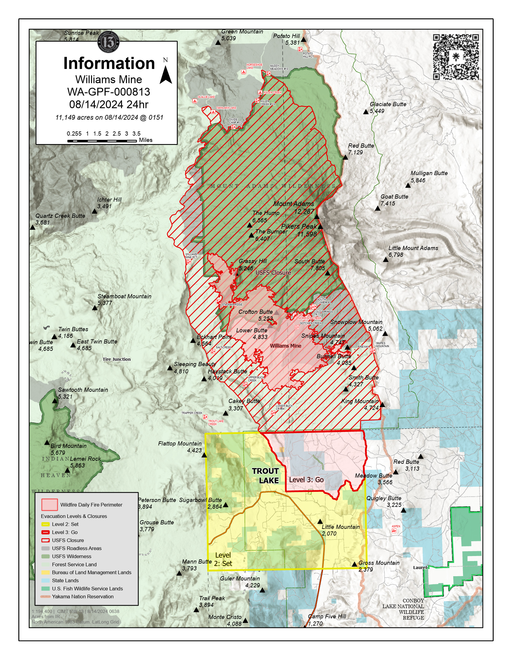
Williams Mine Fire Update 08 14 2024
Related Incident: Williams Mine Fire-GPNF
Publication Type: News
Williams Mine Fire Update for Wednesday, August 14, 2024
KEY MESSAGES:
A community meeting will be held tomorrow, Thursday, August 15, at 7:00 pm. The meeting will be located at the Trout Lake Volunteer Fire Department, 2415 WA-141, Trout Lake, WA 98650. This meeting will be recorded and posted to the Williams Mine Fire Facebook for those unable to attend.
Firefighters continue to be successful with suppression action limiting fire progression spread to the south, in an effort to protect the community of Trout Lake.
CURRENT STATUS:
Firefighting efforts will also be focused on the southeast flank of the fire, from the 8040 and 8020 roads as control lines have been assessed and implementation of line construction has begun. On the northeast side of the perimeter, firefighters are digging handline, engaging the fire directly with mechanical line construction following up in support of these developed lines. On the east side of the fire, crews are nearing completion of containment lines around Snipes Mountain. From Snipes Mountain they will be working towards the historic Cascade Creek Fire lines and anchoring lines to the natural lava beds at the base of Mount Adams.
Firefighters are continuing operations upon an anchor point established earlier in the week on the southern perimeter of the fire from the Mt. Adams to Wicky Creek. This line has allowed crews to safely achieve primarily direct containment on the 8040 road system to the Buck Creek drainage. Dozers continue to place indirect line west of Cascade Creek towards the Williams Mine Fire perimeter and the Cascade Creek burn scar. When connecting line construction across Cascade Creek, handline will be utilized to mitigate impacts from heavy equipment in the riparian areas.
Aviation resources, including fixed and rotor wing, are working to slow perimeter progression in priority containment areas of the fire. Yesterday, aerial fire efforts had good visibility due to lower levels of smoke volume and fire managers used these conditions to aid ground resources. These priorities include the south and southeast corner towards Trout Lake, the east towards the Yakama Nation and the western perimeter towards the 23 road.
WEATHER / FIRE BEHAVIOR:
Winds will relax as temperatures begin to warm today. This allows for the potential of increased instability in the afternoon and could develop vertical lift generating a higher smoke output. For Thursday, there will be a chance for thunderstorms near the fire with additional chances potentially this weekend that may have the ability to produce some rain showers.
SAFETY AND CLOSURES:
Scooper planes continue to dip out of Swift Reservoir and the Columbia River between Memaloose Island and Lyle, Washington. Members of the public and recreators should be aware that scooper planes could approach and dip out of these water sources at any time as weather conditions allow for aviation operations.
Washington DNR managed lands near Trout Lake and Glenwood are closed to entry due to the Williams Mine fire. For more information, please see http://www.dnr.wa.gov/ahtanum. The Confederated Tribes and Bands of the Yakama Nation, Tract D Recreation Area is closed, please see Yakama Tract D Road Closure for more information. Level 2 & 3 evacuations are in effect for the community of Trout Lake, and parts of Klickitat County. An evacuation center is located at 1455 NW Bruin County Road, White Salmon, Washington. Evacuations are coordinated through the Klickitat County Sheriff’s Office and the Skamania County Sheriff’s Office. The FS-23 and FS-25 roads are closed, see the Williams Mine Area and Road Closure for more details. The Pacific Crest Trail (PCT) is closed from the PCT's intersection with FS 23 to Potato Hill. The current area closure spans the entire Mt. Adams Wilderness.
WEST MOUNTAIN COMPLEX Wolf Creek Fire Update 08 14 2024
Related Incident: Wolf Creek Fire
Publication Type: News
**WEST MOUNTAIN COMPLEX: Wolf Creek Fire Update 08-14-2024**
Activity remains slow and minimal. Resources, such as crews, are being shifted to the Snag Fire. Containment continues to increase as firefighters focus on reinforcing control lines and mopping up. Containment is now at 61%. Firefighters continue the tedious work of coldtrailing--carefully inspecting and feeling the ground near the fire line to detect, dig out, and extinguish any remaining smoldering areas that could reignite. As fire activity diminishes here, crews will be shifted from the Wolf Creek Fire to the Snag Fire.
Black Canyon Fire Daily Update 08 14 2024
Related Incident:
Publication Type: News
Key Message
Crews found many spot fires yesterday, which has made lining the fire’s perimeter a slower process than planned. Helicopters have been vital in keeping the northern edge of the fire from spreading up slope by providing water bucket drops. Crews continue to keep the fire from advancing across the Smith River.
Current Status
On-the-ground mapping conducted early yesterday morning provided a more accurate perimeter of the fire area, including a reduction in acreage, and a better opportunity for crews to directly attack the fire. Yesterday, crews worked diligently, digging direct lines in all divisions. Helicopters used water on the northern end of the fire where it was most active, slowing the spread and creating time for crews to safely engage. New contingency dozer line was put in from the main road to the fire’s edge. Another reconnaissance flight is scheduled for today to identify potential new sources of heat.
The same approach of full suppression and integrating lines around the fire is the mission for today. Adding more crews into the different areas of the northeastern side of the fire will aid in slowing progression up the slope where the fire seems to be most active. Crews will start “mop-up” operations, extinguishing or removing any burning material near the control line, and adding more hose lay along the lower and eastern portions of the fire where hand line has been completed.
Weather and Fire Behavior
The weather forecast for Wednesday is partly sunny with showers throughout the day and a chance of thunderstorms in the afternoon. Expect southwest winds around 5 mph shifting to the northwest in the afternoon. Ridgetop winds will be northwest at 10 mph.
Battle Mountain Complex Daily Update 08 14 2024
Related Incident: Battle Mountain Complex
Publication Type: News
Roads begin to reopen and evacuation levels reduced again
Total Complex Estimated Acres: 182,870
Location: Ukiah, Oregon
Cause: Under Investigation
Personnel: 1017
Containment: 87%
Estimated Cost: $66 million
Resources: 22 crews | 36 engines | 3 helicopters | 25 water tenders | 18 dozers
Highlights: Crews removed nearly 35,000 feet of hose from the southwest side of the Battle Mountain Complex.
Operations: While containment has steadily increased, over 1,000 personnel work each day to mop up the remaining hotspots, remove unneeded equipment and repair any damage caused during the height of the suppression effort. 434 miles of fire line was constructed to contain the Battle Mountain Complex. Repairing this fireline is expected to take a while, but crews are focusing on the highest priority repairs.
Firefighters and equipment operators are repairing fences, firelines, stream crossings, and landings according to the standards provided by local government agencies. As the work is completed, it is inspected by local resource advisors for approval. Once it is approved, they move on to the next priority repair.
County officials continue to reassess evacuations and public lands are reopening in many areas. The Bureau of Land Management rescinded their closure order in the John Day River corridor from Service Creek to Kimberly and Kimberly to Monument. However, vegetation is still extremely dry and there are still fire restrictions. The potential for new fire starts is high and anyone recreating on public lands should stay informed about local fire restrictions.
The public can expect to see more firefighters and equipment parked along roadways. With heavy equipment coming off the fire there may be increased traffic. Please pass with caution and be alert for large trucks on blind corners.
Weather: Today will be mostly sunny and hazy with highs in the 80s and 90s. Partly to mostly cloudy skies arrive on Thursday with a 60 percent chance of rain and a 40 percent chance of lightning. However, not much measurable precipitation is expected. Cooler temperatures are expected tomorrow night as a cold front moves into the region.
Smoke: Smoke has moderated but is expected to persist from regional fires in the area. Residents can expect to continue to see smoke from interior pockets of unburned fuel. To see a detailed smoke outlook visit: https://linktr.ee/battlemntcomplex2024
Public Land Closures: Both the Bureau of Land Management and U.S. Forest Service have either rescinded or reduced closure orders for public lands. Visit https://linktr.ee/battlemntcomplex2024 for more information.
Road closures and fire restrictions: https://linktr.ee/battlemntcomplex2024
Grant, Morrow and Umatilla County Evacuations: https://linktr.ee/battlemntcomplex2024
West Mountain Complex Updated Closures 08 12 2024
Related Incident: Wolf Creek FireBoulder FireDollar Fire
Publication Type: Closures
BOISE, Idaho, Aug. 12, 2024 – The Boise National Forest has modified or expanding their wildfire closures to address public and firefighter safety and respond to increased wildfire growth. Changes became effective earlier today.
Please refer to the maps and closure orders on the Boise National Forest’s Alerts and Notices webpage and Interactive Forest Closure Map for specific details.
Bulltrout Fire: Due to successful firefighting efforts, the closure area is being reduced to the existing fire perimeter. Bulltrout Campground is now open, though the first-come, first-served campsites 11-15 are closed due to fire equipment.
Anderson, Bulldog, and Nellie Combined Fires: This new closure includes and expands upon the existing Bulldog and Anderson/Nellie Closure Order, and now includes an area around the Goat Fire, located two miles southeast of East Mountain.
This new closure area begins at the south end of the Snag fire closure area and continues south to Crouch and the Banks-Lowman Hwy, and east to the 579, 563 and 582 roads.
The 579, 563 and 582 roads will remain open, but all roads, trails and campgrounds within the closure area, include Deadwood Reservoir, are closed. An exception is the Deadwood Campground, located along the north side of the Banks-Lowman Hwy, will remain open.
Wapiti Fire: A new order expands the previous closure area. The closure effects some trails accessed from the Sawtooth Wilderness and road 524 into Grandjean.
The Boulder, Flat, Dollar/Oro (Snag) fire closure orders: No change
Reminder: The Boise National Forest is currently in Stage I Fire Restrictions. These restrictions are in place to protect public safety and natural resources by reducing the risk of human-caused wildfires during periods of high fire danger and severe fire weather conditions.
Daily Fire Update and Map 08 14 2024
Related Incident: Ruby Fire
Publication Type: News
Ruby Fire Update
August 14th, 2024
Minnesota Incident Command System (MNICS) Incident Commander-Jeb Backe
Ruby Fire Quick Facts
Size: 739 acres
Location: North Cascades National Park, Ruby Mountain, Diablo, Washington
Containment: 0% Cause: Lightning/Natural
Start Date: August 9th, 2024 Total Personnel: 71
Fire Information:
Inciweb: https://inciweb.wildfire.gov/incident-information/wancp-ruby-fire
Email: 2024.Ruby@firenet.gov
Facebook: https://www.facebook.com/people/Ruby-Fire/61563760546137
Phone: 1-360-208-8096
Current Status: Continued cloud cover with higher humidity levels and light winds minimized fire activity and spread yesterday. Firefighters continued structure protection to bridges, campgrounds, and trails, in addition to checking closed trails for public. Access is difficult due to steep terrain and hazards. Fire is burning in timber and brush.
Planned Actions: Firefighters will continue to protect values at risk surrounding the current fire area through structure protection to nearby infrastructure and natural resources, preparing for the potential of fire spread and growth. Main objectives are protecting human life, keeping fire away from values at risk, and minimizing wildfire spread to the north and west of the current fire location. Additional resources will be brought in as they become available.
Weather: NWS IMET – Slight chance for rain showers between 1 pm and 10 pm, with a chance of precipitation at 5 percent. Otherwise, cloudy becoming partially sunny with high of 73. West winds 2-5 mph. Mostly cloudy in the evening with a low of 60. East winds 1-3 mph. There is the risk of isolated thunderstorms in the fire area this week and weekend.
Closures: There are multiple closures in the area due to the Ruby Fire and other nearby fires. Colonial Creek South Campground and boat launch are closed. For a full list of park closures visit https://go.nps.gov/fireclosures . State Route 20 is closed east of the park from MP 148 and MP 157 due to the Easy Fire.
Burning Restrictions: National Park Service - Campfires or the ignition of wood, briquettes, or any fuel in fire pits, fire pans and barbeque grills, are banned in all portions of North Cascades National Park Service Complex – North Cascades National Park, Ross Lake National Recreation Area, and Lake Chelan National Recreation Area. This includes all National Park Service lands and campgrounds along State Route 20 as well as Hozomeen and the entire Stehekin Valley.
Cooperating Agencies & Tribes: National Park Service, Seattle City Light, Upper Skagit Indian Tribe, Whatcom County, Whatcom County Sheriff’s Office
Smoke: U.S. Interagency Wildland Fire Air Quality Response Program - Overall air quality will be MODERATE today in upper Skagit Valley. https://outlooks.wildlandfiresmoke.net/outlook/f79a6d6d https://www.airnow.gov/
If you would like to sign up for our daily updates, please send an email to: 2024.Ruby@firenet.gov
Willamette Complex South Daily Update Wednesday 08 14 2024
Related Incident: Willamette Complex Fires - South
Publication Type: News
Wednesday, August 14, 2024
Total Willamette Complex South Personnel: 759
Total Willamette Complex South Acres: 12,668
Resources: 24 Type 6 Engines, 11 Dozers, 12 Masticators, 2 Skid Steers
Fire Cause: Lightning
Community Meeting
There will be a community meeting for the Willamette Complex Fires South held on Friday, August 16th at 6:30 pm at the Banner Bank Amphitheater in Greenwaters Park in Oakridge, OR. This in-person meeting will be recorded and posted to Facebook and YouTube.
Summary
Firefighting crews have made progress strengthening containment lines on the Willamette Complex South fires. Recent favorable weather conditions have aided their efforts.
Chalk Fire (5,449 acres, 54% containment)
A downed tree created a spot fire across Forest Road 1920 on the southwest corner of the Chalk Fire. Firefighters with hand tools contained the fire by the end of the day.
Coffeepot Fire (6,078 acres, 35% containment)
Crews are making significant progress to secure the southern edge of the Coffeepot Fire. They are removing hazard trees and mopping up by extinguishing heat along the fireline.
Moss Mountain Fire (754 acres, 0% containment)
Firefighters and heavy equipment operators are securing line to contain the stringer of fire that crossed Forest Road 2120 to the south. Crews are making good progress along Forest Roads 2120 and 23 to head off any potential spread.
208 Fire (202 acres, 0% containment)
The 208 Fire continues to smolder and creep but has shown minimal growth beyond its perimeter. Fire managers are evaluating strategies to control the fire.
217 Fire, Tire Mountain Fire, and McKinley Fire
The 217, Tire Mountain, and McKinley fires are 100% contained and crews are monitoring status regularly.
Weather and Fire Behavior
Temperatures remained about the same with variable cloud cover over the fire area. Winds are consistently from the west and northwest, and the marine layer is expected to move in again later this week. Moderate fire behavior is expected, with smoldering, creeping, and isolated torching.
Closures and Fire Restrictions
Area, road, trail, and recreation site closures are in place on the Willamette National Forest in the vicinity of many active fires. Temporary road barricades are in place to restrict traffic across the fire areas.
- For specific closure information visit tinyurl.com/WillFireClosures2024
- For current fire restrictions visit tinyurl.com/WillFireRestrictions2024
Temporary Flight Restrictions (TFR) are in place over the Chalk, Coffeepot, and Moss Mountain Fires. Visit tfr.faa.gov for up-to-date areas. Wildfires are a no-fly zone for unauthorized aircraft, including drones. For more information, visit knowbeforeyoufly.org.
For More Information
Phone: (541) 208-1742, 8 a.m. to 8 p.m.
Email: 2024.willamettecomplex@firenet.gov
InciWeb: https://inciweb.wildfire.gov/incident-information/orwif-willamette-complex-fires-south
Facebook: https://www.facebook.com/WillametteComplexFires
YouTube Channel: https://www.youtube.com/@WillametteComplexFiresSouth
Grouse Fire Daily Update 08 14 2024
Related Incident: Grouse
Publication Type: News
Incident Commander: Bill Waln, Incident Commander
Location: 10 miles southwest of Wise River, MT
Start Date: 7/25/2024
Cause: Undetermined
Size: 4,166 acres
Containment: 22%
Resources on Site: 1 Type 2 hand crews; 1 Type 2 Initial Attack crew; 6 engines; 1 skidgens; 1 dozer
Total Personnel: 212
KEY MESSAGES
Traffic along the Pioneer Scenic Byway will continue to include log and dump trucks throughout the day as they haul logs and debris from the shaded fuel breaks. Firefighters are still working along the Byway piling limbs and debris, and cleaning up the area. It’s evident everyone appreciates the work our firefighters have done to fight the Grouse Fire, and we ask that you help us keep our firefighters safe by slowing down as you drive along the Byway between Wise River and south of the Pettengill area.
An infrared flight (IR) over the fire confirmed that this fire is not out. Areas of heat showed up on the IR map inside the fire perimeter southwest of Grouse Lakes, and inside the north and central part of the fire. Isolated hot spots remain throughout the interior of the fire.
Current Status/PLANNED ACTIONS
Firefighters will continue to work containment lines as they patrol the fire and mop up any hot spots. They will also continue to reinforce constructed fire lines that are yet not fully contained.
Cleanup along the Pioneer Mountains Scenic Byway will continue over the next several days.
The structure protection group will haul in and package up the last of the pumps, sprinklers, hose, and other materials that were put in place around structures in the Pettengill Road area. As they work, they will return the residential areas back to their pre-fire state.
Weather and Fire Behavior
It will be a little warmer and drier today over the fire. Temperatures will range from the low 60s to mid 70s and the humidities between 27 and 35 percent. Winds from the west this morning will shift to the northwest this afternoon from 3-8 mph in the slopes, valleys, and Wise River drainage. Wind will range from 6-10 mph with gusts up to 16 mph after noon today. A chance of thunderstorms this afternoon could bring wind gusts at 40 mph.
CLOSURES AND RESTRICTIONS
The Beaverhead-Deerlodge National Forest has issued an Area/Road/Trail Closure (Closure #01-02-03-24-05) effective July 31, 2024. This Order is for public and firefighter safety during fire suppression efforts of the Grouse Fire. Closure information and maps are posted on the Forests’ website and the fire’s Inciweb page as they are in place. https://inciweb.wildfire.gov/incident-information/mtbdf-grouse.
A Temporary Flight Restriction (TFR) is in place over the fire area.
The Forest is in Stage 1 Fire Restrictions. Campfires are allowed only in a permanent metal fire grate/ring provided by the Forest Service in a designated, developed recreation site. Smoking is restricted to vehicles, in buildings, or in an area clear of flammable materials. Devices with an on/off switch that use LPG fuels are allowed in an area clear of flammable materials within three feet of the device.