
2024 SQF Lightning Daily Incident Update 08 14 2024
Related Incident: 2024 SQF Lightning
Publication Type: News
Incident Update
Borel Fire/SQF Lightning Fires
Wednesday, August 14, 2024
Fire Information: 559-481-7849, 9 a.m. to 7 p.m.
Media Line: 559-492-9967, 9 a.m. to 7 p.m.
Email:2024.borel@firenet.gov
Linktree: linktr.ee/2024sqflightning
Borel Fire: 59,288 Acres | 91% Contained Trout Fire: 23,597 Acres | 70% Contained
Total Personnel: 867 Long Fire: 9,204 | 98% Contained
Borel Fire: https://inciweb.wildfire.gov/incident-information/casqf-borel-fire
SQF Lightning: https://inciweb.wildfire.gov/incident-maps-gallery/casqf-2024-sqf-lightning
Current Situation: We want to thank the New York City Fire Department Type 3 Incident Management Team for their efforts managing the SQF Lightning Fire over the past weeks. This morning, the team managing the Borel Fire (CA Interagency Incident Management Team 2) have assumed command of the Trout Fire and Long Fire. Fire activity is minimal, and is not posing a threat to additional growth. Fire suppression repair activities continue.
Borel Fire: Firefighters are still on high alert for potential new fires that start in the immediate area and are ready for a rapid response. Burned Area Emergency Response (BAER) teams have arrived and will begin to determine the need for and to prescribe and implement emergency treatments to stabilize and prevent unacceptable degradation to natural and cultural resources. We encourage residents re-entering the area to proceed with caution to avoid unseen hazards caused by the fire, and help maintain the safety of repair crews working in the area.
Trout Fire: The fire continues to smolder and move slowly uphill in steep terrain. Crews will construct several miles of fire line to increase containment. Fire suppression repair operations continue in the fire area.
Long Fire: This fire is 98% contained, and nearly all Long Fire personnel have been reassigned to Trout or Borel. The area is being monitored, there is no threat, and no changes are expected.
Sequoia National Forest & BLM Closures & Restrictions: The Borel Fire Piute Mountains Area Closure begins at the northwest corner of Section 30, Township 27 South, Range 33 East, Mount Diablo Base and Meridian, then continues approximately 47 miles around the Sequoia National Forest Boundary to the starting point. All orders, maps, and accompanying appendices can be found on the Forest’s website: tinyurl.com/2en2d36k.
The Bureau of Land Management Bakersfield Office is lifting the emergency closure of the Creek Campground, a portion of the Pacific Crest Trail, and Canebrake Road in Tulare County. The closures were in place for public and firefighter safety in relation to the management of the SQF Lightning Complex Fire and are no longer necessary due to the lack of fire progression. The closures are lifted as of Tuesday, August 13. Long Valley Campground and Long Valley Loop road remain closed. View the emergency closure order here: https://tinyurl.com/5n8rxcxh.
Road Closures: Sherman Pass Road is closed from Mountain Highway 99 to the Blackrock Information Center. Visit the Kern County Public Works Department website for the additional information on county road closures (tinyurl.com/z6crvp6t)
Evacuations: All Borel Fire evacuations have been lifted. Everyone in areas of active fires should “Know Your Zone.” Go to Genasys Protect (tinyurl.com/jcdv55f9) to identify the zone you reside in.
Pincer Two Fire Daily Update 08 14 2024
Related Incident: Pincer Two Fire
Publication Type: Announcement
11:00 AM, August 14, 2024
Estimated size: 189 acres
Start Date/Time: July 17, 2024
Area of Origin: Johannesburg Mountain. 1 Mile East of Mineral Park C.G.
Cause: Lightning
Fuels/Topography: Timber, rugged terrain
Structures Damaged: None, there are no homes threatened at this time.
Evacuations: None
Closures: Cascade River Road at and including Marble Creek Campground, Mineral Park Campground, and all tributary roads, trailheads, and trails are all closed. The public is not to enter the area for public and firefighter safety.
Full closure orders available at: https://www.fs.usda.gov/mbs
Update: Minimal fire activity occurred yesterday, with continued cool weather conditions and high relative humidity, and the fire continues to hold at the 50-foot mark above the road. Firefighters are continuing to patrol along the road for snags, rolling debris, and any new hot spots.
Weather: Dry and slightly warmer conditions today although humidities remain high with excellent overnight recoveries. There's a chance of afternoon showers on Thursday with thunderstorm chances closer to the Cascade crest. Sunny, max temperatures around 72. Light winds becoming west 5 to 6 mph in the afternoon.
Smoke: For more information on smoke and air quality please visit: https://wasmoke.blogspot.com/
Air Space Restrictions: There are no air space restrictions at this time.
Forest Restrictions: The Mt. Baker-Snoqualmie has a full campfire ban and forest-wide shooting restrictions in place to help prevent human-caused starts during this period of unprecedented resource scarcity. Additional details at: www.fs.usda.gov/mbs
###
2024 Borel Fire Daily Incident Update 08 14 2024
Related Incident: Borel Fire
Publication Type: News
Incident Update
Borel Fire/SQF Lightning Fires Wednesday, August 14, 2024
Fire Information: 559-481-7849, 9 a.m. to 7 p.m. Media Line: 559-492-9967, 9 a.m. to 7 p.m. Email: 2024.borel@firenet.gov
Linktree: linktr.ee/2024sqflightning
Borel Fire: 59,288 Acres | 91% Contained Total Personnel: 867
facebook.com/SequoiaNF/ x.com/SequoiaForest
Trout Fire: 23,597 Acres | 70% Contained Long Fire: 9,204 | 98% Contained
Borel Fire: https://inciweb.wildfire.gov/incident-information/casqf-borel-fire
SQF Lightning: https://inciweb.wildfire.gov/incident-maps-gallery/casqf-2024-sqf-lightning
Current Situation: We want to thank the New York City Fire Department Type 3 Incident Management Team for their efforts managing the SQF Lightning Fire over the past weeks. This morning, the team managing the Borel Fire (CA Interagency Incident Management Team 2) have assumed command of the Trout Fire and Long Fire. Fire activity is minimal, and is not posing a threat to additional growth. Fire suppression repair activities continue.
Borel Fire: Firefighters are still on high alert for potential new fires that start in the immediate area and are ready for a rapid response. Burned Area Emergency Response (BAER) teams have arrived and will begin to determine the need for and to prescribe and implement emergency treatments to stabilize and prevent unacceptable degradation to natural and cultural resources. We encourage residents re-entering the area to proceed with caution to avoid unseen hazards caused by the fire, and help maintain the safety of repair crews working in the area.
Trout Fire: The fire continues to smolder and move slowly uphill in steep terrain. Crews will construct several miles of fire line to increase containment. Fire suppression repair operations continue in the fire area.
Long Fire: This fire is 98% contained, and nearly all Long Fire personnel have been reassigned to Trout or Borel. The area is being monitored, there is no threat, and no changes are expected.
Sequoia National Forest & BLM Closures & Restrictions: The Borel Fire Piute Mountains Area Closure begins at the northwest corner of Section 30, Township 27 South, Range 33 East, Mount Diablo Base and Meridian, then continues approximately 47 miles around the Sequoia National Forest Boundary to the starting point. All orders, maps, and accompanying appendices can be found on the Forest’s website: tinyurl.com/2en2d36k.
The Bureau of Land Management Bakersfield Office is lifting the emergency closure of the Creek Campground, a portion of the Pacific Crest Trail, and Canebrake Road in Tulare County. The closures were in place for public and firefighter safety in relation to the management of the SQF Lightning Complex Fire and are no longer necessary due to the lack of fire progression. The closures are lifted as of Tuesday, August 13. Long Valley Campground and Long Valley Loop road remain closed. View the emergency closure order here: https://tinyurl.com/5n8rxcxh .
Road Closures: Sherman Pass Road is closed from Mountain Highway 99 to the Blackrock Information Center. Visit the Kern County Public Works Department website for the additional information on county road closures (tinyurl.com/z6crvp6t)
Evacuations: All Borel Fire evacuations have been lifted. Everyone in areas of active fires should “Know Your Zone.” Go to Genasys Protect (tinyurl.com/jcdv55f9) to identify the zone you reside in.
Cottage GroveLane 1 Fire Update 08 14 2024
Related Incident: Lane 1 Fire
Publication Type: News
Warmer, windy weather prompts small spot fires on Lane 1 Fire
COTTAGE GROVE, Ore. – Warmer weather returned across the Lane 1 Fire on Tuesday, bringing the potential for increased fire activity. A small spot fire, estimated to be six acres was found off a southeast portion of line yesterday afternoon. In the windy conditions, it continued to spot uphill, creating multiple smaller fires. Firefighters continued to work in these areas into the evening, however fog and extremely high relative humidity are making it difficult to determine where some of the smaller fires are located. When temperatures begin to rise later today, smoke will help firefighters determine where these remaining hot spots are, with a goal of lining all of these spots as quickly as possible.
Along the majority of the north and west side of the fire perimeter, mop-up operations continued yesterday and overnight. Higher relative humidity has been beneficial to firefighters dedicated to this work, and as a result, containment has increased to 26%.
The resources that have been engaged on the Lane 1 Fire range from contracted firefighters, engines, and bulldozers to industrial heavy equipment and machinery provided by private landowners and companies, as well as local, state and federal firefighting agencies. Each has contributed to the ongoing effort in suppressing the fire. With the majority of line constructed, some industrial equipment is being demobilized from the fire. ODF Team 1 is appreciative of the collaborative efforts that were made by these entities.
As progress continues to be made, resources will continue to be demobilized from the incident, or strategically placed elsewhere on the fire where additional work is needed.
Closures: Due to the wildfires, the Umpqua National Forest has issued three closures impacting every district of the forest. Cottage Grove Ranger District is closed. Closure Orders and maps can be found here: https://www.fs.usda.gov/alerts/umpqua/alerts-notices.
The Bureau of Land Management has issued the following emergency closure for Lane County: https://www.blm.gov/announcement/bureau-land-management-expands-emergency-fire-closure-due-cottage-grove-lane-1-fire
The following County roads are closed except to owners of private lands accessed from these roads: Brice Creek Road east of Umpqua National Forest Boundary, all of Sharps Creek Road.
Evacuations: A “Level 3” evacuation notice is in effect for the Bohemia Mining District and Fairview Peak. Additionally, a “Level 1” evacuation notice has been issued by the Lane County Sheriff’s Department for areas east of Disston, starting at Brice Creek Road milepost 0.7 and following Brice Creek Road south. An evacuation map is available at: www.LaneCountyOR.gov/Lane1Fire.
Temporary Flight Restriction (TFR): A “TFR” is in place at an altitude from the surface up to and including 8500 feet, daily (24 hours) until further notice. Complete information is available at https://tfr.faa.gov/save_pages/detail_4_5180.html. Flying a drone near or around a wildfire compromises the safety of pilots and interferes with firefighting efforts.
Fire Restrictions: Umpqua National Forest restrictions can be found online – https://www.fs.usda.gov/main/umpqua/fire
Oregon Department of Forestry restrictions can be found here – https://www.oregon.gov/odf/fire/pages/restrictions.aspx
Douglas Forest Protective Association restrictions can be found here – https://www.dfpa.net/public-fire-restrictions
Actualizacin Matutina del Incendio Retreat 14 de Agosto 2024 08 14 2024
Related Incident: Retreat
Publication Type: News
Actualización Matutina del Incendio Retreat - 14 de Agosto 2024
Información sobre incendios: 509-213-4890, de 8 a.m. a 8 p.m.
Correo electrónico 2024.Retreat@firenet.gov
Linktree: linktr.ee/CIIMT14
Acres totales: 45.601 acres Contención: 70% Cantidad de personal: 372
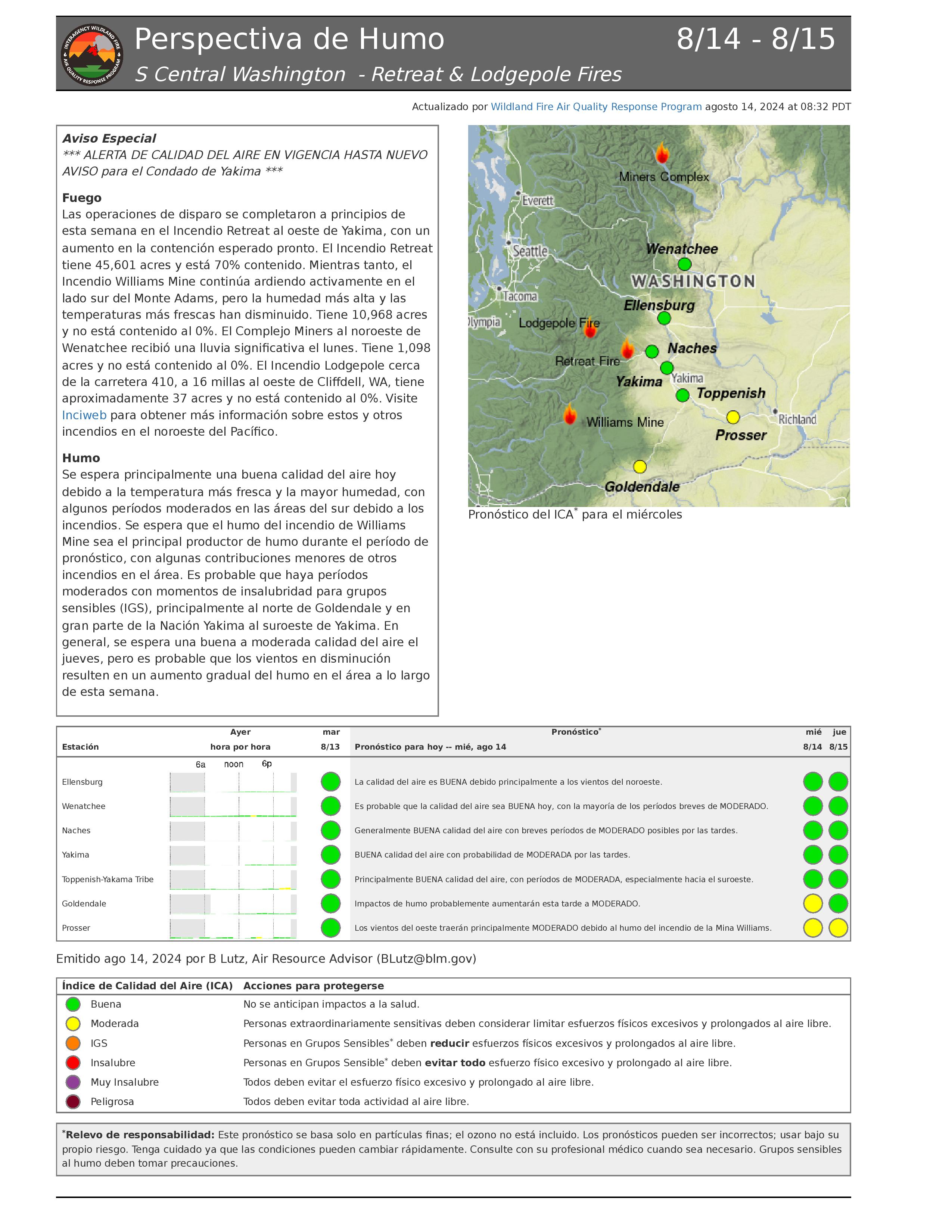
Situación actual: Los bomberos continúan asegurando, limpiando y patrullando las líneas de fuego alrededor del Retreat Fire y están finalizando una línea de control alternativa (ruptura de combustible sombreada) a lo largo de las carreteras forestales 1200 y 1201 para proteger las estructuras en el área de Rimrock Lake. Están empezando a talar árboles peligrosos a lo largo de los sistemas de carreteras internas para permitir un mayor acceso a través del incendio y patrullar el perímetro del incendio. Las cuadrillas están retirando los equipos y mangueras innecesarios de la línea de fuego y comenzando la reparación de la extinción del incendio (nivelación de carreteras, tala de árboles peligrosos y reparación de la línea de dozer) donde están seguros de que el incendio está totalmente contenido. Algunos recursos de extinción de incendios (equipos, motores, tripulaciones) se están desplazando al incendio Lodgepole cerca de la zona de acampar Lodgepole en la autopista 410.
A lo largo de la autopista estatal 12, los equipos del Departamento de Transporte de Washington están trabajando para reemplazar los guardarraíles y señales dañados por el fuego, ya que esta autopista sigue siendo una prioridad para que pueda ser abierta, y las órdenes de evacuación levantadas tan pronto como sea posible.
El objetivo de control del incendio del Retiro es mantener el fuego contenido dentro de los elementos de control naturales y construidos, dando prioridad a la seguridad pública y de los bomberos.
El tiempo: Con una vaguada de baja presión acercándose hoy a la costa oeste, mas tarde los vientos cambiarán y empezarán a venir del sureste. Los vientos se moderarán en comparación con los último par de días. Hay pocos cambios en la humedad mínima (30-40%) y las temperaturas (mediados de los 60) sobre la zona del incendio con respecto a ayer.
Evacuaciones: Para obtener la información más actualizada sobre evacuaciones, visite el sitio web de Administración de Emergencias del Condado de Yakima en yakimacounty.us/350.
Cierres por incendio:
- La US Highway 12 permanece cerrada entre la Y de la Highway 410 y la cima del puerto en el punto kilométrico 151.
- Okanogan-Wenatchee National Forest Retreat Fire Closure(tinyurl.com/5ext5aec).
- La Región Sureste del Departamento de Recursos Naturales del Estado de Washington (DNR) ha cerrado temporalmente parte del Bosque Estatal de Ahtanum. El público puede acceder a la información más actualizada sobre el cierre en dnr.wa.gov/ahtanum.
- El Departamento de Pesca y Vida Silvestre de Washington ha cerrado al acceso público la mayor parte de la zona silvestre de Oak Creek debido al incendio Retreat Fire hasta el 23 de agosto de 2024. Más información en tinyurl.com/bdet7845.
Calidad del aire y humo: En airnow.gov puede consultar las previsiones sobre la calidad del aire y el humo.

Informacin diaria del incendio de Lodgepole 14 de agosto de 2024 08 14 2024
Related Incident: Lodgepole
Publication Type: News
Información diaria del incendio de Lodgepole - 14 de agosto de 2024
Teléfono: 559-481-7849, de 8 a 20 h.
Correo electrónico 2024.Lodgepole@firenet.gov
Información sobre incendios: linktr.ee/CIIMT14
Hectáreas: 5
Contención: 0%
Situación actual: A partir de las 6:00 p.m. del 13 de agosto de 2024, el Equipo Interagencial de Manejo de Incidentes 14 de California ha asumido el mando del Incendio Lodgepole. Actualmente el fuego se estima ser 5 acres y sigue ardiendo en Norse Peak Wilderness, al norte de la autopista 410 cerca del Lodgepole Campground, situado en el Okanogan-Wenatchee National Forest.
Actualmente el Lodgepole Fire se encuentra a aproximadamente ½ milla al norte de la autopista 410 y quema dentro de la cicatriz quemada de Norse Fire que está lleno de árboles peligrosos en pie y grandes escombros derribados. El terreno es también muy accidentado y escarpado, lo que plantea dificultades a los bomberos para acceder a él. El fuego está amenazando varias cabañas de propiedad privada en extensiones cercanas de cabañas de residencia recreativa del Servicio Forestal junto con el Camping Lodgepole.
Los bomberos y los aviones se han dedicado a iniciar las labores de extinción desde que se informó del incendio el lunes por la tarde. Las cuadrillas han accedido al incendio, han iniciado la construcción de líneas de fuego directas y han comenzado a tomar precauciones para proteger las estructuras que actualmente están amenazadas. Hoy, los bomberos trabajarán para construir una línea directa y comenzar a anclar el borde sur para evitar una mayor propagación hacia la autopista 410. La gran cantidad de árboles peligrosos y material muerto en la zona constituyen un importante problema de seguridad para los bomberos. Las cuadrillas están teniendo que retirar estos árboles peligrosos a medida que acceden para construir sus líneas de control. Las cuadrillas también siguen trabajando para evaluar y despejar las zonas alrededor de las estructuras amenazadas. Los aviones seguirán ayudando a los equipos de tierra hoy si el tiempo lo permite.
En este momento la autopista 410 permanece abierta a la circulación. Por favor, tenga cuidado en la zona debido a los impactos de humo, así como los bomberos y equipos de emergencia que trabajan a lo largo de la carretera.
El tiempo: Con una vaguada de baja presión acercándose hoy a la costa oeste, mas tarde los vientos cambiarán y empezarán a venir del sureste. Los vientos se moderarán en comparación con los último par de días. Hay pocos cambios en la humedad mínima (30-40%) y las temperaturas (mediados de los 60) sobre la zona del incendio con respecto a ayer.
Calidad del aire y humo: Las perspectivas sobre la calidad del aire y el humo pueden consultarse en airnow.gov.
Pioneer Fire Update 08 14 2024
Related Incident:
Publication Type: News
Pioneer Fire Daily Update August 14, 2024
Quick Facts
Size: 38,480 | Start Date: June 08, 2024
Location: 31 miles NW of Chelan, WA
Containment: 13 percent | Personnel: 610 | Cause: Human-caused, under investigation
CURRENT SITUATION: Yesterday on the ridgeline above Boulder Creek, firefighters utilized Very Large Air Tankers and Large Air Tankers to deliver retardant to the fire. Additionally, a Skycrane helicopter was used to supplement retardant drops on the fire line by precisely dropping retardant in spots identified by firefighters on the ground. Air crews will take advantage of the change in weather and moderate to low fire activity to increase containment of the Pioneer Fire. Air assets will deliver more retardant to the ridgelines near Boulder Creek and conduct water drops to provide direct support to handcrews working at the fires edge.
TODAY’S ACTIVITIES: Firefighters will continue hand line construction in the Boulder Creek and Rainbow Creek areas. Firefighters continue to evaluate the risks and impacts from the moisture and lightning received on August 12. Recent precipitation has moderated fire behavior and slowed spread, however, fire behavior will slowly increase as fuels dry. Rolling materials may affect the roadway between Rainbow and Little Boulder creeks. An overnight infrared flight showed scattered heat sources are still present in the upper Boulder Creek drainages.
WEATHER AND SMOKE: Breezy down lake winds will decrease in the morning, with Wednesday being the calmest weather day of the week. There is a 5% chance of showers, otherwise the day will remain mostly sunny. Temperatures will warm slightly with temperatures in the low 80s. Winds will be downlake in the morning, shifting to uplake in the early afternoon.
For smoke report: https://outlooks.airfire.org/outlook/f79a6d6d .
EVACUATIONS: Level 1, 2 and 3 evacuation levels remain in effect around the Pioneer Fire. Please contact Chelan County Emergency Management or visit https://t.ly/QoH9w for more information.
FOREST CLOSURE: Closures for the North Cascades National Park: https://www.nps.gov/noca/index.htm
The Okanogan-Wenatchee National Forest has a closure order in place for much of the fire area: Okanogan-Wenatchee National Forest - Alerts & Closures (usda.gov). Campfires are prohibited. There is a Temporary Flight Restriction (TFR) in place over the fire: https://tfr.faa.gov/save_pages/detail_4_6779.html. Unauthorized drone activity is prohibited under the TFR.
InciWeb: https://inciweb.wildfire.gov/incident-information/wases-pioneer
Facebook: https://www.facebook.com/profile.php?id=61560760893080
Fire Information Line: 541-861-5808, 8 AM to 8 PM
Email: 2024.pioneer@firenet.gov
Cougar Creek Fire Daily Update 08 14 2024
Related Incident: Cougar Creek Fire
Publication Type: News
Quick Facts
Size: 24,091 acres Start Date: July 15, 2024 Cause: Under investigation
Location: SW of Clarkston, 1 mile west of Hwy 129 and Grand Ronde River intersection
Containment: 60% Personnel: 353 Fire Strategy: Full suppression
Resources Assigned: 6 crews, 3 helicopters, 26 engines, 9 water tenders, 3 heavy equipment
The Cougar Creek Fire is burning within a mountainous and remote area on the Umatilla National Forest bordering the Wenaha-Tucannon Wilderness.
Operations: Up to a half inch of early morning rains and cooler temperature moderated fire behavior yesterday. Crews mopped up around the hand line and dozer line in the Saddle Butte area and continued to patrol fireline where previous firing operations occurred on the west and north perimeters of the fire. Firefighters dismantled water handling equipment, hose lays, and sprinkler systems around Misery Snow Park and the historic Wenatchee Guard Station and began structure wrap removal from buildings. A new lightning-caused fire was detected near the south end of the fire and was quickly extinguished by firefighters working in the area.
As of 7 p.m. last night, command of the fire transitioned to Northeast Washington Team 1 (Type 3 team).
Today, firefighters will continue mop-up operations along the west and northwest portions of the fire. On the south and east sides of the fire, crews will continue to backhaul remaining equipment and supplies. Fire managers will begin to assess fire suppression repair work to help mitigate long-term impacts to natural resources from fire suppression activities.
Evacuations and Closures: All evacuation orders have been lifted. Forest closure descriptions and maps are available online on the Umatilla National Forest closure website. Please respect area closure orders and use extra caution while driving for your safety as well as our firefighters.
Weather and Smoke: Mostly sunny with temperatures in the mid 70s to low 80s on Wednesday. Cooler temperatures and a chance of showers and thunderstorms will be likely by Thursday. Air quality in the region remains good. Learn more about smoke at http://wasmoke.blogspot.com/.
InciWeb: https://inciweb.wildfire.gov/incident-information/wases-cougar-creek-fire
Facebook: https://www.facebook.com/CougarCreekFire2024
Fire Information Line: 509-210-2928, 8 AM to 6 PM
Email: 2024.cougarcreek@firenet.gov
Easy Fire Update 08 14 2024
Related Incident: Easy Fire
Publication Type: News
Easy Fire Daily Update
August 14, 2024
Quick Facts
Size: 2130 acres | Start Date: July 17, 2024 | Location: 17 miles west of Mazama, WA
Containment: 0% | Cause: Lightning | Resources Assigned: 305
CURRENT SITUATION: Road crews with the Washington Department of Transportation (WSDOT) continue to remove debris from State Road 20 following the mudslide on Aug 11. The damage is more extensive than previously realized and more heavy equipment will be actively removing dirt and debris from the roadway. The WSDOT team will reevaluate the road closure on Monday, August 19. Firefighters will continue to seek opportunities to directly contain the southeast flank in the Swamp Creek drainage area.
TODAY: Recent precipitation has drastically moderated fire behavior with activity mostly confined to smoldering and creeping. The fire remains on the north side of Highway 20, burning in timber fuels on extremely steep slopes between Mebee Pass and Mount Hardy. Firefighters working along State Road 20 will continue improving containment lines along the roadway while removing any fallen trees and fire related debris.
WEATHER AND SMOKE: Today will remain dry and relatively calm across the fire area, with clouds and fog in the morning hours. Once the fog breaks, the day will become partly sunny with temperatures warming into the upper 70s and low 80s. Calm winds in the morning will increase to northwest winds up to 13 mph.
Read full smoke report: https://outlooks.airfire.org/outlook/f79a6d6d
CLOSURES: State Route 20 will remain closed between Granite Creek (MP 148) and Rainy Pass (MP 157) as crews continue working to mitigate hazards. https://wsdot.com/Travel/Real-time/Map/
The Okanogan-Wenatchee National Forest has closures in place for trails within the fire area: https://bit.ly/EasyFireClosures . This closure includes a portion of the Pacific Crest Trail. Campfires are prohibited.
There is a Temporary Flight Restriction (TFR) in place over the fire: https://tfr.faa.gov/save_pages/detail_4_6779.html Unauthorized drone activity is prohibited under the TFR.
EVACUATIONS: There are no evacuations in place for the Easy Fire. Visitors recreating in the area should be vigilant of surroundings and stay out of closed areas.
InciWeb: https://inciweb.wildfire.gov/incident-information/waowf-easy-fire
Facebook: https://www.facebook.com/profile.php?id=61560760893080
Fire Information Line: 541-861-5808, 8 AM to 8 PM
Email: 2024.easy@firenet.gov
Town Gulch Fire Daily Update 08 14 2024
Related Incident: Town Gulch
Publication Type: News
Town Gulch Fire Daily Update
Wednesday, August 14, 2024
Fire Information: 541-208-7092, 8 a.m. to 8 p.m.
Town Gulch Fire Facebook: tinyurl.com/ycypw2bt
Email: 2024.TownGulch@firenet.gov
Linktree: linktr.ee/TownGulchFire
Size: 18,188 acres Cause: Lightning
Containment: 62 percent Start Date: August 5, 2024
Total Personnel: 363 Structures Damaged or Destroyed: 4
CURRENT SITUATION: Firefighters will patrol and monitor the fire perimeter to ensure any unburned pockets of fuel do not reignite and threaten containment lines. Crews are also working on suppression repair. This involves repairing damage attributable to suppressing the fire. Activities include installing water bars and placing cut vegetation on dozer lines to prevent erosion, maintaining roads and repairing fences. Fire resources are also removing fire hose, pumps and water holding tanks from firelines so they can be refurbished and utilized on other fires.
As containment increases and the fire threat diminishes, the IMT is focused on rightsizing the organization. This is a delicate balance of maintaining the people and equipment needed to patrol the fire perimeter, complete all suppression repair activities and remove the infrastructure used to suppress the fire – while also releasing excess resources so they can be available for reassignment to other fires and initial attack throughout the western US.
WEATHER, FIRE BEHAVIOR & SMOKE: The fire received around a tenth of an inch of rain yesterday. The Incident Meteorogist has identified no weather threats to the fire today. Smoke impacts will be minimal today. Current air quality information is available on the Oregon smoke blog (https://www.oregonsmoke.org/).
CLOSURES: Wallowa-Whitman National Forest lands, roads, trails, and recreation sites around the Town Gulch Fire are temporarily closed and fire restrictions are in effect. Forest closure orders and maps can be found on the Forest’s “Forest Orders” web page: tinyurl.com/36t4f2t2.
EVACUATIONS: Baker County Sheriff’s Office has issued Level 1, 2, and 3 evacuations for areas near the fire. Follow the sheriff’s office Facebook page (tinyurl.com/3auvka4j) for the latest evacuation news. Residents may sign up to receive emergency notifications through Baker County ALERT (tinyurl.com/884czdrf).