
Coffeepot Fire Update 08 14 2024
Related Incident: Coffee Pot Fire
Publication Type: News
Size: 50 Acres
Containment: 0%
Fire Cause: Lightning
The Coffeepot Fire is currently 50 acres and burning slowly in steep and challenging terrain. This morning, fire spread along the southwestern perimeter as it entered into Bureau of Land Management jurisdiction. At this time the fire will continue to be managed by the National Park Service. Firefighters are actively addressing the spread with support from air resources, focusing on direct attack strategies to work towards full suppression. Additional resources have been mobilized to support firefighting efforts. While full containment will take time, there is no immediate threat to surrounding communities. Fire updates will be posted daily on the Coffeepot Fire InciWeb page.
Settings - change map background and toggle additional layers
Filter - control incident types displayed on map.
Zoom to your location
Reset map zoom and position
Could not determine your location.
Show Legend
 Wildfire
 Prescribed Fire
 Burned Area
Response
Burned Area
Response Other
Other
Broom Canyon Fire
Unit Information
Incident Contacts
Trout Fire Closure Forest Order No 05132417 08 12 2024
Related Incident: 2024 SQF Lightning
Publication Type: Closures
Pursuant to 16 U.S.C. § 551 and 36 C.F.R. § 261.50(a) and (b), and to provide for public safety, the following acts are prohibited within the Kern River Ranger District of the Sequoia National Forest. This order is effective from August 13, 2024 through August 15, 2024.
1. Going into or being upon any National Forest System lands within the Trout Fire Closure Area, as described in Exhibit A and shown on the attached map. 36 C.F.R. §261.52(e).
2. Being on any National Forest System Trail within the Trout Fire Closure Area, as described in Exhibit A and shown on the attached map. 36 C.F.R. § 261.55(a).
3. Being on any National Forest System Road within the Trout Fire Closure Area, as described in Exhibit A and shown on the attached map. 36 C.F.R § 261.54(e).
4. Entering or using any Developed Recreation Site within the Trout Fire Closure Area, as described in Exhibit A and shown on the attached map. 36 C.F.R. § 261.58(b)
Pursuant to 36 C.F.R. § 261.50(e), the following persons are exempt from this Order:
1. Any Federal, State, or local officer, or member of an organized rescue or firefighting force in the performance of an official duty.
2. Persons with Forest Service Permit No. FS-7700-48 (Permit for Use of Roads, Trails, or Areas Restricted by Regulation or Order), specifically exempting them from this Order.
3. Owners or lessees of land in the area, to the extent necessary to access their property.
These prohibitions are in addition to the general prohibitions in 36 C.F.R. Part 261, Subpart A. A violation of these prohibitions is punishable by a fine of not more than $5,000 for an individual or $10,000 for an organization, or imprisonment for not more than 6 months, or both. 16 U.S.C. § 551 and 18 U.S.C. §§ 3559, 3571, and 3581.
Executed in Porterville, California, this 12th day of August, 2024.
To view the full order, including a map, click the link below.
Borel Fire Breckenridge Mountains Area Trails and Roads Closure 08 13 2024
Related Incident: Borel Fire
Publication Type: Announcement
Pursuant to 16 U.S.C. § 551 and 36 C.F.R. § 261.50(a) and (b), and to provide for public safety, the following acts are prohibited within the Kern River Ranger District of the Sequoia National Forest. This order is effective from August 13, 2024, through August 27, 2024.
1. Going into or being upon any National Forest System lands within the Borel Fire Closure Area, as described in Exhibit A and shown on the attached map. 36 C.F.R. § 261.52(e).
2. Being on any National Forest System trails within the Borel Fire Closure Area, as described in Exhibit A and shown on the attached map. 36 C.F.R. § 261.55(a).
3. Being on any National Forest System roads within the Borel Fire Closure Area, except Sandy Flat Road and its spur roads (Forest Roads Nos. 27S06, 27S06A, and 27S06B), as described in Exhibit A and shown on the attached map. 36 C.F.R § 261.54(e).
4. Entering or using any Developed Recreation Sites within the Borel Fire Closure Area, except Sandy Flat, as described in Exhibit A and shown on the attached map. 36 C.F.R. § 261.58(b)
Pursuant to 36 C.F.R. § 261.50(e), the following persons are exempt from this Order:
1. Persons with Forest Service Permit No. FS-7700-48 (Permit for Use of Roads, Trails, or Areas Restricted by Regulation or Order), specifically exempting them from this Order.
2. Any Federal, State, or local officer, or member of an organized rescue or firefighting force in the performance of an official duty.
3. Owners or lessees of land in the area, to the extent necessary to access their property.
These prohibitions are in addition to the general prohibitions in 36 C.F.R. Part 261, Subpart A.
A violation of these prohibitions is punishable by a fine of not more than $5,000 for an individual or $10,000 for an organization, or imprisonment for not more than 6 months, or both. 16 U.S.C. § 551 and 18 U.S.C. §§ 3559, 3571, and 3581.
Executed in Porterville, California, this 12th day of August, 2024.
To view the signed order, including a map, click the link below.
Borel Fire Piute Mountains Area Trails and Road Closure 08 13 2024
Related Incident: Borel Fire
Publication Type: Announcement
Pursuant to 16 U.S.C. § 551 and 36 C.F.R. § 261.50(a) and (b), and to provide for public safety, the following acts are prohibited within the Kern River Ranger District of the Sequoia National Forest. This Order is effective from August 12, 2024, through August 26, 2024.
1. Going into or being upon any National Forest System lands within the Borel Fire Piute Mountains Area Closure, as described in Exhibit A and shown on the attached map. 36 C.F.R. § 261.52(e).
2. Being on any National Forest System trails within the Borel Fire Piute Mountains Area Closure, as described in Exhibit A and shown on the attached map. 36 C.F.R. § 261.55(a).
3. Being on any National Forest System roads within the Borel Fire Piute Mountains Area Closure, as described in Exhibit A and shown on the attached map. 36 C.F.R § 261.54(e).
4. Entering or using any Developed Recreation Sites within the Borel Fire Piute Mountains Area Closure, as described in Exhibit A and shown on the attached map. 36 C.F.R. § 261.58(b)
Pursuant to 36 C.F.R. § 261.50(e), the following persons are exempt from this Order:
1. Persons with Forest Service Permit No. FS-7700-48 (Permit for Use of Roads, Trails, or Areas Restricted by Regulation or Order), specifically exempting them from this Order.
2. Any Federal, State, or local officer, or member of an organized rescue or firefighting force in the performance of an official duty.
3. Owners or lessees of land in the area, to the extent necessary to access their property. These prohibitions are in addition to the general prohibitions in 36 C.F.R. Part 261, Subpart A.
A violation of these prohibitions is punishable by a fine of not more than $5,000 for an individual or $10,000 for an organization, or imprisonment for not more than 6 months, or both. 16 U.S.C. § 551 and 18 U.S.C. §§ 3559, 3571, and 3581.
Executed in Porterville, California, this 8th day of August 2024
To view the signed order and map, click the link below
Kachess Complex Fire Update August 14th 2024 08 14 2024
Related Incident: Kachess Complex
Publication Type: News
August 14th, 2024
Reported date: August 9th &10th, 2024
Cause: Lightning
Total complex size: ~30
Personnel: 150
Fuels: Timber, timber litter, timber understory
Strategy: Full Suppression
Fire behavior: Smoldering, creeping
CLE ELUM, Washington: The Kachess Complex, a group of three lightning-sparked fires, started in the Cle Elum Ranger District of the Okanogan-Wenatchee National Forest between August 9 and 10, 2024. Recent updates to mapping have refined the estimated acreage of the fires. However, the acreage for the Stave Creek fire remains approximate due to the challenging terrain that limits access.
The Kachess Complex Includes:
- Stave Creek Fire: Approximately 20 acres and 0% contained located on steep and rugged terrain. Firefighters are focusing on establishing a secure fire line along the eastern flank while evaluating direct and indirect tactics for the north/ northwestern side. Meanwhile, aircraft are supporting efforts by conducting aerial water bucket drops on the western flank to curb the fire's growth.
- Thomas Fire: Currently 9 acres and 20% contained. Firefighters have made significant progress over the past 72 hours, successfully establishing a fire line around the entire perimeter. They are now focused on securing the fire's edge through mop-up operations to prevent further growth and advance toward full containment.
- Waptus: Currently ½ acre and 100% contained. Firefighters are continuing to mop up the entire footprint of the Waptus fire today. A final grid will take place in the afternoon to ensure no remaining heat is present.
Message from the Incident Commander, Lino Baca: “Ensuring the safety of firefighters is the top priority for handling these remote and hard-to-reach fires. The team is focused on controlling the spread of each blaze to ensure that, upon departure, the forest can safely move toward containment. For the Stave Creek fire, which is particularly challenging due to its steep and rugged terrain, various strategies are being assessed to manage and limit the fire's growth effectively and safely.”
Location: On the Okanogan-Wenatchee National Forest northwest of Cle Elum. The Stave Creek and Thomas fires are between Kachess and Cle Elum Lake. The Waptus fire is further north in the wilderness near Waptus Lake.
Safety: The health and safety of firefighters and the public are always the top priority. Members of the public should avoid the Kachess Complex area. A new TFR (temporary flight restriction) is in effect around the fire otherwise noted. Unmanned aircraft such as drones pose a serious risk to firefighting and can cause air operations to cease. The public is reminded that “If you fly, we can’t!”. Temporary flight restriction: https://tfr.faa.gov/save_pages/detail_4_8687.html
Closures: There are no closures in place for the Kachess Complex, however, the public is reminded that fire restrictions are in effect on the Cle Elum Ranger District. For additional information visit: https://www.fs.usda.gov/detail/okawen/alerts-notices/?cid=fsbdev3_053600.
Smoke: Minimal smoke may be visible from the towns of Cle Elum, Roslyn, Easton, and Snoqualmie Pass area. Information on air quality can be found at https://fire.airnow.gov/ .
Cracker Jack Complex Update 08 14 2024
Related Incident:
Publication Type: News
Cracker Jack Complex
Nez Perce-Clearwater National Forests
Fire Information 208-935-6134
https://inciweb.wildfire.gov/idncf-cracker-jack-complex
August 14, 2024
Nez Perce-Clearwater National Forests Type 3 Incident Management Team in route
Location: All four fires are located within half a mile of each other: two and a half miles east of Concord, ID, less than a quarter mile east from Square Lake and less than a quarter mile west from Fish Lake.
Start Date: Square Lake Fire-8/10/2024
Whistling Pig Fire- 8/10/2024
Fish Fire- 8/10/2024
Fish 2 Fire- 8/11/2024
Cause: Lightning
Size: 89 acres
Completion/Containment: 0%
Total Personnel: 30
8 Masticators
2 Feller Bunchers
3 Initial Attack Modules
Key Message:
All four fires are burning in the Gospel-Hump Wilderness. Management actions are limited, based off the steep, rugged terrain of the Gospel-Hump Wilderness and limited number of available resources. Due to increased fire activity, firefighters on all incidents were removed for their safety.
Current Status:
On August 10, 2024, a small lightning storm passed through portions of the Red River Ranger District, starting the Square Lake Fire, Whistling Pig Fire, Fish Fire, and the Fish 2 Fire. All four fires are located within half a mile of each other: two and a half miles east of Concord, ID, less than a quarter mile east from Square Lake and less than a quarter mile west from Fish Lake.
Available resources have begun implementing structure protection measures on near-by private in-holdings in the Gospel-Hump Wilderness. Firefighters are also prepping the National Forest Service Road #311 to hold the fire from moving east towards values at risk.
Weather and Fire Behavior
Today, temperatures will remain around 80-90 degrees, with 22%-32% relative humidity. While storm potential decreases going into today, potential increases again going into Thursday and Friday. Temperatures will slightly increase going into Saturday.
Closures and Special Messages
At this time there are no closures, but if fire activity increases more, closures will likely take place.
The public is highly encouraged to avoid the National Forest Service Road #311, due to firefighter resource and heavy equipment traffic going in and out of the area.
###
Actualizacin diaria del incendio Easy 14 de agosto de 2024 08 14 2024
Related Incident: Easy Fire
Publication Type: News
Actualización diaria del incendio Easy
14 de agosto de 2024
Datos clave
Tamaño: 2130 acres | Fecha de inicio: 17 de julio de 2024
Ubicación: 17 millas al oeste de Mazama, WA
Contención: 29% | Causa: Rayo | Recursos asignados: 305
SITUACIÓN ACTUAL: Cuadrillas de las carreteras del Departamento de Transporte de Washington (WSDOT) siguen removiendo escombros de la carretera 20 tras el deslizamiento de lodo el 11 de ago. El daño es más amplio de lo que se pensaba y maquinaria pesada adicional estará removiendo tierra y escombros del camno. El equipo de WSDOT reevaluará el cierre de carretera el lunes 19 de agosto. Los bomberos siguen buscando oportunidades de contener la ladera sureste el el área del desugue Swamp Creek.
HOY: Las lluvias recientes han moderado por mucho la intensidad del fuego y la actividad está mayormente confinada a quema y acción arrastrante. El fuego permanece en el lado norte de la carretera 20, quemando combustibles de madera en las laderas demasiado empinadas entre Mebee Pass y Mount Hardy. Los bomberos que trabajan en la carretera 20 continuarán mejorando las líneas de contención a lo largo del camino mientras que al mismo tiempo remueven árboles caídos y escombros del incendio.
CLIMA Y HUMO: Hoy se mantendrá seco y relativamente tranquilo en toda la zona del incendio, con nubes y niebla en las horas de la mañana. Una vez que se rompa la niebla, el día se volverá parcialmente soleado con temperaturas que se calentarán entre los 70 y los 80 grados. Los vientos en calma por la mañana aumentarán a vientos del noroeste de hasta 13 mph.
Lea el informe completo sobre el humo: https://outlooks.airfire.org/outlook/f79a6d6d CIERRES:
El Bosque Nacional Okanogan-Wenatchee tiene cierres vigentes para los senderos dentro del área del incendio: https://bit.ly/EasyFireClosures. Este cierre incluye una parte del sendero Pacific Crest Trail. Están prohibidas las fogatas.
Hay una restricción temporal de vuelo (TFR, en inglés) sobre el área del incendio: https://tfr.faa.gov/save_pages/detail_4_6779.html. La actividad de drones no autorizados está prohibida por la TFR.
EVACUACIONES: No existen órdenes de evacuación para el incendio Easy. Cualquiera que utilice la zona para recrearse debe estar atento a su entorno y permanecer fuera de las áreas cerradas.
Facebook: https://www.facebook.com/profile.php?id=61560760893080
Línea de información sobre el incendio: 541-861-5808, de 8 AM a 8 PM
Correo electrónico: 2024.easy@firenet.gov
Actualizacin diaria del incendio Pioneer 14 de agosto de 2024 08 14 2024
Related Incident:
Publication Type: News
Actualización diaria del incendio Pioneer 14 de agosto de 2024
Datos clave
Clave: 38,480 Fecha de inicio: 8 de junio de
2024 Ubicación: 31 millas al NO de Chelan, WA
Contención: 13 por ciento Personal: 610 Causa: De orígen humano, a ser determinada
SITUACIÓN ACTUAL: Ayer los bomberos utilizaron aviones cisterna muy grandes y aviones cisterna grandes para verter retardante sobre el fuego en la cresta por arriba de Boulder Creek. Además, se utilizó un helicóptero Skycrane para apoyar el retardante en el cortafuegos al verter retardante exactamente en los puntos identificados por los bomberos en tierra. Las cuadrillas aéreas se aprovecharán del cambio de clima y la intensidad de fuego moderada a baja para mejorar la contención del incendio Pioneer. Los medios aéreos echarán más retardante a las crestas cerca de Boulder Creek y vertirán agua para dar apoyo directo a las cuadrillas que trabajan en el perímetro de los incendios.
ACTIVIDADES DE HOY: Los bomberos continuarán construyendo líneas de mano en las áreas de Boulder Ccreek y Rainbow Creek. Siguen evaluando los riesgos e impactos de la humedad y los relámpagos del 12 de agosto. La lluvia reciente moderó la intensidad del fuego e hizo más lento su propagación, sin embargo, la actividad del fuego aumentará lentamente a medida que se van secando los combustibles. Los materiales rodantes pudieiran afectar el camino entre los arroyos Rainbow y Little Boulder. Un vuelo nocturno infrarrojo indicó que las fuentes de calor dispersas siguen en los desagues de Boulder Creek.
CLIMA Y HUMO: Los vientos ventosos lago abajo disminuirán por la mañana y el miércoles será el día más tranquilo de la semana. Hay un 5% de probabilidad de lluvias, pero aparte de eso el día será mayormente soleado. Las temperaturas se calentarán ligeramente con temperaturas en los 80 grados. Los vientos soplarán río abajo por la mañana y luego río arriba a primera hora de la tarde.
Para ver información sobre el humo, consulte el informe: https://outlooks.airfire.org/outlook/f79a6d6d .
EVACUACIONES: Los niveles 1, 2 y 3 de evacuación siguen vigentes alrededor del incendio Pioneer. Comuníquese con el Departamento de gestión de emergencias del condado de Chelan o visite https://t.ly/QoH9w para obtener más información.
CIERRE DEL BOSQUE: Cierres vigentes del Parque nacional North Cascades: https://www.nps.gov/noca/index.htm
El Bosque Nacional Okanogan-Wenatchee ha emitido una orden de cierre sobre gran parte del área afectada por el incendio: Okanogan-Wenatchee National Forest - Alerts & Closures (usda.gov). Las fogatas están prohibidas. Hay una restricción temporal de vuelo (TFR, en inglés) sobre el área del incendio: https://tfr.faa.gov/save_pages/detail_4_6779.html . La actividad de drones no autorizados está prohibida por la TFR.
Facebook: https://www.facebook.com/profile.php?id=61560760893080
Línea de información sobre el incendio: 541-861-5808, de 8 AM a 8 PM
Correo electrónico: 2024.pioneer@firenet.gov
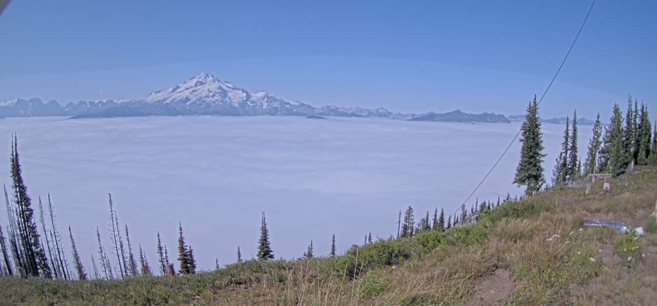
Miners Complex Daily Update 08 14 2024
Related Incident: Miners Complex Fires
Publication Type: Announcement
11:00 AM, August 14, 2024
Estimated size: 1,098 acres
Start Date/Time: July 17, 2024
Area of Origin: 21 air miles east of Darrington WA
Cause: Lightning
Fuels/Topography: timber, rugged terrain
Structures Damaged: None, there are no homes threatened at this time.
Evacuations: None
The Miners Complex consists of ten wildfires caused by lightning strikes in the Mt. Baker-Snoqualmie National Forest. The fires included in the complex are: Miners Fire, Vista Ridge Fire, Dolly Creek Fire, Sulphur Three Fire, Sulphur Four Fire, Sulphur Thirty-Four Fire, Upper Sulphur Thirty-Two Fire, Lower Sulphur Thirty-Two Fire, Plummer, and Middle Ridge Fire.
Update: Minimal activity occurred again yesterday due to the cooler weather and heavy cloud fronts. This stretch of cool weather has allowed for better recovery with higher relative humidities, meaning that fuels have been carrying more moisture, keeping fire activity minimal. Firefighters patrolled and monitored the area yesterday, and patrols will continue today.
Weather: Dry and slightly warmer conditions today although humidities remain high with excellent overnight recoveries. There's a chance of afternoon showers on Thursday with thunderstorm chances closer to the Cascade crest. Sunny, max temperatures around 72. Light winds becoming west 5 to 6 mph in the afternoon.
Smoke: For more information on smoke and air quality please visit: https://wasmoke.blogspot.com/
Closures: The following is a summary of the areas closed due to the fires in the Miners Complex. Pacific Crest National Scenic Trail #2000.2 from Mica Lake to Suiattle Pass, Suiattle River Trail #784, Miners Ridge Trail #785, Buck Creek Pass Trail #789, Miners Cabin Trail #795, Grassy Point Trail #788, Sulphur Mountain Trail #794, Sulphur Creek Trail #793, Sulphur Creek Campground, Sulphur Creek Trailhead, and the Downey Creek trailhead. The full Closure Orders visit: https://www.fs.usda.gov/mbs
Forest Restrictions: The Mt. Baker-Snoqualmie has a full campfire ban and forest-wide shooting restrictions in place to help prevent human-caused starts during this period of unprecedented resource scarcity. Additional details at: www.fs.usda.gov/mbs
###