
Dixon Fire Morning Update 8152024 08 15 2024
Related Incident: Dixon Fire
Publication Type: News
Containment Increases and Highway Reopens on Dixon Fire
DAYS CREEK, Ore. – Containment has increased to 4% on the Dixon Fire, thanks to the collaborative eIorts of resources. Overnight, crews secured tactical firing areas on the southern edge and installed hose lays along dozer line to assist with mop up near FSRD 1610, the 100-spur and 200 road. Acreage was also updated this morning due to GPS and detailed mapping.
Hazard tree removal along the Tiller Trail Highway has been completed. The closure on the highway between South Umpqua Rd and Devils Knob Rd has been lifted and the road is reopened. Drivers should proceed with caution through the fire area, as debris rollout is possible, and fire traffic will be entering and exiting the highway.
Today, crews will extend mop up around structures up to 100 feet out from buildings. Hazard tree removal will continue within the fire footprint to address snags. The tactical removal of unburned fuels will continue within the fire perimeter to strategically remove ground fuels that could generate significant or unpredictable growth if left untreated.
As the structure threat diminishes, Oregon State Fire Marshal (OSFM) is drawing down resources. Task forces from Benton County and Multnomah County will be demobilized today, with the remainder of OSFM returning to their home agencies tomorrow. Structure protection will be provided as needed by remaining fire crews and local resources.
The community meeting last night was well attended. We would like to extend our thanks to the South Umpqua Community Church, and appreciation to the community for their engagement and support. Evacuations: Douglas County Sheriff and Dixon Fire operations are meeting today to discuss downgrading some evacuation zones. Evacuation levels will be updated by the Douglas County Sheriff. Please stay up to date here: https://www.dcso.com/270/Evacuations
The official Red Cross call-in shelter is now at:
Days Creek Charter School
11381 Tiller Trail Hwy, Days Creek, OR 97429
Please call (541) 580-1867 or (541) 801-4971 if you need access.
Forest Closures: There is a forest closure in place.
Order: https://www.fs.usda.gov/Internet/FSE_DOCUMENTS/fseprd1200029.pdf
Map: https://www.fs.usda.gov/Internet/FSE_DOCUMENTS/fseprd1200030.pdf
Fire Information Board Locations:
https://www.google.com/maps/d/edit?mid=13vb6f48bmfpMszOGMdkoVLIIgXQd4s0&usp=sharing
Smoke Outlook: A smoke condition warning has been issued for the immediate area.
For updates check: https://fire.airnow.gov/
Infrastructure Update: Pacific Power crews are in the community doing fire hardening measures, inspections and repair work. They will continue to provide updates to impacted customers via phone/email/text.
For information on current outages, visit:
https://www.pacificpower.net/outages-safety.html
En español: https://www.pacificpower.net/es/apagones.html
For information on wildfire mitigation and safety eIorts, visit:
https://www.pacificpower.net/outages-safety/wildfire-safety.html
For questions, please reach out to the Pacific Power Customer Service team at 1-888-221-7070
Middle Fork Complex Wapiti Bulltrout Daily Update 08 15 2024
Related Incident:
Publication Type: News
Incident Commander: Rick Connell, Northern Rockies Team 5
Middle Fork Complex Location: 9 miles east of Garden Valley, ID
Bulltrout Location: 15 miles WNW OF Stanley, ID Wapiti Location: 2 miles southwest of Grandjean, ID
Start Dates: 07/24/24 – 08/06/2024
Cause: Lightning
Size: Bulltrout: 271 acres Wapiti: 3,646 acres
Middle Fork Complex: Bulldog: 2,713 acres Nellie: 5,595 acres
Containment: Middle Fork Complex: 0% Wapiti: 0% Bulltrout: 92%
Resources on site:
Middle Fork Complex: 3 hotshot crews; 6 type 2 hand crews; 11 engines; 2 bulldozers; 4 water tenders; 1 skidgen
Wapiti: 1 type 2 hand crew; 8 engines; 1 water tender
Bulltrout: 1 engine
Total Personnel: Middle Fork Complex: 413 Wapiti: 61 Bulltrout: 20
KEY MESSAGE:
On August 12, 2024, the Boise National Forest adjusted the fire closure areas. All roads and trails remain closed within these closures, to provide for public and firefighter safety. Please reference specific closures on the Forest’s website and the fire’s InciWeb page.
CURRENT STATUS/PLANNED ACTIONS:
Middle Fork Complex: The Middle Fork Complex is comprised of the Bulldog and Nellie fires.
On the Bulldog Fire, firefighters continue holding and building containment along the southern edge of the fire. Crews are also making progress along the west side of the fire building handline and removing vegetation alongside FS road 698 and to the junction of FS road 698 and FS road 671. Yesterday, helicopters supported the efforts of the crews on the ground by dropping buckets of water to cool the edge of the fire on the southeast side along the Lightning Creek trail. The fire continues to burn to the north and east towards the Rattlesnake (2006) burn area. The public is reminded that the Middlefork Road is closed at the Forest Service boundary just north of Lightning Creek for firefighter and public safety as crews continue to work to protect private property and structures in the vicinity of Crouch.
The Nellie fire is burning in steep terrain with limited access. The fire is burning into the Pioneer Fire (2016) burn area to the east. Firefighters will be doing point protection and will complete wrapping the Deadwood Lookout with fire resistant material to protect the structure from radiant heat and burning embers. The public is reminded that Forest Service Road #555 is closed at the intersection of Highway 17 all the way to the Forest Service Road #579 intersection.
Wapiti Fire: The Wapiti fire continues to slowly burn down the north and northeast side. The fire has reached the South Fork of the Payette River to the northeast providing firefighters with a safe location to implement suppression tactics. The west side of the fire is holding on top of the ridge in rocky barren terrain. Today, the firefighters will continue to ensure their fire edge is secure and patrol the fire line. They will also resume structure protection and any improvements to their water pumping systems for the homes in the area.
Bulltrout Fire: There has been very little change to the Bulltrout fire and containment remains at 92%. Today, firefighters will use an unmanned aerial system (UAS) to search for remaining heat within the fire perimeter and continue to patrol the fireline.
WEATHER AND FIRE BEHAVIOR:
A passing storm system will come through our region today bringing scattered showers and isolated thunderstorms. There will be a break in storm activity midday and the inversion will lift creating convection which may increase fire activity. In the evening, we are expected to see outflow winds with gust up to 40mph. Cloud cover and cool wet conditions aid firefighters in suppression tactics.
CLOSURES, RESTRICTIONS, AND EVACUATIONS:
Middle Fork Complex: The Boise County Sheriff's Office continues to maintain the Level 2 evacuation notice for residents on and near the Middlefork Road between Stump Ranch Road up to Tie Creek Campground. The Boise National Forest issued an area closure for the fire (Closure #0402-06-59) effective August 12, 2024. The purpose of this order is to protect public safety during the fires.
Wapiti Fire: The evacuation order for Summer Homes and the Sawtooth Lodge remain in effect for the Wapiti Fire, as does the area closure issued by the Sawtooth and Boise National Forests (Closure #0402-05-94) effective August 12, 2024. This Order is for public and firefighter safety during fire suppression efforts of the Wapiti Fire.
Bulltrout Fire: The Bull Trout Fire Area Closure (Closure #0402-05-93) remains in effect for the roads and trails within the perimeter of the fire. Boise National Forest issued this order on August,12, 2024. It will be rescinded as soon as it is safe to do so.
Closure information and maps are posted on the Forests’ website and the fire’s Inciweb page as they are in place. https://tinyurl.com/2u8v3pf7
The Boise National Forest, Idaho Department of Lands, and Bureau of Land Management are in Stage 1 fire restrictions on state, endowment, private and federal lands within the West Central Mountains Fire Restrictions Zone. For more information on the restrictions and a map visit:
https://www.idl.idaho.gov/fire-management/fire-restrictions-finder/
Lodgepole Fire Daily Update August 15 2024 08 15 2024
Related Incident: Lodgepole
Publication Type: News
Lodgepole Fire Daily Update - August 15, 2024
Phone: 559-481-7849, 8 a.m. to 8 p.m.
Email: 2024.Lodgepole@firenet.gov
Fire Information: linktr.ee/CIIMT14
Acres: 35
Containment: 0%
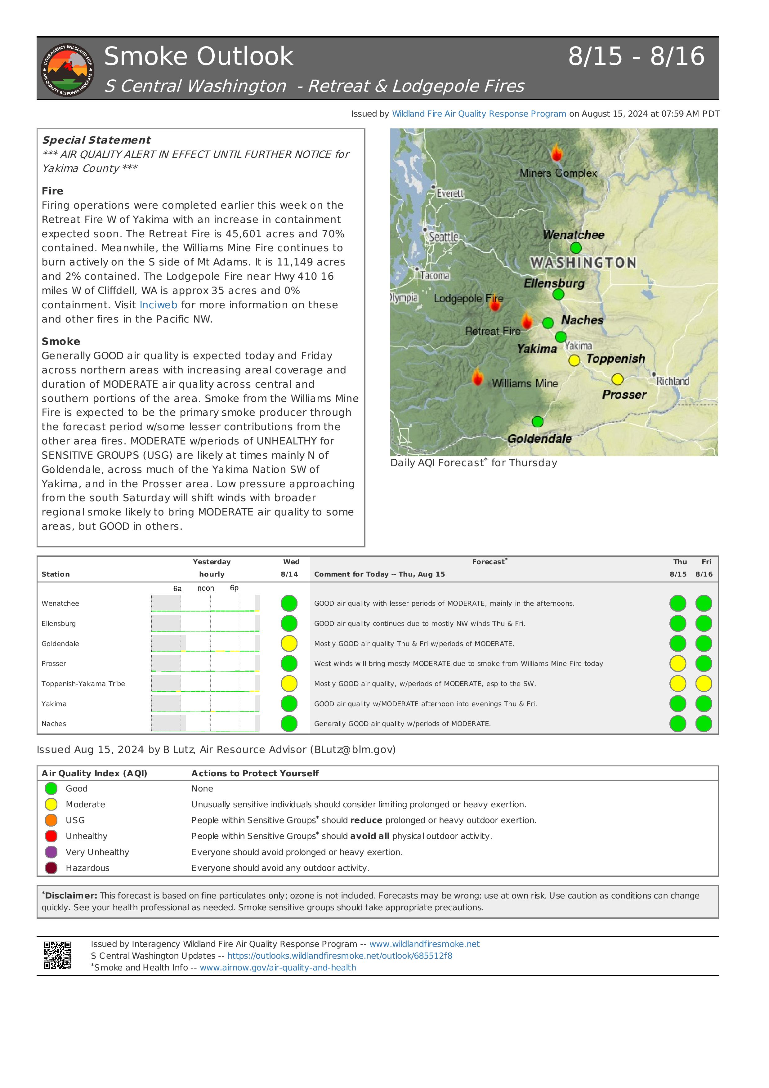
Current Situation: The Lodgepole Fire is currently 35 acres and burning in the Norse Peak Wilderness, north of Highway 410 near the Lodgepole Campground, located within the Okanogan-Wenatchee National Forest. The fire is burning within the burn scar of the 2017 Norse Fire which is filled with large amounts of dead and down debris as well as standing dead trees which are extremely hazardous firefighters.
The fire remains active, consuming and spreading through the down slash and ground fuels, while producing large amounts of heat. Firefighters are working to secure the southern edge of the fire. Dozers and equipment are being used to between the wilderness boundary and the highway to protect and the impact to the transportation corridor.
Making access to the fire’s edge is made difficult due to the large number of standing dead trees. Crews are having to mitigate these hazards as they make their way into the fire area then move this material out of the way. Helicopters will continue to assist ground crews with water dropping missions. These aircraft are working to limit fire spread while firefighters work to make access to the fire’s edge.
The fire remains a threat to multiple privately owned cabins in nearby Forest Service recreational residence cabin tracts. Crews are also continuing their work to assess and clear areas around threatened structures.
Weather: Increasing clouds over the fire area today with a 20% chance of thunderstorms this afternoon. Wind may gust up to 30 mph around thunderstorms. Slight decrease in minimum humidity (30-39%) and slight increase in high temperatures (70’s) over the fire area compared to yesterday.
Closures: The Lodgepole Campground is currently Closed, but there are no other forest or campground closures due to the Lodgepole Fire.
Highway 410 remains open for travel. Please use caution in the area due to smoke impacts as well as firefighters and emergency equipment working along the highway.
Air Quality and Smoke: Air quality and smoke condition outlooks can be found at airnow.gov.
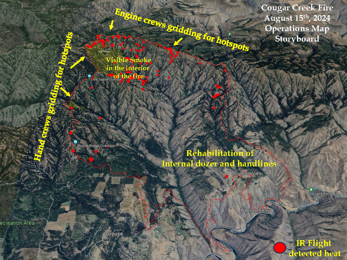
Cougar Creek Fire Daily Update 08 15 2024
Related Incident: Cougar Creek Fire
Publication Type: News
Quick Facts
Size: 24,091 acres Start Date: July 15, 2024 Cause: Under investigation
Location: SW of Clarkston, 1 mile west of Hwy 129 and Grand Ronde River intersection
Containment: 60% Personnel: 262 Fire Strategy: Full suppression
Resources Assigned: 3 crews, 1 helicopter, 25 engines, 10 water tenders, 3 heavy equipment
The Cougar Creek Fire is burning within a mountainous and remote area on the Umatilla National Forest bordering the Wenaha-Tucannon Wilderness.
Operations: At 7 pm on Tuesday evening, command of the Cougar Creek fire was transitioned over to Northeast Washington Type 3 Team 1 from Interagency Incident Management Team Northwest 12. NW12 completed a full operational period with the new team to ensure all communication and logistical needs were met for operational success and demobilized.
Yesterday, crews working the fire line in Division G to the north along the 43 road worked to reinforce the control line by identifying hazards and mitigating hotspots. This area is in mixed topography with steep incised canyons creating challenging obstacles for fire crews. However, the control lines remain secure with minimal growth.
On the western flank in Division D, hand crews working 40 road continued fire line hazard mitigation within the fire perimeter, as engines and tankers are unable to access the area due to terrain.
Divisions A (southern line) and Division P (eastern line) unified as heavy equipment crews’ continued suppression repair work on the non- primary fire line.
Reconnaissance flights were performed, and no additional areas of concern were identified. Data collected from the flight coincided with the information being reported by ground crews.
Today, firefighters will continue mop-up operations along the west and northwest portions of the fire. On the south and east sides of the fire, crews will continue to backhaul remaining equipment and supplies. Fire managers will also continue to assess fire suppression repair work to help mitigate long-term impacts to natural resources from fire suppression activities.
Evacuations and Closures: All evacuation orders have been lifted. Forest closure descriptions and maps are available online on the Umatilla National Forest closure website. Please respect area closure orders and use extra caution while driving for your safety as well as our firefighters.
Weather and Smoke: High 75/Low 64: Sunny this morning turning partly clouding this afternoon. Increasing chance of showers and thunderstorms in the afternoon into the evening hours. Smoke from the Cougar creek fire will be visible on the west northern and western flanks. Air quality in the region is moderate. Learn more about smoke at http://wasmoke.blogspot.com/.
InciWeb: https://inciweb.wildfire.gov/incident-information/wases-cougar-creek-fire
Facebook: https://www.facebook.com/CougarCreekFire2024
Fire Information Line: 509-210-2928, 8 AM to 6 PM
Email: 2024.cougarcreek@firenet.gov
Retreat Fire Morning Update August 15 2024 08 15 2024
Related Incident: Retreat
Publication Type: News
Retreat Fire Morning Update - August 15, 2024
Phone: 509-213-4890, 8 a.m. to 8 p.m.
Email: 2024.Retreat@firenet.gov
Fire Information: linktr.ee/CIIMT14
Total Acres: 45,601 acres Containment: 70% Total Personnel: 367
Current Situation: As firefighters patrol control lines around the perimeter of the Retreat Fire, they continue to find and extinguish a few areas of smoldering fuels. The shaded fuel break along Forest Roads 1200 and 1201 to protect structures in the Rimrock Lake area, is complete and fuels (logs and brush) removed from along these roads are being moved off site. Crews are falling hazard trees along internal road systems within the fire perimeter to provide for safer access across the fire and patrol the fire perimeter. Crews are removing unneeded equipment and fire hose from the fireline and beginning fire suppression repair (road grading, hazard tree felling, and dozer line repair) where they are confident the fire is fully contained.
Along State Highway 12, Washington Department of Transportation crews continue working to replace guard rails and signs damaged by the fire, as this highway remains a top priority so it can be opened and evacuation orders lifted as soon as possible.
The control objective for the Retreat Fire is to keep the fire contained within the natural and constructed control features while prioritizing public and firefighter safety.
Weather: Increasing clouds over the fire area today with a 20% chance of thunderstorms this afternoon. Wind may gust up to 30 mph around thunderstorms. Slight decrease in minimum humidity (30-39%) and slight increase in high temperatures (70’s) over the fire area compared to yesterday.
Evacuations: For the most up-to-date information on evacuations, please visit the Yakima County Emergency Management website at yakimacounty.us/350.
Fire Closures:
- US Highway 12 remains closed between the Y at Highway 410 and the summit of the pass at milepost 151.
- Okanogan-Wenatchee National Forest Retreat Fire Closure (tinyurl.com/5ext5aec).
- The Washington State Department of Natural Resources (DNR) Southeast Region has temporarily closed part of the Ahtanum State Forest. The public can access the most up-to-date closure information at dnr.wa.gov/ahtanum.
- Washington Department of Fish and Wildlife has closed the majority of the Oak Creek Wildlife Area to public access due to the Retreat Fire until August 23, 2024. More information can be found at tinyurl.com/bdet7845.
Air Quality and Smoke: Air quality and smoke condition outlooks can be found at airnow.gov.

Homestead Complex Fire Update08 15 2024
Related Incident:
Publication Type: News
The Homestead Complex includes seven fires totaling 4,979 acres with an overall containment of 25%. There are 600 personnel currently working on the fire. Fire managers continue directing resources to fires based on threats to property, infrastructure, industry, and areas with the highest probability of success while providing for firefighter and public safety. The fire is being managed by Northwest Incident Management Team 8.
Yesterday, on the No Man Fire (1,779 acres), crews continued with tactical burning operations along the south flank of the fire. To the north, firefighters focused on holding, maintaining and strengthening control lines. Crews also continued to improve contingency lines along roads progressing south toward control lines on the Salmon 33 Fire. Two engines patrolled the area overnight. The Salmon 33 (246 ac.) Fire remained within its footprint as fire personnel strengthened control lines with mop-up operations. Work continued on improving additional control lines that will tie into lines coming from the No Man Fire. On the Horse Heaven Creek Fire (1,770 ac.), crews continued to make progress with tactical burnouts down the eastern flank of the fire heading to the southeast corner. At the northwest corner of the fire, the fire has crossed over control lines near the bottom of Horse Heaven Creek. Lakeview Hotshots were scouting for locations to establish control lines around this “slopover” to tie it back into existing control lines. Work continues on improving contingency control lines along the 5850 road with heavy equipment. Holding and mop-up operations continued along the southern flank. On the Bullpup Fire (443 ac.), crews moderated fire behavior with a series of check lines as it approached control lines. Additional dozer line was put in to tie in with other control line along the northeast corner of the fire. Engines patrolled the 300 Road, keeping fire within the control lines. On the Fuller Lake Fire (372 ac.), along the eastern flank of the fire, crews were engaged in holding the fire within control lines as it backed down and burned along the 5851 Road serving as a control line. Firefighters looked for containment opportunities on the northern flank of the fire. Old burn scars from a past forest fire has slowed the fire along its southern flank. The Reynolds Butte Fire (335 ac) continued to show little activity and crews continued mopping up in that area.
Today, on the No Man and Salmon fires, crews will be looking for opportunities on the north flank of No Man Fire to continue tactical burnouts. Work will also continue on prepping contingency lines on the 3811 and 3815 roads, progressing east then south, with the objective of connecting into control lines along the Salmon 33 Fire. Holding and mop-up efforts continue on both fires. On the Horse Heaven Creek Fire, a new division (Division K) has been added to manage the western half of the fire, where there has been increased burning activity in the northwest corner. Fire managers will be assessing this area for establishing additional indirect and contingency control lines should they be needed. At the northwest corner of the fire, where the fire has slopped-over control lines near the bottom of Horse Heaven Creek, firefighters will be scouting for opportunities to establish control lines around the slopover. Should weather conditions allow for it, crews plan to continue with tactical burnouts progressing south along the eastern side of the fire. Work will continue on improving contingency control lines along the 5850 road with heavy equipment. Holding and mop-up operations continue along the southern flank. Firefighters assigned to the Bullpup and Fuller fires will continue working to keep the fires within the control lines along roads and dozer lines. Work will continue on improving control lines along the 300 and 380 roads. Crews will continue patrolling and holding along the 5851 Road as the fire moves downslope and along the road. On the Reynolds Butte Fire, mop-up operations have made great progress to the point where the fire will likely be put in a patrol status in the near future requiring minimal staffing. This will allow other resources working the fire to be reallocated to more active fires on the complex. The Lost Bucket Fire (34 ac.) was contained on July 29 and remains in a patrol status.
Today’s weather: The forecast calls for cooler temperatures and higher humidity. Temperatures for the higher elevations will be in the mid-60s, and mid-70s in lower areas. Ridgetop winds in the morning will be from the east-northeast, becoming northwest by mid-afternoon.
Current forest fire restrictions and danger ratings are -
Fire Danger Rating: Very High
Industrial Fire Precaution Levels (IFPL): 3
Public Use Fire Restrictions (PUR): 3
CLOSURES: The Bureau of Land Management (BLM), Roseburg District, has issued a closure order for portions of BLM land which border the Umpqua National Forest Emergency Fire Closure north of Steamboat. The closure order can be viewed here: https://www.blm.gov/sites/default/files/docs/2024-07/orwa-fpo-rbg-072624.pdf.
The Umpqua National Forest has Emergency Fire Closures in place impacting every district of the forest. https://www.fs.usda.gov/alerts/umpqua/alerts-notices.
Fire Prevention: Even with cooler weather, the vegetation is still dry and very susceptible to an unwanted fire start. Please continue to use extreme caution when recreating and working outdoors. 9 out of 10 wildfires nationally are started by a human, mostly all accidental. It only takes one spark!
Middle Fork Complex Wapiti Bulltrout Daily Update 08 15 2024
Related Incident: Bulltrout Fire
Publication Type: News
Incident Commander: Rick Connell, Northern Rockies Team 5
Middle Fork Complex Location: 9 miles east of Garden Valley, ID
Bulltrout Location: 15 miles WNW OF Stanley, ID Wapiti Location: 2 miles southwest of Grandjean, ID
Start Dates: 07/24/24 – 08/06/2024
Cause: Lightning
Size:
Bulltrout: 271 acres Wapiti: 3,646 acres
Middle Fork Complex: Bulldog: 2,713 acres Nellie: 5,595 acres
Containment: Middle Fork Complex: 0% Wapiti: 0% Bulltrout: 92%
Resources on site:
Middle Fork Complex: 3 hotshot crews; 6 type 2 hand crews; 11 engines; 2 bulldozers; 4 water tenders;
1 skidgen
Wapiti: 1 type 2 hand crew; 8 engines; 1 water tender
Bulltrout: 1 engine
Total Personnel: Middle Fork Complex: 413 Wapiti: 61 Bulltrout: 20
KEY MESSAGE:
On August 12, 2024, the Boise National Forest adjusted the fire closure areas. All roads and trails remain closed within these closures, to provide for public and firefighter safety. Please reference specific closures on the Forest’s website and the fire’s InciWeb page.
CURRENT STATUS/PLANNED ACTIONS:
Middle Fork Complex: The Middle Fork Complex is comprised of the Bulldog and Nellie fires.
On the Bulldog Fire, firefighters continue holding and building containment along the southern edge of the fire. Crews are also making progress along the west side of the fire building handline and removing vegetation alongside FS road 698 and to the junction of FS road 698 and FS road 671. Yesterday, helicopters supported the efforts of the crews on the ground by dropping buckets of water to cool the edge of the fire on the southeast side along the Lightning Creek trail. The fire continues to burn to the north and east towards the Rattlesnake (2006) burn area. The public is reminded that the Middlefork Road is closed at the Forest Service boundary just north of Lightning Creek for firefighter and public safety as crews continue to work to protect private property and structures in the vicinity of Crouch.
The Nellie fire is burning in steep terrain with limited access. The fire is burning into the Pioneer Fire (2016) burn area to the east. Firefighters will be doing point protection and will complete wrapping the Deadwood Lookout with fire resistant material to protect the structure from radiant heat and burning embers. The public is reminded that Forest Service Road #555 is closed at the intersection of Highway 17 all the way to the Forest Service Road #579 intersection.
Wapiti Fire: The Wapiti fire continues to slowly burn down the north and northeast side. The fire has reached the South Fork of the Payette River to the northeast providing firefighters with a safe location to implement suppression tactics. The west side of the fire is holding on top of the ridge in rocky barren terrain. Today, the firefighters will continue to ensure their fire edge is secure and patrol the fire line. They will also resume structure protection and any improvements to their water pumping systems for the homes in the area.
Bulltrout Fire: There has been very little change to the Bulltrout fire and containment remains at 92%. Today, firefighters will use an unmanned aerial system (UAS) to search for remaining heat within the fire perimeter and continue to patrol the fireline.
WEATHER AND FIRE BEHAVIOR:
A passing storm system will come through our region today bringing scattered showers and isolated thunderstorms. There will be a break in storm activity midday and the inversion will lift creating convection which may increase fire activity. In the evening, we are expected to see outflow winds with gust up to 40mph. Cloud cover and cool wet conditions aid firefighters in suppression tactics.
CLOSURES, RESTRICTIONS, AND EVACUATIONS:
Middle Fork Complex: The Boise County Sheriff's Office continues to maintain the Level 2 evacuation notice for residents on and near the Middlefork Road between Stump Ranch Road up to Tie Creek Campground. The Boise National Forest issued an area closure for the fire (Closure #0402-06-59) effective August 12, 2024. The purpose of this order is to protect public safety during the fires.
Wapiti Fire: The evacuation order for Summer Homes and the Sawtooth Lodge remain in effect for the Wapiti Fire, as does the area closure issued by the Sawtooth and Boise National Forests (Closure #0402-05-94) effective August 12, 2024. This Order is for public and firefighter safety during fire suppression efforts of the Wapiti Fire.
Bulltrout Fire: The Bull Trout Fire Area Closure (Closure #0402-05-93) remains in effect for the roads and trails within the perimeter of the fire. Boise National Forest issued this order on August,12, 2024. It will be rescinded as soon as it is safe to do so.
Closure information and maps are posted on the Forests’ website and the fire’s Inciweb page as they are in place. https://tinyurl.com/2u8v3pf7
The Boise National Forest, Idaho Department of Lands, and Bureau of Land Management are in Stage 1 fire restrictions on state, endowment, private and federal lands within the West Central Mountains Fire Restrictions Zone. For more information on the restrictions and a map visit:
https://www.idl.idaho.gov/fire-management/fire-restrictions-finder/
Willamette Complex North Daily Update 08 15 2024
Related Incident: North Willamette Complex
Publication Type: News
SPECIAL NOTE
There will be a community meeting for the Willamette Complex North Saturday, August 17th at 11 a.m. The meeting will take place at the McKenzie High School (new gym) located at 51187 Blue River Dr, Finn Rock, OR 97488.
CURRENT SITUATION
Cooler temperatures, increased humidity, and greater smoke/cloud coverage is expected to contribute to a decrease in fire behavior today. The Ore and Pyramid fires continue to be managed for full suppression.
Ore Fire
Blue River, 2,864 Acres, 12% Contained, 147 Total Personnel, Cause Under Investigation
Yesterday, crews continued to evaluate opportunities to conduct burnout operations along the northern flank of the fire—with the goal of inhibiting fire growth beyond the 1509 and 827 Roads. Night crews observed minimal activity on the southern end of the fire and established a perimeter around a spot fire to the north, where more active fire behavior was observed. Today, crews will continue to secure the spot fire, before evaluating opportunities to continue firing operations. Crews and heavy equipment across the Ore Fire will continue to prepare indirect lines, patrol the fire perimeter, suppress flare-ups or hot spots, and secure threats to the line by removing trees, snags, and other fuels.
Pyramid Fire
East of Middle Santiam Wilderness, 1,323 Acres, 73% Contained, 223 Total Personnel, Lightning Caused
Crews and heavy equipment continue to hold and improve fire lines, patrol the fire perimeter, and conduct mop up. Pockets of intense and scattered heat continue to be identified by infrared technology.
Weather & Fire Behavior
A strong pulse of moisture this morning will greatly influence the forecast. Predicted maximum temperature is 70 to 74 °F in the valleys and 66 to 70 °F on the ridgetops. Predicted minimum relative humidity is 54 to 60% in the valleys and 64 to 70% on the ridgetops. Weather conditions are expected to result in a decrease in fire behavior today, however, heavy dead and down fuels continue to hold heat. For smoke and air quality conditions visit: AirNow.gov
Evacuations, Closures & Fire Restrictions
On July 17th, the Linn County Sheriff’s Office, in coordination with the Willamette National Forest, issued a Level 3: Go Now Evacuation Alert for the closure area affected. Please refer to the Linn County Fire Map tinyurl.com/LinnCoFireMap for full details of the issued evacuation area (which will appear in red). To sign up for evacuation alerts, visit linnsheriff.org/.
Area, road, trail, and recreation site closures are in effect in the Willamette National Forest.
Specific information is posted at https://www.fs.usda.gov/alerts/willamette/alerts-notices/?aid=61574.
Fire restrictions are in effect for Willamette National Forest. Read the complete restrictions at: https://www.fs.usda.gov/alerts/willamette/alerts-notices/?aid=81487.
Wildfires are a no-fly zone for unauthorized aircraft, including drones. If you fly, we can’t.
For more information, visit http://knowbeforeyoufly.org.