
Park Fire Afternoon Update for August 15 08 15 2024
Related Incident: Park Fire
Publication Type: News
The Park Fire Afternoon Update for August 15 is posted on the Park Fire Status Update Page
Dixon Fire Evening Update 8152024 08 16 2024
Related Incident: Dixon Fire
Publication Type: News
Structure Protection Efforts Winding Down
DAYS CREEK, Ore. – Following another day of successful efforts on the Dixon Fire, the Oregon State Fire Marshal (OSFM) will demobilize tomorrow morning. OSFM personnel and task forces have been instrumental in protecting structures and local communities.
“We are achieving 100 feet of cold black with little potential for reignition around all structures” said Jon Koenig, Operations Section Chief trainee with OSFM. The Oregon Department of Forestry (ODF) incident management team will continue in command of the fire. ODF and local resources will provide further structure protection as needed.
Today, crews focused on extensive mop up at control lines and around structures. Mopping up is the process of removing or extinguishing burning material and heat. This reduces the likelihood of fire escaping and is a key step to increasing containment. Crews also continued to remove unburned fuels between the fire’s edges and established lines. Snags, or dead trees, are an ongoing hazard that sawyers are felling across the fire area.
Localized light smoke may be visible as pockets of fuels are consumed during operations. The smoke outlook predicts good air quality through tomorrow for Roseburg, Canyonville, and Glide.
There are several important changes to local conditions:
• Evacuations: Evacuation levels are managed by the Douglas County Sheriff and were updated this afternoon. All Level 3 evacuations have been removed. Level 2 and 1 evacuations remain in place but boundaries have changed. When returning to a Level 2 area, residents should be prepared to leave at a moment’s notice, and be aware of hazards from fire traffic, burned and green trees, and burned ground. Please stay up to date on evacuation levels at: http://www.dcso.com/evacuations
• Shelter: The official Red Cross call-in shelter has closed.
• Road closures: The Tiller Trail Highway is reopened. The public is encouraged to exercise caution in the area as fire traffic remains active and falling rocks are possible.
Forest closures: There are two forest closures impacting every district of the Umpqua National Forest. The Rocky Ridge Fire closure has been rescinded. Closure information can be found here: https://www.fs.usda.gov/alerts/umpqua/alerts-notices
.
Fire Information Board Locations: https://www.google.com/maps/d/edit?mid=13vb6f48bmfpMszOGMdkoVLIIgXQd4s0&usp=sharing
Smoke Outlook: https://fire.airnow.gov/#
Infrastructure Update: Pacific Power crews are in the community doing fire hardening measures, inspections, and repair work. They will continue to provide updates to impacted customers via phone/email/text.
For information on current outages, visit:
https://www.pacificpower.net/outages-safety.html
En español: https://www.pacificpower.net/es/apagones.html
For information on wildfire mitigation and safety efforts, visit:
https://www.pacificpower.net/outages-safety/wildfire-safety.html
For questions, please reach out to the Pacific Power Customer Service team at 1-888-221-7070.
Falls and Telephone Fires Update for Aug 16 2024 08 16 2024
Related Incident: Falls FireTelephone Fire
Publication Type: News
Falls and Telephone Fires Update for August 16, 2024
Telephone Fire Quick Facts:
Containment: 95%
Size: 54,034 acres
Start Date: July 22, 2024
Location: 12 miles NE of Burns, OR
Cause: Lightning/Natural
Falls Fire Quick Facts:
Containment: 89%
Size: 151,680 acres
Start Date: July 10, 2024
Location: 13 miles NW of Burns, OR
Cause: Human-caused
Telephone and Falls Fires: Yesterday, crews monitored and patrolled the Telephone Fire, focusing on backhauling equipment and supplies back to camp where it will be prepared to support other fires. Mastication continued on the 2830 Road near the Little Black Rock area. On the Falls Fire, in addition to monitor and patrol, crews used road graders to repair sections of the 43 and 41 Roads in the Parker Creek and Spring Canyon areas. Today, crews will remain focused on remaining prepared for initial attack and increasing mop up depth on the northeast portion of the Falls Fire and the northwest portion of the Telephone Fire. Backhaul will continue on both fires.
Weather: Yesterday afternoon’s thunderstorms dropped additional wetting rains on the fires, especially parts of the Falls Fire, which received up to 3⁄4 of an inch. Today’s temperatures are expected to be in the 70s with moderate winds out of the southwest. Looking ahead, conditions on Saturday will begin a warming and drying trend and sustained south winds will be strong, favoring fire activity.
Evacuations: For up-to-date information, visit the Harney County Sheriff’s evacuation map: https://bit.ly/FallsFireEvac, or the Grant County Emergency Management Facebook page: https://www.facebook.com/profile.php?id=100068819321423
Closures: A closure is in effect for the southern area of the Malheur National Forest. A closure map is available on the Malheur National Forest website (https://www.fs.usda.gov/detail/malheur/news- events/?cid=FSEPRD1198892).
Temporary Flight Restriction (TFR): TFRs in the area have been changing; pilots should check the latest information on the Federal Aviation Administration TFR website prior to flying: https://tfr.faa.gov/tfr_map_ims/html/index.html
Facebook: https://www.facebook.com/p/Falls-Fire-2024-61562126623985/
Falls Fire InciWeb: https://inciweb.wildfire.gov/incident-information/ormaf-falls-fire
Telephone Fire InciWeb: https://inciweb.wildfire.gov/incident-information/ormaf-telephone-fire
Fire Information Line: 541-208-4370, staffed 8 a.m. to 8 p.m.
Email: 2024.Falls@firenet.gov
Harney County Non-emergency Evacuation Questions: 541-589-5579
Air quality: https://fire.airnow.gov/
Smoke Outlooks: https://outlooks.airfire.org/outlook
Park Fire Afternoon Update for August 14 08 14 2024
Related Incident: Park Fire
Publication Type: News
The Park Fire Afternoon Update for August 14 is posted on the Park Fire Status Update Page
Coffeepot Fire News Release08 16 2024
Related Incident: Coffee Pot Fire
Publication Type: News
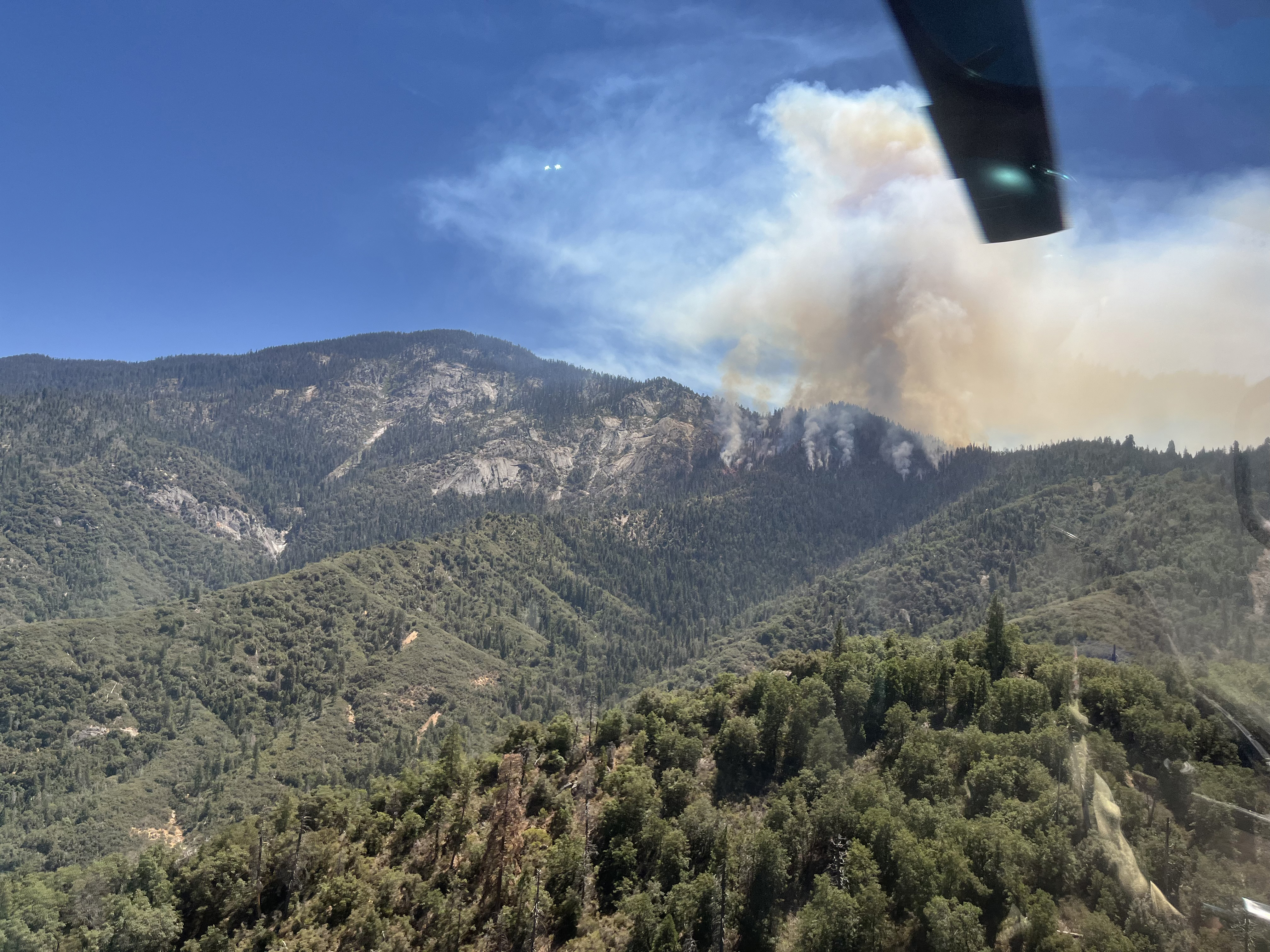
On August 3 a lightning-caused fire was located in the southwest corner of Sequoia National Park that was sized at 0.1 acre. It was quickly contained by fire crews, but after nearly a week of no activity, a burning tree fell and rolled over the containment line, and the fire began to grow, reaching five acres by Monday, August 12.
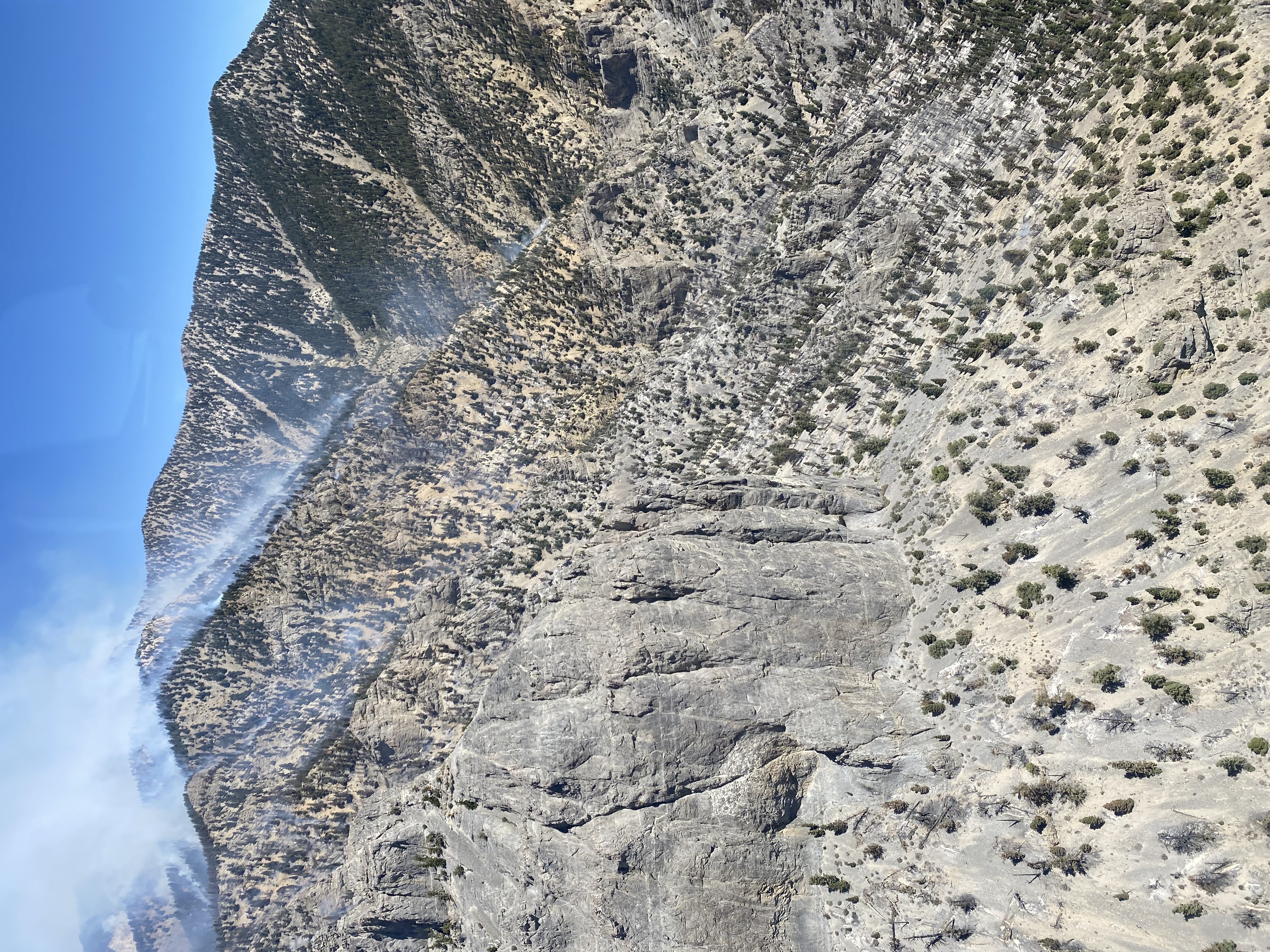
Since then, the fire has continued to grow, as expected, slowly down steep terrain. The Coffeepot Fire has reached nearly 100 acres due to large burning logs rolling downhill and the dry fuels on the rugged landscape. This fire does not currently pose a threat to life or property, and fire crews are actively working on suppression efforts. It is expected that this fire remains on the landscape for weeks to come.
On August 14, the fire expanded along the southwestern perimeter as it entered into Bureau of Land Management jurisdiction. At this time the fire is being managed by the National Park Service. A Type 3 Incident Command Team will be arriving on Friday, August 16, and will assume management of this fire in the coming days, while continuing to work closely with local NPS fire personnel, Cal Fire, Tulare County Fire, BLM, and others.
Efforts to suppress this wildfire include 70 fire personnel, one fire engine, 18 helicopters, and multiple fixed-wing air tankers.
Retreat Fire Evacuation Update 816202408 15 2024
Related Incident: Retreat
Publication Type: Closures
Retreat Fire Evacuation Update 8-16-2024
PER Yakima Valley Emergency Management:
Evacuation update for the Retreat fire on Highway 12.
All evacuation orders have been removed as of 8:00 a.m. Friday, August 16th, 2024.
Residents will be allowed through the Highway 12 road closure to make access to their property with proper proof of residency.
Reminder that State and Forest lands are still in a closed status until further notice.
Highway 12 is anticipated to open in the coming days. Washington State Department of Transportation has crews working to reopen the road. There will be areas that will have reduced speed and traffic controls where road work is being done. For road opening information please visit the Washington DOT website.
You can find the current evacuation zone map here (scroll down the page)
Broom Canyon Fire Update 08 15 2024
Related Incident: Broom Canyon Fire
Publication Type: News
The 4,273-acre Broom Canyon Fire located nine miles east of Duckwater or 60 miles southwest of Ely, Nevada, continues to burn in steep, rugged, and inaccessible terrain, on Currant Mountain within the Currant Mountain Wilderness. This lightning-caused fire is currently located in an area where firefighter safety mitigations cannot be achieved therefore fire suppression actions are not being taken.
Our wildland firefighters risk their lives every day to protect communities, critical infrastructure, and natural resources,” said Ely District Ranger Jose Noriega. “It is extremely important to know when it is safe and not safe to deploy firefighting resources.”
The Ely Ranger District is managing the Broom Canyon Fire under a confine and contain strategy. A planning boundary has been established for areas which provide safe opportunities for suppression actions. Firefighters are also improving roads that have been identified as contingency fire lines should the fire move outside the planning boundary to the west.
The Broom Fire, which was first reported at approximately 8 p.m. on Monday, July 29, continues to smolder and produce isolated torching with moderate fire activity. Over the past several days, the fire has made runs to the north and south depending upon the wind direction. The fire is burning in white fir, pinyon pine and juniper, but also leaving lots of unburned vegetation resulting in a mosaic pattern.
Smoke is very visible during the day to residents of Currant, Duckwater and surrounding areas as well as motorists on U.S. Highway 6. On days where there is increase fire activities the smoke is visible in Ely. Smoke and fire activity will likely be seen into September and October until the first snow hits the mountain. For updates on air quality, visit: www.fire.airnow.gov.
Ely Ranger District (Aug. 15, 2024, at 3:30 p.m.)
- Acres: 4,273
- Location: Burning on Currant Mountain in the Currant Mountain Wilderness, which is nine miles east of Duckwater or 60 miles southwest of Ely, Nevada.
- Start Date: July 29, 2024
- Cause: Lightning
- Containment: 0%
- Personnel: 20
Fire Information:
- Inciweb: https://inciweb.wildfire.gov/incident-information/nvhtf-broom-canyon-fire
- Facebook: https://www.facebook.com/HumboldtToiyabeNF #BroomCanyonFire
- X (formerly Twitter): https://x.com/HumboldtToiyabe #BroomCanyonFire
Forest Orders Boise Fire Closure Areas 08 15 2024
Related Incident: 2024 Boise Fire
Publication Type: Closures
For public safety, the following acts are prohibited within Six Rivers National Forest and Klamath National Forest. Forest Orders NO. 10-24-11 and NO. 24-05-09 are effective from August 16, 2024, through September 15, 2024.
1. Going into or being upon National Forest System lands within the Boise Fire Closure Area, as described in Exhibit A and shown on Exhibit B. 36 C.F.R. § 261.52(e).
2. Being on any National Forest System Road within the Boise Fire Closure Area, as shown on Exhibit B. 36 C.F.R. § 261.54(e).
3. Being on any National Forest System trail within the Boise Fire Closure Area, as shown on Exhibit B. 36 C.F.R. § 261.55(a). 4. Entering or using Le Perron Flat Dispersed Camping Area, Salmon Summit Trail Head, Big Rock River Access, Nordheimer Campground and High Point Trailhead. 36 C.F.R. § 261.58(b).
4. Entering or using Le Perron Flat Dispersed Camping Area, Salmon Summit Trail Head, Big Rock River Access, Nordheimer Campground and High Point Trailhead. 36 C.F.R. § 261.58(b).
A violation of these prohibitions is punishable by a fine of not more than $5,000 for an individual or $10,000 for an organization, or imprisonment for not more than six months, or both. 16 U.S.C. § 551 and 18 U.S.C. §§ 3559, 3571, and 3581.
Forest Service BAER Team Begins PostFire Assessment of Borel Fire 08 15 2024
Related Incident: Borel Post-Fire BAER
Publication Type: News
BOREL POST-FIRE BAER ASSESSMENT UPDATE
August 15, 2024
Forest Service BAER Team Begins Post-Fire Assessment of Borel Fire
A Forest Service Burned Area Emergency Response (BAER) team has been established by the Sequoia National Forest (NF) to begin a post-fire burned area assessment of the Borel Fire that recently burned on National Forest, Bureau of Land Management (BLM), and private lands. The BAER team leaders are Todd Ellsworth and Keith (Andy) Stone. Forest Service BAER team assessments typically take approximately two weeks to complete.
BAER teams coordinate with the Natural Resources Conservation Service (NRCS), National Weather Service (NWS), US Geological Survey (USGS), Bureau of Land Management (BLM), and other federal, state, counties, and other local agencies as they assess potential post-fire impacts to the burned watersheds.
BAER surveys are rapid assessments that evaluate the burned area to identify watersheds having increased potential for post-fire flooding, sediment flows and rockslides, and assist land managers to prepare the burned area for seasonal thunder cell storms. The team focus is on potential emergency impacts to human life and safety on federal land. They also model hydrologic response throughout the burned area and share the team’s findings with the affected downstream agencies.
BAER teams may consist of scientists and specialists including hydrologists, geologists, soil scientists, road engineers, botanists, biologists, archeologists, and geographic information specialists. BAER teams collect field data during their burned area surveys to analyze through GIS and computer models and present their findings along with recommended BAER emergency stabilization treatments in a BAER assessment report.
BAER teams utilize satellite imagery and specialist data to analyze fire effects, produce erosion potential and debris-flow maps, and model post-fire flows. This is the first step in assessing potential watershed impacts from wildfires to any federal values that may be at-risk from potential increased flooding, sedimentation, debris flows, and rockslides. BAER teams produce a report that describes potential threats associated with the burned area’s post-fire conditions and sometimes include recommended emergency stabilization measures and actions. BAER emergency response efforts are focused on the protection of human life, safety, and property, as well as critical cultural and natural resource values such as the water quality of streams and wetlands on federal lands.
BAER reports are shared with interagency cooperators such as California Office of Emergency Services (CalOES), NRCS, California State Watershed Emergency Response Team (WERT), and Kern County who work with downstream private home and landowners to prepare for potential post-fire flooding and debris flow impacts. California-WERT and Forest Service BAER teams coordinate the assessment of the burned area to ensure post-fire threats are identified. Homes or businesses that could be impacted by flooding from federal land that result from wildfires may be eligible for flood insurance coverage from the National Flood Insurance Program (NFIP). Information about NFIP is available through FEMA at www.fema.gov/national-flood-insurance-program, or www.floodsmart.gov/wildfires. Other flood preparedness information is available at www.ready.gov/floods at www.floodsmart.gov/.
Additional information on understanding the BAER program, process and other post-fire information is posted on the Borel Post-Fire BAER InciWeb page found at: Casqf Borel Postfire Baer Information | InciWeb (wildfire.gov).
BAER SAFETY MESSAGE: Everyone near and downstream from the burned areas should remain alert and stay updated on weather conditions that may result in heavy rains and increased water runoff. Flash flooding may occur quickly during heavy rain events--be prepared to act. Current weather and emergency notifications can be found at the National Weather Service website: www.weather.gov/hnx/.
###
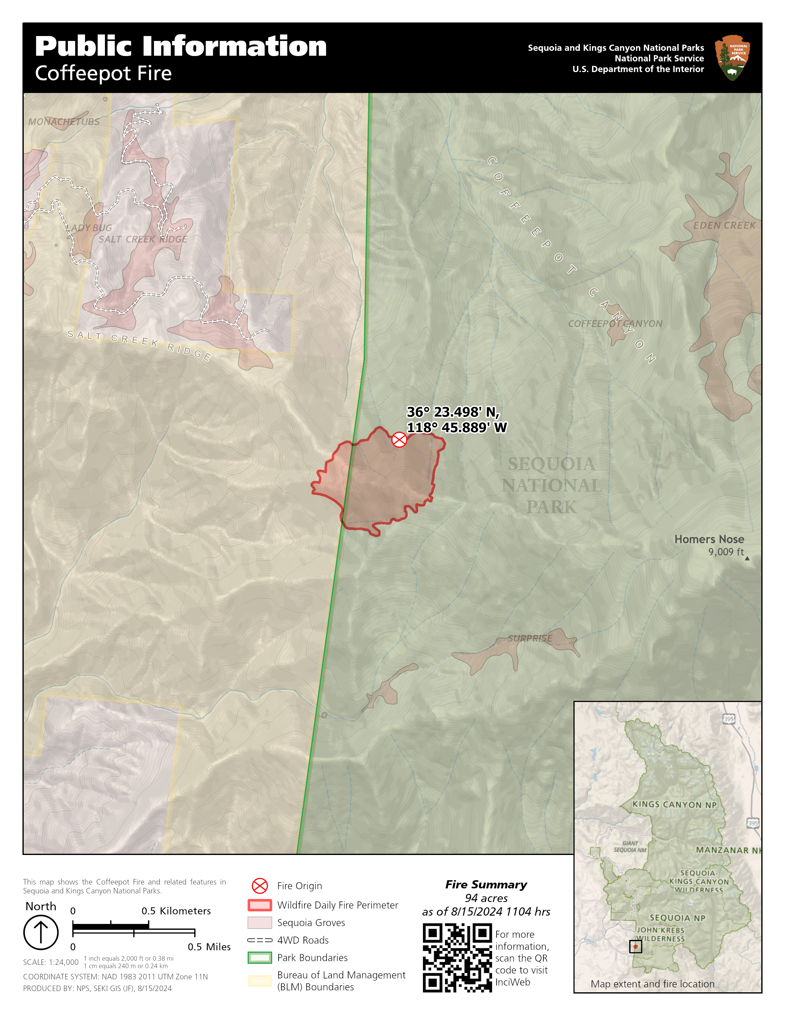
Coffeepot Fire Update 08 15 2024
Related Incident: Coffee Pot Fire
Publication Type: News
Size: 94 Acres
Containment: 0%
Fire Cause: Lightning
The Coffeepot Fire has continued to grow, as expected, slowly down steep terrain that is difficult to access. This afternoon, the fire was estimated to be 94 acres in size. Dedicated crews have been digging hand line close to the perimeter of the fire for the past four days and have encountered several instances of dangerous burning logs rolling downhill. Hand crews will move to areas with higher probabilities of success as aircraft maintains primary support. An incident command team from Nevada will be arriving within the next two days and plan to establish an incident command post in Three Rivers. There remains no immediate threat to the local community. Fire updates continue to be posted daily on the Coffeepot Fire InciWeb page.