
Red Fire Daily Update 08162024 08 16 2024
Related Incident: Red Fire
Publication Type: News
RED FIRE DAILY UPDATE Friday, August 16, 2024 541-208-1766, 2024.red@firenet.gov
https://inciweb.wildfire.gov/incident-information/ordef-red-fire https://www.facebook.com/2024RedFireOR/
Size: 723 acres Location: 5 miles west of Crescent Lake Junction, OR County: Klamath Start Date: July 17, 2024 Cause: Lightning Containment: 0% Total Personnel: 243
Crescent, OR – The Red Fire is burning within the Diamond Peak Wilderness of the Deschutes National Forest, on the southwest slope of Redtop Mountain. The fire is being managed under a full suppression strategy. Public and firefighter safety is the highest priority in managing this fire.
Shaded Fuel Break Phases – Firefighters are completing the shaded fuel break in three phases Phase 1 includes cutting and stacking selected trees using logging equipment; Phase 2 includes limbing, trimming, and removing cut trees off site; and Phase 3 includes masticating brush and tree limbs to remove and reduce vegetation that could be fuel for the fire.
Yesterday’s Activities – Crews progressed further into Phase 1 along the Crescent Lake Summer Homes. Phase 3 was completed near Cabins 64-73 as well as the area from the Snowpark to the Crescent Lake Campground. Firefighters moved 27,000 gallons of water through the established hose lay protecting and prepping values along the lay.
Today’s Activities – Firefighters will continue to remove and clean up woody debris in areas where Phase 3 has been completed. Crews will progress further into Phase 1 along the Crescent Lake Summer Homes area. Along Forest Service Road (FSR) 6010, firefighters will coordinate with resources from the Willamette Complex South Fire to strengthen defensible areas along FSR 6010.
Weather and Smoke – Fire activity is expected to be similar as previous days with continued creeping and smoldering. On the southern end, the fire is expected to continue backing towards the White Fish Creek Trail. Fire behavior will be low to moderate across most of the fire today because of the recent rainfall and erratic and gusty winds from associated the storms. Air quality information can be found at https://fire.airnow.gov/.
Closures – The Deschutes National Forest has implemented an emergency closure around
Crescent Lake and in the Diamond Peak Wilderness. The public should note that Forest Service Road 60 is closed, and road guards have been posted for public safety. More closure information is available at: https://www.fsa.gov/alerts/deschutes/alerts-notices/?aid=89091
Evacuations – The WILDFIRE! Level 1 – BE READY to Evacuate notice issued by Klamath County Emergency Management for the Crescent Lake, Odell Lake, and Crescent Junction areas remains in effect (INCENDIO FORESTAL! Nivel 1 - ESTÉ PREPARADO para evacuar de las siguientes zonas: Crescent Lake, Odell Lake, Crescent Junction). Visit www.klamathcounty.org/300/emergency-management for more information or to sign up for alerts.
Fire Restrictions – Stage 2 Public Use Fire Restrictions – which prohibit open fires, including in developed campgrounds – are in effect for the Deschutes National Forest. The Industrial Fire Precaution Level is currently Level IV “General Shutdown.” Visit fs.usda.gov/detail/deschutes/home/?cid=stelprdb5297376 for more information.
Drone Restrictions – Aerial firefighting is suspended when unauthorized drones (UAS) are in the area. Unauthorized drone use over a fire area poses serious risks to fire personnel and the effectiveness of wildfire suppression operations. If you fly, we can’t.
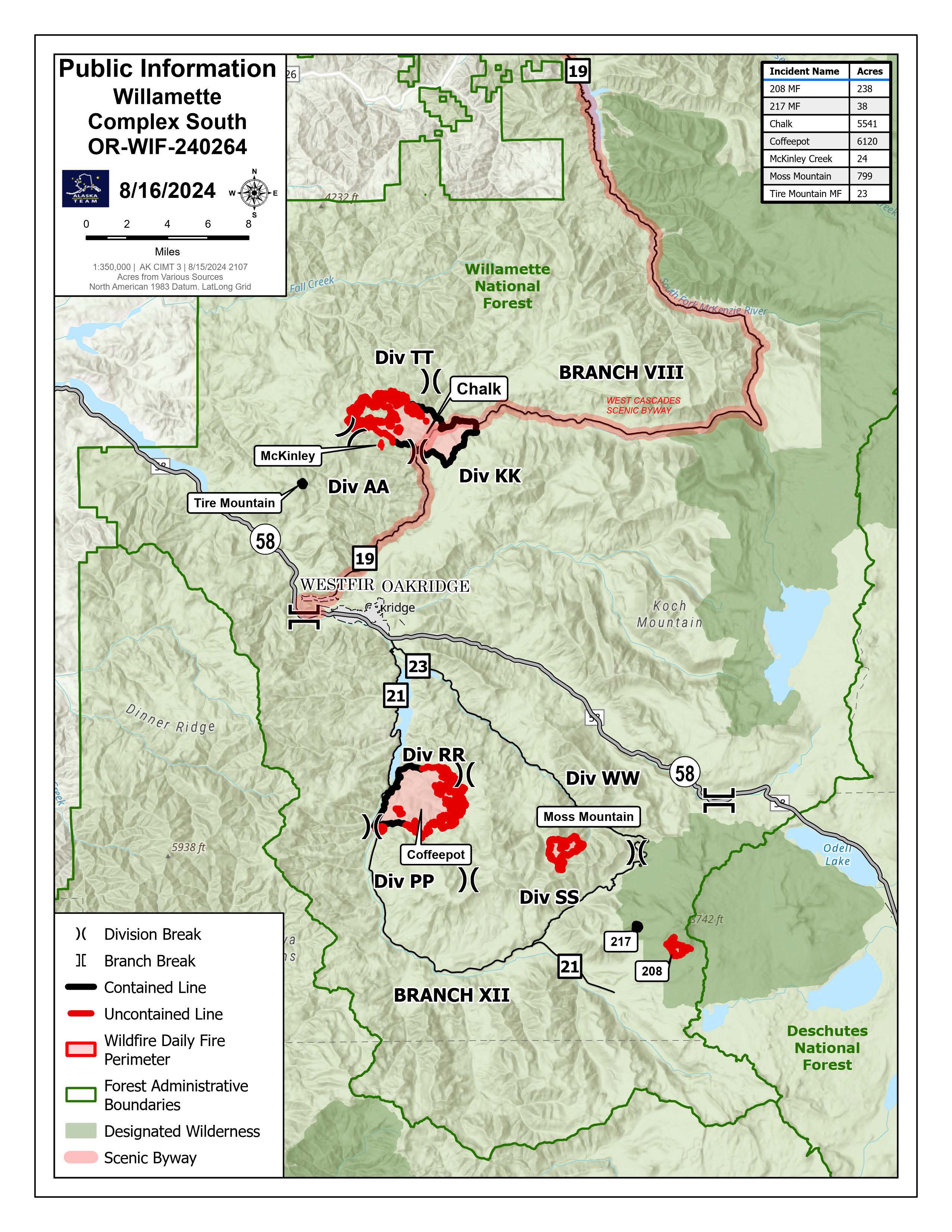
Willamette Complex South Daily Update Friday 08 16 2024
Related Incident: Willamette Complex Fires - South
Publication Type: News
Friday, August 16, 2024
Total Willamette Complex South Personnel: 820
Total Willamette Complex South Acres: 12,783
Resources: 25 Type 6 Engines, 14 Dozers, 10 Masticators, and 1 Skid Steer
Fire Cause: Lightning
Community Meeting TONIGHT!
There will be a community meeting for the Willamette Complex Fires South on Friday, August 16, at 6:30 pm at the Banner Bank Amphitheater in Greenwaters Park in Oakridge, Oregon. A recording of the in-person meeting will be posted to Facebook and YouTube.
Chalk Fire (5,541 acres, 54% containment)
Uncrewed aircraft systems (UAS) are available for use on the Chalk Fire for strategic firing operations, as conditions allow. Firing, or burn-out, operations reduce fuel load so that crews can more safely gain containment line. Equipped with thermal imaging capabilities, these UAS also provide fire managers with temperature mapping to identify the locations of hot spots. This will allow them to pinpoint crew deployment for search and destroy missions to extinguish heat.
Coffeepot Fire (6,120 acres, 35% containment)
Unburned islands of fuel remain on the east side of the Coffeepot Fire, near containment lines. Similar to the Chalk Fire, UAS will be used for firing operations in the green islands. Felling crews are removing hazard trees to widen containment lines. Hazard trees not only pose a hazard to firefighters, but also undermine the effectiveness of the containment line.
Moss Mountain Fire (799 acres, 0% containment)
The Midnight Sun Hotshots and Gila Hotshots, supported by a Type 1 helicopter, are preparing and holding the 2120 road on the south of the Moss Mountain Fire. Hotshot crews are a highly trained, self-sufficient, 20-person unit. Their skills are critical to holding this road in steep terrain, heavy timber, and significant hazards. Additional crews are constructing further control lines aided by heavy equipment.
208 Fire (238 acres, 0% containment)
The 208 Fire remains unstaffed but is patrolled daily. Fire managers are assessing strategic options for protecting private timber lands to the west.
217 Fire, Tire Mountain Fire, and McKinley Fire
The 217, Tire Mountain, and McKinley fires are 100% contained. Crews are monitoring heat and mopping up as conditions allow.
Weather and Fire Behavior
Marine air pushed in on Thursday and raised the humidity levels across the complex. Cooler and moister conditions are expected to remain in place through Saturday, with a gradual return to seasonally normal warmer and drier conditions.
Closures and Fire Restrictions
Area, road, trail, and recreation site closures are in place on the Willamette National Forest in the vicinity of many active fires. Temporary road barricades are in place to restrict traffic across the fire areas.
- For specific closure information visit tinyurl.com/WillFireClosures2024
- For current fire restrictions visit tinyurl.com/WillFireRestrictions2024
Temporary Flight Restrictions (TFR) are in place over the Chalk, Coffeepot, and Moss Mountain Fires. Visit tfr.faa.gov for up-to-date areas. Wildfires are a no-fly zone for unauthorized aircraft, including drones. For more information, visit knowbeforeyoufly.org.
For More Information
Phone: (541) 208-1742, 8 a.m. to 8 p.m.
Email: 2024.willamettecomplex@firenet.gov
InciWeb: https://inciweb.wildfire.gov/incident-information/orwif-willamette-complex-fires-south
Facebook: https://www.facebook.com/WillametteComplexFires
YouTube Channel: https://www.youtube.com/@WillametteComplexFiresSouth
#FireYear2024
Settings - change map background and toggle additional layers
Filter - control incident types displayed on map.
Zoom to your location
Reset map zoom and position
Could not determine your location.
Show Legend
 Wildfire
 Prescribed Fire
 Burned Area
Response
Burned Area
Response Other
Other
Midway Pasture
Unit Information
Incident Contacts
Smoke Outlook for Mid Columbia Gorge Area 08 16 2024
Related Incident: Whisky Creek FireSandstone Fire
Publication Type: Announcement
Fire
The Whisky Creek Fire is currently 1,938 acres. Fire crews continue to dig handlines and hold and secure completed line. Today, winds will be westerly and temperatures in the 60s are expected. The Sandstone Fire is 696 acres. The fire is creeping and smoldering within the perimeter of a wildfire that burned in 2006. Crews are planning to use direct strategies where possible. At the Williams Mine Fire, fire activity has moderated. Over the last day, the fire grew 153 acres to 11,302 acres.
NOTA: Traducido al español utilizando un sistema automatizado. Esto podría introducir errores.
Fuego
El incendio de Whisky Creek actualmente abarca 1,938 acres. Los equipos de bomberos continúan excavando líneas a mano y asegurando y manteniendo las líneas completadas. Hoy, se esperan vientos del oeste y temperaturas en los 60 grados. El incendio de Sandstone es de 696 acres. El fuego está avanzando lentamente y con combustión lenta dentro del perímetro de un incendio forestal que ocurrió en 2006. Los equipos están planeando usar estrategias directas donde sea posible. En el incendio de Williams Mine, la actividad de fuego se ha moderado. Durante el último día, el fuego creció 153 acres hasta alcanzar 11,302 acres.
Smoke
Winds will remain westerly, providing GOOD air quality for most of the outlook area. Localized smoke pooling during overnight and morning hours for the Trout Lake and Glenwood areas will result in poor air quality. There is a likelihood of afternoon/evening rain and thunderstorms on Saturday.
Humo
Los vientos permanecerán del oeste, proporcionando una calidad de aire BUENA para la mayoría del área de pronóstico. La acumulación localizada de humo durante las horas nocturnas y matutinas en las áreas de Trout Lake y Glenwood resultará en una calidad de aire pobre. Existe la probabilidad de lluvia y tormentas eléctricas durante la tarde/anochecer del sábado.
Park Fire Morning Update for August 16 08 16 2024
Related Incident: Park Fire
Publication Type: News
The Park Fire Morning Update for August 16 is posted on the Park Fire Status Update Page
Limepoint Fire Update Friday 08 16 2024
Related Incident: Limepoint Fire
Publication Type: News
Limepoint Fire
Friday, August16, 2024
Contacts for Fire Information: 208-992-3032 or 2024.limepoint@firenet.gov
Limepoint: https://inciweb.wildfire.gov/incident-information/idpaf-limepoint-fire
https://www.facebook.com/payettenationalforest/
On the northern side of the fire near Horse Mountain, suppression efforts continue as firefighters link containment lines and reduce potential for the fire to spread. Crews are taking advantage of favorable conditions by conducting burning operations with air and ground crew support before conditions shift to hot, windy, and dry weather on Saturday.
The Kleinschmidt Grade, the notorious steep and narrow road from Hells Canyon to Cuprum, is being evaluated for the removal of large trees and debris. This road remains closed but is a priority for crews as it serves as an evacuation road out of Hells Canyon.
On the east edge of the fire heat is still being detected in some spots and crews are containing anything that has the potential to burn. Night crews worked vigilantly monitoring and patrolling the fireline keeping the Bear and Cuprum communities safe.
On the southern end of the fire near Barber Flat and Paradise Flat, firefighters continue with repair efforts to help the landscape return to its natural state.
A low-pressure system moved across the fire area and brought lightning and gusty winds yesterday which ignited three new starts on the Payette National Forest. Aerial resources assigned to the Limepoint Fire helped with initial attack.
The Cliff Mountain Fire, located approximately 7 miles north of the Limepoint Fire, is 1,108 acres with 75 percent containment, burning mostly in wilderness will return to Wallowa-Whitman National Forest jurisdiction at 0600.
Evacuations: Evacuation levels continue unchanged. Cuprum remains at a Level 2 (SET) evacuation level, per the Adams County Sheriff. The Bear and Wildhorse communities remainat a Level 1 (READY)evacuation level. For your safety and the safety of firefighters, please stay away from the fire area. Only residents and property owners are allowed in the area until further notice.
Closures: The Forest Closure Order issued by the Payette National Forest to protect public safety near the fire area remains in effect. For more information about the closure, visit https://inciweb.wildfire.gov/incident-information/idpaf-limepoint-fire.
Restrictions: Stage 1 Fire Restrictions remainin effect for the Payette National Forest and all state, private and BLM lands in the fire area. Underthese restrictions, campfires are allowed only in recreation sites within metal fire pits. Fires of any kind are not allowed in any dispersed camping areas.
Special Note: The Council Mountain Music Festival will be held as planned this weekend at Veterans Memorial Peace Park, adjacent to Adams County Fairgrounds in Council. The fairgrounds are serving as the Incident Command Post (ICP) for the Limepoint Fire. Fire managers and festival organizers are coordinating to ensure the enjoyment of festival attendees, and the safety of both festival attendees and fire personnel.
Boise Fire Update August 15 2024 08 16 2024
Related Incident: 2024 Boise Fire
Publication Type: News
Headlines:
- Fire information phone: 707 572-4860 or email at 2024.Boise@firenet.gov
- Get all your Boise Fire information in one mobile-friendly place! https://linktr.ee/2024boisefiresrf
- Join us TODAY for a community meeting in Forks of Salmon at the Community Club at
5 p.m. This meeting will not be livestreamed. - Evacuations are in place for the Boise Fire for residents near the fire area in Humboldt County. For the most current evacuation information please visit the Boise Fire linktree or visit--
- Humboldt County: https://humboldtgov.org/356/Office-of-Emergency-Services
- Siskiyou County: https://www.co.siskiyou.ca.us/emergencyservices
Leader’s Intent: The Boise Fire is being managed with a full suppression strategy.
Operational Update: Last night’s conducive conditions allowed for another good night of work, with crews focusing again on mopping up and securing the north and west sides of the fire.
Much focus has shifted to the south and east sides of the fire where crews will continue today to work directly on the active fires northeast edge from the Orleans Mountain south, taking advantage of the lessened fire activity to cut that off. They will also continue work from Nordheimer Flat south along the ridgeline and north from High Point Ridge to hold the eastern edge of the fire. They are also scouting contingency lines today and looking at options for containment between the proposed handline and the Salmon River and road.
Weather and Fire Behavior: The weather today is anticipated to be much the same as yesterday, with the inversion lifting early- to mid- afternoon. Fire behavior is expected to remain moderated by higher humidity and cooler temperatures. A wetter system is expected to pass through the fire area tomorrow, with a solid chance of wetting rain in the forecast followed by a return to dry and hot conditions.
Warner Peak Fire Daily Update 08 16 2024
Related Incident: Warner Peak Fire
Publication Type: News
Warner Peak Fire Update
Daily Update August 16, 2024
Acres: 65,002 Start Date: 08/05/24
Location: Lake County, OR Personnel: 492
Containment: 51%
Highlights: The fire remained within its footprint, not increasing in acreage. Containment continues to increase as firefighters seek out hot spots and mop-up along the perimeter. While there is minimal fire activity around the eastern perimeter, the fire is still active in the south and west corridors. Crews are taking advantage of today’s moderate weather, as they prepare for high winds forecast for tomorrow.
Fire Activity: On the western perimeter, crews are continuing to strengthen containment lines and seek out hotspots that were detected by infrared (IR) flights. To the south, crews are working diligently to prevent the fire from encroaching Hart Lake and Crump Lake. Firefighters are working on controlling and monitoring fire spread near Hart Mountain Road on the northwest edge of the fire. In addition to the crews engaging the fire on the ground, multiple aviation resources are playing an integral role in establishing containment lines. Fire managers conducted a thorough aerial reconnaissance of the fire perimeter, and it appears yesterday’s Red Flag Warning did not result in any new fire ignitions. The flight confirmed that heat indicated by previous UAS drone flights remains inside the fire perimeter and is not currently threatening containment lines.
Today's priorities will be putting out isolated hotspots throughout the fire as well as patrolling and monitoring the containment lines that have been established. Tomorrow’s weather with the possibility of outflow winds intensifying fire behavior will be closely monitored, especially in areas of unburned vegetation close to the southern border.
Closures: The Hart Mountain National Antelope Refuge is closed for public and firefighter safety.
In coordination with the Southwest Area Incident Management Team, the Lake County Sheriff’s Office has issued evacuation orders for the Hart Mountain area in support of firefighting efforts on the Warner Peak Fire. For detailed information visit www.lakecountyor.org.
Weather: Temperatures are averaging in to the mid 80’s. Relative humidity will remain at 17%. Humidity is showing good recovery at night, climbing to 50%. This recovery should moderate fire activity allowing crews to continue to make progress on suppressing the fire. Fire weather watch is warmer, drier, and windy conditions in the forecast tomorrow.
Smoke: Wildfire smoke from the Warner Peak Fire may impact the community of Plush and surrounding areas.Go to www.airnow.govto see the latest smoke conditions in your community.
More Information:
Information Phone Line: 541.208.1770
Email: 2024.warnerpeak@firenet.gov
Facebook: facebook.com/warnerpeakfire
Inciweb: inciweb.wildfire.gov/incident-information/orshr-warner-peak
Grouse Fire Daily Update 08 16 2024
Related Incident: Grouse
Publication Type: News
Location: 10 miles southwest of Wise River, MT
Start Date: 7/25/2024
Cause: Undetermined
Size: 4,166 acres
Containment: 22%
Resources on Site: 15 engines
Total Personnel: 119
KEY MESSAGES
Rocky Mountain Complex Incident Management Team Three will transfer command of the fire to a Beaverhead-Deerlodge National Forest Type 4 Incident commander at 6:00 p.m. tonight. “Rocky Mountain Team Three was able to build on the strong work started by the Type 3 team before our arrival. We worked closely with the home unit, who provided strong leader’s intent. They identified the critical values at risk that allowed us to focus our work in specific areas. If in the future the fire should want to move, firefighters will have a safe and good line to hold the fire on. We are very thankful for the members of the community of Wise River. They treated us very graciously and made us feel at home,” said Bill Waln, Rocky Mountain Team Three Incident Commander.
A burned landscape presents several safety hazards that either did not exist prior to the fire or have been exacerbated by the effects of the fire. These hazards include unstable soils that allow rocks to dislodge and roll down steep hillsides; fire-weakened trees and snags that can fall over or large limbs breaking away in windy conditions; and stump holes where fire has burned through a tree root system and created cavities that can collapse under your feet. Always remember to be aware of your surroundings and aware of the hazards in a burned area.
CURRENT STATUS/PLANNED ACTIONS
Firefighters will continue to monitor and patrol the fire along the Pettengill Road and Pettengill Creek trail. Crews will continue cleanup and log trucks will continue hauling logs from the shaded fuel breaks along the Pioneer Mountains Scenic Byway.
Weather and Fire Behavior
It will be slightly cooler with temperatures ranging from the low 60s to mid 70s. Southwest winds will be 10-15 mph with gusts up to 20 mph. There’s a 30 percent chance for thunderstorms that could bring wind gusts up to 40 mph.
CLOSURES AND RESTRICTIONS
The Beaverhead-Deerlodge National Forest has issued an Area/Road/Trail Closure (Closure #01-02-03-24-05) effective July 31, 2024. This Order is for public and firefighter safety during fire suppression efforts of the Grouse Fire. Closure information and maps are posted on the Forests’ website and the fire’s Inciweb page as they are in place. https://inciweb.wildfire.gov/incident-information/mtbdf-grouse.
A Temporary Flight Restriction (TFR) is in place over the fire area.
The Forest is in Stage 1 Fire Restrictions. Campfires are allowed only in a permanent metal fire grate/ring provided by the Forest Service in a designated, developed recreation site. Smoking is restricted to vehicles, in buildings, or in an area clear of flammable materials. Devices with an on/off switch that use LPG fuels are allowed in an area clear of flammable materials within three feet of the device.
West Mountain Complex Fires Daily Update 08 16 2024
Related Incident: Dollar Fire Boulder FireWolf Creek Fire
Publication Type: News
The West Mountain Complex includes five fires- Boulder, Snag, Wolf Creek, Dollar, and Goat Fires. Read our daily update for more information. Scroll to the bottom of the page for PDF versions of the daily update, the daily map, and the daily smoke report.
QUICK FACTS
Fire | Location | Size | Containment | Start Date
Boulder | 9 miles SW of Cascade | 1,968 acres | 11% | 7/24/2024
Wolf Creek | 5 miles W of Donnelly | 1,154 acres | 81% | 7/24/2024
Snag | 11 miles E of Cascade | 19,825 acres | 0% | 8/5/2024
Dollar | 18 miles NE of Cascade | 1,675 acres | 0% | 8/5/2024
Goat | 11 miles SE of Cascade | 999 acres | 0% | 8/5/2024
Gabe | 9 miles SW of Cascade | 5-6 acres | 0% | 8/15/2024
Cause: Lightning (All Fires)
Total Incident Personnel: 833
Weather | Anticipated Fire Behavior:
Numerous rain showers and scattered thunderstorms occurred over the fire areas yesterday. Clouds and showers kept the humidity levels higher at around 30% to 40%. Chance of rain showers and thunderstorms will be minimal Friday through the weekend and into early next week. Temperatures on Friday will remain slightly cooler than average, with humidities around 35%. Saturday will bring hot, dry, windy and unstable conditions and a Fire Weather Watch has been issued. Conditions will moderate Sunday and into early next week, but will remain warm, dry, and breezy.
Boulder Fire: https://inciweb.wildfire.gov/incident-information/idbof-boulder-fire
Fire behavior was observed throughout the day yesterday. However, the fire did receive some precipitation with thunderstorms moving through the area. Fire managers are planning for firing operations northwest of the 421E Road when weather conditions become optimal to strengthen the containment line near the road. Firing operations may cause additional smoke impacts.
Snag Fire: https://inciweb.wildfire.gov/incident-information/idbof-snag-fire
The Valley County Sheriff’s Office, in coordination with Great Basin Incident Management Team 2, have established one-way escorts for residents and contractors through the Snag Fire affected areas. This escort will be provided for reasons of necessity and not for recreation purposes. For more information visit: https://www.co.valley.id.us/news/post/1210.
The Snag Fire remains the most active fire of all the fires being managed by the incident management team. Some spot fires were observed on the northern portion of the fire, however fire crews were able to prevent further fire spread. The fire perimeter remains active burning heavy dead and downed fuels, which continues to create challenging conditions for firefighters. Additional firefighting crews have been assigned to the Snag Fire and firefighting activity along the Warm Lake Highway will increase.
Wolf Creek Fire: https://inciweb.wildfire.gov/incident-information/idpaf-wolf-creek-fire
Fire crews observed some fire activity within the northeast perimeter of the fire inside the containment line. Firefighters continue mop-up operations. Mop-up is the process of extinguishing or removing burning material near control lines down to the mineral soil, felling fire damaged trees, and cooling ash pits. As fire activity minimizes, resources will be reassigned to the Snag Fire.
Dollar Fire: https://inciweb.wildfire.gov/incident-information/idbof-dollar-fire
The Dollar Fire is slowly spreading in all directions. However previously burned areas and rocky outcroppings are limiting fire spread. Firefighting crews are currently working to slow fire spread on the southern perimeter of the fire where it is moving toward the North Fork Gold Trailhead and a previously burned area. Aerial resources are continuing to monitor fire behavior.
Goat Fire: https://inciweb.wildfire.gov/incident-information/idbof-goat-fire
Aviation resources are monitoring fire spread to the north toward the Snag Fire and to the east toward the Middle Fork Payette drainage. The western perimeter of the Goat Fire borders a previously burned area, which may slow fire progression. Fire managers are working to assign firefighting crews to the Goat Fire as progress is made on other fires being managed by the incident command team.
Gabe Fire:
A new wildfire was reported at approximately 6 p.m. last night near Snowbank Mountain and Gabe Peak, just northeast of the Boulder Fire. Ground and air resources were immediately dispatched to the wildfire where crews engaged in suppression operations. Throughout the day today, fire crews will be mopping up and monitoring the area to ensure no hot spots or flare-ups occur.
SNAG FIRE EVACUATION INFORMATION
The Valley County Sheriff’s Office issued a “ready” evacuation order for Warm Lake residents and the North Shore Lodge at Warm Lake on August 7. The map can be found on Inciweb: https://tinyurl.com/42auxnk8. A second “ready” evacuation order was issued on August 8 for the Horsethief area, including the YMCA Camp, and areas of Scott Valley. This map can also be found on Inciweb, with the relevant areas outlined in purple: https://tinyurl.com/4vfj657x
Review the READY, SET, GO evacuation procedure for Valley County: https://www.co.valley.id.us/ReadySetGo
For timely information on evacuations, check out your county’s emergency alert system.
• Valley County: https://www.co.valley.id.us/CompleteEmergencyNotificationandAlerting
• Adams County: https://public.alertsense.com/SignUp/PublicUser.aspx?regionid=1077
ROAD CLOSURES
Warm Lake Highway Closure: The Valley County Sheriff’s Office has closed Warm Lake Highway due to the Snag Fire. The Warm Lake Highway is closed at the Horsethief Road intersection east toward Warm Lake and from the Johnson Creek Road intersection west toward Warm Lake. Scott Valley residents will be allowed access. For updates on county closures visit: https://www.co.valley.id.us/departments/SheriffsOffice.
FOREST CLOSURES
August 12, 2024 update: The Boise National Forest has modified or expanded their wildfire closures to address public and firefighter safety and respond to increased wildfire growth. This new closure area begins at the south end of the Dollar/Oro (Snag) fire closure area and continues south to Crouch and the Banks-Lowman Hwy, and east to the 579, 563 and 582 roads. Wolf Creek Fire Closures: On the Payette National Forest, a closure including popular National Forest System roads around the Wolf Creek fire such as: sections of NFS #1763 (West Mountain Jeep Trail), #835, #206, #326. On the Boise National Forest, Forest Road #435 (Anderson Lake Road) was closed on August 1.
Boulder Fire Closures: The Boise National Forest has issued a closure order #0402-04-98 for National Forest System (NFS) roads, trails and lands encompassing the Boulder Fire. The closure was enacted to protect public safety and support fire suppression activities. The closure includes Blue Lake and Snowbank Mountain Road (#446) along with all #404 and #421 system roads. For maps and more detailed descriptions of the closures on the Payette National Forest, please visit: https://www.fs.usda.gov/alerts/payette/alerts-notices For maps and more detailed descriptions of the closures on the Boise National Forest, please visit: https://www.fs.usda.gov/alerts/boise/alerts-notices
Fire Restrictions: Stage 1 Fire Restrictions have been issued for the Payette Fire Restrictions Area on the Payette National Forest and the West Central Mountains Fire Restrictions Area on the Boise National Forest. For more information on the restrictions and a very helpful interactive map, visit https://www.idl.idaho.gov/fire-management/fire-restrictions-finder/
Important Links
• Payette National Forest: https://www.fs.usda.gov/payette
• Payette National Forest Facebook: https://www.facebook.com/PayetteNationalForest
• Boise National Forest: https://www.fs.usda.gov/boise
• Boise National Forest Facebook: https://www.facebook.com/BoiseNationalForest
• Idaho Department of Lands: https://www.idl.idaho.gov/fire-management/