
2620 Road Fire Update 08 15 2024
Related Incident: 2620 Road Fire
Publication Type: News
Road 2620 Fire
Incident Commander: Kent Stanford
Facebook: www.facebook.com/WWIMT
1:30 PM, August 15, 2024
Estimated size: 150 acres
Containment: 0%
Start Date/Time: 8/14/2024 at 5:00 PM
Area of Origin: West of Brinnon, North of Duckabush Rd. on Mt. Jupiter
Cause: Undetermined
Structures Damaged: None
Road Closures: Duckabush Road is closed allowing for residential access only.
Evacuation Levels: The 2500 Block and above of Duckabush Road is at a Level 2. Mt. Jupiter is at a Level 1 alert for the entire Duckabush area.
Level 1 “GET READY” Be aware of the danger in your area and start preparing for possible evacuation. Monitor local media and check on neighbors. If you do not already have an evacuation plan or a Go! kit, assemble these now. Conditions can change suddenly, and you may not receive a Level 2 "Be Set” warning before you are ordered to Level 3 “Go!” Prepare both the inside and outside of your home for fire. Leave if you feel unsafe -- do not wait for an official evacuation order.
Level 2 “GET SET” Be prepared for sudden or short-notice evacuation. People who need help or more time to evacuate -- such as people with disabilities, people with small children, people with medical conditions, and people with large animals -- should evacuate now. Ensure your evacuation plan checklist is complete and your Go! kit is in your vehicle. Stay informed and be aware of alerts from local law enforcement and fire departments. Always remember to leave if you feel unsafe, do not wait for an official evacuation order.
Level 3 “GO NOW” Go now! Danger in your area is current or imminent and you should evacuate immediately. Follow directions from law enforcement or fire departments and do not return home until officials have determined it is safe. Notification it is safe to return home will be given as soon as possible.
Update: Road 2620 Fire started Wednesday, August 14, 2024 at 5:00 PM. The fire is burning in a recently logged area with steep terrain and heavy fuels. There are two helicopters and two scoopers dropping water on the fire. Crews on the ground are working to place lines around the homes for protection.
Air Space Restrictions: There is a Temporary Flight Restriction (TFR) in place over the fire. If you fly, we can’t.
Sheltering: There are no shelters at this time.
###
Settings - change map background and toggle additional layers
Filter - control incident types displayed on map.
Zoom to your location
Reset map zoom and position
Could not determine your location.
Show Legend
 Wildfire
 Prescribed Fire
 Burned Area
Response
Burned Area
Response Other
Other
2620 Road Fire
Unit Information
Incident Contacts
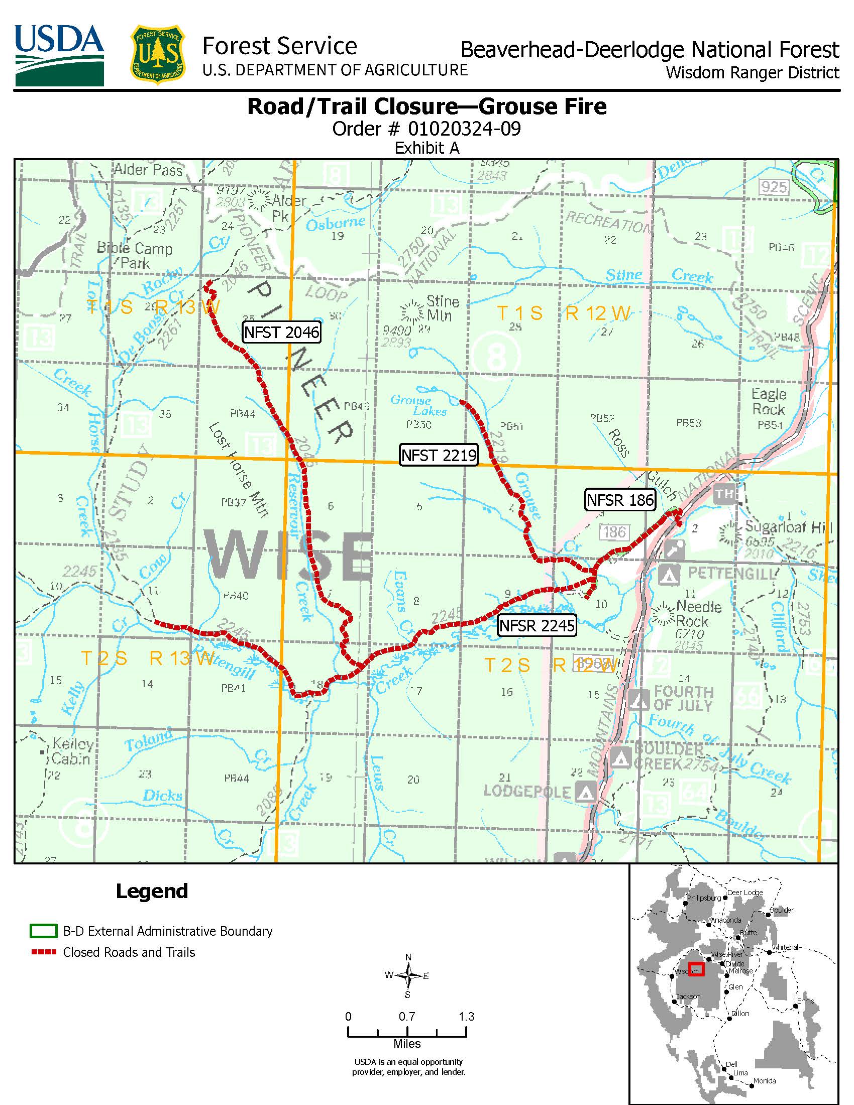
Grouse Fire RoadTrail Closure Order 08 16 2024
Related Incident: Grouse
Publication Type: Closures
Order Number: # 01020324-09
U.S. Department of Agriculture, U.S. Forest Service Beaverhead-Deerlodge National Forest
Wisdom Ranger District
Road/Trail Closure—Grouse Fire
PROHIBITIONS
Pursuant to 16 U.S.C. § 551 and 36 C.F.R. § 261.50 (b) the following are prohibited on the National Forest System (NFS) roads and trails in the Wisdom Ranger District, Beaverhead-Deerlodge National Forest, described below and shown on the attached map incorporated into this Order as Exhibit A (Described Roads/Trails):
- Being on the trail. 36 C.F.R. § 261.55(a).
- Being on the road. 36 C.F.R. § 261.54(e).
EXEMPTIONS
Pursuant to 36 C.F.R. § 261.50(e), the following persons are exempt from this Order:
- Owners or lessees of land in the area.
- Persons with Forest Service Permit No. FS-7700-48 (Permit for Use of Roads, Trails, or Areas Restricted by Regulation or Order), specifically exempting them from this Order or a written determination by a Forest Service authorized officer that a permit is not required under 36 C.F.R. § 251.50(e)(1) or (2).
- Any Federal, State, or Local Officer, or member of an organized rescue or firefighting resource in the performance of an official duty.
DESCRIBED AREA/ROADS/TRAILS
The closure applies to the following National Forest System (NFS) roads and trails, depicted on the attached map (Exhibit A).
- Trail Closures. All miles of the following National Forest System Trails (NFSTs) in the Wisdom Ranger District:
- NFST #2219 Grouse Lakes trail, entire length 2.9 miles
- NFST #2046 Reservoir Creek trail, entire length 6.0 miles to the junction with NFST #2261 DeBoose Creek trail.
- Road Closures. The following National Forest System Roads (NFSRs) in the Wisdom Ranger District.
- NFSR #186 for its entire length
- NFSR #2245 Pattengill for approximately 6 miles beginning at NFSR #186 and ending at the junction with NFST #2135 Lost Horse Creek trail.
PURPOSE
The purpose of this Order is for public safety due to wildfire and active fire suppression activities.
IMPLEMENTATION
- This Order shall be in effect from 12:01 a.m. on August 17, 2024, through October 15, 2024 at 12:01 a.m. unless rescinded.
- A map identifying the Described Roads/Trails is attached and made part of this Order as Exhibit A. For a digital version of this Order and Exhibit A, go to https://www.fs.usda.gov/alerts/bdnf/alerts-notices .
- Unless otherwise expressly defined in this Order, the terms used in this Order are defined by the regulations of the Secretary of Agriculture, 36 C.F.R. Chapter II, Parts 200-299. If there are terms in this Order that are not expressly defined in the Order or 36 C.F.R. Chapter II, Parts 200-299, their meaning shall be determined by their plain language definitions.
- A violation of the above prohibitions is punishable as a Class B misdemeanor by a fine of not more than $5,000 for individuals and $10,000 for organizations, or by imprisonment for not more than six months, or both. 16 U.S.C. § 551; 18 U.S.C.
§§ 3559, 3571, and 3581.
- Contact the Wisdom Ranger District in Wisdom, MT (406) 689-3243, and Beaverhead-Deerlodge National Forest Supervisor’s Office in Dillon, MT, (406) 683-3900, for more information about this Order.
- This Order supersedes any previous Orders prohibiting the same or similar acts on the same Described Roads/Trails.
Signed and issued on August 16, 2024
Alfred Watson
Forest Supervisor
Beaverhead-Deerlodge National Forest
Speirs Fire Update August 16 08 16 2024
Related Incident: Speirs Fire
Publication Type: News
Speirs Fire Update - August 16, 2024
Some Routes Reopen as Progress Continues on Development of Contingency Line
Current Status - The Speirs Fire remains at 715 acres and 97 percent contained.
Updates – Progress continues in development of the contingency line south of the fire perimeter. Crews have completed a substantial portion of the line, allowing for an update to the temporary fire closure, reopening some routes. The new closure includes only the Greens Draw Road (Forest Service Road 049), releasing all trails previously closed and opening them for public use.
Heavy equipment continues to operate within the contingency line area. While trails within the previous closure area are now open, fire management officials urge persons nearing any area where construction may still be occurring to use extra caution and stay clear from these operations.
The fire area received wetting rain through most of last week, resulting in minimal fire activity. Some isolated areas of smoke and heat remain within the fire perimeter. These conditions may persist for a considerable time, and smoke may be visible as isolated pockets of vegetation burn within the fire perimeter. Firefighters continue to monitor and patrol the area.
As conditions on the fire remain somewhat static, only periodic updates will be provided or as the fire situation changes.
Closures - The following roads and trails remain closed to public access.
- Forest Service Road (FSR) 049 (Greens Draw Road)
- For more information and to view the existing closures, please visit the Ashley National Forest website at https://www.fs.usda.gov/alerts/ashley/alerts-notices
![]()
For more information about the Speirs Fire visit the QR-Code shown
Speirs Fire Temporary Road Closure Update August 16 08 16 2024
Related Incident: Speirs Fire
Publication Type: Closures
The temporary fire closure for the Speirs Fire has been updated on August 16, 2024 to include only Forest Service Road 049 (Greens Draw Road). Other routes and trails previously closed as part of the preceding order have been reopened.
Settings - change map background and toggle additional layers
Filter - control incident types displayed on map.
Zoom to your location
Reset map zoom and position
Could not determine your location.
Show Legend
- Wildfire
- Prescribed Fire
- Burned Area
Response
- Other
Red Creek Fire
Unit Information
Incident Contacts
Midway Pasture Daily Update 08 16 2024
Related Incident: Midway Pasture
Publication Type: News
Midway Pasture Fire Daily Update
Friday, August 16, 2024
August 16, 2024
Size: 1,128 acres
Containment: 100%
Date Started: August 15, 2024
Cause: Undetermined
Structures: At this time crews have not identified any damaged structures.
Evacuations: There are no evacuations in place at this time.
The Midway Pasture Fire started on August 15th, 2024 approximately 15 miles south of Vernon, Texas. Local fire departments initially responded to this fire and requested assistance from Texas A&M Forest Service to provide additional engines and heavy Equipment on August 15th at 7:20PM.
Closures: There are no road closures at this time.
Yesterday: Firefighters from Texas A&M Forest Service worked through the night after arriving around 9:00PM to the scene. The fire burned irregularly and spread quickly through the night as crews diligently worked to secure breaks in the grass and brush fuel. By 4:00 AM, there was 80% containment from engines and heavy equipment creating fuel break lines.
Today: Resources were back on scene today to complete the containment of the Midway Pasture Fire. Crews used heavy equipment and engines to complete the fuel break lines and control the hotter areas of the burn. By 12:40 PM, all crews were released from the scene to staff for any further fires in the region.
Weather and Fire Behavior: Temperatures are forecasted to be in the triple digits starting today which will dry grass and brush, potentially making them more available for fires. Relative humidities will be low but remain above the critical threshold.
Fire Information
Kate Faris Information Officer
Public Information Officer, Texas A&M Forest Service Texas A&M Forest Service
Email: kate.faris@tfs.tamu.edu information@tfs.tamu.edu
Phone: 979-533-5527 979-255-0591
Inciweb: https://inciweb.wildfire.gov/incident-information/txtxs-paint-crossing
Facebook: https://www.facebook.com/AllHazardsTFS
Twitter: https://twitter.com/AllHazardsTFS
Kachess Complex Fire Update August 16th 2024 08 16 2024
Related Incident: Kachess Complex
Publication Type: News
Kachess Complex Fire Update
August 16th, 2024
Incident Information and Media Contact:
2024.kachesscomplex@firenet.gov
+1 509-213-5804
Reported date: August 9th &10th, 2024
Cause: Lightning
Total complex size: ~22
Personnel: 192
Fuels: Timber, timber litter, timber understory Strategy: Full Suppression
Fire behavior: Smoldering, creeping
CLE ELUM, Washington: The Kachess Complex, a group of three lightning-sparked fires, started in the Cle Elum Ranger District of the Okanogan-Wenatchee National Forest between August 9 and 10, 2024. Fire fighters and aviation resources have been working tireless to contain the three fires in very difficult to access terrain. A REMS team (Rapid Extraction Module) have been staged on the Stave Creek Fire to assist in medical extraction if an injury were to occur. A dozer line was recently built off an existing road system as an alternate extraction method in the event of an emergency.
The Kachess Complex Includes:
- Stave Creek Fire: Approximately 12 acres and 0% contained located on steep, rugged, and remote terrain. Firefighters have been reinforcing the eastern flank and exploring different strategies for safely containing the western flank. Due to the remote location of the Stave Creek Fire, a dozer line has been built to enable firefighter access in emergencies if aircraft cannot be used. Aerial bucket drops will keep targeting the fire as weather conditions permit.
- Thomas Fire: Currently 9 acres and 76% contained. Firefighters completed mop-up operations and grided the entire fire for heat. Yesterday afternoon all 48 personnel that were inserted on the Thomas fire for multiple days were extracted safely via helicopter. A recon flight is scheduled today to monitor for any remaining smoke.
- Waptus: Currently one half acre and 100% contained. All fire personnel were extracted via helicopter Wednesday afternoon.
Weather: Showers and thunderstorms are predicted for Saturday afternoon into Sunday morning in the fire area. A flood watch will be in effect Saturday afternoon for areas within a wildfire burn scar. Marine layers settling over the fire may inhibit aerial operations today.
Location: On the Okanogan-Wenatchee National Forest northwest of Cle Elum. The Stave Creek and Thomas fires are between Kachess and Cle Elum Lake. The Waptus fire is further north in the wilderness near Waptus Lake.
Safety: The health and safety of firefighters and the public are always the top priority. Members of the public should avoid the Kachess Complex area. A new TFR (temporary flight restriction) is in effect around the fire otherwise noted. Unmanned aircraft such as drones pose a serious risk to firefighting and can cause air operations to cease. The public is reminded that “If you fly, we can’t!”.
Temporary flight restriction: https://tfr.faa.gov/save_pages/detail_4_0223.html
Closures: There are no closures in place for the Kachess Complex, however, the public is encouraged to avoid the surrounding trails of the Stave Creek and Thomas Fires. Fire restrictions are in effect on the Cle Elum Ranger District, for additional information visit: https://www.fs.usda.gov/detail/okawen/alerts-notices/?cid=fsbdev3_053600 .
Crazy Creek Fire Daily Update for August 16 2024 08 16 2024
Related Incident: Crazy Creek
Publication Type: News
+ California Incident Management Team TEAM 1 – JOHN GOSS– INCIDENT COMMANDER
Minimal growth to Crazy Creek Fire during red flag warning
Daily Update August 16, 2024
Fire Information Phone: 541-208-1768 (8 a.m.-8 p.m.) Email: 2024.crazycreek@firenet.gov Acres:
Crazy Creek – 86,893; 79% contained Kitty Creek – 73; 100% contained
Location: Crazy Creek: 5 miles north of Paulina, Oregon; 498/Kitty Creek: 7 miles south of Mitchell, Oregon
Start Date: July 22, 2024 Personnel: 637 Resources: 18 crews | 0 helicopters | 32 engines | 10 bulldozers | 19 water tenders | 1 masticator | 13 skid steers
Highlights: Despite a red flag warning and midday thunderstorms passing over the Crazy Creek Fire Aug. 15, acreage burned only grew by 23 acres for a total of 86,893 acres. Containment now stands at 79 percent.
The National Weather Service had issued a red flag warning in and around the Crazy Creek Fire until 11 p.m., but thunderstorms produced minimal lightning and winds. Red flag warnings indicate weather conditions conducive for facilitating active fire behavior.
What lightning was observed all fell within the fire’s containment lines. For a second day in a row, between .10 to .20 inches of rain fell, fortifying smaller-diameter vegetation and debris with additional moisture and resulting in a decrease in heat emitting from larger-diameter materials, according to infrared monitoring.
Firefighters will patrol the fire’s perimeter and extinguish interior hot spots, particularly stumps and downed logs near patches of unburned vegetation. Crews will also begin repairing or rehabilitating damage to the landscape caused by suppression activities to reduce the likelihood of erosion or negative impacts to resources.
Evacuations: The Crook County Sheriff’s Office has lowered the evacuation level from Level 3 (recommended evacuation) to Level 2 (set for evacuation) from Highway 380 north to SE Puett Road. The area north of SE Puett Road around the perimeter of the fire remains at a Level 3. The area south of Highway 380 has been lowered to Level 1 (prepare for possible evacuation). An evacuation map is available online through the Crook County Emergency Management Office website.
Weather: Today and into next week hot, dry weather will persist throughout the area with temperatures in the high 80s to low 90s, light winds gusting to 21 mph and low humidity.
Importance of Fire Prevention: All public lands in Central Oregon, including the Ochoco National Forest, are in Stage 2 Public Use (Fire) Restrictions. All open flames, including woodstoves and charcoal briquette fires, are prohibited. In times of high fire danger, it is crucial for everyone to follow prevention measures to avoid additional strain on overburdened resources.
Fire Restrictions and Closures: The Ochoco National Forest has implemented a forest closure for the eastern portion of the Paulina Ranger District. The Bureau of Land Management has issued a temporary closure for portions of public lands in Crook and Grant Counties.
More Information: InciWeb: https://inciweb.wildfire.gov/incident-information/orocf-crazy-creek Facebook: Facebook.com/Crazy Creek Fire Central Oregon Wildfire Information: https://centraloregonfire.org
Resource Advisors on the Park Fire 08 16 2024
Related Incident: Park Fire
Publication Type: Announcement
On the Park Fire, resource advisors (READs) have a unique role as local natural and cultural resource specialists. READs identify and analyze the effects that wildfire, and the resultant suppression efforts, has on these valuable natural and cultural resources, and determine guidelines for firefighters to minimize and mitigation these impacts. Their knowledge of the local area and of resource management plans is critical to protecting these resources.
Jake Martin, lead READ from the Lassen National Forest for the Park Fire Fire, communicates what resource protection measures are required to the incident commander. “On this fire, we’re specifically working to mitigate impacts to species of concern, like the marten, anadromous fish, California spotted owl and Sierra Nevada yellow-legged frog. We are also evaluating fire effects on natural and cultural resources in the Ishi Wilderness,” said Martin.
During large incidents, resource advisors from other parts of the country are brought in to assist local personnel. READ Brad Allen from the Lincoln National Forest spends his day working alongside firefighters, checking for resource concerns ahead of disturbance, such as building fires lines with equipment or digging hand line. “We try to come up with options that are going to work both tactically and minimize impact on resources,” said Allen.
READS typically have a professional specialty such as wildlife, botany, or archeology. Many have firefighting qualifications to work near the fire line (a REAF is a resource advisor, fireline qualified). Although READs’ work to protect important resources, human safety and protecting property remain the top priorities suppressing the Park Fire.