
Ruby Fire Daily Update and Map 08 17 2024
Related Incident: Ruby Fire
Publication Type: News
August 17th, 2024
Minnesota Incident Command System (MNICS) Incident Commander-Jeb Backe
Ruby Fire Quick Facts
Size: 820 acres Location: North Cascades National Park, Ruby Mountain, Diablo, Washington
Containment: 0% Cause: Lightning/Natural
Start Date: August 9th, 2024 Total Personnel: 88
Fire Information:
Inciweb: https://inciweb.wildfire.gov/incident-information/wancp-ruby-fire Email: 2024.Ruby@firenet.gov
Facebook: https://www.facebook.com/people/Ruby-Fire/61563760546137/ Phone: 1-360-208-8096
Current Status: Firefighters continue protection of park infrastructure around wooden bridges, campgrounds, and trail features. Fire access is difficult due to steep terrain and hazards. It is burning in timber and brush. Incident managers conducted an aerial reconnaissance flight to analyze the fire. Fire managers developed trigger points and are assembling firefighting gear in preparation of possible fire growth due to weather.
Planned Actions: Firefighters will continue to work to protect values at risk in the fire area through structure protection and around critical infrastructure, park campgrounds, trail infrastructure, backcountry camps, and other resources in preparation of fire growth. The Ruby Fire is a full suppression fire, and firefighters are utilizing strategies and tactics that provide the highest likelihood for success, while mitigating risks to firefighters and the public. Firefighting strategies and tactics are based on the availability of air and ground resources across the country due to numerous ongoing fires throughout the west. Main objectives are protecting human life, minimizing damage to values at risk, and limiting wildfire spread to the north and west.
Weather: Saturday, sunny skies and warm with highs in the mid-80s. Winds out of the SE 4-8 mph gusting up to 15 mph. Saturday evening, cloudy with rain showers and thunderstorms, Flash Flood Watch 5pm Sat to 8am Sun. Low chance for heavy rainfall resulting in flash flooding and low chance for severe winds. Overnight lows in the low 60s with winds of 6-12 mph gusting up to 20 mph.
Closures: There are multiple closures in the area due to the Ruby Fire and other nearby fires. Closures are in place for public safety. Colonial Creek South Campground and boat launch are closed. State Route 20 is closed east of the park from MP 148 and MP 157 due to the Easy Fire. For a full list of park closures visit https://go.nps.gov/fireclosures .
Burning Restrictions: National Park Service - Campfires or the ignition of wood, briquettes, or any fuel in fire pits, fire pans and barbeque grills, are banned in all portions of North Cascades National Park Service Complex – North Cascades National Park, Ross Lake National Recreation Area, and Lake Chelan National Recreation Area. This includes all National Park Service lands and campgrounds along State Route 20 as well as Hozomeen and the entire Stehekin Valley.
Cooperating Agencies & Tribes: National Park Service, Upper Skagit Indian Tribe, Seattle City Light, Whatcom County, Whatcom County Sheriff’s Office
Smoke: U.S. Interagency Wildland Fire Air Quality Response Program - Overall air quality will be good today in upper Skagit Valley. https://outlooks.wildlandfiresmoke.net/outlook/f79a6d6d https://www.airnow.gov/
If you would like to sign up for our daily updates, please send an email to: 2024.Ruby@firenet.gov
Willamette Complex North Ore Pyramid Daily Update 08 17 2024
Related Incident: North Willamette Complex
Publication Type: News
Willamette Complex North
Ore & Pyramid Fires
Incident Update
Date: Saturday, August 17, 2024
CURRENT SITUATION
Today is expected to be a critical weather day, with warm and dry conditions anticipated in the morning, followed by strong to severe thunderstorms (including erratic winds, hail and flash flooding) across the fire area this afternoon. Crews will remain strategically placed around the fire area for the extreme weather event and will engage when it is safe to do so. Protecting the life of the pubic and firefighters is the highest priority of the incident.
WEATHER AND FIRE BEHAVIOR
Elevated weather conditions will start early today with poor humidity recoveries. Strong clearing and smoke transport in the morning will allow for rapid warming and drying. Winds will increase through the early afternoon with gusts up to 20 mph. Strong to severe thunderstorms are expected in the afternoon. If storms move over the fire, hail up to 1 inch in size is possible, alongside heavy rain and erratic wind gusts in excess of 60 mph. Strong, erratic winds pose multiple hazards due to fire behavior and fire weakened trees. Predicted maximum temperature is 80 to 84 °F in the valleys and 76 to 80 °F on the ridgetops. Predicted minimum relative humidity is 32 to 38% in the valleys and 42 to 48% on the ridgetops. For smoke and air quality conditions visit: AirNow.gov
Ore Fire
Blue River, 3,036 Acres, 13% Contained, 457 Total Personnel, Cause Under Investigation
Yesterday, crews continued conducting burnout operations to prepare indirect line—with the goal of containing the fire at the 1509 and 827 Roads. Crews continued to patrol the Ore Fire overnight, observing active fire behavior within existing containment lines.
Pyramid Fire
East of Middle Santiam Wilderness, 1,320 Acres, 76% Contained, 243 Total Personnel, Lightning Caused
Crews and heavy equipment continue to hold and improve fire lines, patrol the fire perimeter, and conduct mop up. Pockets of intense and scattered heat continue to be identified in the interior of the Pyramid Fire by infrared technology.
Evacuations, Closures & Fire Restrictions
On July 17th, the Linn County Sheriff’s Office, in coordination with the Willamette National Forest, issued a Level 3: Go Now Evacuation Alert for the closure area affected. Please refer to the Linn County Fire Map tinyurl.com/LinnCoFireMap for full details of the issued evacuation area (which will appear in red). To sign up for evacuation alerts, visit linnsheriff.org/.
Area, road, trail, and recreation site closures are in effect in the Willamette National Forest.
Specific information is posted at https://www.fs.usda.gov/alerts/willamette/alerts-notices/?aid=61574.
Fire restrictions are in effect for Willamette National Forest. Read the complete restrictions at: https://www.fs.usda.gov/alerts/willamette/alerts-notices/?aid=81487.
Wildfires are a no-fly zone for unauthorized aircraft, including drones. If you fly, we can’t.
For more information, visit http://knowbeforeyoufly.org
Diamond Complex and Middle Fork Daily Update 08 17 2024
Related Incident: Middle Fork Fire
Publication Type: News
The Diamond Complex on the Umpqua National Forest consists of 28 lightning-caused fires totaling approximately 10,843 acres, with 823 people assigned. The Middle Fork Fire in the northwest corner of Crater Lake National Park has 59 people assigned, and the Diamond Complex is sharing resources as needed. The park remains open.
Transfer of command of the Diamond Complex and Middle Fork Fire from Northern Rockies Complex Incident Management Team 3 to California Complex Incident Management Team 4 at 0600 Sunday.
KEY MESSAGES: A red flag warning for lightning and strong winds is in place today.
For public and firefighter safety, the North Entrance Road in the park is temporarily closed for firefighters to prepare control lines with machinery along that road. For details, visit https://www.nps.gov/crla/learn/news/crater-lake-temporarily-closes-north-entrance-for-the-middle-fork-fire.htm
Seventeen of the 28 fires in the Diamond Complex are now 100 percent contained.
OPERATIONS:
Middle Fork Fire (5,197 acres, 0% contained): A Type 3 helicopter dropped a few buckets of water to cool the southern flank of the fire Friday. Fuel reduction was completed along roads and trails on the west of the fire. Road preparation continues along the Wizard Creek Snowmobile Trail. At the North Entrance to Crater Lake National Park, crews and equipment operators are slowly moving south along the North Entrance Road, clearing vegetation with a specialized machine called a “Spider”. A hand crew is also cutting out some of the smaller diameter vegetation adjacent to the road. A hand crew will widen the Burnt Creek Trail corridor to create a control line.
Yesterday was another mild day for fire behavior. However, red flag conditions for strong outflow winds associated with thunderstorms today are likely to induce increased fire behavior. Air resources, including helicopters for water bucket drops and reconnaissance flights and unmanned aircraft systems (UAS, or drones) for infrared imaging and firing operations remain available. The Pacific Crest Trail from the Dutton Ridge Intersection to Hwy 138, Lightning Springs, Bald Crater Loop, Bert Creek, and Boundary Springs Trails (within the park) are closed. Hikers may not use the North Entrance Road to enter or leave Crater Lake National Park.
Diamond Complex Fires
Pine Bench Fire (North of Hwy 138 near Dry Creek, 3,706 acres, 30% contained): Crews continue to line and mop-up a spot between Medicine Creek and Slide Creek and the fire remains active around Camel Hump. Heavy helicopters supported the firefighters with water bucket drops. Additional hotshot crews will be working the problem areas on that southeast edge of the fire today. The 3402 Road is currently being prepared as a control line, which involves fuel reduction and widening.
Potter Fire (North of Hwy 138, two miles southeast of Potter Mountain, 3,040 acres, 4% contained): A Hotshot crew reinforced indirect dozer line on the east side, and heavy helicopters supported firefighters with water bucket drops. On the northwest flank, crews were building handline around a slopover in the Staley Creek drainage and will continue mopping that up today.
Trep Fire (About four miles south of Hwy 138, 511 acres, 0% contained): Near the southwest corner of Trep, firefighters are building handline down to Bear Trap Meadows. Road preparation continues on the 230 Road.
Ooya Fire (North of Hwy 138, one mile northeast of Bird Point, 372 acres, 37% contained): Skidgines are supplying water to support the mop-up efforts. Masticating along the 2610 Road to the southwest past Bird Point will continue to create a contingency line.
Brodie Fire (Five miles south of Hwy 138, south of Devils Canyon, 220 acres, 90% contained): Firefighters are constructing direct handline on the western edge of the fire. Crews doing mop-up are being supported with water pumped from Skookum Lake.
Lemolo Fire (North of Lemolo Lake on Bunker Hill, 1,246 acres, 46% contained): Mop-up continues and backhaul of equipment is underway for redistribution to other fires in the complex.
Trail Fire (East of Hwy 138 on the west slope of Mt. Thielsen, 842 acres, 77% contained): Firefighters are mopping up in heavy duff and securing the eastern edge into the Mount Thielsen Wilderness.
Lost Fire (Northeast of Trep Fire, 63 acres, 0% contained): Direct handline is being constructed. The 4800 Road is being prepped and opened for mastication to create a fuel break and contingency control line.
Trap Fire (One mile south of Hwy 138 near Trap Mountain, 17 acres, 0% contained): Crews are constructing fuel breaks along existing roads in the Bear Creek Canyon as a contingency line for this group of fires.
Maple Fire (.2 acres, 0% containment): Firefighters are lining and mopping this small fire.
Other fires within the Diamond Complex:
Loafer Fire (44 acres, 56% contained)
WEATHER AND FIRE BEHAVIOR: Heavy lightning and rain with strong winds are expected. Hail is also a possibility. Fire behavior will increase if winds precede the rain.
SMOKE OUTLOOK: Smoke has returned to the area and may reduce visibility and hinder air operations. For the most up to date information, please visit fire.airnow.gov/
CLOSURES, RESTRICTIONS, EVACUATIONS: The Umpqua National Forest has a closure in place affecting the Diamond Lake Ranger District. Most of the Diamond Lake Ranger District is closed. Closure Orders and maps can be found here: www.fs.usda.gov/alerts/umpqua/alerts-notices. Fire danger is set at VERY HIGH, and Public Use Restrictions Level 3 ORDER NO. 06-15-24-04 is in effect: https://tinyurl.com/PublicUseRestrictions
The Rogue River-Siskiyou National Forest has issued a closure for the area north and west of Crater Lake National Forest along Highway 230 south to the intersection with Highway 62. See the Closure Order and map at https://bit.ly/RRSNFAlerts
The Douglas County Sheriff’s Office has lifted evacuation orders for all areas except for east of the Pine Bench Fire, which remains at a Level 1: BE SET for a single residence east of the Potter Fire. For an interactive map of evacuations, visit the Douglas Co. Sheriff’s Office website: www.dcso.com/evacuations
Settings - change map background and toggle additional layers
Filter - control incident types displayed on map.
Zoom to your location
Reset map zoom and position
Could not determine your location.
Show Legend
 Wildfire
 Prescribed Fire
 Burned Area
Response
Burned Area
Response Other
Other
Dirt Road Fire
Unit Information
Incident Contacts
Dixon Fire Morning Update 8172024 08 17 2024
Related Incident: Dixon Fire
Publication Type: News
Containment More than Doubles on Dixon Fire
DAYS CREEK, Ore. – Containment on the Dixon Fire increased from 11% to 23% last night. This was possible due to the around-the-clock efforts of fire responders. “Having a 24/7 operation has been absolutely crucial to our success in catching this fire and keeping it from growing”, said Operations Section Chief Adam Sinkey. Crews worked hard overnight to identify hot spots and further deepen mop up ahead of anticipated stormy conditions. Snags continued to burn and fall, creating hazards and keeping firefighters busy.
With rain and winds forecast, some dozer trails and roads could become difficult or impossible to access. A Red Flag Warning for abundant lightning is in effect from 1 to 9 pm today. Thunderstorms are expected to begin around 2 pm. There is potential for up to a half an inch of rain, strong winds, and hail. However, fuels remain dry in many places, and rain may not consistently penetrate tree canopies to wet the ground. Gusty winds can also spread fire rapidly. Resources are prepared for quick response to any new ignitions.
Evacuations: Evacuation levels are managed by the Douglas County
Sheriff. Please stay up to date on evacuation levels at:
http://www.dcso.com/evacuations
Fire Prevention: Know Before You Go - It Only Takes One Spark.
Public and industrial restrictions are in place to help prevent wildfires:
• Umpqua National
Forest: https://www.fs.usda.gov/main/umpqua/fire
• Oregon Department of
Forestry: https://www.oregon.gov/odf/fire/pages/restrictions.aspx
• Douglas Forest Protective Association: https://www.dfpa.net/publicfire-
restrictions
Road Update: The Tiller Trail Highway is open; however, with the severe weather forecast, check conditions before you travel. Use Tripcheck to plan ahead: https://tripcheck.com/
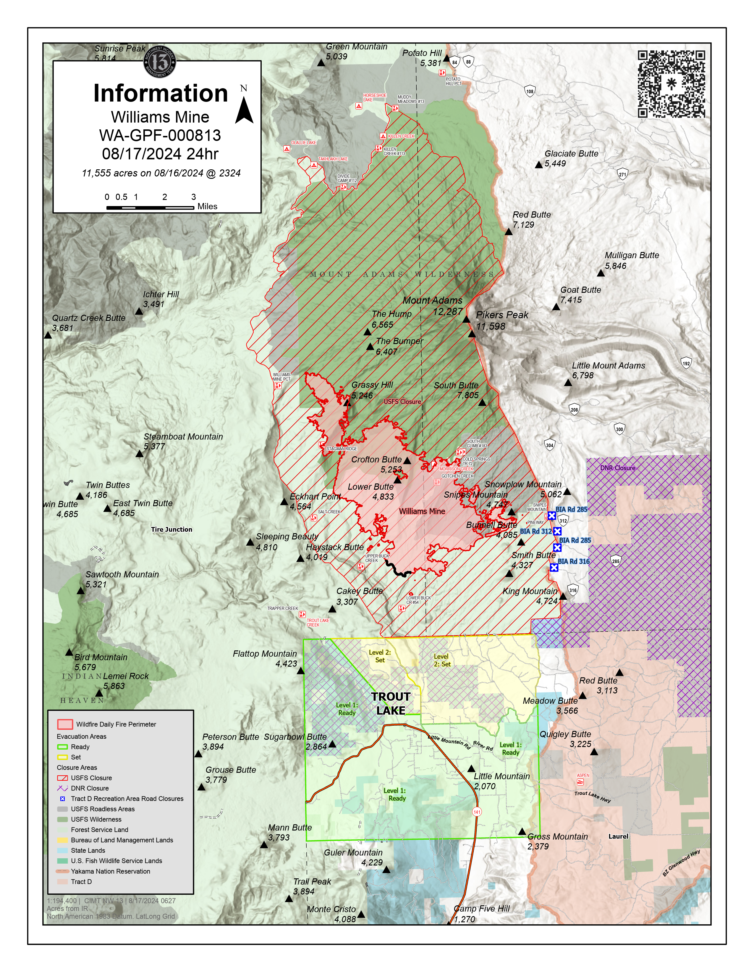
Williams Mine Fire Update 08 17 2024
Related Incident: Williams Mine Fire-GPNF
Publication Type: News
Williams Mine Fire Update for Saturday, August 17, 2024
KEY MESSAGES:
Incident objectives remain to limit impacts to the communities of Trout Lake, Glenwood, community infrastructure and neighboring tribal lands. Additionally, NW-13 fire management officials and local cooperators collaborate to identify strategic operational actions to minimize impacts to public infrastructure in our water, roads, power, communication systems and protect those cultural and historic values within and near the fire perimeter itself.
CURRENT STATUS:
To ensure fire lines have enough depth to achieve perimeter containment with little to no possibility of reignition, firefighters implemented small scale tactical firing operations along the 150 road to bring the fire edge to indirect containment lines. Tactical firing ignites fuels between the head/edge of the fire and a containment line to minimize rapid fire perimeter progression, controlling fire behavior with operational actions. This operation will secure line perimeter from progressing towards Department of Natural Resources and private lands. Night operations were positioned along the control lines to continue the work done by handcrews during dayshift hours.
To minimize fire progression out of the Mt Adams Wilderness, dozers are building a flanking line to keep the fire from progressing out of the wilderness boundary. An anchor point established from the dozers will then be utilized by firefighting resources to reduce the fuel load along the landscape where the fire perimeter will be checked once fire progression nears the constructed fire lines.
WEATHER / FIRE BEHAVIOR:
Today, winds will increase out of the east. There is a strong chance of thunderstorms late in the evening with a chance to produce ¼ to ½ inch of rain. A flash flood watch has been issued for the fire area, though it is unlikely to affect the town of Trout Lake. The high winds could cause the fire to grow, but fuel moisture levels may be high enough to limit fire progression.
SAFETY AND CLOSURES:
A lost mushroom picker was found by a fire safety officer after having spent the night near the fire area. After providing for care, food and water, the lost hiker was transported home safely. Fire managers remind the local community to be mindful when collecting mushrooms and berries by remaining in groups and being well prepared for emergencies while hiking.
Washington DNR managed lands near Trout Lake and Glenwood are closed to entry due to the Williams Mine fire. For more information, please see http://www.dnr.wa.gov/ahtanum. The Confederated Tribes and Bands of the Yakama Nation, Tract D Recreation Area is closed, please see Yakama Tract D Road Closure for more information. Level 1 & 2 evacuations are in effect for the community of Trout Lake, and parts of Klickitat County. Evacuations are coordinated through the Klickitat County Sheriff’s Office and the Skamania County Sheriff’s Office. The FS-23 and FS-25 roads are closed, see the Williams Mine Area and Road Closure for more details. The Pacific Crest Trail (PCT) is closed from the PCT's intersection with FS 23 to Potato Hill. The current area closure spans the entire Mt. Adams Wilderness.
Cottage GroveLane 1 Fire Update 08 17 2024
Related Incident: Lane 1 Fire
Publication Type: News
Shift in weather expected, mop up focus of firefighting activity
COTTAGE GROVE, Ore. – The northern portion of the Cottage Grove – Lane 1 Fire is in patrol status, while all other areas are now in mop up. This transition to mop up will further secure the perimeter, resulting in increases to the fire’s containment. Today, the containment has increased to 42%.
Mop up is the methodical process firefighters use to work in from the perimeter of the fire, locating areas of heat that could rekindle, using tools such as a shovel or a Pulaski and water they can extinguish these hot spots. Areas are gone over multiple times to ensure there is no residual fire. After mopping up, the area is patrolled regularly by firefighters, looking for visible smoke.
Battle Mountain Complex Daily Update 08 17 2024
Related Incident: Battle Mountain Complex
Publication Type: News
Rain provides relief over much of the fire area
Total Complex Estimated Acres: 183,026
Location: Ukiah, Oregon
Cause: Under Investigation
Personnel: 750
Containment: 94%
Estimated Cost: $72 million
Resources: 10 crews | 15 engines | 1 helicopter | 21 water tenders | 13 dozers
Operations: County officials lifted all remaining evacuation statuses associated with the Battle Mountain Complex yesterday. However, firefighters still have objectives remaining including repair of any impacts from the suppression activities. Their goal is still to leave areas fully repaired and follow through with the back-up firelines started during the height of suppression around Penland Lake.
Rain received across the northern half of the fire on Thursday took much of the heat out of the challenging areas of Swale, Ditch, Ellis and Potamus drainages. However, heat may remain in larger fuels that will continue to smolder as conditions dry and the wind increases today. Firefighters will monitor this fire activity and take any actions needed.
Today firefighters and equipment operators will continue the repair work they have been doing over the past several days. Removal and processing of trees will continue around Penland Lake. Winds and dry conditions will cause any new starts to spread rapidly. Crews are ready to respond if needed.
Less firefighters and equipment are required to complete the remaining work. This means the support services they need are also reducing. The Incident Management Team will begin downsizing the fire camps in Long Creek and Ukiah in an orderly fashion. Residents may see increased traffic over the next several days as equipment and trailers are packing up camps.
The public can expect to see increased fire vehicles on the road. Use caution when driving especially on blind curves where lowboy trailers may be traveling.
Weather: Today is expected to be mostly sunny with little chance of rain or thunderstorms. Winds will be from the southwest at five to eight miles per hour. They will increase in the afternoon up to 18 miles per hour. A few clouds may develop on Monday. Highs around 80 to mid-90s.
Smoke: Smoke has moderated but is expected to persist from regional fires in the area. Residents can expect to continue to see smoke from interior pockets of unburned fuel. To see a detailed smoke outlook visit: https://linktr.ee/battlemntcomplex2024
Public Land Closures: Both the Bureau of Land Management and U.S. Forest Service have either rescinded or reduced closure orders for public lands. Visit https://linktr.ee/battlemntcomplex2024 for more information.
Road closures and fire restrictions: https://linktr.ee/battlemntcomplex2024
Grant, Morrow and Umatilla County Evacuations: https://linktr.ee/battlemntcomplex2024
Warner Peak Fire Daily Update August 17 2024 08 17 2024
Related Incident: Warner Peak Fire
Publication Type: News
Warner Peak Fire Update
Daily Update August 17, 2024
Acres: 65,002 Start Date: 08/05/24
Location: Lake County, OR Personnel: 462
Containment: 60%
Highlights: Crews continue to make progress building and strengthening containment lines. Yesterday’s cooler temperatures and higher relative humidity helped moderate fire activity and smoke. Due to predicted hotter, drier conditions over the next few days, with high winds and gusts over 50 mph in some areas, expect to see more active fire and smoke in the area.
Fire Activity: Suppression progress continues, and containment lines are holding well on the east and north portions of the fire. Firefighters have been extinguishing hot spots particularly, in the southwestern and western portions of the fire. Hot spots on the south and southwest portions of the fire that may have been smoldering and undetected in the last couple of days under the moderate weather conditions, will be easier to identify as fire behavior is expected to increase with today’s hotter and drier weather conditions. T
Today’s focus will be to continue direct attack on the western and southern perimeters. Additionally, crews will be watching the eastern portion of the fire closely because, while no hot spots have been detected along the perimeter, the strong gusty winds could carry embers from the interior. Aviation resources may be limited due to the weather forecast for strong gusts.
Closures: The Hart Mountain National Antelope Refuge is closed for public and firefighter safety.
In coordination with the Southwest Area Incident Management Team, the Lake County Sheriff’s Office has issued evacuation orders for the Hart Mountain area in support of firefighting efforts on the Warner Peak Fire. For detailed information visit www.lakecountyor.org.
Weather: A Red Flag Warning has been issued for this afternoon. Sustained winds of 26-30mph and gusts over 50mph are forecast. Humidities will decrease to 11%.
Smoke: Wildfire smoke from the Warner Peak Fire may impact the community of Plush and surrounding areas.Go to www.airnow.govto see the latest smoke conditions in your community.
More Information:
Information Phone Line: 541.208.1770
Email: 2024.warnerpeak@firenet.gov
Facebook: facebook.com/warnerpeakfire
Inciweb: inciweb.wildfire.gov/incident-information/orshr-warner-peak
Black Canyon Fire Daily Update 08 17 2024
Related Incident:
Publication Type: News
Key Message
As mop-op operations continue and containment increases, fire resources will progressively demobilize today through Monday. The current objectives are focused on holding, improving, and securing existing fire line and rehabilitating previously constructed contingency lines.
Current Status
Yesterday, crews focused on securing the fire perimeter through continued mop-up operations. A Type 1 helicopter (Chinook) dropped water on hot spots, while crews worked on holding and improving fire line by utilizing existing hose lays and 25,000 gallons of water. Two skidgines transported water to refill two large portable water tanks, positioned at the base of the old switchback road, allowing fire engines to refill and use the water on the fire. The southern fire is now completely contained, and crews have removed hoses from the area. Heavy equipment was used to rehabilitate previously constructed contingency lines.
Today, engines, heavy equipment operators and hand crews will continue mop-up operations on the northern fire and the 12-acre hot spot in the middle. For the fully contained southern fire, crews will patrol the area to ensure nothing crosses the fire’s perimeter. Firefighters will remove hoses and equipment from the fire line when they are confident in its containment.
Weather and Fire Behavior
Last night, the incident area received 1/4 inch of rain. Fire behavior was moderate, with smoldering of heavy fuels (logs and stumps) in the interior and creeping in the interior islands of unburned fuels. Today, expect quiet and dry weather conditions with a chance of scattered thunderstorms. The weather will be sunny, with temperatures ranging from 78-82 degrees and variable southwest winds up to 10 mph.