
Kachess Complex Fire FINAL Update August 17th 2024 08 17 2024
Related Incident: Kachess Complex
Publication Type: News
Kachess Complex FINAL Fire Update August 17th, 2024
Reported date: August 9th &10th, 2024 Cause: Lightning
Total complex size: ~23 acres Personnel: 155
Fuels: Timber, timber litter, timber understory
Strategy: Full Suppression
Fire behavior: Smoldering, creeping, single tree torching
Location: On the Okanogan-Wenatchee National Forest northwest of Cle Elum. The Stave Creek and Thomas fires are between Kachess and Cle Elum Lake. The Waptus fire is further north in the wilderness near Waptus Lake.
CLE ELUM, Washington: This evening at 6:00 PM, the Albuquerque Zone Type 3 Incident Management Team will transition fire management responsibilities back to the Cle Elum Ranger District. Recent days have seen significant progress towards containment of the complex, and this will be the final report unless notable developments arise. A smaller, type 4 organization will continue to manage the fire in the coming days. For further information, please direct inquiries to the local district.
The Kachess Complex Includes:
- Stave Creek Fire: Approximately 12.5 acres and 35% contained located on steep, rugged, and remote terrain. Firefighters are reinforcing the eastern flank and trying various strategies to safely contain the western flank. Two hotshot crews are on site, focusing on securing accessible areas of the fire line today. Although aerial resources couldn’t operate in the fire area yesterday, they are expected to conduct bucket drops today. All personnel will leave the fire line early this evening due to expected thunderstorms in the area.
- Thomas Fire: Currently 9 acres and 95% contained. A recon flight is scheduled today to monitor for any remaining smoke.
- Waptus: Currently one half acre and 100% contained. All fire personnel were extracted via helicopter on August 14th, 2024.
A message from the Albuquerque Zone Incident Commander, Lino Baca: “We would like to thank the community, local district, and cooperators for your kindness and support during our time on the incident. Safety has been our biggest priority, and significant measures were taken to ensure fire line tactics mitigated risk to the greatest extent. It is always a pleasure working with various area resources and we look forward to working with the Okanogan-Wenatchee fire staff again."
Weather: Showers and thunderstorms are predicted for Saturday afternoon into Sunday morning in the fire area. A flood watch will be in effect Saturday evening for areas within a wildfire burn scar. Marine layers settling over the fire may inhibit aerial operations today.
Safety: The health and safety of firefighters and the public are always the top priority. Members of the public should avoid the Kachess Complex area. A new TFR (temporary flight restriction) is in effect around the fire otherwise noted. Unmanned aircraft such as drones pose a serious risk to firefighting and can cause air operations to cease. The public is reminded that “If you fly, we can’t!”.
Temporary flight restriction: https://tfr.faa.gov/tfr2/list.jsp
Closures: There are no closures in place for the Kachess Complex, however, the public is encouraged to avoid the surrounding trails of the Stave Creek and Thomas Fires. Fire restrictions are in effect on the Cle Elum Ranger District, for additional information visit: https://www.fs.usda.gov/detail/okawen/alerts-notices/?cid=fsbdev3_053600 .
Incident Information
Cracker Jack Complex Update 08 17 2024
Related Incident:
Publication Type: News
Cracker Jack Complex
Nez Perce-Clearwater National Forests
Fire Information 208-935-6134
https://inciweb.wildfire.gov/idncf-cracker-jack-complex
August 17, 2024
NCF Type 3 Incident Management Team
TC Peterson, Incident Commander
Kane Steinbruecker, Incident Commander Trainee
Location: All four fires are located within half a mile of each other: two and a half miles east of Concord, ID, less than one tenth of a mile east from Square Lake and less than a quarter mile southwest from Fish Lake.
Start Date: Square Lake Fire-8/10/2024
Whistling Pig Fire- 8/10/2024
Fish Fire- 8/10/2024
Fish 2 Fire- 8/11/2024
Cause: Lightning
Size: 265 acres *increase to do more accurate mapping
Completion/Containment: 0%
Total Personnel: 65
8 Masticators
2 Feller Bunchers
1 Suppression Module
Key Message:
All four fires are burning in the Gospel-Hump Wilderness. Management actions are limited, based off the steep terrain of the Gospel-Hump Wilderness and the threat of snags in the area from previous large fire scars that surround the Cracker Jack Complex.
Current Status:
On August 10, 2024, a small lightning storm passed through portions of the Red River Ranger District, starting the Square Lake Fire, Whistling Pig Fire, Fish Fire, and the Fish 2 Fire. All four fires are located within half a mile of each other: two and a half miles east of Concord, ID, less than one tenth of a mile east from Square Lake and less than a quarter mile west from Fish Lake.
Firefighters continue structure protection around the Concord-Calendar, Humptown, and Frogtown areas. Firefighters continue prepping the National Forest Service Road #311 to hold the fire from moving east towards values at risk. Fire activity and behavior remain minimal at this time; however, conditions could change as weather becomes warmer and drier.
Weather and Fire Behavior
A high-pressure system will build over the region today, resulting in warmer and drier conditions. Tonight, chances for monsoonal moisture increase, with potential for scattered showers and thunderstorms increases later in the day on Sunday, August 18. From today through Monday, August 19, temperatures will range between mid-90s to low 100s.
Closures and Special Messages
At this time there are no closures, but if fire activity increases more, closures will likely take place.
The public is highly encouraged to avoid the National Forest Service Road #311, due to firefighter resource and heavy equipment traffic going in and out of the area.
Miners Complex Daily Update 08 17 2024
Related Incident: Miners Complex Fires
Publication Type: Announcement
11:00 AM, August 17, 2024
Estimated size: 1,098 acres
Start Date/Time: July 17, 2024
Area of Origin: 21 air miles east of Darrington WA
Cause: Lightning
Fuels/Topography: timber, rugged terrain
Structures Damaged: None, there are no homes threatened at this time.
Evacuations: None
The Miners Complex consists of ten wildfires caused by lightning strikes in the Mt. Baker-Snoqualmie National Forest. The fires included in the complex are: Miners Fire, Vista Ridge Fire, Dolly Creek Fire, Sulphur Three Fire, Sulphur Four Fire, Sulphur Thirty-Four Fire, Upper Sulphur Thirty-Two Fire, Lower Sulphur Thirty-Two Fire, Plummer, and Middle Ridge Fire.
Update: Minimal fire behavior has continued with slightly warmer temperatures due to high relative humidities, good overnight recoveries, and cloud cover. Despite the cooler weather, the fire remains active and firefighters have patrolled the area over the last few days. With today’s forecasted warm weather and expected thunderstorms, firefighters continue to patrol and monitor fire behavior.
Weather: Conditions Saturday will be warm and dry with increasing instability in the afternoon. Widespread thunderstorms are expected this late evening with a disturbance, moving south to north near the fire. The storms may produce gusty and erratic winds, and bursts of heavy rain Saturday night into Sunday morning. While storms are expected to move quickly, any redeveloping storms may increase the threat for flash flooding. The threat for thunderstorms Sunday will decrease during the day as the disturbance departs. Mostly sunny and max temperatures around 82. East winds around 5mph.
Smoke: For more information on smoke and air quality please visit: https://wasmoke.blogspot.com/
Closures: The following is a summary of the areas closed due to the fires in the Miners Complex. Pacific Crest National Scenic Trail #2000.2 from Mica Lake to Suiattle Pass, Suiattle River Trail #784, Miners Ridge Trail #785, Buck Creek Pass Trail #789, Miners Cabin Trail #795, Grassy Point Trail #788, Sulphur Mountain Trail #794, Sulphur Creek Trail #793, Sulphur Creek Campground, Sulphur Creek Trailhead, and the Downey Creek trailhead. The full Closure Orders visit: https://www.fs.usda.gov/mbs
Forest Restrictions: The Mt. Baker-Snoqualmie has a full campfire ban and forest-wide shooting restrictions in place to help prevent human-caused starts during this period of unprecedented resource scarcity. Additional details at: www.fs.usda.gov/mbs
###
Pincer Two Fire Daily Update 08 17 2024
Related Incident: Pincer Two Fire
Publication Type: Announcement
11:00 AM, August 17, 2024
Estimated size: 189 acres
Start Date/Time: July 17, 2024
Area of Origin: Johannesburg Mountain. 1 Mile East of Mineral Park C.G.
Cause: Lightning
Fuels/Topography: Timber, rugged terrain
Structures Damaged: None, there are no homes threatened at this time.
Evacuations: None
Closures: Cascade River Road at and including Marble Creek Campground, Mineral Park Campground, and all tributary roads, trailheads, and trails are all closed. The public is not to enter the area for public and firefighter safety.
Full closure orders available at: https://www.fs.usda.gov/mbs
Update: Minimal fire behavior has continued with slightly warmer temperatures due to high relative humidities, good overnight recoveries, and cloud cover. Despite the cooler weather, the fire remains active and firefighters have patrolled the area over the last few days. The fire continues to hold above the Cascade River Road. With today’s forecasted warm weather and expected thunderstorms, firefighters continue to patrol and monitor fire behavior.
Weather: Conditions Saturday will be warm and dry with increasing instability in the afternoon. Widespread thunderstorms are expected this late evening with a disturbance, moving south to north near the fire. The storms may produce gusty and erratic winds, and bursts of heavy rain Saturday night into Sunday morning. While storms are expected to move quickly, any redeveloping storms may increase the threat for flash flooding. The threat for thunderstorms Sunday will decrease during the day as the disturbance departs. Mostly sunny and max temperatures around 82. East winds around 5mph.
Smoke: For more information on smoke and air quality please visit: https://wasmoke.blogspot.com/
Air Space Restrictions: There are no air space restrictions at this time.
Forest Restrictions: The Mt. Baker-Snoqualmie has a full campfire ban and forest-wide shooting restrictions in place to help prevent human-caused starts during this period of unprecedented resource scarcity. Additional details at: www.fs.usda.gov/mbs
###
Actualizacin diaria del incendio Easy 17 de agosto de 2024 08 17 2024
Related Incident: Easy Fire
Publication Type: News
Actualización diaria del incendio Easy
17 de agosto de 2024
Datos clave
Tamaño: 2,130 acres
Fecha de inicio: 17 de julio de 2024
Ubicación: 17 millas al oeste de Mazama, WA
Contención: 29%
Personal asignado: 309
Causa: Rayo
Recursos asignados: 10 equipos de obreros, 13 camiones de bomberos, 6 tanques de agua
SITUACIÓN ACTUAL: Las tormentas eléctricas resultaron en lluvias y rayos sobre la zona del incendio ayer. Los bomberos están aprovechando la intensidad menor del fuego, al construir un cortafuegos lo más cerca posible del extremo sur del incendio. El cambio a un clima inestable y tormentas eléctricas sobre el área del incendio por la tarde crearon condiciones peligrosas para los bomberos. El trabajo de extinción se detuvo temporalmente debido al mayor riesgo de flujos de escombros, caída de árboles y otros peligros relacionados con las fuertes lluvias y vientos. El clima también afectó la capacidad de los recursos aéreos para trabajar por la tarde.
ACTIVIDADES DE HOY: Se espera que hoy continúe la intensidad moderada del fuego. Los bomberos comenzarán de nuevo el trabajo de extinción a mientras que las condiciones climáticas lo permitan. A lo largo del extremo sur del incendio, las cuadrillas continuarán fortaleciendo un cortafuegos desde la carretera 20 hacia Swamp Creek para evitar que el fuego se propague hacia el este y el sur. También siguen vigilando el corredor de la carretera 20, al extinguir cualquier foco de calor. A lo largo del extremo norte, usarán un dron o un sistema de aeronave no tripulada (UAS) con tecnología infrarroja para detectar cualquier calor de fuego y extinguirán focos de calor cuando sea posible.
CLIMA y HUMO: El día de oy será mayormente soleado y seco y habrá vientos moderados que soplarán del suroeste todo el día. Existe la posibilidad de tormentas eléctricas al atardecer el día. El domingo estará mayormente nublado con un 70% de probabilidad de lluvia y la posibilidd de más tormentas eléctricas. El pronóstico del humo para los incendios Pioneer e Easy Fires está disponible en https://outlooks.airfire.org/outlook/es/f79a6d6d.
CIERRES: La carretera 20 está cerrada en ambas direcciones entre Granite Creek (MP 148) y Rainy Pass (MP 157): https://wsdot.com/Travel/Real-time/Map/. Manténgase al día en.
El Bosque Nacional Okanogan-Wenatchee tiene cierres vigentes para los senderos dentro del área del incendio. Para saber más vaya a Okanogan-Wenatchee National Forest - Alerts & Closures (usda.gov). Este cierre incluye una parte del sendero Pacific Crest Trail. Están prohibidas las fogatas.
Hay una restricción temporal de vuelo (TFR, en inglés) sobre el área del incendio: https://tfr.faa.gov/save_pages/detail_4_6779.html. La actividad de drones no autorizados está prohibida por la TFR.
EVACUACIONES: No existen órdenes de evacuación para el incendio Easy. Cualquiera que utilice la zona para recrearse debe estar atento a su entorno y permanecer fuera de las áreas cerradas.
InciWeb: https://inciweb.wildfire.gov/incident-information/waowf-easy-fire
Facebook: https://www.facebook.com/profile.php?id=61560760893080
Línea de información sobre el incendio: 541-861-5808, 8 AM to 8 PM
Correo electrónico: 2024.easy@firenet.gov
Actualizacin diaria del incendio Pioneer 17 de agosto de 2024 08 17 2024
Related Incident:
Publication Type: News
Actualización diaria del incendio Pioneer
17 de agosto de 2024
Tamaño: 38,728 acres
Fecha de inicio: 8 de junio de 2024
Ubicación: 31 millas al NO de Chelan, WA
Contención: 23%
Personal: 668
Causa: A ser determinada
Recursos asignados: 7 equipos de obreros, 6 helicópteros, 21 camiones de bomberos, 26 tanques de agua, 13 maquinarias pesadas
SITUACIÓN ACTUAL: Los bomberos construyeron con éxito una línea de mano directa entre los desagues de Boulder Creek y Little Boulder Creek y esta se une a la línea de retardante en la cresta. Las aeronaves en el área alrededor de Stehekin pudieron verter retardante varias veces antes de que las tormentas eléctricas obligaran tanto a estas operaciones como a las cuadrillas de tierra a pausar. Las lluvias fuertes y las ráfagas de viento causadas por estas tormentas crean condiciones de trabajo peligrosas mediante escombros rodantes, árboles caídos y el riesgo de deslizamientos de tierra. Por la noche, los bomberos patrullaron el área de Stehekin para ver la intensidad del fuego y asegurar que las medidas que se tomaron para proteger estructuras permanezcan en su lugar. Se ha contenido el fuego a lo largo de la orilla del lago. Los bomberos continúan patrullando y protegiendo cabañas, muelles y otras infraestructuras a través del lago. El extremo sur del incendio sigue con pocas muestras de calor y hasta ninguno y las cuadrillas siguen vigilando el área para detectar cualquier posible actividad de fuego. Al sur del incendio y al este de Manson, los bomberos trabajaron para proteger las estructuras cerca de Deer Point y removieron la maleza y los escombros creados por el trabajo que se realizó anteriormente en la línea de contingencia.
ACTIVIDADES DE HOY: Tanto dentro como alrededor de la comunidad de Stehekin, las cuadrillas patrullarán la línea de mano en Little Boulder Creek cerca del perímetro del incendio para minimizar cualquier calor cerca de la línea. Los helicópteros comenzarán de nuevo a verter agua y retardante de manera estratégica donde sea necesario para enfriar los focos de calor y ayudar a los bomberos en tierra. Los bomberos revisarán las millas de mangueras y rociadores alrededor de la comunidad para asegurarse de que todo funcione bien. Cerca de la pista de aterrizaje, también se sigue preparando la línea de contingencia. Las cuadrillas que patrullan el extremo sur estarán preparadas y disponibles para responder a cualquier necesidad de ataque inicial en el área alrededor si llega a haber nuevos fuegos debido a rayos recientes. Los preparativos de la línea de contingencia, que incluyen el trabajo de líneas divisorias de combustible al sur del incendio y al este de Manson, están finalizando y las cuadrillas han terminado de cortar vegetación y están trabajando para completar la remoción de maleza y escombros restantes.
CLIMA y HUMO: El día de hoy será cálido, con temperaturas en los 80 grados. La posibilidad de tormentas eléctricas que ocurran por la noche y hasta las primeras horas de la mañana del domingo es alta. Se prevé que el sistema meteorológico pronosticado resultará en ráfagas de viento, lluvias intensas y rayos aislados a dispersos por toda la zona del incendio.
El pronóstico del humo para los incendios Pioneer e Easy Fires está disponible en https://outlooks.airfire.org/outlook/es/f79a6d6d.
EVACUACIONES: Los niveles 1, 2 y 3 de evacuación siguen vigentes alrededor del incendio Pioneer. Comuníquese con el Departamento de gestión de emergencias del condado de Chelan o visite https://t.ly/QoH9w para obtener más información.
CIERRE DEL BOSQUE: Cierres vigentes del Parque nacional North Cascades: https://www.nps.gov/noca/index.htm
El Bosque Nacional Okanogan-Wenatchee ha emitido una orden de cierre sobre gran parte del área afectada por el incendio: Okanogan-Wenatchee National Forest - Alerts & Closures (usda.gov). Las fogatas están prohibidas. Hay una restricción temporal de vuelo (TFR, en inglés) sobre el área del incendio: https://tfr.faa.gov/save_pages/detail_4_6779.html. La actividad de drones no autorizados está prohibida por la TFR.
InciWeb: https://inciweb.wildfire.gov/incident-information/wases-pioneer
Facebook: https://www.facebook.com/profile.php?id=61560760893080
Línea de información sobre el incendio: 541-861-5808, de 8 AM a 8 PM
Correo electrónico: 2024.pioneer@firenet.gov
Cougar Creek Fire Update 8172024 08 17 2024
Related Incident: Cougar Creek Fire
Publication Type: News
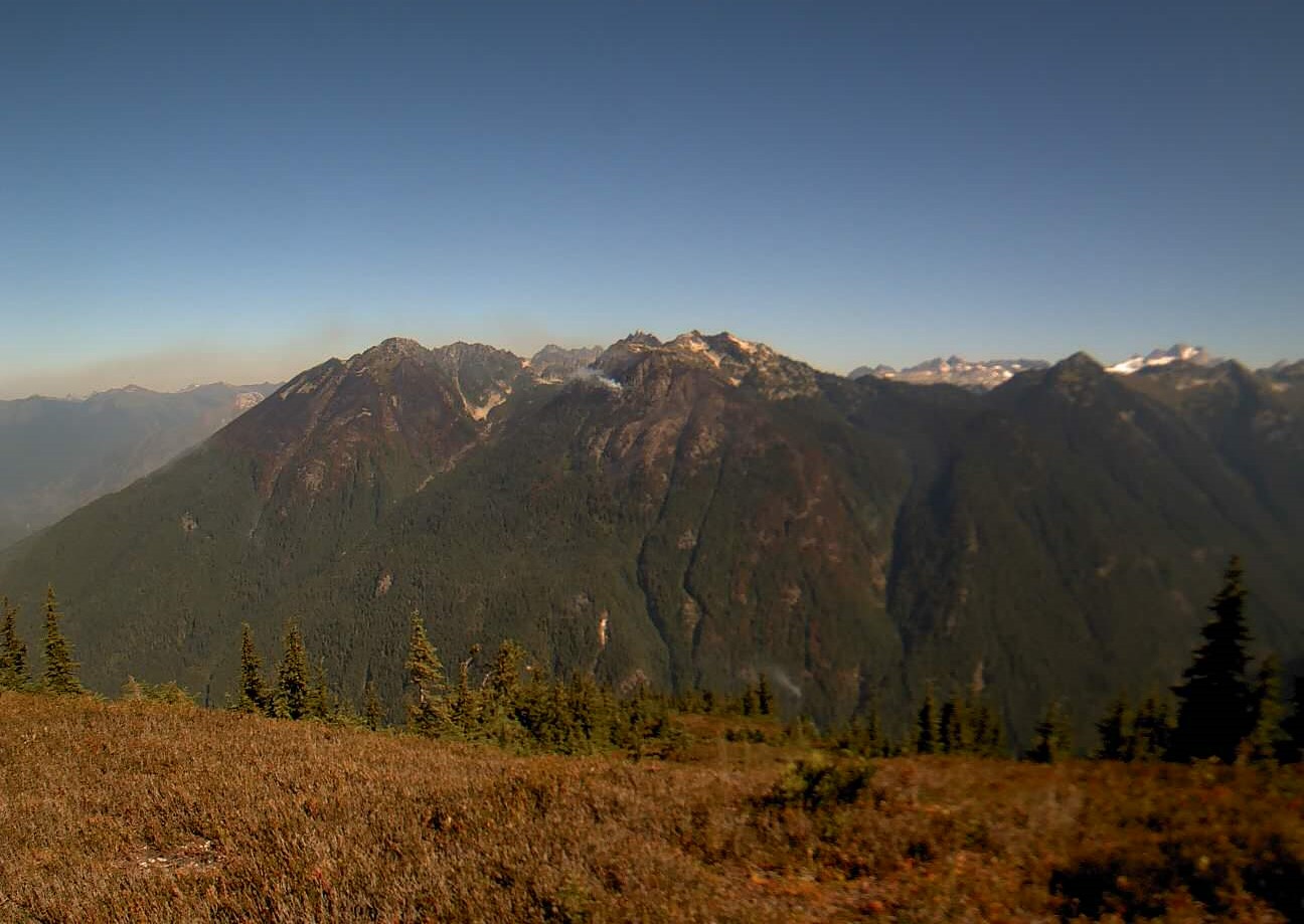
The Cougar Creek Fire is burning within a mountainous and remote area on the Umatilla National Forest bordering the Wenaha-Tucannon Wilderness.
Yesterday, mop-up operations made great progress along the north and western edge of the containment lines, increasing containment by 10 percent. The Falling Module continued to remove hazardous trees and snags, successfully ensuring firefighter safety and smooth operations. Firefighters continued to patrol containment lines looking for areas of concern. Fire crews to the south continued to repair work along dozer and handlines, suppression repair work included cleanup and erosion mitigation.
Yesterday an IR flight was completed, and all hotspots were located within the interior of the fire perimeter. Only a few hotspots were located near the interior of the the primary containment lines.
Today, operations will continue to focus on mop-up operations along the northwest and west portions of the fire’s edge from CCC camp to Saddle Butte. Firefighters will continue to patrol the containment lines and address hotspots identified with the IR flight. Crews to the south and eastern portions of the fire will continue with suppression repair work focusing on Dozer and handlines. Fire crews will continue to backhaul equipment and hoses in areas they are no longer required. The interior will continue to produce smoke as left over fuel is consumed and may be visible to the public.
Evacuations and Closures: All evacuation orders have been lifted. Forest closure descriptions and maps are available online on the Umatilla National Forest closure website. Please respect area closure orders and use extra caution while driving for your safety as well as our firefighters.
Weather and Smoke: High 83/Low 53: Saturday winds will begin to increase and shift east at 5 to 8 mph with gusts to 17 likely. Daytime RHs will be poor/moderate ranging 22-27% with moderate overnight recoveries. Winds will continue to be a bit breezy overnight Saturday with winds from the east-northeast 5 to 10 mph with gusts to 20 mph then shifting to the southwest at 6 to 9 mph with gusts to 22 mph around 11 PM. Sunday winds will start from the southwest at 5 to 7 mph before shifting to the northeast around 5 PM. Daytime Rhs Sunday will moderate ranging between 30-40%
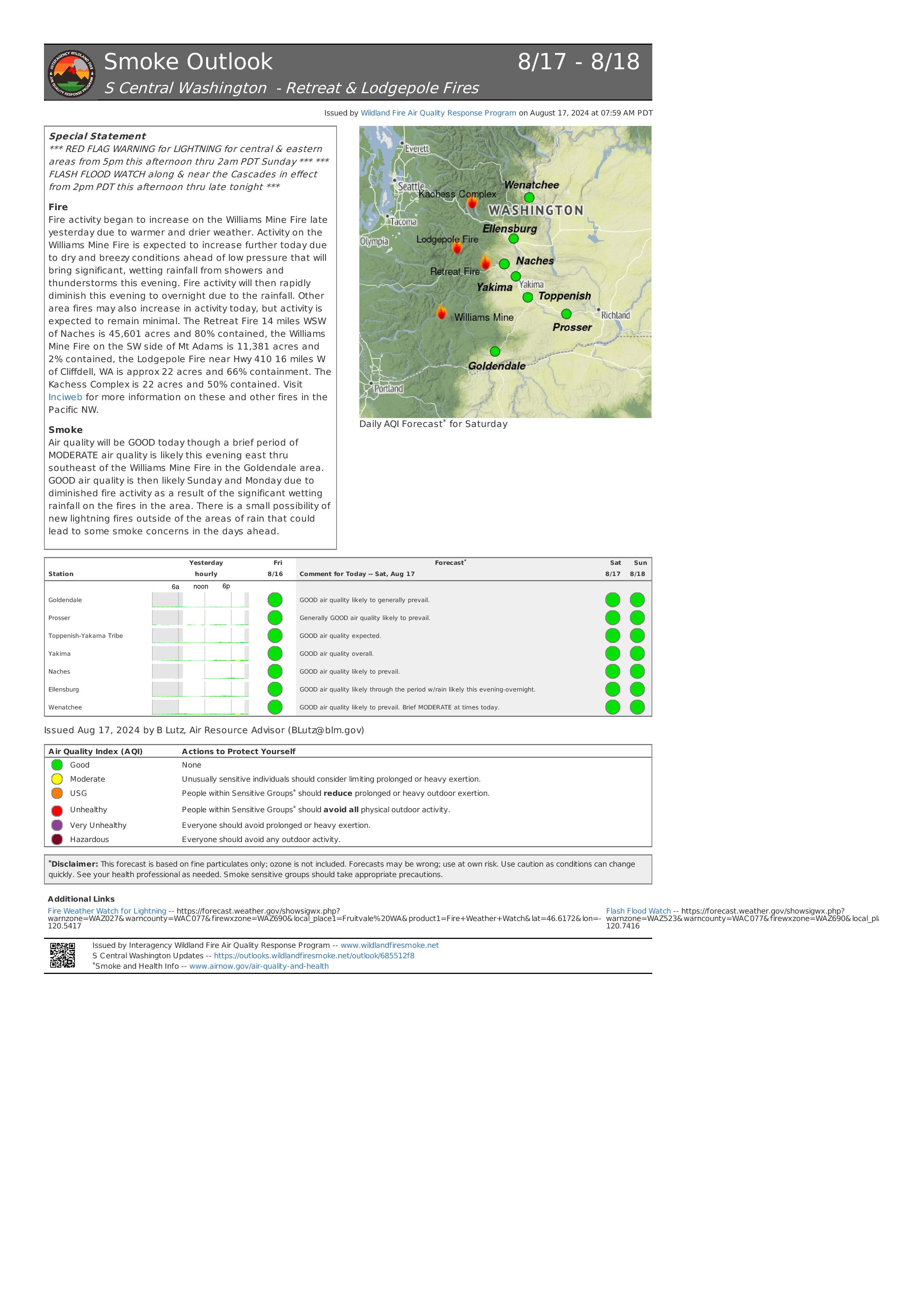
Retreat Fire Morning Update August 17 2024 08 17 2024
Related Incident: Retreat
Publication Type: News
Retreat Fire Morning Update - August 17, 2024
Phone: 509-213-4890, 8 a.m. to 8 p.m.
Email: 2024.Retreat@firenet.gov
Fire Information: linktr.ee/CIIMT14
Total Acres: 45,601 acres Containment: 80% Total Personnel: 339
Current Situation: The Washington State Department of Transportation reopened US 12 at 8 a.m. today. Travelers should plan for added travel time due to single-lane, alternating one-way traffic as WSDOT and emergency contractor crews work to replace guardrail and highway signs along US 12 between mileposts 185, near the junction with State Route 410 and milepost 168, near the Tieton Road intersection. The public is reminded that multiple fire closures for the area are still in place (see Fire Closures below).
Today, firefighters will patrol containment lines, extinguish any hot spots they find, fall hazard trees along internal road systems to provide for safer access across the fire, remove materials (logs and brush) left from preparing the shaded fuel break along Forest Roads 1200 and 1201, and remove unneeded equipment and fire hose from the fireline.
The control objective for the Retreat Fire is to keep the fire contained within the natural and constructed control features while prioritizing public and firefighter safety.
Weather: There is a flash flood watch for burn areas this afternoon. Thunderstorms are expected over the fire area from 5 p.m. to 2 a.m., with potential of ½ to 1” of precipitation within the storm track. Wind gusts could be up to 50 mph near thunderstorms. Elsewhere there is a slight chance of showers. Minimum humidity is expected decrease (21-27%) and the high temperature is expected to increase to the low 80’s over the fire area compared to yesterday.
Evacuations: Yakima County Emergency Management lifted all evacuation orders for the Retreat Fire as of 8:00 a.m. on Friday August 16. Residents should inspect their surroundings with caution and be aware that fire damaged trees, power poles, and other structures may have been weakened by the fire.
Fire Closures:
- Okanogan-Wenatchee National Forest Retreat Fire Closure (tinyurl.com/5ext5aec).
- The Washington State Department of Natural Resources (DNR) Southeast Region has temporarily closed part of the Ahtanum State Forest. The public can access the most up-to-date closure information at dnr.wa.gov/ahtanum.
- Washington Department of Fish and Wildlife has closed the majority of the Oak Creek Wildlife Area to public access due to the Retreat Fire until August 23, 2024. More information can be found at tinyurl.com/bdet7845.
Air Quality and Smoke: Air quality and smoke condition outlooks can be found at airnow.gov.
Lodgepole Fire Daily Update August 17 2024 08 17 2024
Related Incident: Lodgepole
Publication Type: News
Lodgepole Fire Daily Update - August 17, 2024
Acres: 35
Containment: 6%
Total Personnel: 47
Phone: 509-213-4890, 8 a.m. to 8 p.m.
Email: 2024.Lodgepole@firenet.gov
Fire Information: linktr.ee/CIIMT14
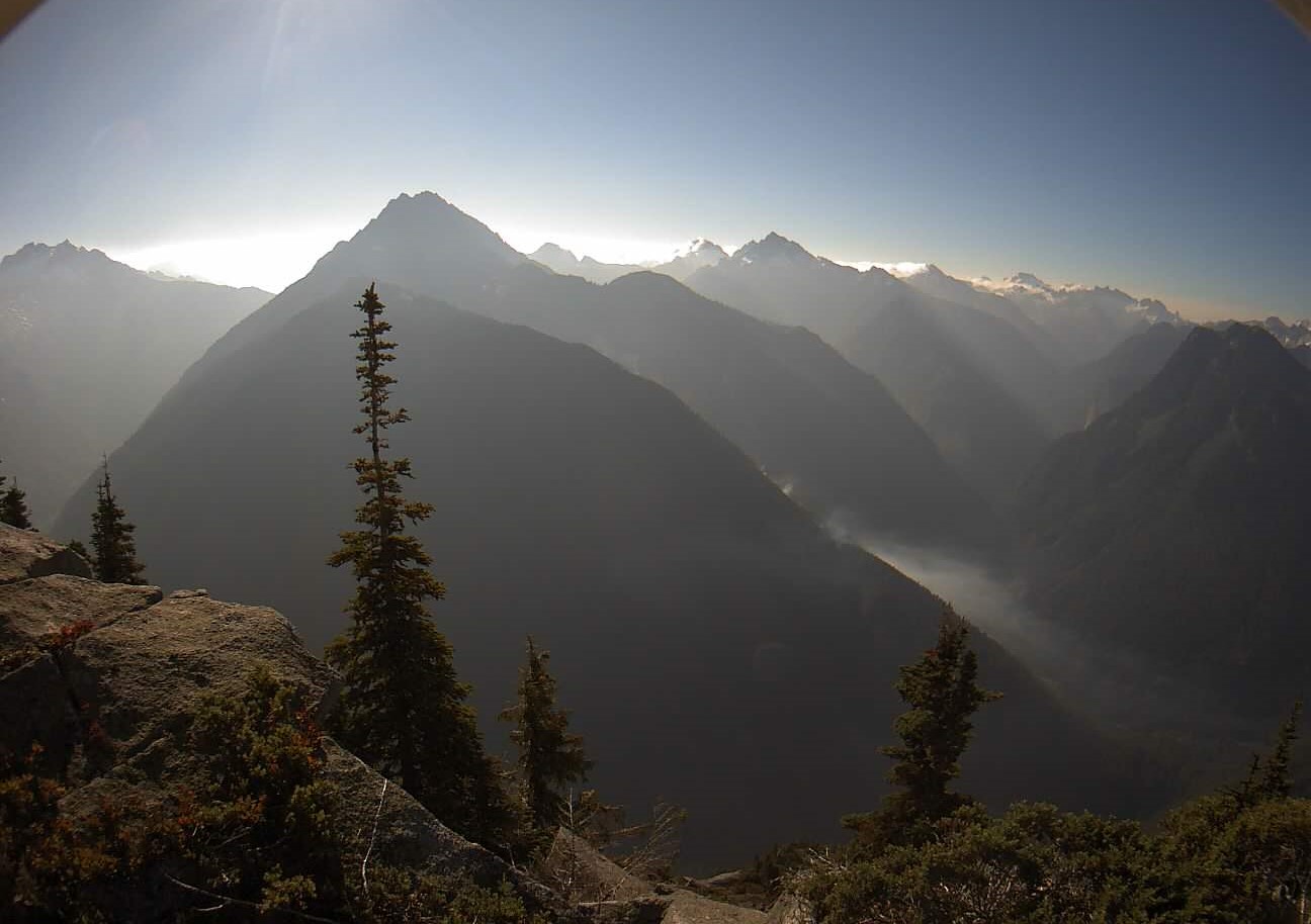
Current Situation: The Lodgepole Fire is located in the Norse Peak Wilderness, north of Highway 410 near the Lodgepole Campground, located within the Okanogan-Wenatchee National Forest.
Firefighters and dozers have been constructed a control line between the fire and Highway 410. Crews installed hoses and sprinklers along this control feature to ensure the fire does not move further south toward Highway 410. Protecting the highway corridor and preventing the Lodgepole Fire’s southern spread remains a top priority for the incident.
Helicopters continued to work throughout the day Friday, dropping water onto the larger hot spots to slow the fire’s growth and progression. The fire’s northern spread uphill has slowed due to the fuel model changing and getting hung up in rocky terrain. The fire remains mostly creeping and smoldering with a majority of the heat being produced by the consumption of large down debris as a result of burning within the footprint of the 2017 Norse Fire.
Due to the Lodgepole Fire’s location in the steep and rugged wilderness as well as the enormity of large dead standing trees throughout the previous burn area, firefighters are having to be strategic on where they can safely construct control lines. Firefighters are planning to use natural holding features that would assist them in containing the fire to the east and west.
The fire remains a threat to multiple privately owned cabins in nearby Forest Service recreational residence cabin tracts both to the east and south of the fire. Over the past several days, firefighters have cleared vegetation around these cabins and installed sprinkler systems should the fire move closer to these structures.
Weather: There is a flash flood watch for burn areas this afternoon. Thunderstorms are expected over the fire area from 5 p.m. to 2 a.m., with potential of ½ to 1” of precipitation within the storm track. Wind gusts could be up to 50 mph near thunderstorms. Elsewhere there is a slight chance of showers. Minimum humidity is expected decrease (21-27%) and the high temperature is expected to increase to the low 80’s over the fire area compared to yesterday.
Closures: The Lodgepole Campground is currently Closed, but there are no other forest or campground closures due to the Lodgepole Fire.
Highway 410 remains open for travel. Please use caution in the area due to smoke impacts as well as firefighters and emergency equipment working along the highway. Travelers are encouraged to check the highway status through Washington State Department of Transportation website at tinyurl.com/4ptbkfua.
Air Quality and Smoke: Air quality and smoke condition outlooks can be found at airnow.gov.
