
Park Fire Morning Update for August 18 08 18 2024
Related Incident: Park Fire
Publication Type: News
Park Fire Morning Update for August 18 is posted on the Park Fire Status Update Page
Pioneer Fire Update 08 18 2024
Related Incident:
Publication Type: News
Pioneer Fire Daily Update
August 18, 2024
Quick Facts
Size: 38,727 acres (no updated IR)
Start Date: June 8, 2024
Location: 31 miles NW of Chelan, WA
Containment: 23%
Personnel: 679
Cause: Under investigation
Resources Assigned: 7 crews, 6 helicopters, 21 engines, 25 water tenders, 11 heavy equipment
CURRENT SITUATION: The Pioneer Fire continues to hold in the Boulder Creek drainage below established retardant lines. Aviation activity increased throughout the day as air attack and reconnaissance flights were flown and air resources dropped retardant and water buckets on areas of heat. Crews checked the miles of hose strategically laid throughout Stehekin. Construction continued on the contingency line to the west of the airport and along the Stehekin hydropower plant. Much of the lakeshore is in patrol status with no immediate threats from the fire at this time. Mastication of larger debris generated from the construction of the contingency line and brushing of roads continued on the south end of the fire near Mason. Resources assisted local agency personnel with initial attack of a new start.
TODAY’S ACTIVITIES: Actions to protect the community of Stehekin and prevent spread of the fire out of the Boulder Creek drainage will continue today. Firefighters will continue to hold and improve the handline tying into the retardant check line and aerial firefighting efforts will focus on cooling hot spots with bucket drops of water. Firefighters will also be patrolling in and around structures in the community and will assess any hazards such as rolling burning logs or downed powerlines that may have occurred after thunderstorms passed through the area Saturday night. East of Manson, resources continue to clean up remaining brush and vegetation following construction of contingency lines. Crews patrolling the south side of the fire will be poised and available to respond to any initial attack needs in the surrounding area if new fires result from recent lightning.
WEATHER and SMOKE: Thunderstorms occurred overnight and continued into the early hours of the morning. Today will be warm, with temperatures in the high 70s or low 80s. This afternoon will bring clouds with a 20% chance of showers or thunderstorms. Winds will be light and down lake throughout the day.
A smoke outlook for the Pioneer and Easy Fires is available at https://outlooks.airfire.org/outlook/f79a6d6d.
EVACUATIONS: The Stehekin area remains under evacuation orders and is not open to public entry. For more information about the evacuation orders in effect around the Pioneer Fire, please visit: https://www.co.chelan.wa.us/emergency-management/pages/active-emergencies
CLOSURES: Current closures for the North Cascades National Park: https://www.nps.gov/noca/index.htm
The Okanogan-Wenatchee National Forest has a closure order in place for much of the fire area: Okanogan-Wenatchee National Forest - Alerts & Closures (usda.gov). Campfires are prohibited. There is a Temporary Flight Restriction (TFR) in place over the fire: https://tfr.faa.gov/save_pages/detail_4_6779.html. Unauthorized drone activity is prohibited under the TFR.
InciWeb: https://inciweb.wildfire.gov/incident-information/wases-pioneer
Facebook: https://www.facebook.com/profile.php?id=61560760893080
Fire Information Line: 541-861-5808, 8 a.m. to 8 p.m.
Email: 2024.pioneer@firenet.gov
Dixon Fire Morning Update 8182024 08 18 2024
Related Incident: Dixon Fire
Publication Type: News
Soaking Rains Aid Crews to Cool Dixon Fire
DAYS CREEK, Ore. – Yesterday’s thunderstorms provided opportunities for improved suppression efforts overnight on the Dixon Fire. Crews traveled with caution on soggy, slippery roads after sheets of rain drenched the area. Oregon Department of Forestry crews identified two fire starts adjacent to the Dixon Fire, and Douglas Forest Protective Association and Umpqua National Forest crews responded. About four-tenths of an inch of rain fell overnight, and containment increased from 23% to 34% yesterday.
Overnight, using hand-held thermal imaging infrared cameras, crews gridded through mop-up areas and further identified spots to be worked.
Today’s crews will work to eliminate those spots and are prepared for quick response to any new ignitions. They will continue to mop up areas up to 200 feet into the boundaries of the fire, following mop up standards for local agencies.
Aerial reconnaissance flights to aid ground resources and look for new lightning fires will resume midday as visibility allows.
Some fire personnel and equipment are beginning to demobilize and return to their home units, providing them opportunity for much needed rest and making them available for future response.
With reduced fire activity, diminished public interest, and increased containment, some information boards will be removed today. Information boards will remain posted in the Tiller area to serve residents who may not have phone or internet access. Information boards will be removed in Canyonville.
Yesterday the Douglas Forest Protective Association announced a decrease in Public Use Restrictions to MODERATE and a decrease to LEVEL 2 for Industrial Fire Protection Levels. Restrictions on open burning remain in effect.
Evacuation levels, managed by the Douglas County Sheriff, were downgraded yesterday afternoon. Please stay up to date on evacuation levels at: http://www.dcso.com/evacuations
Fire Prevention: Know Before You Go - It Only Takes One Spark. Public and industrial restrictions are in place to help prevent wildfires:
• Umpqua National Forest: https://www.fs.usda.gov/main/umpqua/fire
• Oregon Department of Forestry: https://www.oregon.gov/odf/fire/pages/restrictions.aspx
• Douglas Forest Protective Association: https://www.dfpa.net/public-fire-restrictions
Road Update: The Tiller Trail Highway is open; however, with severe weather in the area yesterday, check conditions before you travel. Use Tripcheck to plan ahead: https://tripcheck.com/
Forest Closures: There are two forest closures impacting every district of the Umpqua National Forest. Closure information: https://www.fs.usda.gov/alerts/umpqua/alerts-notices
Smoke Outlook: https://fire.airnow.gov/#
Infrastructure Update: Power has been restored to area residents by Pacific Power. For questions, please contact the Pacific Power Customer Service team at 1-888-221-7070.
Diamond Complex and Middle Fork Daily Update 08 18 2024
Related Incident: Middle Fork Fire
Publication Type: News
The Diamond Complex on the Umpqua National Forest consists of 28 lightning-caused fires totaling approximately 10,843 acres, with 833 personnel assigned. Nineteen of the 28 fires in the Diamond Complex are now 100 percent contained.
The Middle Fork Fire in the northwest corner of Crater Lake National Park is 5197 acres and is 0% contained. Sixty personnel are assigned, and the Diamond Complex is sharing resources as needed. The park remains open.
California Interagecy Incident Management Team 4 assumed command of the Diamond Complex and Middle Fork Fire this morning at 6:00 a.m., and Northern Rockies Complex Incident Management Team 3 is returning home.
KEY MESSAGE:
For public and firefighter safety, the North Entrance Road in the park is temporarily closed for firefighters to prepare control lines with machinery along that road. For details, visit https://www.nps.gov/crla/learn/news/crater-lake-temporarily-closes-north-entrance-for-the-middle-fork-fire.htm
OPERATIONS:
Middle Fork Fire (5,197 acres, 0% contained):
Today, crews will continue clearing vegetation along the 230 Road and at the North Entrance to Crater Lake National Park. On the southern side, crews will continue to look for areas of opportunity to limit spread to the south where safe to do so.
Diamond Complex Fires
Pine Bench Fire (North of Hwy 138 near Dry Creek, 3,864 acres, 31% contained):
Today’s priority will be to contain the movement into Medicine Creek and re-enforce the Sly Creek area. Crews will also be improving the road system by removing vegetation from the west side, moving north.
Potter Fire (North of Hwy 138, two miles southeast of Potter Mountain, 3,243 acres, 5% contained):
On the north side, crews will continue clearing vegetation along the 265 Road, and prep the roads to the east and to the west. On the south side crews will continue looking for opportunities for containment to protect infrastructure.
Trep Fire (About four miles south of Hwy 138, 538 acres, 0% contained):
Crews will continue to improve conditions along the northern perimeter. On the south side, mop up will continue and prevent spread to the east into the Bear Creek Drainage.
Other fires within the Diamond Complex:
Lost Fire (Northeast of Trep Fire, 64 acres, 0% contained):
Ooya Fire (North of Hwy 138, one mile northeast of Bird Point, 372 acres, 66% contained):
Crews will mop up and secure the remaining open line.
Lemolo Fire (North of Lemolo Lake on Bunker Hill, 1,246 acres, 87% contained):
Crews will continue to mop up and back-haul excess equipment.
Trail Fire (East of Hwy 138 on the west slope of Mt. Thielsen, 842 acres, 77% contained):
Crews will continue to mop up and secure the area.
Trap Fire (One mile south of Hwy 138 near Trap Mountain, 17 acres, 0% contained):
Loafer Fire (44 acres, 56% contained)
WEATHER AND FIRE BEHAVIOR: Rain and thunderstorms reached the fire area yesterday with many areas receiving wetting rainfall amounts greater than .25” of rain. The heaviest rainfall fell across the western half of the complex, specifically Pine Bench receiving the heaviest rainfall. Significant lighting also occurred across the complex. Showers are expected to end by this morning. The rain, cooler temperatures and higher humidity is expected to moderate fire weather conditions today.
SMOKE OUTLOOK: For the most up to date information, please visit fire.airnow.gov/
EVACUATIONS:
The Douglas County Sheriff’s Office has lifted evacuation orders for all areas except for east of the Pine Bench Fire, which remains at a Level 1: BE SET for a single residence east of the Potter Fire. For an interactive map of evacuations, visit the Douglas Co. Sheriff’s Office website: www.dcso.com/evacuations
FOREST CLOSURE:
The Umpqua National Forest has three closures in place impacting every district of the forest. Most of the Diamond Lake Ranger District is closed. Closure Orders and maps can be found here: www.fs.usda.gov/alerts/umpqua/alerts-notices.
Fire danger is set at VERY HIGH, and Public Use Restrictions Level 3 ORDER NO. 06-15-24-04 is in effect:https://www.fs.usda.gov/detail/umpqua/fire/?cid=FSEPRD937986
The Rogue River-Siskiyou National Forest has issued a closure for the area north and west of Crater Lake National Forest along Highway 230 south to the intersection with Highway 62. See the Closure Order and map at https://www.fs.usda.gov/alerts/rogue-siskiyou/alerts-notices.
PARK CLOSURE:
Crater Lake National Park has several closures in effect, closure orders and maps can be found at: https://www.nps.gov/crla/learn/news/crater-lake-temporarily-closes-north-entrance-for-the-middle-fork-fire.htm.
REMINDER: The Pacific Crest Trail from the Dutton Ridge Intersection to Hwy 138, Lightning Springs, Bald Crater Loop, Bert Creek, and Boundary Springs Trails (within the park) are closed. Hikers and bikers may not use the North Entrance Road to enter or leave Crater Lake National Park.
Homestead Complex Fire Update08 18 2024
Related Incident:
Publication Type: News
The Homestead Complex Fire includes seven fires totaling 5,832 acres with an overall containment of 31%. There are 771 personnel currently assigned to the complex. Fire managers continue directing resources to fires based on threats to property, infrastructure, industry, and areas with the highest probability of success while providing for firefighter and public safety. Northern Rockies Team 6 will be taking over management of the Homestead Complex Fire from Northwest Incident Management Team 8 as of 6 AM tomorrow.
Today, fire managers will be assessing, evaluating and adjusting operations in response to impacts that yesterday’s thunderstorm may have left behind on the fire, including concerns for firefighter safety such as road conditions, tree hazards and debris. Once fire managers have assessed the situation on the fire complex, a plan to safely re-engage suppression operations will be put into action. Firefighters will be on the lookout for any new lightning caused fire starts and will be available as an initial attack resource for the North Umpqua Ranger District north of Highway 138, coordinating response with the local fire resources.
Yesterday, firefighters worked on the fire until it was evident that the predicted thunderstorm event was going to pass over the Homestead Complex Fire in the early afternoon. Fire managers implemented their safety plan ahead of the storm’s arrival and directed all operations to be discontinued and directed all personnel to return to fire camp as a safety measure.
On the No Man (1,899 acres) and Salmon 33 (250 ac.) fires, the firing group attempted a planned tactical burnout operation on the south flank but soon decided to hold-up until burning conditions improved enough to produce a clean burn. Also prior to the storm, crews continued to improve contingency and primary lines on both fires.
On the Horse Heaven Creek Fire (2,240 ac.), on the north flank, crews were looking for opportunities to construct direct handline, including establishing control lines around a “slopover” in the northwest corner of the fire near Horse Heaven Creek. Work continued on the south flank mopping up, holding and improving handline. Work also continued on building and improving contingency lines to the west, north and east flanks of the fire. Crews completed mopping-up a small spot fire in the southwest corner of the fire.
On the Bullpup Fire (456 ac.) and Fuller Lake Fire (383 ac.), Crews continued to hold the fire along the 300 Road on the east flanks of both fires. Road work improving contingency lines using the 300 and 5850 roads continued. Reynolds Butte Fire (335 ac) continued to show little activity as crews continued mop-up operations.
Today’s weather: Morning clouds are expected to clear throughout the morning, giving way to mostly sunny skies by the afternoon. Temperatures will remain in the 60s with relative humidity’s in the 40s and 50s. Winds will generally be out of the west-southwest 5-9 mph with gusts up to 18 mph at the ridge tops.
Current forest fire restrictions and danger ratings are:
Fire Danger Rating: Very High
Industrial Fire Precaution Levels (IFPL): 3
Public Use Fire Restrictions (PUR): 3
CLOSURES:
The Bureau of Land Management (BLM), Roseburg District, has issued a closure order for portions of BLM land which border the Umpqua National Forest Emergency Fire Closure north of Steamboat. The closure order can be viewed here: https://www.blm.gov/sites/default/files/docs/2024-07/orwa-fpo-rbg-072624.pdf.
The Umpqua National Forest has Emergency Fire Closures in place impacting every district of the forest. https://www.fs.usda.gov/alerts/umpqua/alerts-notices.
Fire Prevention:
Douglas Forest Protective Association Facebook message, August 17: Debris burning is NOT allowed because it is raining. Rain does not change the fire danger levels that are on the district. Please continue to follow all regulations that are in place to keep everyone safe from human-caused wildfires.
Strube Camp Historical Information 08 16 2024
Related Incident: North Willamette Complex
Publication Type: News
Strube Camp History:
Strube Forest Camp was located along the old South Fork road, now Forest Road 100 4140, below the present site of Cougar Dam. Stube Camp, Camp Strube, & Strube’s Camp are variant wording. Martha Belknap (1979a) and Marie Strube Slawson (1979) said that the camp area was on the east side of the South Fork of the McKenzie River, and just south of Aufderheide Forest Drive (FS 19). During the 1900’s, Strube camp was at the end of the road up the South Fork; beyond the camp there was only a horse trail. The old South Fork Trail began across the river on the west shore. A new road, called Box Canyon Road, was constructed past this point by the Civilian Conservation Corps (CCC) in the 1930’s. Old Forest Service road-distance records indicate that Strube Camp was 3.6 kilometers (2.25 miles) past Belknap Bridge (White and Stewart, 1936).
Of the several stories that have appeared about the origin of the camp name, Bill Lynch (1979) wrote the true story in the Eugene Register-Guard in 1979: “…apparently at the turn of the century a German-born cattleman by the name of Strube regularly drove herds of beef from Central Oregon to the Willamette Valley and had a cattle camp on the South Fork of the McKenzie River. The place became knows as Strube Camp.
Marie Strube Slawson stopped at the Belknap place a few years ago and left a note saying that she remembered camping along the South Fork as a small girl. Marie Strube Slawson (1979) and her brother Charles G. Strube, Jr. (1979A) related that around 1865 their grandparents, Gustov Strube (?-1890) and Luise Strube (?-1940) lived in Portland where Gustav owned a meat market and slaughterhouse. Marie (1904 - ), Charles G Jr. (1898 - ) father Charles G., Sr. (1874 – 1966), Mother Marie S. (Dates unknown) and their dog camped for four summers (1912 – 1915) at this location along the South Fork of the McKenzie River. Father and son rode horses to the camp to clean it up before mother and daughter arrived. A few days later, Marie and her mother would travel from Portland to Eugene, then take the stage to the Trotters, now called the Holiday Farm at Rainbow, which was across the river from the Belknap “Ranch”. After staying overnight at the Trotter’s, they would walk across Belknap Bridge and on to the camp which was about three kilometers (two miles) away. During their summer long visits, the Strube’s would walk several miles to nearby homes to get fresh milk and vegetables. For several years there was a cedar sign stating “Strube” that hung at the camp, which was carved by either Charles, Sr. or Charles Jr. the men fished the South Fork during their visits. “My father was very strictly a fly fisherman and did not approve of my catching Dollys (Varden, Salvelinus malma, which were plentiful in the South Fork at that time). But I am not much on eating fish. But big Dolly baked with at bread stuffing makes a good meal! (Strube, 1979b).”
A Forest Service shelter was constructed at Strube Camp in the 1930’s. Jim Drury (1979), a retired Forest Service employee, reported that he helped in building of the shelter.
Lodgepole Fire Daily Update August 18 2024 08 18 2024
Related Incident: Lodgepole
Publication Type: News
Lodgepole Fire Daily Update - August 18, 2024
Acres: 35
Containment: 6%
Total Personnel: 28
Current Situation: The Lodgepole Fire is located in the Norse Peak Wilderness, north of Highway 410 near the Lodgepole Campground, located within the Okanogan-Wenatchee National Forest.
Firefighters and dozers have constructed a control line between the fire and Highway 410. Crews installed hoses and sprinklers along this control feature to ensure the fire does not move further south toward Highway 410. Protecting the highway corridor and preventing the Lodgepole Fire’s southern spread remains a top priority for the incident.
Helicopters have continued to assist with fire suppression through water dropping missions onto the larger hot spots of the fire area. The fire remains mostly creeping and smoldering with most of the heat being produced by the consumption of large down debris as a result of burning within the footprint of the 2017 Norse Fire.
Due to the Lodgepole Fire’s location in the steep and rugged wilderness as well as the enormity of large dead standing trees throughout the previous burn area, firefighters are having to be strategic on where they can safely construct control lines. Firefighters are planning to use natural holding features that would assist them in containing the fire to the east and west. There are multiple privately owned cabins in nearby Forest Service recreational residence cabin tracts both to the east and south of the fire. Over the past several days, firefighters have cleared vegetation around these cabins and installed sprinkler systems should the fire move closer to these structures. Today, Crews will survey the area for any issues created by last night’s thunderstorms and their effect on the fire.
The final Incident Update for the Lodgepole Fire will be posted on Monday, August 19, 2024. California Interagency Incident Management Team 14 will transition command of the incident back to the Okanogan-Wenatchee National Forest at the end of shift on Monday. If there are any significant changes with the Lodgepole Fire, the Okanogan-Wenatchee National Forest will share pertinent information on their website and social media platforms.
Weather: Wetting rains covered much of the fire area due to multiple thunderstorms passing through last night. Today will be partly sunny with slightly cooler temperatures (70-78 degrees). A slight chance of showers exists for this morning and the possibility of some clouds this afternoon. Light winds are forecasted throughout the day. Tonight will return to mostly clear skies.
Closures: The Lodgepole Campground is currently Closed, but there are no other forest or campground closures due to the Lodgepole Fire.
Highway 410 remains open for travel. Please use caution in the area due to smoke impacts as well as firefighters and emergency equipment working along the highway. Travelers are encouraged to check the highway status through Washington State Department of Transportation website at tinyurl.com/4ptbkfua.
Air Quality and Smoke: Air quality and smoke condition outlooks can be found at airnow.gov.
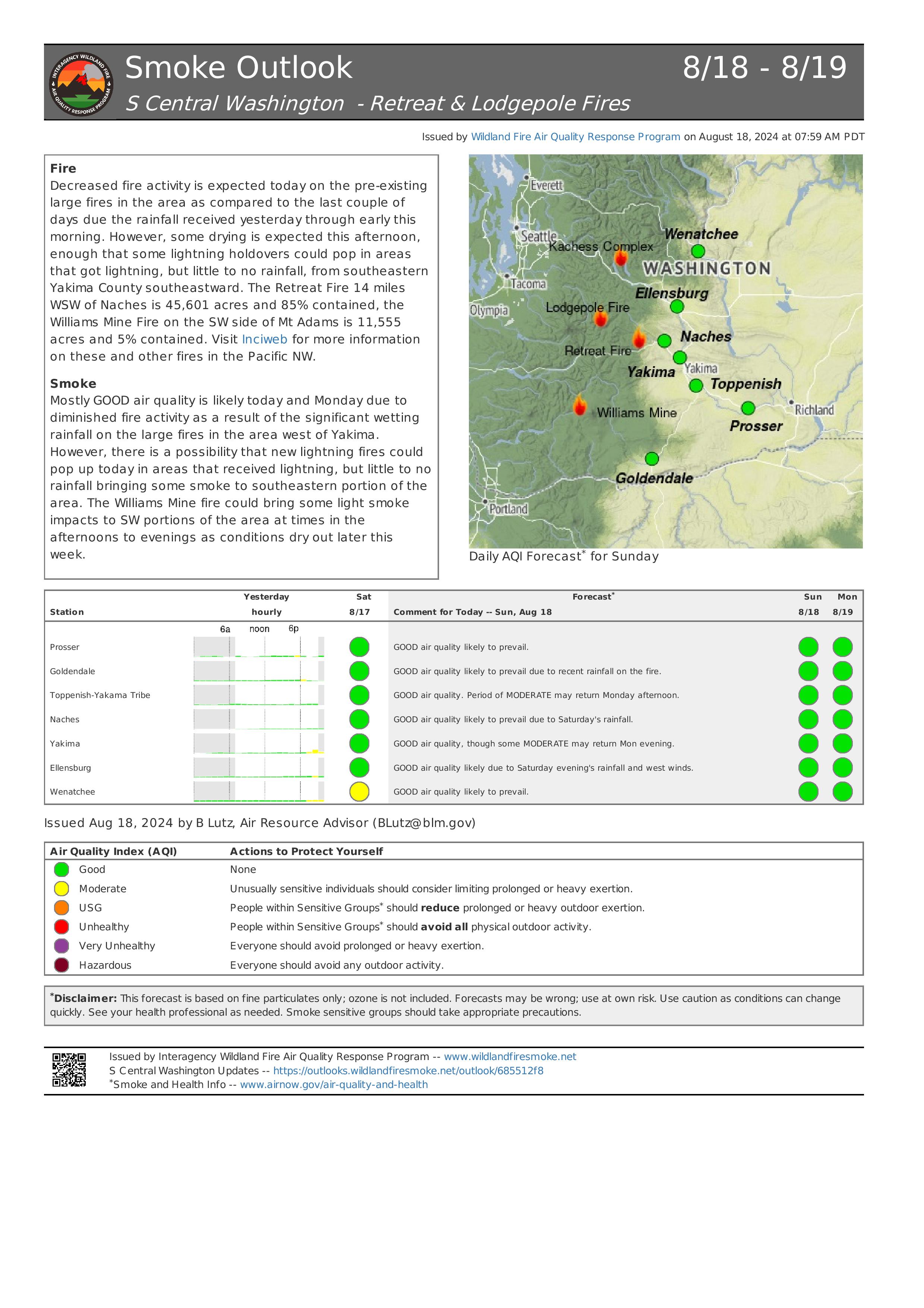
Retreat Fire Morning Update August 18 2024 08 18 2024
Related Incident: Retreat
Publication Type: News
Retreat Fire Morning Update - August 18, 2024
Phone: 509-213-4890, 8 a.m. to 8 p.m.
Email: 2024.Retreat@firenet.gov
Fire Information: linktr.ee/CIIMT14
Total Acres: 45,601 acres Containment: 85% Total Personnel: 317
Current Situation: Firefighters continue increasing containment on the Retreat Fire through diligent mop up and suppression operations. Crews have been patrolling the fire perimeter and ensuring there are no heat sources left that would threaten the security of control lines. As these control lines are tested and patrolled with no issues, firefighters make the determination to deem sections contained.
Today, firefighters will continue to patrol containment lines, extinguish any remaining hot spots they find, fall hazard trees along internal road systems, remove materials (logs and brush) left from preparing the shaded fuel break along Forest Roads 1200 and 1201, and remove unneeded equipment and fire hose from the fire area. Crews will survey the area for any issues created by last night’s thunderstorms.
The Washington State Department of Transportation reopened US 12 at 8:00 a.m. on August 17, 2024. Travelers should plan for added travel time due to single-lane, alternating one-way traffic as WSDOT and emergency contractor crews work to replace guardrail and highway signs along US 12 between mileposts 185, near the junction with State Route 410 and milepost 168, near the Tieton Road intersection. The public is reminded that multiple fire closures for the area are still in place (see Fire Closures below).
The final Incident Update for the Retreat Fire will be posted on Monday, August 19, 2024. California Interagency Incident Management Team 14 will transition command of the incident back to the local units at the end of shift on Monday. If there are any significant changes with the Retreat Fire, the local units will share pertinent information on their website and social media platforms.
Weather: Wetting rains covered much of the fire area due to multiple thunderstorms passing through last night. Today will be partly sunny with slightly cooler temperatures (70-78 degrees). A slight chance of showers exists for this morning and the possibility of some clouds this afternoon. Light winds are forecasted throughout the day. Tonight, we will return to mostly clear skies.
Evacuations: All evacuation orders for the Retreat Fire have been lifted as of August 16, 2024.
Fire Closures:
- Okanogan-Wenatchee National Forest Retreat Fire Closure (tinyurl.com/5ext5aec).
- The Washington State Department of Natural Resources (DNR) Southeast Region has temporarily closed part of the Ahtanum State Forest. The public can access the most up-to-date closure information at dnr.wa.gov/ahtanum.
- Washington Department of Fish and Wildlife has closed the majority of the Oak Creek Wildlife Area to public access due to the Retreat Fire until August 23, 2024. More information can be found at tinyurl.com/bdet7845.
Air Quality and Smoke: Air quality and smoke condition outlooks can be found at airnow.gov.
Red Fire Daily Update 08182024 08 18 2024
Related Incident: Red Fire
Publication Type: News
RED FIRE DAILY UPDATE
Sunday, August 18, 2024
541-208-1766, 2024.red@firenet.gov
https://inciweb.wildfire.gov/incident-information/ordef-red-fire https://www.facebook.com/2024RedFireOR/
Size: 730 acres Location: 5 miles west of Crescent Lake Junction, OR County: Klamath
Start Date: July 17, 2024 Cause: Lightning Containment: 0% Total Personnel: 244
Crescent, OR – The Red Fire is burning within the Diamond Peak Wilderness of the Deschutes National Forest, on the southwest slope of Redtop Mountain. The fire is being managed under a full suppression strategy. Public and firefighter safety is the highest priority in managing this fire.
Shaded Fuel Break Phases – Firefighters are completing the shaded fuel break in three phases Phase 1 includes cutting and stacking selected trees using logging equipment; Phase 2 includes limbing, trimming, and removing cut trees off site; and Phase 3 includes masticating brush and tree limbs to remove and reduce vegetation that could be fuel for the fire.
Yesterday’s Activities – Phase 3 of the shaded fuel break is 100% complete spanning from the railroad near Odell Lake to the Crescent Lake Snowpark. Phase 1 is nearly complete, and progress continued along the Crescent Lake Summer Homes. Team members from Northern Rockies Incident Management Team 8 arrived and received an overview of the fire in preparation for the transition of command.
Today’s Activities – The Southern Area Gray Team is happy to welcome the Northern Rockies Incident Management Team 8 to Oregon. Today, they will shadow the Southern Area Gray Team members as they coordinate their transition into leadership roles and prepare to assume command of the fire on Monday, August 19, at 6 a.m. Crews will continue implementation of Phases 1 and 2 around the fire area in coordination with heavy equipment.
Weather and Smoke – Winds are expected to be around 7-10 mph out of the west with temperatures in the mid-60s in the fire area. The fire will continue to creep and smolder. Air quality information can be found at https://fire.airnow.gov/.
Closures – The Deschutes National Forest has implemented an emergency closure around Crescent Lake and in the Diamond Peak Wilderness. The public should note that Forest Service Road 60 is closed, and road guards have been posted for public safety. More closure information is available at: https://www.fsa.gov/alerts/deschutes/alerts-notices/?aid=89091
Evacuations – The WILDFIRE! Level 1 – BE READY to Evacuate notice issued by Klamath County Emergency Management for the Crescent Lake, Odell Lake, and Crescent Junction areas remains in effect
(INCENDIO FORESTAL! Nivel 1 - ESTÉ PREPARADO para evacuar de las siguientes zonas: Crescent Lake, Odell Lake, Crescent Junction). Visit www.klamathcounty.org/300/emergency-management for more information or to sign up for alerts.
Fire Restrictions – Stage 2 Public Use Fire Restrictions – which prohibit open fires, including in developed campgrounds – are in effect for the Deschutes National Forest. The Industrial Fire Precaution Level is currently Level IV “General Shutdown.” Visit fs.usda.gov/detail/deschutes/home/?cid=stelprdb5297376 for more information.
Drone Restrictions – Aerial firefighting is suspended when unauthorized drones (UAS) are in the area. Unauthorized drone use over a fire area poses serious risks to fire personnel and the effectiveness of wildfire suppression operations. If you fly, we can’t.
Willamette Complex North Ore Pyramid Fires Daily Update 08 18 2024
Related Incident: North Willamette Complex
Publication Type: News
Willamette Complex North
Ore & Pyramid Fires
Incident Update
Date: Sunday, August 18, 2024
SPECIAL NOTE
State Route OR-126 is expected to be closed for 48 hours from 7 a.m. 8/20 through 7 a.m. 8/22 for road repaving from mile marker 13 to 19.8. This will impact travel East of Belknap Springs. OR-20 and OR-58 are recommended as full detours around the closure; vehicles over 35 feet long are not allowed on OR-242.
CURRENT SITUATION
Thunderstorms moved through the fire areas yesterday afternoon bringing significant precipitation, windy conditions, and blowing down trees. Today, crews will work on safely navigating access, removing downed trees, and reengaging on the fires. Infrared flights are still showing heat within the fire perimeters, though fire behavior is expected to be reduced today, as wet fuels take time to dry. Moderate fire behavior and weather conditions are predicted in the immediate forecast.
Ore Fire
Blue River, 3,093 Acres, 14% Contained, 547 Total Personnel, Human Caused
Crews were pulled off the line yesterday afternoon ahead of the thunderstorm activity and today will work to mitigate fallen trees to reengage on the fire. The Ore Fire received approximately .8 of an inch of rain in the past 24 hours. Current conditions will allow crews to work on further securing the fire containment lines.
Pyramid Fire
East of Middle Santiam Wilderness, 1,320 Acres, 76% Contained, 283 Total Personnel, Lightning Caused
The Pyramid Fire received nearly an inch of rain in the past 24 hours. Today, crews will work to safely navigate access to the fire, mitigate any hazards, and continue mopping up, patrolling, and securing containment lines where possible.
WEATHER AND FIRE BEHAVIOR
Conditions will be calm today compared to yesterday. Scattered mid-level clouds, remnants from yesterday’s thunderstorms will keep conditions cool and moist. Predicted maximum temperatures are 70-74° F in the valleys and 64-68°F on the ridgetops. Predicted minimum relative humidity is expected to be 48-54% in the valleys and 62-68% on the ridgetops. For smoke and air quality conditions visit: AirNow.gov
EVACUATIONS, CLOSURES, AND RESTRICTIONS:
On July 17th, the Linn County Sheriff’s Office, in coordination with the Willamette National Forest, issued a Level 3: Go Now Evacuation Alert for the closure area affected. Please refer to the Linn County Fire Map tinyurl.com/LinnCoFireMap for full details of the issued evacuation area (which will appear in red). To sign up for evacuation alerts, visit linnsheriff.org/.
Area, road, trail, and recreation site closures are in effect in the Willamette National Forest.
Specific information is posted at https://www.fs.usda.gov/alerts/willamette/alerts-notices/?aid=61574.
Fire restrictions are in effect for Willamette National Forest. Read the complete restrictions at: https://www.fs.usda.gov/alerts/willamette/alerts-notices/?aid=81487.
Wildfires are a no-fly zone for unauthorized aircraft, including drones. If you fly, we can’t.
For more information, visit http://knowbeforeyoufly.org.