
Ruby Fire Daily Update for August 18 2024 08 18 2024
Related Incident: Ruby Fire
Publication Type: News
Ruby Fire Update for August 18, 2024
Minnesota Incident Command System (MNICS) Incident Commander-Jeb Backe
Ruby Fire Quick Facts
Size: 820 acres Location: North Cascades National Park, Ruby Mountain, Diablo, Washington
Containment: 0% Cause: Lightning/Natural
Start Date: August 9, 2024, Total Personnel: 89
Fire Information
Inciweb: https://inciweb.wildfire.gov/incident-information/wancp-ruby-fire
Email: 2024.Ruby@firenet.gov
Facebook: https://www.facebook.com/people/Ruby-Fire/61563760546137/
Phone: 1-360-208-8096
Current Status: Yesterday, winds and high temperatures contributed to increased fire behavior, and moderate smoke spread throughout the area. The fire area received 3/8” precipitation last night, and fire managers are assessing impacts from the storm and will proceed with operations as safety permits. Fire access is difficult due to steep terrain and hazards.
Planned Actions: Firefighters will continue to protect values at risk in the fire area through structure protection around critical infrastructure, park campgrounds, trail infrastructure, backcountry camps, and other resources in preparation of fire growth. The Ruby Fire is a full suppression fire, and firefighters are utilizing strategies and tactics that provide the highest likelihood for success, while mitigating risks to firefighters and the public. Firefighting strategies and tactics are based on the available resources. The main objectives are protecting human life, minimizing damage to values at risk, and limiting wildfire spread to the north and west.
Weather: Sunday, cloudy skies in the morning with rain showers and thunderstorms. Then in the afternoon partially sunny with scattered rain showers and thunderstorms. Southerly winds 4 to 8 mph gusts to 12 mph. High near 72. Overnight partially clear with isolated rain showers. Lows near 58.
Closures: There are multiple closures in place for public safety. Colonial Creek South Campground and boat launch, Thunder Arm south of Route 20, and State Route 20 east of the park from MP 148 and MP 157, are closed. For a full list of closures visit https://go.nps.gov/fireclosures
Burning Restrictions: Campfires or the ignition of wood, briquettes, or any fuel in fire pits, fire pans and barbeque grills, are banned in all portions of North Cascades National Park Service Complex – North Cascades National Park, Ross Lake National Recreation Area, and Lake Chelan National Recreation Area. Drone Restrictions: Drones can seriously impact the safety of firefighting efforts, and operating drones within North Cascades National Park is prohibited, except with prior written approval from the superintendent.
Cooperating Agencies & Tribes: National Park Service, Upper Skagit Indian Tribe, Seattle City Light, Whatcom County, Whatcom County Sheriff’s Office, WA Dept. of Transportation.
Smoke: U.S. Interagency Wildland Fire Air Quality Response Program - Overall air quality will be good today in upper Skagit Valley. https://outlooks.wildlandfiresmoke.net/outlook/f79a6d6d, https://www.airnow.gov/
If you would like to sign up for our daily updates, please send an email to: 2024.Ruby@firenet.gov
Falls and Telephone Fires Update for Aug 18 2024 08 18 2024
Related Incident: Falls FireTelephone Fire
Publication Type: News
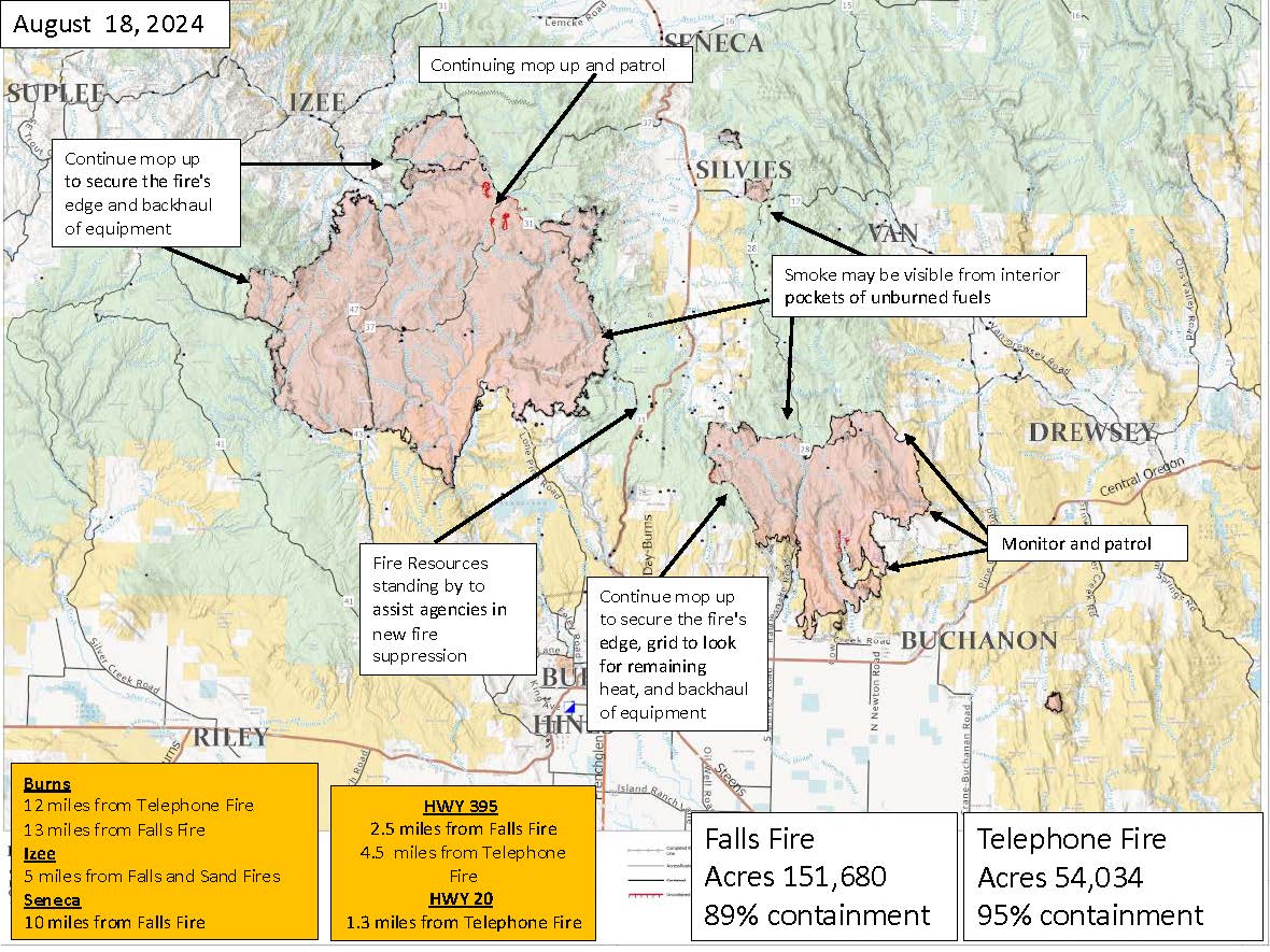
Falls and Telephone Fires Update for August 18, 2024
Given the current containment levels, this will be the final written update for the Falls and Telephone Fires unless conditions change. Firefighters will continue with mop-up operations, patrols, and hot spotting efforts to ensure the fire remains contained. Any potential flare-ups will be addressed promptly, and interior pockets may still produce smoke as they burn out. We will continue to share pictures and videos of activities into this week.
Telephone Fire Quick Facts:
Containment 95%
Size: 54,034 acres
Start Date: July 22, 2024
Location: 12 miles NE of Burns, OR
Cause: Lightning/Natural
Falls Fire Quick Facts:
Containment 95%
Size: 151,680 acres
Start Date: July 10, 2024
Location: 13 miles NW of Burns, OR
Cause: Human-caused
General Fire updates will continue on InciWeb at:
Falls Fire InciWeb: https://inciweb.wildfire.gov/incident.../ormaf-falls-fire
Telephone Fire InciWeb: https://inciweb.wildfire.gov/inciden.../ormaf-telephone-fire
Telephone and Falls Fires: Yesterday crews remained diligent as challenging weather conditions tested containment lines. Despite the red flag warning, there were no major changes to the fires. Today crews will monitor containment lines, improve mop-up depth, and continue to backhaul equipment from the fire area.
Interior unburned pockets of fuels continue to burn and produce smoke on Falls, Telephone and Poison Fires. The public is reminded that smoke and flames may be visible; as is common on fires of this size at this stage, and fire crews are monitoring these areas. No large fire growth is expected.
Weather: Winds will decrease today as cooler weather enters the area. The fire area remains dry, with low relative humidities. Moisture should increase by mid-week, with a small chance of wetting rains Wednesday through Friday.
Evacuations: For up-to-date information, visit the Harney County Sheriff’s evacuation map: https://bit.ly/FallsFireEvac, or the Grant County Emergency Management Facebook page: https://www.facebook.com/profile.php?id=100068819321423
Closures: A closure is in effect for the southern area of the Malheur National Forest. A closure map is available on the Malheur National Forest website (https://www.fs.usda.gov/detail/malheur/news-events/...).
Fire Information Line: 541-208-4370, staffed 8 a.m. to 8 p.m. Email: 2024.Falls@firenet.gov
Harney County Non-emergency Evacuation Questions: 541-589-5579
Air quality: https://fire.airnow.gov/
Smoke Outlooks: https://outlooks.airfire.org/outlook
Burns Interagency Fire Zone
Burns Paiute Tribe
U.S. Forest Service-Malheur National Forest
Harney County Emergency Management
Burns Fire Department
Hines VFD
Harney County Sheriff's Office
Grant County Emergency Management
Cougar Creek Daily Update 08 18 2024
Related Incident: Cougar Creek Fire
Publication Type: News
Cougar Creek Fire Daily Update
August 18, 2024
Quick Facts
Size: 24,091 acres Start Date: July 15, 2024 Cause: Under investigation
Location: SW of Clarkston, 1 mile west of Hwy 129 and Grand Ronde River intersection
Containment: 75% Personnel: 238 Fire Strategy: Full suppression
Resources Assigned: 4 crews, 18 engines, 8 water tenders, 3 heavy equipment
The Cougar Creek Fire is burning within a mountainous and remote area on the Umatilla National Forest bordering the Wenaha-Tucannon Wilderness.
Yesterday, falling modules continued the removal of danger trees between Mt. Horrible and Saddle Butte. Hand crews followed the wildland fallers to continue to search for remaining hot spots near the containment lines, extinguishing them when found. Given the steep and rugged terrain, crew safety and pace were evaluated to prevent injuries during operations. Along the 43 road, between the CCC camp and Indian Tom Corrals, wildland engine crews and hand crews backhauled remaining equipment and patrolled to ensure no hot spots were missed with gridding. Near Mountain View and Cougar Creek, rehabilitation of suppression activities, such as internal (not primary) dozer lines, continued.
A thunderstorm formed over the fire area last night, bringing up to a tenth of an inch of rainfall to the area.
Similar to yesterday, today’s operations will primarily focus on mop-up and rehabilitation. Crews will continue to patrol and backhaul equipment. As containment increased, crews are being demobilized and assigned to aid nearby wildfires or are returning to their home units.
Evacuations and Closures: FOREST ROAD CLOSURES HAVE BEEN REDUCED descriptions and maps are available online on the Umatilla National Forest closure website. Please respect area closure orders and use extra caution while driving for your safety as well as our firefighters. All evacuation orders have been lifted.
Weather and Smoke: High 79/Low 55: Today (Sunday) the threat of thunderstorms and rain will diminish leaving the fire area under mostly clear and drier conditions. Winds will decrease and be out of the southwest at 5 to 7 mph before shifting to the southeast at 5 mph around 4 PM. Daytime RHs will be moderate ranging from 30-40%. Tonight winds will shift to the north northwest and remain between 5 to 7 mph overnight. Overnight RH
recoveries will be good ranging from 46-51%. Monday winds will be quiet to start before shifting to the
north at 5 to 6 mph with daytime RH’s between 30-37%.
InciWeb: https://inciweb.wildfire.gov/incident-information/wases-cougar-creek-fire
Facebook: https://www.facebook.com/CougarCreekFire2024
Fire Information Line: 509-210-2928, 8 AM to 6 PM
Email: 2024.cougarcreek@firenet.gov
BAER INFORMATION VIDEO Borel PostFire BAER Team Releases What Is Baer Video 08 24 2024
Related Incident: Borel Post-Fire BAER
Publication Type: News
BAER INFORMATION VIDEO: Borel Post-Fire BAER Team Releases “What Is Baer” Video
The Forest Service—Sequoia National Forest and Bureau of Land Management (BLM) Interagency BAER team is completing its Burned Area Emergency Response (BAER) post-fire assessments of the Borel burned area and affected watersheds to determine their response, soil conditions, potential threats, and recommended BAER emergency stabilization measures and actions on National Forest System (NFS) and BLM lands.
BAER emergency treatments and activities are designed to decreased possible impacts to critical values from the burned areas during rainstorm events such as: life and safety, property, critical natural resources, and cultural resources.
The Borel BAER team along with the Borel Fire Incident Management Team PIO staff recently produced a video called “What is BAER?”. The video is posted to the Sequoia National Forest Facebook page: https://fb.watch/u8NdrgiAG9/, and is also available to view online on Vimeo at: What is the BAER TEAM? on Vimeo. The video is also available on this Borel Post-Fire BAER InciWeb page under the Videos tab.
BAER SAFETY MESSAGE: Everyone near and downstream from the burned areas should remain alert and stay updated on weather conditions that may result in heavy rains and increased water runoff. Flash flooding may occur quickly during heavy rain events--be prepared to act. Current weather and emergency notifications can be found at the National Weather Service website: www.weather.gov/hnx/.
###
Williams Mine Fire Update 08 18 2024
Related Incident: Williams Mine Fire-GPNF
Publication Type: News
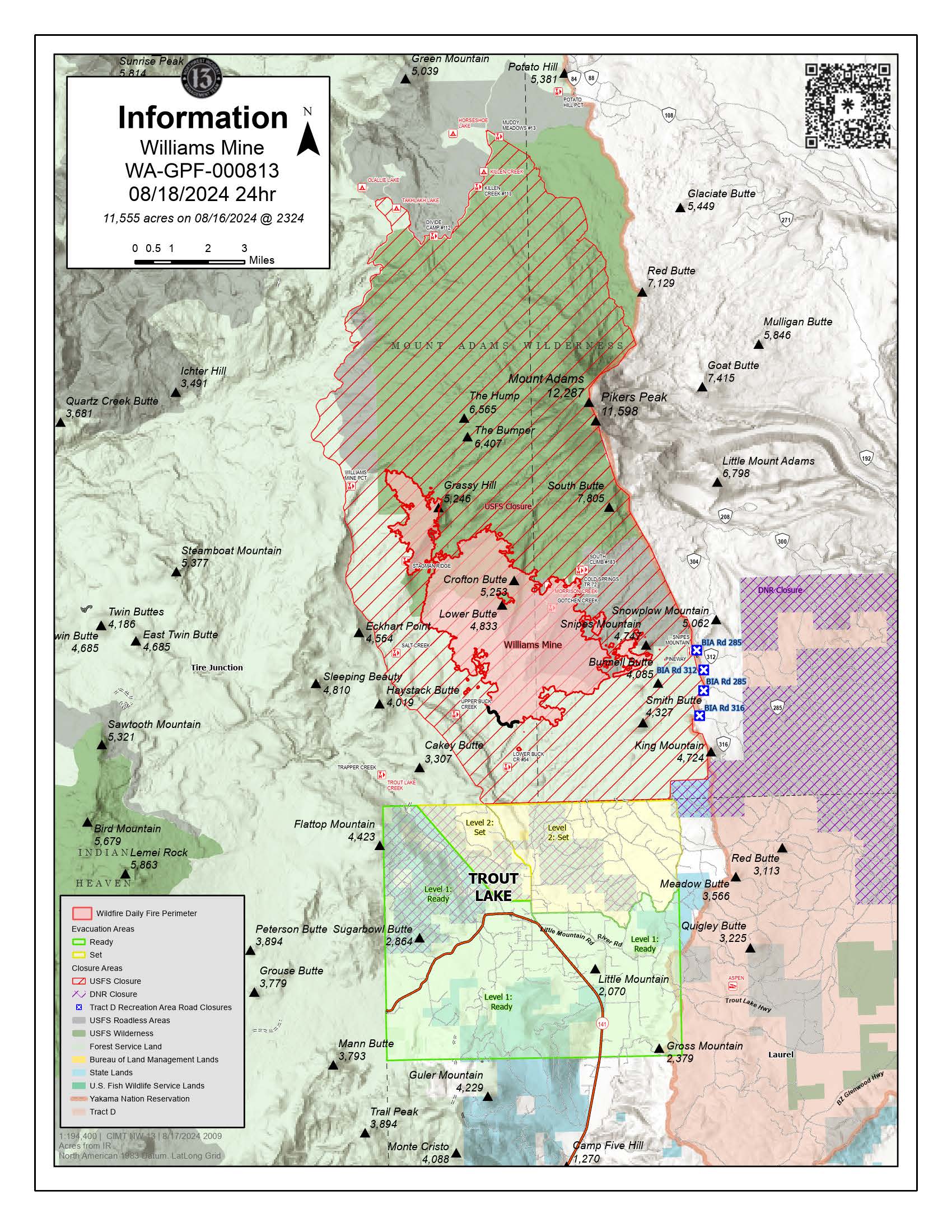
Williams Mine Fire Update for Sunday, August 18, 2024
CURRENT STATUS:
Yesterday’s thunderstorm produced an average of ½ inch of rain with lightning and 1-inch hail across Trout Lake and within parts of the fire perimeter. With concerns about lightning, rain, and strong winds creating the possibility of downed trees and powerlines, fire personnel were staged in safe locations during the storms, with strategic access points to assist with any new emerging incidents. Firefighters remained available for initial attack of any potential new fires from new lightning strikes. Night shift resources were also staged for the evening where they could stay safe but respond as needed. Aerial resources will be used today for recon to determine if any lightning strikes generated any new ignitions.
Today, crews are returning to the line to assess road conditions and continue securing the fire area. The added moisture from yesterday will expedite mop-up operations throughout the day.
Firefighters from the Yukon Territory in Canada arrived at the Williams Mine Fire and received a full incident briefing before beginning firefighting operations. This sharing of resources is critical during times when the National Preparedness Level is 5, the highest rating, due to lack of resources to commit to fires across the western United States. The international firefighting community has been essential in coordinated suppression efforts during the last several years of intense fire activity in the Pacific Northwest. Delegations from Australia, New Zealand, and Canada have provided personnel during the most active burning times of year to provide relief to local geographic areas.
WEATHER / FIRE BEHAVIOR:
The higher humidity and rain will reduce fire activity in the short term. Through the next few days, there may be an increase in fire activity as temperatures warm and fuels dry. This will likely occur in the larger dead and down fuels within the 2012 Cascade Creek and 2015 Cougar Creek fire burn scars, as well as under the canopy of trees where rain was unable to fully penetrate.
Today, temperatures will be moderate, with relative humidity in the 40% to 50% range accompanied by down slope gusting winds.
SAFETY AND CLOSURES:
Washington DNR managed lands near Trout Lake and Glenwood are closed to entry due to the Williams Mine Fire. For more information, please see http://www.dnr.wa.gov/ahtanum. The Confederated Tribes and Bands of the Yakama Nation, Tract D Recreation Area is closed, please see Yakama Tract D Road Closure for more information. Level 1 & 2 evacuations are in effect for the community of Trout Lake, and parts of Klickitat County. Evacuations are coordinated through the Klickitat County Sheriff’s Office and the Skamania County Sheriff’s Office. The FS-23 and FS-25 roads are closed, see the Williams Mine Area and Road Closure for more details. The Pacific Crest Trail (PCT) is closed from the PCT's intersection with FS 23 to Potato Hill. The current area closure spans the entire Mt. Adams Wilderness.
Black Canyon Fire Daily Update 08 18 2024
Related Incident:
Publication Type: News
Key Message
The current objectives have shifted to ensuring all fire personnel are well-rested, pacing themselves while performing duties, and identify and mitigate hazards on the fire line. Fire managers will verify and ensure the fire is 100% contained and controlled by Tuesday, August 20, through ongoing mop-up activities. The fire is currently 88% contained, with secure fire lines established around most of the perimeter. Extra resources have been demobilized or redirected to other priority incidents.
Current Status
Last night, an Infrared Awareness Assessment (IAA) flight detected a few isolated hot spots within the fire perimeter that crews will extinguish today.
Mop-up operations will continue, with firefighters having secured 88% of the fire perimeter, extending 300 feet into the interior. Crews will also patrol and monitor the fireline to mitigate any residual heat near the control lines. They will continue removing hoses, pumps, and equipment from the fireline when they are confident in its containment. An excavator will complete the repair and rehabilitation of previously constructed dozer continency lines northwest of the fire. The temporary flight restriction (TRF) over the fire area was lifted yesterday.
Weather and Fire Behavior
Fire behavior is minimal, with smoldering in the interior. Drying fuel conditions are expected today due to the return of warmer temperatures ranging from 82 to 87 degrees and high ridgetop winds up to 25 mph. The weather will be sunny, with a chance of scattered thunderstorms in the afternoon and variable southerly winds up to 10 mph.
Cottage GroveLane 1 Fire Update 08 18 2024
Related Incident: Lane 1 Fire
Publication Type: News
Rainy weather challenges firefighting efforts, provides opportunities
COTTAGE GROVE, Ore. – More than one inch of rain fell on the Cottage Grove – Lane 1 Fire Saturday afternoon during passing thunderstorms. These storms produced abundant lightning across western Oregon throughout the day.
As a safety precaution, firefighters left the fireline as thunderstorms passed through the area. Despite these challenging firefighting conditions, including a threat of flash flooding, containment increased today to 55%.
Boise Fire Update August 18 2024 08 18 2024
Related Incident: 2024 Boise Fire
Publication Type: News
Headlines:
- Join us for a virtual Ask the Incident Commander today at 2:00 p.m. to ask questions about the fire. We will be live on YouTube at https://www.youtube.com/live/CvMVI-e3Jn4?feature=shared.
- We will be conducting a helibase tour on Tuesday, August 20 at 10 a.m. at the Helibase in Willow Creek. Sign up required, please visit: https://forms.office.com/g/8n6gJDywJN to sign up.
- The Salmon River Road will have traffic control most likely starting Monday or Tuesday morning, with one-way piloted traffic 24 hours per day.
- Fire information phone: 707 572-4860 or email at 2024.Boise@firenet.gov
- Get all your Boise Fire information in one mobile-friendly place! https://linktr.ee/2024boisefiresrf .
- Evacuations are in place for the Boise Fire for residents near the fire area in Humboldt County. For the most current evacuation information please visit the Boise Fire linktree or visit--
- Humboldt County: https://humboldtgov.org/356/Office-of-Emergency-Services
- Siskiyou County: https://www.co.siskiyou.ca.us/emergencyservices
Leader’s Intent: The Boise Fire is being managed with a full suppression strategy.
Operational Update: Fire activity remained minimal overnight with relative humidity remaining near 100%. The fire continues to hold well on its west and north sides, and crews will continue to mop up and patrol those lines. A slopover was observed day before yesterday on the south side of the fire in the Trinity Alps Wilderness over the Lubbs Creek Trail north of the North Fork of Red Cap Creek. That slop was determined to be about 20 acres. Crews got in there and started to put in containment line yesterday, and they will continue to improve that and get hose lays onto it today.
A large contingent of crews and equipment moved into the spike camp at Nordheimer Flat to continue working from there west to tie into the Orleans Mountain Road across the top of the fire. Firefighters also worked north from High Point Ridge to improve and plumb handline up the proposed eastern containment line. They are also looking for opportunities to tie the southeastern edge of the fire into that eastern containment line. Multiple engines have arrived in the last two days, and they will continue assessing structures along the Salmon River corridor today.
Weather and Fire Behavior: Yesterday’s storm is predicted to pass through the area by mid-day today, and fuels are expected to dry quickly. However, temperatures are expected to remain moderate into the work week, and crews will take advantage of these conditions in the next few days to hold existing containment lines and build and prepare indirect lines.
Dirt Road Fire Daily Update August 18 2024 08 18 2024
Related Incident: Dirt Road Fire
Publication Type: News
Dirt Road Fire Daily Update
Sunday, August 18, 2024
August 18, 2024
Size: 1500 acres
Containment: 65%
Date Started: August 16, 2024
Cause: Undetermined
Structures: At this time crews have not identified any damaged structures.
Evacuations: There are no evacuations in place at this time.
The Dirt Road Fire started on August 16th, 2024 approximately 20 miles east of Spur, Texas. Local fire departments initially responded to this fire and requested assistance from Texas A&M Forest Service to provide additional engines, aviation resources, and heavy Equipment on August 15th at 7:20PM.
Crews are using heavy equipment to construct containment lines, areas cleared of any kind of combustible material, around the perimeter of the fire, stopping any further spread. Engines are working along these lines, putting out any active flames and identifying any heat to ensure that fire can not cross back over the containment lines. Aviation Resources are assisting to extinguish hot areas of the fire and monitor fire spread.
Closures: There are no road closures at this time.
Yesterday: Firefighters worked in high heat yesterday working to create containment lines and extinguish areas of heat. Fire activity was moderate initially yesterday and became more active over the course of the day. Forward progression of the fire moved quickly, making containment difficult. Aviation resources were utilized to assist with the forward progression of the fire that became more active after a day of high temperatures and low relative humidity.
Today: Resources are back on scene again today, working to complete fuel break lines and extinguishing the hot areas of the fire.
Weather and Fire Behavior: Temperatures are forecasted to be in the triple digits again today which will dry grass and brush, potentially making them more available for fires. Relative humidities will be extremely low. With higher winds forecasted crews will be looking for more active behavior potentially and actively patrolling to ensure there are no new spot fires and that containment lines are holding.
Fire Information
Information Officer
Texas A&M Forest Service
Email: information@tfs.tamu.edu
979-255-0591
Inciweb: https://inciweb.wildfire.gov/incident-information/txtxs-paint-crossing
Facebook: https://www.facebook.com/AllHazardsTFS
Twitter: https://twitter.com/AllHazardsTFS
Warner Peak Fire Daily Update August 18 2024 08 18 2024
Related Incident: Warner Peak Fire
Publication Type: News
Acres: 65,411
Start Date: 08/05/24
Location: Lake County, OR
Personnel: 371
Containment: 67%
Highlights: Containment lines held yesterday as high winds and red flag conditions tested areas of heat that became visible with the conditions. The fire did not make any significant runs or spot over the established perimeters. The increased acreage is due to more accurate mapping and areas burning within the containment lines.
Fire Activity: Firefighters continue patrolling and extinguishing any sources of heat near containment lines. Crews and equipment will focus on suppression repair efforts along the northern and eastern perimeters, returning areas, such as fire lines, to as natural state as possible. Hot spots on the south and southwest portions of the fire that may have been smoldering and undetected were visible as fire behavior increased with yesterday’s hotter and drier weather conditions.
Today, while there is no forecasted fire weather warning, we expect near critical conditions. Perimeter growth is not expected, but high winds and low relative humidities will increase burning, especially interior pockets of under burned fuel. Crews will continue direct attack on the western and southern perimeters. As winds increase in the late afternoon eastern portions of the fire could see increased activity as embers are blown from interior burning. Aviation resources may continue to be limited due to the weather forecast for strong gusts.
Closures: The Hart Mountain National Antelope Refuge is closed for public and firefighter safety.
In coordination with the Southwest Area Incident Management Team, the Lake County Sheriff’s Office has issued evacuation orders for the Hart Mountain area in support of firefighting efforts on the Warner Peak Fire. For detailed information visit www.lakecountyor.org.
Weather: Overnight there was continued gusty winds especially on the ridgelines. Elevated fire weather concerns with gusty winds and humidity in the low teens but falls short of warning criteria. Gusty winds are expected for much of the day on the ridgelines with gusts nearing 40mph. Valley locations will see slightly lower values with gusts to 30mph.
Smoke: Wildfire smoke from the Warner Peak Fire may impact the community of Plush and surrounding areas.Go to www.airnow.gov to see the latest smoke conditions in your community.
More Information:
Information Phone Line: 541.208.1770
Email: 2024.warnerpeak@firenet.gov
Facebook: facebook.com/warnerpeakfire
Inciweb: inciweb.wildfire.gov/incident-information/orshr-warner-peak