
Crazy Creek Fire Daily update for August 18 2024 08 18 2024
Related Incident: Crazy Creek
Publication Type: News
Crazy Creek Stands the Test of Time: Lines Hold After 50 mph Wind Gusts
Daily Update August 18, 2024
Fire Information Phone: 541-208-1768 (8 a.m.-8 p.m.)
Email: 2024.crazycreek@firenet.gov
Acres: Crazy Creek – 86,928; 93% contained
Kitty Creek – 73; 100% contained
Location: Crazy Creek: 5 miles north of Paulina, Oregon; 498/Kitty Creek: 7 miles south of Mitchell, Oregon
Start Date: July 22, 2024 Personnel: 564
Resources: 17 crews | 0 helicopters | 21 engines | 6 bulldozers | 18 water tenders | 1 masticator |
6 skid steers
Highlights: Wind gusts up to 50 miles an hour were recorded Aug. 17 over the Crazy Creek Fire, but containment lines held. The fire remains at 86,928 acres, with containment increasing to 93 percent.
The stronger wind speeds rekindled larger heat sources within the interior of the fire, such as burned tree stumps and logs, but there were no reports of spreading flames.
Firefighters will remain on patrol to maintain current containment lines and extinguish interior hot spots as lower humidity levels are making smaller-diameter vegetation and debris more susceptible to ignitions. Crews are also rehabilitating fire lines around both the Kitty Creek and Crazy Creek Fires to return them to a more natural state.
Evacuations: The Crook County Sheriff’s Office has lowered the evacuation level from Level 3 (recommended evacuation) to Level 2 (set for evacuation) from Highway 380 north to SE Puett Road. The area north of SE Puett Road around the perimeter of the fire remains at a Level 3. The area south of Highway 380 has been lowered to Level 1 (prepare for possible evacuation). An evacuation map is available online through the Crook County Emergency Management Office website.
Weather: We can expect hot, dry, and windy conditions into next early next week. Temperatures will remain close to the same as well as humidity down into the teens. Winds are expected to remain around the 10 to 15 miles per hour range, but become less frequent.
Importance of Fire Prevention: All public lands in Central Oregon, including the Ochoco National Forest, are in Stage 2 Public Use (Fire) Restrictions. All open flames, including woodstoves and charcoal briquette fires, are prohibited. In times of high fire danger, it is crucial for everyone to follow prevention measures to avoid additional strain on overburdened resources.
Fire Restrictions and Closures: The Ochoco National Forest has implemented a forest closure for the eastern portion of the Paulina Ranger District. The Bureau of Land Management has issued a temporary closure for portions of public lands in Crook and Grant Counties.
More Information:
InciWeb: https://inciweb.wildfire.gov/incident-information/orocf-crazy-creek
Facebook: Facebook.com/Crazy Creek Fire
Central Oregon Wildfire Information: https://centraloregonfire.org/
Battle Mountain Complex Daily Update 08 18 2024
Related Incident: Battle Mountain Complex
Publication Type: News
Firefighters moving out of Long Creek camp
Total Complex Estimated Acres: 183,026
Location: Ukiah, Oregon
Cause: Under Investigation
Personnel: 748
Containment: 94%
Estimated Cost: $77 million
Resources: 10 crews | 15 engines | 1 helicopter | 21 water tenders | 13 dozers
Operations: Equipment and crews continue building erosion control features on dozer and hand lines. Where available, cut brush is being dragged on top of firelines to prevent erosion and allow vegetation to regrow. As repair work is finished it is inspected by local agencies. North of the fire, equipment operators continue removing brush and trees along roads. The goal is still to leave areas fully repaired and follow through with the back-up firelines around Penland Lake that were started during the height of suppression.
The remainder of the Long Creek fire camp will be dismantled today. Firefighters working from Long Creek will relocate to Ukiah. Others will leave the incident to travel home. As crews and equipment are leaving the incident, residents may see increased traffic over the next several days. Use caution when driving especially on blind curves where lowboy trailers may be traveling.
There is still high fire danger in the area. Fuels remain dry, and any new fire starts have the potential for rapid growth. Firefighters assigned to the Battle Mountain Complex are ready to respond to any new fires in the area, but residents should be aware of local fire restrictions.
Weather: Today is expected to be mostly sunny with little chance of rain or thunderstorms. Temperatures will be in the high 70s to low 90s. Winds will be light and variable for the southwest in the morning before increasing from the northwest late afternoon. Humidities are expected to continue increasing during the nights, reducing any remaining fire activity.
Smoke: Smoke has moderated but is expected to persist from regional fires in the area. Residents may see smoldering from interior pockets of unburned fuel or haze from other fires in the region. To see a detailed smoke outlook visit: https://linktr.ee/battlemntcomplex2024
Public Land Closures: Both the Bureau of Land Management and U.S. Forest Service have either rescinded or reduced closure orders for public lands. Visit https://linktr.ee/battlemntcomplex2024 for more information.
Road closures and fire restrictions: https://linktr.ee/battlemntcomplex2024
Grant, Morrow and Umatilla County Evacuations: https://linktr.ee/battlemntcomplex2024
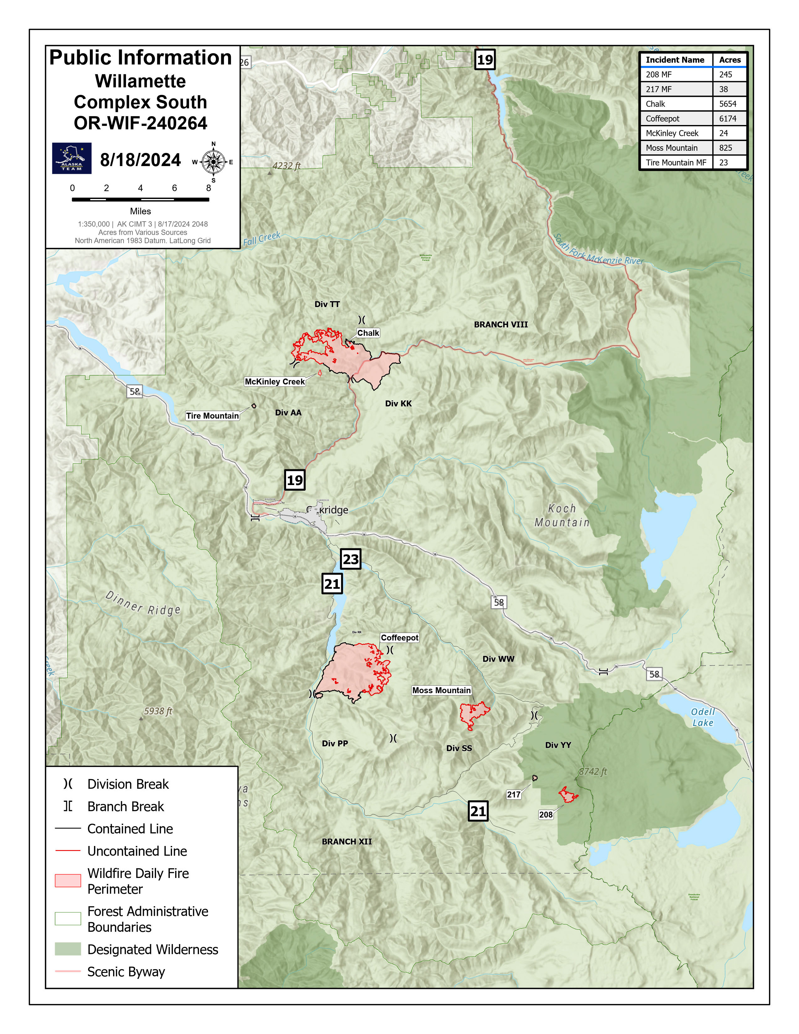
Willamette Complex South Daily Update Sunday 08 18 2024
Related Incident: Willamette Complex Fires - South
Publication Type: News
Sunday, August 18, 2024
Total Willamette Complex South Personnel: 876
Total Willamette Complex South Acres: 12,945
Resources: 3 Type 1 Hotshot Crews, 22 Type 2 Crews, 3 Type 2 Initial Attack Crews, 25 Type 6 Engines, 14 Dozers, 10 Masticators, and 1 Skid Steer
Fire Cause: Lightning
Summary
Saturday, the Willamette Complex Fires South experienced scattered, heavy rainfall, calming fire behavior. Crews are continuing to secure containment lines, ensuring that the fireline is not breached by debris. Their efforts are aided by heavy machinery and the mapping provided by the thermal imaging capabilities of uncrewed aircraft systems (UAS). In addition, initial attack crews will assist the Willamette National Forest with new lighting starts, as needed.
Chalk Fire (5,654 acres, 57% containment)
Areas around the Chalk Fire received over a half inch of rain. On the southwest section of the fire, crews will continue to improve completed control lines, working west along Forest Road 1912 and tying back into the main body of the fire on Forest Road 1925. UAS will be used for strategic firing operations as conditions allow.
Coffeepot Fire (6,174 acres, 58% containment)
The Coffeepot fire experienced high levels of precipitation Saturday evening, with quarter sized hail and received over a quarter inch of rain. Crews on the Coffeepot Fire are improving control lines and are continuing to secure the unburned island that remains on the southeast section of the fire.
Moss Mountain Fire (825 acres, 0% containment)
A weather station near Moss Mountain received a quarter of an inch of rain on Saturday. Crews are working to secure spots south of Forest Road 2120 and connect it into the main body of the fire. UAS will be used to identify hot spots for search and destroy missions, as conditions allow.
208 Fire (245 acres, 0% containment)
The 208 Fire in the Diamond Peak Wilderness is unstaffed and monitored by air.
217 Fire, Tire Mountain Fire, and McKinley Fire
The 217, Tire Mountain, and McKinley fires are 100% contained. Fire managers are continuing to monitor.
Weather and Fire Behavior
Some areas of the Willamette Complex received upwards of a half inch of rain from Saturday afternoon showers. While the rain subdued fire activity and made fine fuels less combustible, heavy fuels will continue to burn. Wet ground may increase the chance of burning trees falling across containment lines.
Closures and Fire Restrictions
Area, road, trail, and recreation site closures are in place on the Willamette National Forest in the vicinity of many active fires. Temporary road barricades are in place to restrict traffic across the fire areas.
- For specific closure information visit tinyurl.com/WillFireClosures2024
- For current fire restrictions visit tinyurl.com/WillFireRestrictions2024
Temporary Flight Restrictions (TFR) are in place over the Chalk, Coffeepot, and Moss Mountain Fires. Visit tfr.faa.gov for up-to-date areas. Wildfires are a no-fly zone for unauthorized aircraft, including drones. For more information, visit knowbeforeyoufly.org.
For More Information
Phone: (541) 208-1742, 8 a.m. to 8 p.m.
Email: 2024.willamettecomplex@firenet.gov
InciWeb: https://inciweb.wildfire.gov/incident-information/orwif-willamette-complex-fires-south
Facebook: https://www.facebook.com/WillametteComplexFires
YouTube Channel: https://www.youtube.com/@WillametteComplexFiresSouth
Dixon Fire Evening Update 8182024 08 18 2024
Related Incident: Dixon Fire
Publication Type: News
Firefighters Continue Advantage as Rains Soak Fire Area
DAYS CREEK, Ore. – Fire crews took full advantage of today’s wet weather conditions to further improve containment on the Dixon Fire. Afternoon storms dropped about a quarter of an inch of rain over the fire area, reducing hot spots. Due to reduced fire activity, reduced public interest, and increased containment this will be the last evening update. Morning updates will continue.
Crews investigated one reported lightning strike near the eastern section of the fire and will continue to monitor for any new ignitions. Initial attack will be provided as needed. Night crews will work to identify and extinguish remaining hot spots.
Today the Douglas Forest Protective Association announced a decrease in Public Use Restrictions to MODERATE and a decrease to LEVEL 2 for Industrial Fire Protection Levels. Restrictions on open burning remain in effect. Area residents should remain vigilant and practice fire prevention.
Evacuation levels, managed by the Douglas County Sheriff, were further downgraded this afternoon. Please stay up to date on evacuation levels at: http://www.dcso.com/evacuations
As fire activity decreases, some fire personnel and equipment are beginning to demobilize and return to their home units, providing them opportunity for much needed rest and making them available for future response.
Fire Prevention: Know Before You Go - It Only Takes One Spark. Public and industrial restrictions are in place to help prevent wildfires:
• Umpqua National Forest: https://www.fs.usda.gov/main/umpqua/fire
• Oregon Department of Forestry: https://www.oregon.gov/odf/fire/pages/restrictions.aspx
• Douglas Forest Protective Association: https://www.dfpa.net/public-fire-restrictions
Road Update: The Tiller Trail Highway is open; however, with severe weather in the area, check conditions before you travel. Use Tripcheck to plan ahead: https://tripcheck.com/
Forest Closures: There are two forest closures impacting every district of the Umpqua National Forest. Closure information: https://www.fs.usda.gov/alerts/umpqua/alerts-notices
Smoke Outlook: https://fire.airnow.gov/#
Infrastructure Update: Power has been restored to the Crume Ranch Lane area. Pacific Power is continuing to work on restoring power to the rest of the fire area and providing updates to impacted customers via phone/email/text.
For information on current outages, visit:
• https://www.pacificpower.net/outages-safety.html
• En español: https://www.pacificpower.net/es/apagones.html
For information on wildfire mitigation and safety efforts, visit:
• https://www.pacificpower.net/outages-safety/wildfire-safety.html
For questions, please contact the Pacific Power Customer Service team at 1-888-221-7070.
Limepoint Fire Update Sunday 08 18 2024
Related Incident: Limepoint Fire
Publication Type: News
Limepoint Fire
Sunday, August 18, 2024
Contacts for Fire Information: 208-992-3032 or
2024.limepoint@firenet.gov
https://inciweb.wildfire.gov/incident-information/idpaf-limepoint-fire
https://www.facebook.com/payettenationalforest/
Yesterday, firefighters exercised increased vigilance due to the National Weather Service’s Red Flag Warning for hot, dry, and windy conditions and held existing containment lines. A small-scale burning operation in the northeastern portion of the fire was successfully implemented. Crews and equipment continued to make progress in securing and strengthening the perimeter of the fire and in conducting suppression repair work on the southern portion of the fire. Despite the potential for increased fire activity, yesterday proved to be a “relatively uneventful day,” according to Operations Section Chief Clay Stephens.
Today, weather conditions have moderated somewhat from yesterday. Firefighters will conduct additional limited burning operations to reduce grass and shrub fuels near the fire perimeter on the northern portion in the area between Lockwood Saddle and Kinney Point. Helicopters and Unmanned Aerial Systems (UAS) will continue to support firefighters on the ground. Removal of standing dead hazard trees along the Kleinschmidt Grade Road southwest of Cuprum will continue. Further south, work by hand crews and heavy equipment to repair the impacts of earlier fire suppression activities will continue in the vicinity of Barber Flats and Paradise Flat. Additional excavators will arrive on the incident today and begin work to minimize any environmental impacts in disturbed areas not needed for active suppression operations.
Evacuations: Evacuation levels set by the Adams County Sheriff continue unchanged. Cuprum remains at a Level 2 (SET) evacuation level. The Bear and Wildhorse communities remain at a Level 1 (READY) evacuation level. For your safety and the safety of firefighters, please stay away from the fire area. Only residents and property owners are allowed in the area until further notice.
Closures: The Forest Closure Order issued by the Payette National Forest to protect public safety near the fire area remains in effect. For more information about the closure, visit https://inciweb.wildfire.gov/incident-information/idpaf-limepoint-fire.
Restrictions: Stage 1 Fire Restrictions remain in effect for the Payette National Forest and all state, private andBLM lands in the fire area. Under these restrictions, campfires are allowed only in recreation sites within metal fire pits. Fires of any kind are not allowed in any dispersed camping areas.
West Mountain Complex Daily Update 08 18 2024
Related Incident: Boulder FireDollar Fire Wolf Creek Fire
Publication Type: News
The West Mountain Complex includes five fires- Boulder, Snag, Wolf Creek, Dollar, and Goat Fires. Read our daily update for more information. Scroll to the bottom of the page for PDF versions of the daily update, the daily map, and the daily smoke report.
QUICK FACTS
Fire | Location | Size | Containment | Start Date
Boulder | 9 miles SW of Cascade | 2,264 acres | 26% | 7/24/2024
Wolf Creek | 5 miles W of Donnelly | 1,154 acres | 90% | 7/24/2024
Snag | 11 miles E of Cascade | 20,948 acres | 0% | 8/5/2024
Dollar | 18 miles NE of Cascade | 1,814 acres | 0% | 8/5/2024
Goat | 11 miles SE of Cascade | 1,276 acres | 0% | 8/5/2024
Gabe | 9 miles SW of Cascade | 5 acres | 0% | 8/15/2024
Cause: Lightning (All Fires)
Total Incident Personnel: 925
Weather | Anticipated Fire Behavior:
Yesterday’s temperatures were warmer, settling around upper 70s to lower 80s. Humidity levels were lower, dropping to 15-20% by the afternoon. Windy conditions persisted throughout the day and evening, with heavy smoke affecting the area. Although fire managers expected increased fire activity yesterday, the heavy smoke acted like an inversion by stabilizing the lower atmosphere, ultimately leading to more moderate fire behavior. Beginning today, conditions are expected to remain moderate throughout early next week, but temperatures will remain warm. Low humidity levels are anticipated throughout the day today. Winds will gust around 20mph out of the southwest will persist in the area.
Boulder Fire: https://tinyurl.com/ycdfv3tv
Several spots were observed on the northeast perimeter throughout the day yesterday. However, fire crews were able to contain all spots of concern. The western perimeter of the fire is bordered by rock outcroppings, which effectively reduce the fire’s ability to spread. Fire crews on the Boulder Fire completed firing operations on the southeast perimeter, northwest of 421E Road.
Snag Fire: https://tinyurl.com/4k9dk3mu
The Valley County Sheriff’s Office, in coordination with Great Basin Incident Management Team 2, have established one-way escorts for residents and contractors through the Snag Fire affected areas. This escort will be provided for reasons of necessity and not for recreation purposes. For more information visit: https://tinyurl.com/mtartvas
Although fire behavior on the Snag Fire was less active than predicted, group torching of trees and surface burning was observed today. Heavy aviation resources were assigned to the fire throughout the day. Fire crews are working to plumb along the western portion of the fire along the Warm Lake Highway. Plumbing a fire means setting up a system of hoses, pumps, and water sources to control and contain it. This setup helps firefighters manage hotspots and prevent fire spread beyond established perimeters. Additionally, a masticator is being utilized along old containment lines that were previously used during a past wildfire event to reduce available fuel sources.
Wolf Creek Fire: https://tinyurl.com/mcksrfvh
Containment on the Wolf Creek Fire increased again today. Fire crews will continue to monitor the fire for internal heat. The interior of the fire continues to burn isolated pockets of timber and forest understory. Fire personnel are also working on rehabilitation of control lines. Military members of the 14th Brigade Engineer Battalion, a combat engineer battalion of the United States Army based at Joint Base Lewis-McChord in Washington, are training in firefighting tactics on the Wolf Creek Fire. After training completion, the battalion will be assigned to other fires being managed by the incident management team.
Dollar Fire: https://tinyurl.com/bef6r3tz
Fire activity on the Dollar Fire showed active surface burning with some isolated torching of trees. Fire crews worked on installing handlines along the southern perimeter of the fire. Installing handline is the process of removing available fuels down to mineral soil using firefighting hand tools to reduce the amount of burnable material. This suppression tactic will continue through the day today.
Goat Fire: https://tinyurl.com/2h4a3dvr
Aviation resources are tracking the Goat Fire’s spread northward toward the Snag Fire and eastward toward the Middle Fork Payette drainage. The western edge of the Goat Fire is adjacent to a previously burned area, which could help slow its progress. Fire managers are coordinating to allocate firefighting crews to the Goat Fire as progress is made on other fires being managed by the incident command team.
Gabe Fire:
The Gabe Fire is 100% contained. Ground crews and aviation resources worked throughout the day yesterday to ensure no further fire spread or heat were present. Fire managers will continue to monitor the area to ensure no further fire activity occurs.
SNAG FIRE EVACUATION INFORMATION
The Valley County Sheriff’s Office issued a “ready” evacuation order for Warm Lake residents and the North Shore Lodge at Warm Lake on August 7. The map can be found on Inciweb: https://tinyurl.com/42auxnk8. A second “ready” evacuation order was issued on August 8 for the Horsethief area, including the YMCA Camp, and areas of Scott Valley. This map can also be found on Inciweb, with the relevant areas outlined in purple: https://tinyurl.com/4vfj657x
Review the READY, SET, GO evacuation procedure for Valley County: https://www.co.valley.id.us/ReadySetGo
For timely information on evacuations, check out your county’s emergency alert system.
- Valley County: https://www.co.valley.id.us/CompleteEmergencyNotificationandAlerting
- Adams County: https://public.alertsense.com/SignUp/PublicUser.aspx?regionid=1077
ROAD CLOSURES
Warm Lake Highway Closure: The Valley County Sheriff’s Office has closed Warm Lake Highway due to the Snag Fire. The Warm Lake Highway is closed at the Horsethief Road intersection east toward Warm Lake and from the Johnson Creek Road intersection west toward Warm Lake. Scott Valley residents will be allowed access. For updates on county closures visit: https://www.co.valley.id.us/departments/SheriffsOffice.
FOREST CLOSURES
Hunting Closures: Prior to entering the backcountry, Idaho Fish and Game advises hunters to check with their local Forest Service ranger district offices or county sheriffs’ offices for fire closures in their hunt areas. For more information visit: https://tinyurl.com/4td8hwzc
August 12, 2024 update: The Boise National Forest has modified or expanded their wildfire closures to address public and firefighter safety and respond to increased wildfire growth. This new closure area begins at the south end of the Dollar/Oro (Snag) fire closure area and continues south to Crouch and the Banks-Lowman Hwy, and east to the 579, 563 and 582 roads.
Wolf Creek Fire Closures: On the Payette National Forest, a closure including popular National Forest System roads around the Wolf Creek fire such as: sections of NFS #1763 (West Mountain Jeep Trail), #835, #206, #326. On the Boise National Forest, Forest Road #435 (Anderson Lake Road) was closed on August 1.
Boulder Fire Closures: The Boise National Forest has issued a closure order #0402-04-98 for National Forest System (NFS) roads, trails and lands encompassing the Boulder Fire. The closure was enacted to protect public safety and support fire suppression activities. The closure includes Blue Lake and Snowbank Mountain Road (#446) along with all #404 and #421 system roads.
For maps and more detailed descriptions of the closures on the Payette National Forest, please visit: https://www.fs.usda.gov/alerts/payette/alerts-notices
For maps and more detailed descriptions of the closures on the Boise National Forest, please visit: https://www.fs.usda.gov/alerts/boise/alerts-notices
Fire Restrictions: Stage 1 Fire Restrictions have been issued for the Payette Fire Restrictions Area on the Payette National Forest and the West Central Mountains Fire Restrictions Area on the Boise National Forest. For more information on the restrictions and a very helpful interactive map, visit https://www.idl.idaho.gov/fire-management/fire-restrictions-finder/
Important Links
- Payette National Forest: https://www.fs.usda.gov/payette
- Payette National Forest Facebook: https://www.facebook.com/PayetteNationalForest
- Boise National Forest: https://www.fs.usda.gov/boise
- Boise National Forest Facebook: https://www.facebook.com/BoiseNationalForest
- Idaho Department of Lands: https://www.idl.idaho.gov/fire-management/
Park Fire Evening Update for August 17 08 17 2024
Related Incident: Park Fire
Publication Type: News
Park Fire Morning Update for August 17 is posted on the Park Fire Status Update Page
Coffeepot Fire Update 08 18 2024
Related Incident: Coffee Pot Fire
Publication Type: News
Today the Coffeepot Fire grew to 452 acres. Crews continue to work on handline and scouting the landscape. Water drops with aircraft continue.
Today Complex Incident Management Team 5 arrived and participated in an in-brief with NPS and other local agencies. This team will take over management of the fire tomorrow morning under Unified Command with NPS and Cal Fire.
Reminder that we have scheduled a public meeting for tomorrow evening.
Coffeepot Fire Public Meeting
Sunday, August 18 at 6pm
Three Rivers Memorial Building
If possible, the team will try to host the meeting using Sequoia and Kings Canyon's Facebook Live so more people are able to participate, but that is dependent on resources getting approved. An update about this will go out in tomorrow morning's fire update.
Fire updates will likely be sent each morning moving forward, opposed to the evening updates we've been doing. Team 5 will be sending these out.
Efforts to suppress this wildfire include 110 fire personnel, one fire engine, 5 helicopters, and multiple fixed-wing air tankers, with many more resources being requested and filled daily.
Grouse Fire Information 08 17 2024
Related Incident: Grouse
Publication Type: Announcement
The Beaverhead-Deerlodge NF, with a local Type 4 Incident Commander, has assumed command of the Grouse Fire. For fire information, contact the Forest Fire PIO at 406-865-0941 or terina.hill@usda.gov.
Alexander Mountain Fire Reaches 100 Containment 08 17 2024
Related Incident:
Publication Type: News
Alexander Mountain Fire 100% Contained
FORT COLLINS, Colo. (Aug. 17, 2024)- Less than three weeks after the fire was first reported, the Alexander Mountain Fire has been declared 100% contained today, Saturday, August 17.
The Alexander Mountain Fire started on Monday, July 29, 2024, north of US Highway 34 and west of Loveland, Colorado. Evacuations and road closures were in effect for several days. A total of 28 homes and 21 outbuildings lost in the fire. Final acreage of the fire has been mapped at 9,668 acres.
US Highway 34 between Loveland and Estes Park fully reopened on August 8, 2024. All evacuation orders were lifted as of 10:48 a.m. on August 12, exactly two weeks from the time the Alexander Mountain Fire was first reported to dispatch.
"The Forest wants to recognize both the hard work as well as the stress and difficulty of the past three weeks." said Acting Forest Supervisor Jason Sieg. "There are members of the Cedar Park community who lost property and homes, and we will support them as best we can alongside our community partners and local agencies. We also want to thank the numerous agencies, partners, fire personnel and community members who stepped up to help in our joint coordination with Larimer County and Colorado Division of Fire Prevention and Control. This was a team effort. Thank you. As we move into the recovery phase of the work, we look forward to continuing to work together, and we know the work is not over."
With 100% containment, the fire is now considered in monitor status. Fire personnel will continue to be working and monitoring in the area, and the Burned Area Emergency Response (BAER) work continues. For more information on BAER work and what it entails, visit the BAER InciWeb Page.
Larimer County continues to provide assistance and support for those impacted by the Alexander Mountain Fire. To reach the Larimer County's Fire Recovery Line, call 970-980-2800, or visit https://www.larimer.gov/alexander-mountain-fire-recovery for additional information.
The Alexander Mountain Fire Area Closure remains in effect and Stage 2 Fire Restrictions remain in place until further notice.
Investigators are still accepting information regarding this human caused fire. Those with possible information about the start of the Alexander Mountain Fire are asked to call the Forest Service Law Enforcement Tip line at (303) 275-5266. Photos, videos and typed statements can also be uploaded to the US Forest Service LEI Evidence Submission Portal
To receive further email updates on forest health and fire in the area of the Alexander Mountain Fire, make sure to join our email list and select Forest Health & Fire: North of Hwy 34 to Hwy 14 (Buckhorn Canyon, Glen Haven, Cedar Park).