
Coffee Pot Fire Update 08 18 2024
Related Incident: Coffee Pot Fire
Publication Type: News
Fire Information: (559) 565-3341 Unit Hours: 09:00 AM to 5:00 PM
Location: West of Homers Nose on Salt Creek Ridge
Size: 621 acres, 0% contained, Personnel: 135, Cause: Lightning
COFFEE POT FIRE PUBLIC MEETING TONIGHT: A public meeting about the Coffee Pot Fire will be held tonight, August 18, at 6:00 p.m. The meeting will occur at the Three Rivers Memorial Building, 43490 Sierra Drive, Three Rivers. If you can't attend in person, you can watch the meeting live on the Sequoia and Kings Canyon National Parks Facebook page @SequoiaKingsNPS. And on YouTube: sequoia and kings canyon national park - YouTube
CURRENT SITUATION: As of 7:00 a.m., California Interagency Incident Management Team 5 and CALFIRE, Tulare Unit, have taken command of the Coffee Pot Fire. The fire is a full-suppression fire burning on lands managed by Sequoia and Kings Canyon National Parks and the Bureau of Land Management. Yesterday, the fire was actively burning down slope in steep, rugged terrain and doubling in size daily. Today, crews will begin establishing control lines on the south and west flanks around the fire's perimeter. Hand crews will start at South Fork Road on the west flank and construct a new indirect control line to the north. On the south flank, they will also construct a new indirect control line towards South Fork Road, approximately one mile from the park boundary. The purpose of the new control lines is to keep the fire away from the community of Three Rivers. On the east flank of the fire, firefighters will begin to scout opportunities to create indirect handlines away from the fire’s edge. They are also planning, if needed, a defensive firing operation to protect the Surprise Grove of Giant Sequoia. Firefighters will be aided by water-dropping helicopters.
WEATHER: The area is expected to have below-average temperatures for the rest of the weekend and the upcoming week. Light and variable winds from the west at 5 to 8 mph.
SMOKE IMPACTS: You can check how wildfire smoke impacts your area at: AirNow.gov
PUBLIC NOTICE: Wildfires are a no-fly zone for unauthorized aircraft, including drones. If you fly, we can’t. For more information, visit http://knowbeforeyoufly.org.
Actualizacin diaria del incendio Pioneer 18 de agosto de 2024 08 18 2024
Related Incident:
Publication Type: News
Actualización diaria del incendio Pioneer
18 de agosto de 2024
Tamaño: 38,727 acres (no se actualizaron las II)
Fecha de inicio: 8 de junio de 2024
Ubicación: 31 millas al NO de Chelan, WA
Contención: 23%
Personal: 679
Causa: A ser determinada
Recursos asignados: 7 equipos de obreros, 6 helicópteros, 21 camiones de bomberos, 25 tanques de agua, 11 maquinarias pesadas
SITUACIÓN ACTUAL: El incendio Pioneer continúa en el desague de Boulder Creek por debajo de las líneas de retardantes establecidas. El trabajo de las aeronaves aumentó a través del día a medida que se realizaban vuelos de ataque aéreo y reconocimiento y vertían retardantes y agua en las zonas de calor. Las cuadrillas revisaron las millas de manguera colocadas estratégicamente por todo Stehekin. Se siguió construyendo la línea de contingencia al oeste del aeropuerto y a lo largo de la planta hidroeléctrica de Stehekin. Por el momento, gran parte de la orilla del lago se encuentra en estado de patrulla sin amenazas inmediatas de incendio. Continuó la trituración de los escombros más grandes causados por la construcción de la línea de contingencia y el cepillado de los caminos en el extremo sur del incendio cerca de Manson. Los recursos ayudaron al personal de las agencias locales con el ataque inicial de un nuevo fuego.
ACTIVIDADES DE HOY: Hoy continuará el trabajo para proteger a la comunidad de Stehekin y prevenir la propagación del incendio fuera del desague de Boulder Creek. Los bomberos continuarán sosteniendo y mejorando la línea de mano que se une a la línea de control de retardante y los esfuerzos aéreos de extinción se concentrarán en enfriar los focos de calor con agua. Los bomberos también patrullarán dentro y alrededor de las estructuras de la comunidad y evaluarán cualquier peligro, tal como troncos rodantes en llamas o líneas eléctricas caídas que pudieran haber ocurrido después de la pasada de tormentas eléctricas por el área el sábado por la noche. Al este de Manson, los recursos siguen neutralizando los arbustos y la vegetación después que se construyeron las líneas de contingencia. Las cuadrillas que patrullan el extremos sur del incendio estarán preparadas y disponibles para responder a cualquier ataque inicial en el área alrededor si llega a haber nuevos incendios debido a rayos recientes.
CLIMA y HUMO: Anoche hubo tormentas eléctricas y continuaron hasta la mañanita. Hoy será cálido, con temperaturas entre los 70 y los 80 grados. Esta tarde habrá nubes con un 20% de probabilidad de lluvias o tormentas eléctricas. Los vientos serán ligeros y soplarán del lago todo el día.
El pronóstico del humo para los incendios Pioneer e Easy Fires está disponible en https://outlooks.airfire.org/outlook/f79a6d6d.
EVACUACIONES: Los niveles 1, 2 y 3 de evacuación siguen vigentes alrededor del incendio Pioneer. Comuníquese con el Departamento de gestión de emergencias del condado de Chelan o visite https://www.co.chelan.wa.us/emergency-management/pages/active-emergencies para obtener más información.
CIERRE DEL BOSQUE: Cierres vigentes del Parque nacional North Cascades: https://www.nps.gov/noca/index.htm
El Bosque Nacional Okanogan-Wenatchee ha emitido una orden de cierre sobre gran parte del área afectada por el incendio: Okanogan-Wenatchee National Forest - Alerts & Closures (usda.gov). Las fogatas están prohibidas. Hay una restricción temporal de vuelo (TFR, en inglés) sobre el área del incendio: https://tfr.faa.gov/save_pages/detail_4_6779.html. La actividad de drones no autorizados está prohibida por la TFR.
InciWeb: https://inciweb.wildfire.gov/incident-information/wases-pioneer
Facebook: https://www.facebook.com/profile.php?id=61560760893080
Línea de información sobre el incendio: 541-861-5808, de 8 AM a 8 PM
Correo electrónico: 2024.pioneer@firenet.gov
Homestead Complex Fire Update08 18 2024
Related Incident:
Publication Type: News
HOMESTEAD COMPLEX FIRE UPDATE
Fire Information Saturday, August 17, 2024
Phone: 541-208-7100 (8 a.m. to 8 p.m.)
Email: 2024.homesteadcomplex@firenet.gov
Facebook: www.facebook.com/HomesteadComplexFireInfo
Inciweb: http://inciweb.wildfire.gov/incident-information/orupf-homestead-complex
Smoke Outlook: https://outlooks.airfire.org/outlook/d393fd74
The Homestead Complex Fire includes seven fires totaling 5,698 acres with an overall containment of 27%. There are 774 personnel currently assigned to the complex. Fire managers continue directing resources to fires based on threats to property, infrastructure, industry, and areas with the highest probability of success while providing for firefighter and public safety. The fire is being managed by Northwest Incident Management Team 8.
Yesterday, on the No Man Fire (1,899 acres), higher humidity, elevated fuel moistures and unfavorable winds limited the success with burnout operations. The decision was made to hold-up with the burnouts until burning conditions improved. Crews continued with improving contingency lines and working on improving the primary line near the Salmon 33 Fire. The crews working the nightshift conducted holding operations and mopping-up. The Salmon 33 Fire (250 ac.) remained within its footprint as firefighters strengthened control lines and mopped-up. Work continued on improving additional control lines that will tie into lines on the No Man Fire to the west.
On the Horse Heaven Creek Fire (2,240 ac.), tactical burnout operations continued along the east flank of the fire heading to the southeast corner. Crews utilized an unmanned UAS drone to conduct aerial ignition in support of firing operations. On the north flank, crews were looking for opportunities to take advantage of the cooler and possibly rainy weather on Saturday to construct direct handline, including establishing control lines around a “slopover” in the northwest corner of the fire near Horse Heaven Creek. Work continued on the south flank handline mopping up, holding and improving handline. Work also continued on building and improving contingency lines to the west, north and east flanks of the fire. Crews worked on a small spot fire that was detected by remote infrared sensors in the southwest corner of the fire.
On the Bullpup Fire (456 ac.) and Fuller Lake Fire (383 ac.), additional dozer line was established off of the 200 Road and crews worked on handline between the 200 and 380 roads. Crews continued to hold the fire along the 300 Road on the east flanks of both fires. Road work improving contingency lines using the 300 and 5850 roads continued. Reynolds Butte Fire (335 ac) continued to show little activity as crews continued mop-up operations.
Today, Fire managers have a plan in place to keep firefighters safe should the severe storm events predicted for Saturday materialize. On the No Man and Salmon fires, the firing group will be looking for opportunities on the north and south flanks of No Man, and on the northern end of the Salmon 33 Fire, to continue tactical burnouts. Work will also continue on prepping contingency lines on the 3806 and 3815 roads. Holding and mop-up efforts will continue on both fires.
On the Horse Heaven Creek Fire, similar to the past few days, fire managers will be scouting for opportunities to establish control lines around the slopover in the northwest corner of the fire near Horse Heaven Creek. They will also be looking for opportunities to construct direct control lines along other areas of the fire should the predicted wetter weather materialize. Tactical burnouts are planned, progressing south toward the southeast corner of the fire then continuing west to tie-in with existing control lines on the western flank of the fire. Work will continue on improving existing contingency lines with heavy equipment, and they will also be scouting for locations to establish additional contingency lines to the north. Holding and mop-up operations will continue.
Firefighters assigned to the Bullpup and Fuller fires will continue working to keep the fires within the control lines along roads and dozer lines. Work will continue on improving control lines along the 300 and 200 road systems. Handline construction will continue between the 300 and 380 roads. Crews will patrol the fire along the 5851 Road as the fire moves downslope and is stopped along the road. On the Reynolds Butte Fire, mop-up operations have made great progress to the point where the fire will likely be put in a patrol status in the near future, requiring minimal staffing. This will allow other resources working the fire to be reallocated to more active fires on the complex. Lost Bucket Fire (34 ac.) was contained on July 29 and remains in a patrol status.
Today’s weather: Showers and severe storm development is possible. Wetting thunderstorms in the area with increasing clouds along with gusty winds and hail are possible. A Red Flag Warning has been issued in tandem with lightning potential. Flash flooding and debris flows are possible. Patchy clouds early, mostly clear skies in the afternoon. Smoke/haze will persist in the drainages and sheltered areas. Temperature highs in the mid-70s to 80s in the valleys, and upper 60s to mid-70s for upper elevations. Winds will be terrain driven in the morning, then changing to upper northwest winds 5 to 9 mph.
Current forest fire restrictions and danger ratings are:
Fire Danger Rating: Very High
Industrial Fire Precaution Levels (IFPL): 3
Public Use Fire Restrictions (PUR): 3
CLOSURES:
The Bureau of Land Management (BLM), Roseburg District, has issued a closure order for portions of BLM land which border the Umpqua National Forest Emergency Fire Closure north of Steamboat. The closure order can be viewed here: https://www.blm.gov/sites/default/files/docs/2024-07/orwa-fpo-rbg-072624.pdf. The Umpqua National Forest has Emergency Fire Closures in place impacting every district of the forest. https://www.fs.usda.gov/alerts/umpqua/alerts-notices.
Fire Prevention:
Even with cooler weather, the vegetation is still dry and very susceptible to an unwanted fire start. Please continue to use extreme caution when recreating and working outdoors. 9 out of 10 wildfires nationally are started by a human, mostly all accidental. It only takes one spark!
Forest Responds to Two New Fires and Gains Containment on Leeds Creek Merna Butte Fires 08 18 2024
Related Incident:
Publication Type: News
Informacin diaria del incendio de Lodgepole 18 de agosto de 2024 08 18 2024
Related Incident: Lodgepole
Publication Type: News
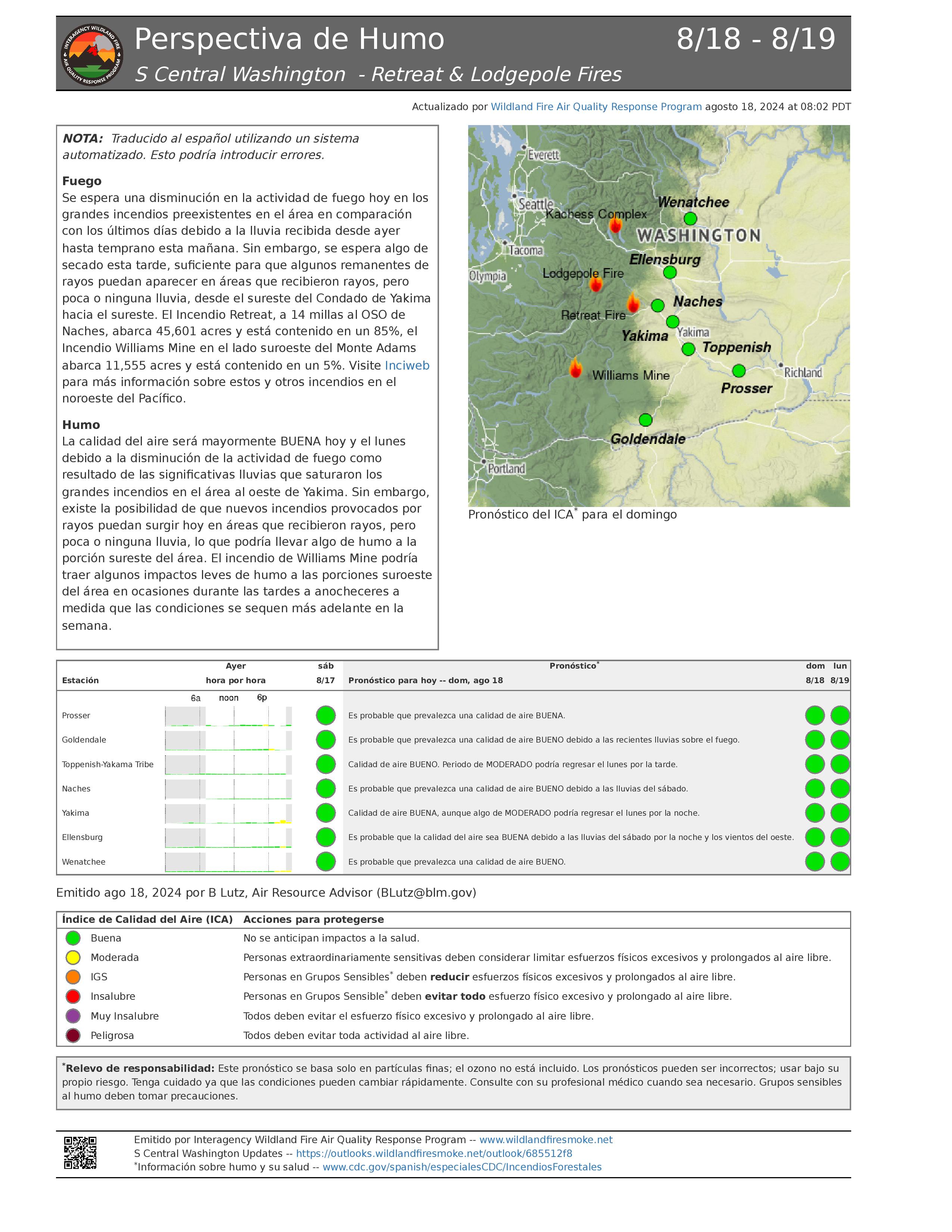
Información diaria del incendio de Lodgepole - 18 de agosto de 2024
Hectáreas: 35
Contención: 6%
Cantidad de personal: 28
Situación actual: El incendio Lodgepole está ubicado en el área de naturaleza Norse Peak Wilderness, al norte de la carretera 410 cerca del campamento Lodgepole Campground, que se encuentra dentro del Bosque Nacional Okanogan-Wenatchee.
Los bomberos y las topadoras han construido una línea de control entre el incendio y la carretera 410. Las cuadrillas instalaron mangueras y rociadores a lo largo de esta para asegurar que el fuego no se desplace aún más hacia el sur, y hacia la carretera 410. Una de las prioridades del incidente sigue siendo el proteger el corredor de la carretera y evitar que el incendio Lodgepole se propague hacia el sur. Los helicópteros siguen ayudando con la extinción mediante misiones de verter agua en los focos de calor más grandes de la zona del incendio. El fuego permanece generalmente ardiendo por el suelo, y la mayoría del calor resulta por la quema de grandes escombros caídos como resultado del fuego dentro de la huella del incendio Norse de 2017.
Debido al lugar donde se encuentra el incendio Lodgepole dentro del área de naturaleza difícil, además de la cantidad grandísima de grandes árboles en pie secos en toda el área quemada anteriormente, los bomberos tienen que ser estratégicos al construir líneas de control de manera segura. Los bomberos están planeando usar características de retención natural que les ayudarán a mantener el fuego hacia el este y el oeste. Hay varias cabinas en propiedad privada de vecindades de cabinas recreativas del Servicio Forestal, tanto al este como al sur del incendio. En los últimos días, los bomberos han neutralizado la vegetación alrededor de estas cabinas e instalado sistemas de rociadores por si el fuego llegar a acercarse a estas estructuras. Hoy, las cuadrillas inspeccionarán el área en búsqueda de problemas que crearon las tormentas eléctricas de anoche y el efecto que tuvieron en el incendio.
La última actualización de incidentes para el incendio Lodgepole se publicará el lunes 19 de agosto de 2024. El Equipo 14 interagencial de gestión de incidentes e California transferirá el mando del incidente al Bosque Nacional Okanogan-Wenatchee al final de su turno el lunes. Si llegara a haber algún cambio grande con el incendio Lodgepole, el Bosque Nacional Okanogan-Wenatchee compartirá la información pertinente en su sitio web y plataformas de redes sociales.
Clima: Anoche, las lluvias torrenciales cubrieron gran parte de la zona del incendio debido a que pasaron varias tormentas eléctricas. El día de hoy estará parcialmente soleado con temperaturas un poco más frescas (70-78 grados). Existe una posibilidad pequeña de chubascos esta mañana y la posibilidad de algunas nubes esta tarde. Se pronostican vientos ligeros todo el día. Esta noche los cielos estarán mayormente despejados de nuevo.
Cierres: El campamento Lodgepole Campground está cerrado actualmente, pero no existen otros cierres de bosques o campamentos como resultado del incendio Lodgepole.
La carretera 410 permanece abierta para viajar. Tome precauciones en el área debido a los efectos del humo, así como a los bomberos y equipos de emergencia que trabajan a lo largo de la carretera. Se recomienda a las personas que viajan que verifiquen la situación de la carretera en el sitio web del Departamento de Transporte del Estado de Washington en tinyurl.com/4ptbkfua.
Calidad del aire y humo: El pronóstico de la calidad del aire y las condiciones del humo se pueden ver en airnow.gov.
18 de agosto de 2024 Actualizacin diaria de los incendios Whisky Creek y Sandstone 08 18 2024
Related Incident: Whisky Creek FireSandstone Fire
Publication Type: News
Whisky Creek Tamaño: 1,973 acres | Fecha de inicio: 20 de julio | Causa: De orígen humano, a ser determinada | Contención 9% Sandstone Tamaño: 699 acres | Fecha de inicio: 5 de agosto | Causa: Rayo | Contención: 19% Personal total 663 | Equipos de obreros: 21 | Camiones de bombersos: 1 | Tanques de agua: 6 | Topadoras: 5 | Otras maquinarias pesadas: 14 | Helicópteros: 4
Aspectos destacados: Ayer por la tarde, llegó un sistema meteorológico grande al Cascade Mountain Range que resultó en 1/4 a 3/4" de lluvia, ráfagas de viento de hasta 50 mph y granizo sobre la zona de incendios. A pesar de la gran cantidad de lluvia, estos incendios siguen intensos. Los grandes troncos ardientes que mayormente son protegidos por el dosel del bosque, no se extinguen fácilmente con una tormenta pasajera. Como lo más importante es la seguridad de los trabajadores y debido a estas condiciones climáticas peligrosas, los bomberos suspendieron las operaciones a primeras horas de la tarde.
Operaciones: Sigue habiendo progreso en los incendios Whisky Creek, Sandstone y Blister Creek. Sin embargo, árboles debilitados por el fuego, escombros rodantes y el terreno escarpado dificultan el trabajo de extinción. Ya que el borde del incendio Blister Creek está rodeado por una línea de contención, los recursos se han ido a áreas de mayor prioridad en el incendio Sandstone que está cerca. Un pequeño grupo de personal seguirá vigilando el incendio Blister Creek en busca de cualquier calor cerca del perímetro. En Sandstone, las cuadrillas continúan evaluando las condiciones en busca de oportunidades para luchar conta el fuego de manera más directa mientras el clima favorece el área del incendio. Las cuadrillas de mano completaron de construír la línea en el extremo norte del incendio en Thunder Mountain Ridge. Los bomberos continúan explorando y construyendo líneas de contingencia a lo largo de los extremos oeste y este de los incendios.
En el incendio Whisky Creek, sigue mínima la intensidad del fuego. En los extremos sur y este del incendio, las cuadrillas trabajaron para neutralizar, derribar árboles peligrosos y fortalecer partes de la línea de contención. Mangueras y rociadores se han instalado en el incendio salpicado de Black Lake. Las cuadrillas de mano continuaron explorando la parte sureste del perímetro del incendio en busca de oportunidades para enfrentar el fuego de manera más directa y manera segura si las condiciones lo permiten. Las cuadrillas removerán escombros leñosos grandes a lo largo de Forest Road 630 y 2820, al este de Green Point Mountain.
Clima e intensidad del fuego: El día de hoy estará soleado y despejado con posibilidad de lluvia. La mayor humedad y las temperaturas más frías continuarán moderando la intensidad del fuego.
Seguridad: A pesar de las condiciones climáticas favorables que minimizan el peligro de nuevos incendios grandes, el riesgo sigue siendo grande. El público juega un papel importante en la prevención del próximo incendio forestal. Evite causar una presión excesiva sobre los recursos de extinción de incendios al tener cuidado con cualquier fuente de ignición. Para obtener consejos de prevención, visite, https://keeporegongreen.org. Hay restricciones contra incendios dentro del Bosque Nacional Mt. Hood. Se puede ver más información enhttps://www.fs.usda.gov/main/mthood/fire. Se ha establecido una restricción temporal de vuelo (TFR) en ambas áreas de incendio.
Humo: Se espera que la calidad del aire sea buena para ambas áreas de incendio. Para ver más información sobre las condiciones del humo en su área, visite: www.AirNow.gov.
Cierres: Información sobre el cierre del Bosque Nacional Mt. Hood y el Área Escénica Nacional del Río Columbia se puede encontrar en escaneando el código QR o siguiendo el enlace en la esquina inferior derecha de la página. La información sobre el cierre del condado River se puede encontrar en su sitio web: www.hoodrivercounty.gov/closures. Los cierres se implementarn para la seguridad del público y de los equipos de bomberos: El entrar en un área cerrada puede detener las actividades de extinción de incendios, lo que pone en peligro la vida y propiedad, y resultar en multas.
Para más información sobre los incendios de Whisky Creek y Sandstone, consulte los siguientes recursos:
Correo electrónico: 2024.whiskycreek@firenet.gov or 2024.sandstone.or@firenet.gov Teléfono: 541-208-1743, 8 a.m. – 8 p.m. Sitio web: Escanea el código QR a la derecha o vaya a https://linktr.ee/whisky_creek.2024
Actualizacin Matutina del Incendio Retreat 18 de Agosto 2024 08 18 2024
Related Incident: Retreat
Publication Type: News
Actualización Matutina del Incendio Retreat - 18 de Agosto 2024
Acres totales: 45.601 acres Contención: 85% Cantidad de personal: 317
Situación actual: Los bomberos siguen aumentando la contención en el incendio Retreat mediante operaciones diligentes de nuetralización y extinción. Las cuadrillas han estado patrullando el borde del incendio y asegurándose de que no queden fuentes de calor que pudieran amenazar la seguridad de las líneas de control. A medida que estas líneas de control se prueban y patrullan sin problemas, los bomberos toman la decisión de considerar como ya contenidas ciertas secciones.
El día de hoy, los bomberos continuarán patrullando las líneas de contención y extinguiendo cualquier foco de calor que queda, talarán árboles de peligro en el sistema de carreteras internas, removiendo los materiales (troncos y maleza) que quedaron cuando se preparó la línea divisorio de combustible a lo largo de las carreteras forestales 1200 y 1201, y removiendo el equipo innecesario y la manguera de incendios de la zona del incendio. Las cuadrillas inspeccionarán el área en busca de problemas creados por las tormentas eléctricas de anoche.
A las 8:00 a.m. del 17 de agosto de 2024El Departamento de Transporte del Estado de Washington abrió de nuevo la carretera US 12. Las personas que viajan, deben planificar tiempo adicional al viajar debido al tráfico de un solo carril y alternado en una sola dirección mientras los equipos de WSDOT y contratistas de emergencia trabajan para reemplazar las barandillas y las señales de carretera a lo largo de la carretera US 12 entre el poste la millas 185, cerca del cruce con la carretera 410 y el poste de millas 168, cerca de la intersección de Tieton Road. Se recuerda al público que aún siguen vigentes varios cierres debido al incendio en el área (consulte los Cierres por el incendio a continuación).
La última actualización de incidentes del incendio Retreat se publicará el lunes 19 de agosto de 2024. El Equipo 14 de gestión de incidentes interagenciales de California transferirá el mando del incidente a las agencias locales al final de su turno el lunes. Si hay algún cambio grande con el incendio Retiro, las agencias locales compartirán la información pertinente en su sitio web y plataformas de redes sociales.
Clima: Anoche, las lluvias torrenciales cubrieron gran parte del área del incendio debido a que pasaron varias tormentas eléctricas. El día de hoy estará parcialmente soleado con temperaturas un poco más frescas (70-78 grados). Existe una poca posibilidad de lluvia esta mañana y la posibilidad de algunas nubes por la tarde. Se pronostican vientos ligeros todo el día. Esta noche, volveremos a cielos mayormente despejados.
Evacuaciones: Se han levantado todas las órdenes de evacuación por el incendio Retreat a partir del 16 de agosto de 2024.
Cierres por el incendio:
- Cierre por el incendio Retreat en el Bosque Nacional Okanogan-Wenatchee (tinyurl.com/5ext5aec).
- La Región Sureste del Departamento de Recursos Naturales del Estado de Washington (DNR, por sus siglas en inglés) ha cerrado temporalmente parte del Bosque Estatal Ahtanum. El público puede ver la información más actualizada sobre el cierre en dnr.wa.gov/ahtanum.
- El Departamento de Pesca y Vida Silvestre de Washington ha cerrado la mayor parte del Área de Vida Silvestre de Oak Creek al público debido al incendio Retreat hasta el 23 de agosto de 2024. Puede ver más información en tinyurl.com/bdet7845.
Calidad del aire y humo: El pronóstico de la calidad del aire y las condiciones del humo se pueden ver en airnow.gov.
August 18 2024 Whisky Creek and Sandstone Fires Daily Update 08 18 2024
Related Incident: Whisky Creek FireSandstone Fire
Publication Type: News
Whisky Creek Size: 1,973 acres | Reported Date: July 20 | Cause: Human, Under Investigation | Containment: 9% Sandstone Size: 699 acres | Reported Date: August 5 | Cause: Lightning | Containment: 19% Total Personnel 663 | Hand Crews: 21 | Engines: 1 | Water Tenders: 6 | Dozers: 5 | Other Heavy Equipment: 14 | Helicopters: 4
Highlights: A significant weather system arrived in the Cascades yesterday afternoon bringing 1/4 - 3/4” of rain, wind gusts up to 50 mph and hail over the fire areas. Despite significant precipitation, these fires remain active. Large burning logs, often protected by the forest canopy, are not readily extinguished by a passing storm. Responder safety is paramount so with these hazardous weather conditions, firefighters suspended operations in the early afternoon.
Operations: Progress continues on the Whisky Creek, Sandstone and Blister Creek Fires. However, fire weakened trees, rolling debris and steep terrain hinder suppression efforts. With Blister Creek’s fire perimeter surrounded by containment line, resources have been shifted to areas of higher priority on the nearby Sandstone Fire. A small contingent of personnel will continue to monitor the Blister Creek Fire for any evidence of heat near the perimeter. On Sandstone, crews continue to assess site conditions for opportunities to engage the fire more directly while favorable weather is over the fire area. Hand crews have completed line construction on the northern edge of the fire on Thunder Mountain Ridge. Firefighters continue to scout and construct contingency lines along the west and east sides of the fires.
On the Whisky Creek Fire, fire behavior remains minimal. On the south and east edges of the fire, crews worked to mop up, fall danger trees and secure portions of the containment line. The Black Lake spot fire is plumbed with hose lines and sprinklers are installed. Hand crews continue to scout the southeast portion of the fire’s perimeter for opportunities to safely engage the fire more directly if conditions allow. Crews plan to remove large woody debris along Forest Road 630 and 2820, east of Green Point Mountain.
Weather and Fire Behavior: Today will be sunny and clear. Higher humidity and cooler temperatures will continue to moderate fire behavior.
Safety: Despite favorable weather conditions decreasing the danger of new large fires, the risk is still significant. The public plays an important role in preventing the next wildfire; use caution with all ignition sources. For prevention tips visit, https://keeporegongreen.org. Fire restrictions are in place within the Mt. Hood National Forest. More information can be found at https://www.fs.usda.gov/main/mthood/fire. A Temporary Flight Restriction (TFR) is in place over both fire areas.
Smoke: Air quality is expected to be good for both fire areas. For more information on smoke conditions in your area, go to www.AirNow.gov.
Closures: The Mount Hood National Forest and the Columbia River Gorge National Scenic Area closure information can be found by scanning the QR code or following the link in the bottom right corner of this page. Hood River County closure information can be found on their website: www.hoodrivercounty.gov/closures.
Closures are put into place for the safety of the public and fire crews; intrusion in a closure area can interrupt fire suppression activities, endanger lives and property, and can result in fines.
For further information about the Whisky Creek and Sandstone Fires, see the following resources:
Email: 2024.whiskycreek@firenet.gov or 2024.sandstone.or@firenet.gov Phone: 541-208-1743, 8 a.m. – 8 p.m. Web: Scan the QR code at right or go to https://linktr.ee/whisky_creek.2024
Easy Fire Update 08 18 2024
Related Incident: Easy Fire
Publication Type: News
Easy Fire Update
August 18, 2024
Quick Facts
Size: 2,130 acres (no IR)
Start Date: July 17, 2024
Location: 17 miles west of Mazama, WA
Containment: 29%
Personnel Assigned: 246
Cause: Lightning
Resources Assigned: 6 crews, 12 engines, 6 water tenders
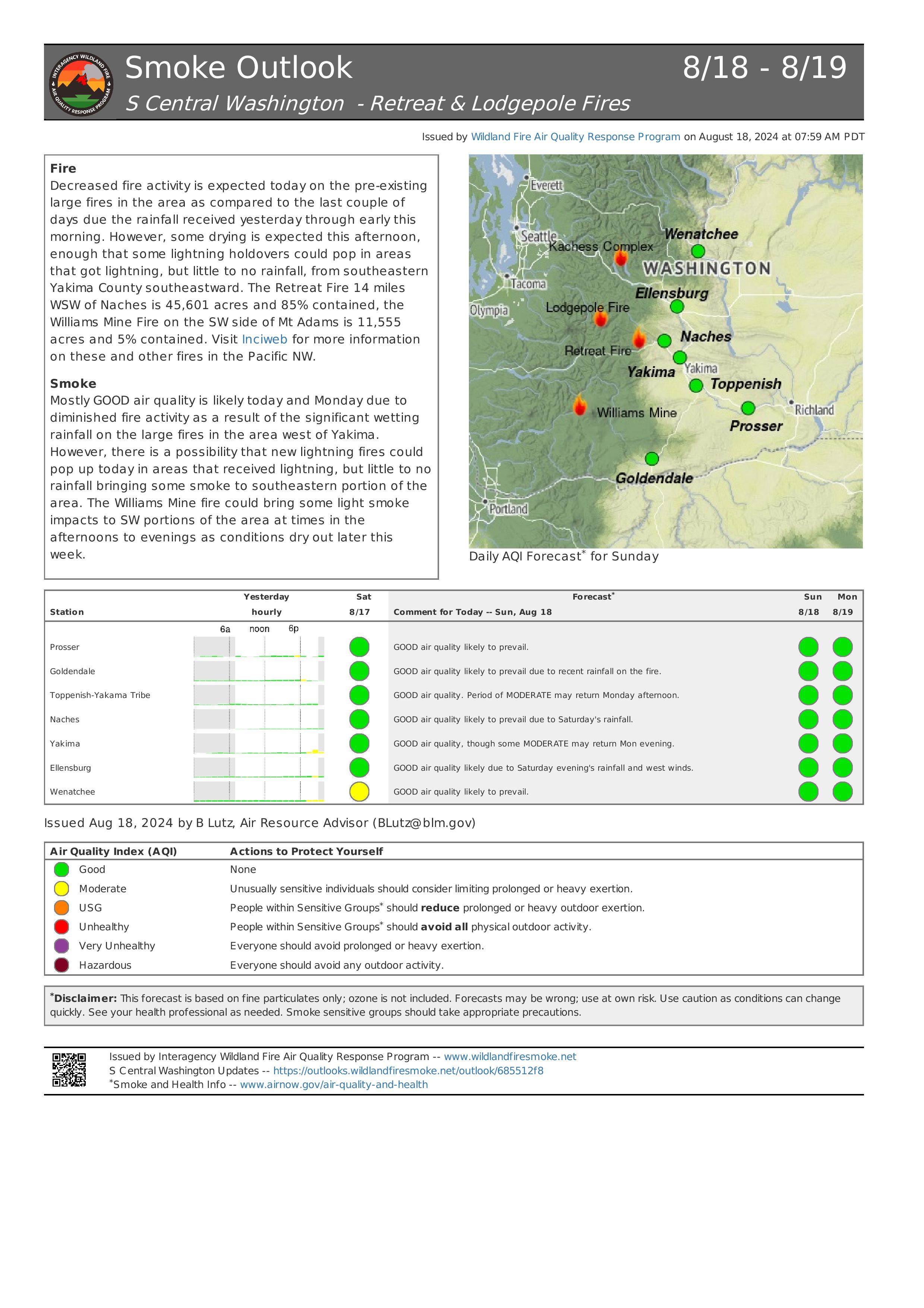
CURRENT SITUATION: The fire has been largely holding within its existing footprint in recent days. Yesterday firefighters utilized an unmanned aircraft system (UAS) equipped with infrared technology to detect any areas of the fire with remaining heat that might contribute to future fire spread. Helicopters dropped water on the fire to cool those hot spots. Firefighters on the ground assessed opportunities to work closer to the fire’s northern edge but were limited by high concentrations of snags, standing dead trees, which can fall and kill or injure firefighters working in the area. The fire is also burning on extremely steep slopes where burning logs can roll downhill, spreading the fire downslope and further threatening firefighter safety.
TODAY’S ACTIVITIES: Firefighters will continue to take opportunities to cool hot spots where possible given the steep terrain, potential for rollout, and abundant snags. Helicopters will support operations with strategic water drops where needed to remove heat from the fire’s edge and limit the potential for fire spread. Along the Highway 20 corridor, firefighters will continue to remove debris and mop up and secure the fireline.
WEATHER and SMOKE: Yesterday’s warmer and drier conditions were followed by overnight thunderstorms and rain over the fire area late in the evening and early morning hours. There is potential for additional thunderstorms this afternoon. A smoke outlook for the Pioneer and Easy Fires is available at:https://outlooks.airfire.org/outlook/f79a6d6d.
CLOSURES: Highway 20 is closed in both directions between Granite Creek (Mile Post 148) and Rainy Pass (Mile Post 157): Stay up to date at wsdot.com/Travel/Real-time/Map/
The Okanogan-Wenatchee National Forest has closures in place for trails within the fire area, for more information visit Okanogan-Wenatchee National Forest - Alerts & Closures (usda.gov). This closure includes a portion of the Pacific Crest Trail. Campfires are prohibited.
There is a Temporary Flight Restriction (TFR) in place over the fire: https://tfr.faa.gov/save_pages/detail_4_6779.html. Unauthorized drone activity is prohibited under the TFR.
EVACUATIONS: There are no evacuations in place for the Easy Fire. Anyone recreating in the area should be vigilant of surroundings and stay out of closed areas.
InciWeb: https://inciweb.wildfire.gov/incident-information/waowf-easy-fire
Facebook: https://www.facebook.com/profile.php?id=61560760893080
Fire Information Line: 541-861-5808, 8 AM to 8 PM
Email: 2024.easy@firenet.gov