
Middle Fork Complex Bull Trout Wapiti Fire Update Monday 08 19 2024
Related Incident: Bulltrout Fire
Publication Type: News
Incident Commander: Rick Connell, Northern Rockies Team 5
Middle Fork Complex Location: 9 miles east of Garden Valley, ID
Bull Trout Location: 15 miles WNW of Stanley, ID Wapiti Location: 2 miles southwest of Grandjean, ID
Start Dates: 07/24/24 – 08/06/2024
Cause: Lightning
Size:
Bull Trout: 271 acres Wapiti: 9,049 acres
Middle Fork Complex: Bulldog: 4,986 acres Nellie: 19,517 acres
Containment: Middle Fork Complex: 5% Wapiti: 10% Bull Trout: 92%
Resources on site:
Middle Fork Complex: 2 hotshot crews; 7 type 2 hand crews; 5 engines; 1 bulldozer; 1 water tenders
Wapiti: 2 type 1 hand crews; 1 type 2 hand crew; 16 engines; 2 water tenders; 1 skidgen, 1 bulldozer
Bull Trout: 1 engine
Total Personnel: Middle Fork Complex: 347 Wapiti: Bull Trout: 22
KEY MESSAGE:
Yesterday critical fire weather was observed however a red flag warning was not issued. Firefighters observed hot, dry windy conditions as the inversion lifted earlier in the day. Due to the heat and conditions, fires were active late into the night again and today conditions are predicted to remain the same and active fire behavior will continue.
Current Status/PLANNED ACTIONS:
Middle Fork Complex: The Middle Fork Complex is comprised of the Bulldog and Nellie fires.
Yesterday the Bulldog Fire actively grew to the north/northeast due to southwest winds. Firefighters were successful in suppressing a small spot fire between the river and the forest road 698 on the west side of the fire. The southern edge of the fire is holding due to crews working and improving the line as they work to the east along the fire’s edge. Weather conditions will be similar to the past two days and the fire is expected to grow to the northeast. The public is reminded that the Middlefork Road (FS Road 698) is closed at the Forest Service boundary just north of Lightning Creek and the Scriver Creek Road (FS Road 693) is also closed at the Forest Service Boundary for firefighter and public safety as crews continue to work to protect private property and structures in the vicinity of Crouch.
The Nellie Fire experienced active fire behavior and grew 3 miles to the north due to wind and terrain alignment. Firefighters reported that the Deadwood Lookout was not directly impacted by fire. Crews will continue point protection and planning infrastructure protection in the Deadwood Reservoir area and along the Highway 21 corridor. Air resources continue to support the fire when weather and air conditions permit. Smoke will remain visible as weather conditions remain hot and dry. The public is reminded that Forest Service Road #555 is closed at the intersection of Highway 17 all the way to the Forest Service Road #579 intersection.
Wapiti Fire: Yesterday, the Wapiti Fire experienced continued active fire behavior due to weather conditions, fuels and terrain. The fire crossed the river, and the alignment of slopes and winds allowed the fire to spread by group torching and long-range spotting to the north/northwest. Firefighters were able to assess structures that were impacted by fire during the red flag conditions on August 17th. Six structures were lost in the Wapiti Summer Home area. Crews are working 24 hours a day to secure the fire near structures and values at risk. Fixed wing aircraft and helicopters are being used to support the firefighters on the ground, but smoke can limit visibility and access for ariel resources at times. Smoke will impact the Highway 21 corridor and the public is reminded to always follow emergency responders’ instructions and drive safely.
Bull Trout Fire: The Bull Trout fire is still 92% contained, with little heat observed yesterday. An engine continues to patrol the fire daily to ensure no changes in activity.
Weather and Fire Behavior:
Yesterday critical weather conditions continued, and southwest winds continued with gusts on ridges up to 20 mph. Today elevated to near critical fire weather conditions can be expected again this afternoon. The morning inversion will lift early this afternoon and relative humidity will drop by 2 pm. Winds will remain terrain driven across most sheltered areas and south winds will spread across upper ridgelines and into aligned drainages during afternoon and early evening hours. Wapiti and Bulltrout fires may experience scattered showers thunderstorms in the afternoon today. Persistent hot, dry and breezy conditions continue to facilitate large fire growth potential. Group torching, spotting with wind and terrain influence fire movement in the afternoon and fire has been most active between 7pm and 9pm. Critical fire weather is expected to remain in place through Wednesday with changing cooler temperatures and higher relative humidity predicted Thursday and into the weekend.
CLOSURES, RESTRICTIONS, AND evacuations:
Middle Fork Complex: The Boise County Sheriff's Office continues to maintain the Level 2 evacuation notice for residents on and near the Middlefork Road between Stump Ranch Road up to Tie Creek Campground. The Boise National Forest issued an area closure for the fire (Closure #0402-06-59) effective August 12, 2024. The purpose of this order is to protect public safety during the fires.
Wapiti Fire: The evacuation order for Summer Homes and the Sawtooth Lodge remain in effect for the Wapiti Fire, as does the area closure issued by the Sawtooth and Boise National Forests (Closure #0402-05-94) effective August 12, 2024. This Order is for public and firefighter safety during fire suppression efforts of the Wapiti Fire.
Bull Trout Fire: The Bull Trout Fire Area Closure (Closure #0402-05-93) remains in effect for the roads and trails within the perimeter of the fire. The Boise National Forest issued this order on August,12, 2024. It will be rescinded as soon as it is safe to do so.
Closure information and maps are posted on the Forest’s website and the fire’s Inciweb page as they are in place. https://tinyurl.com/2u8v3pf7
The Boise National Forest, Idaho Department of Lands, and Bureau of Land Management are in Stage 1 fire restrictions on state, endowment, private and federal lands within the West Central Mountains Fire Restrictions Zone. For more information on the restrictions and a map visit:
https://www.idl.idaho.gov/fire-management/fire-restrictions-finder/
Middle Fork Complex Wapiti Bull Trout Daily Update 08 19 2024
Related Incident:
Publication Type: News
Incident Commander: Rick Connell, Northern Rockies Team 5
Middle Fork Complex Location: 9 miles east of Garden Valley, ID
Bull Trout Location: 15 miles WNW of Stanley, ID Wapiti Location: 2 miles southwest of Grandjean, ID
Start Dates: 07/24/24 – 08/06/2024
Cause: Lightning
Size:
Bull Trout: 271 acres Wapiti: 9,049 acres
Middle Fork Complex: Bulldog: 4,986 acres Nellie: 19,517 acres
Containment: Middle Fork Complex: 5% Wapiti: 10% Bull Trout: 92%
Resources on site:
Middle Fork Complex: 2 hotshot crews; 7 type 2 hand crews; 5 engines; 1 bulldozer; 1 water tenders
Wapiti: 2 type 1 hand crews; 1 type 2 hand crew; 16 engines; 2 water tenders; 1 skidgen, 1 bulldozer
Bull Trout: 1 engine
Total Personnel: Middle Fork Complex: 347 Wapiti: Bull Trout: 22
KEY MESSAGE:
Yesterday critical fire weather was observed however a red flag warning was not issued. Firefighters observed hot, dry windy conditions as the inversion lifted earlier in the day. Due to the heat and conditions, fires were active late into the night again and today conditions are predicted to remain the same and active fire behavior will continue.
CURRENT STATUS/PLANNED ACTIONS:
Middle Fork Complex: The Middle Fork Complex is comprised of the Bulldog and Nellie fires.
Yesterday the Bulldog Fire actively grew to the north/northeast due to southwest winds. Firefighters were successful in suppressing a small spot fire between the river and the forest road 698 on the west side of the fire. The southern edge of the fire is holding due to crews working and improving the line as they work to the east along the fire’s edge. Weather conditions will be similar to the past two days and the fire is expected to grow to the northeast. The public is reminded that the Middlefork Road (FS Road 698) is closed at the Forest Service boundary just north of Lightning Creek and the Scriver Creek Road (FS Road 693) is also closed at the Forest Service Boundary for firefighter and public safety as crews continue to work to protect private property and structures in the vicinity of Crouch.
The Nellie Fire experienced active fire behavior and grew 3 miles to the north due to wind and terrain alignment. Firefighters reported that the Deadwood Lookout was not directly impacted by fire. Crews will continue point protection and planning infrastructure protection in the Deadwood Reservoir area and along the Highway 21 corridor. Air resources continue to support the fire when weather and air conditions permit. Smoke will remain visible as weather conditions remain hot and dry. The public is reminded that Forest Service Road #555 is closed at the intersection of Highway 17 all the way to the Forest Service Road #579 intersection.
Wapiti Fire: Yesterday, the Wapiti Fire experienced continued active fire behavior due to weather conditions, fuels and terrain. The fire crossed the river, and the alignment of slopes and winds allowed the fire to spread by group torching and long-range spotting to the north/northwest. Firefighters were able to assess structures that were impacted by fire during the red flag conditions on August 17th. Six structures were lost in the Wapiti Summer Home area. Crews are working 24 hours a day to secure the fire near structures and values at risk. Fixed wing aircraft and helicopters are being used to support the firefighters on the ground, but smoke can limit visibility and access for aerial resources at times. Smoke will impact the Highway 21 corridor and the public is reminded to always follow emergency responders’ instructions and drive safely.
Bull Trout Fire: The Bull Trout fire is still 92% contained, with little heat observed yesterday. An engine continues to patrol the fire daily to ensure no changes in activity.
WEATHER AND FIRE BEHAVIOR:
Yesterday critical weather conditions continued, and southwest winds continued with gusts on ridges up to 20 mph. Today elevated to near critical fire weather conditions can be expected again this afternoon. The morning inversion will lift early this afternoon and relative humidity will drop by 2 pm. Winds will remain terrain driven across most sheltered areas and south winds will spread across upper ridgelines and into aligned drainages during afternoon and early evening hours. Wapiti and Bulltrout fires may experience scattered showers thunderstorms in the afternoon today. Persistent hot, dry and breezy conditions continue to facilitate large fire growth potential. Group torching, spotting with wind and terrain influence fire movement in the afternoon and fire has been most active between 7pm and 9pm. Critical fire weather is expected to remain in place through Wednesday with changing cooler temperatures and higher relative humidity predicted Thursday and into the weekend.
CLOSURES, RESTRICTIONS, AND EVACUATIONS:
Middle Fork Complex: The Boise County Sheriff's Office continues to maintain the Level 2 evacuation notice for residents on and near the Middlefork Road between Stump Ranch Road up to Tie Creek Campground. The Boise National Forest issued an area closure for the fire (Closure #0402-06-59) effective August 12, 2024. The purpose of this order is to protect public safety during the fires.
Wapiti Fire: The evacuation order for Summer Homes and the Sawtooth Lodge remain in effect for the Wapiti Fire, as does the area closure issued by the Sawtooth and Boise National Forests (Closure #0402-05-94) effective August 12, 2024. This Order is for public and firefighter safety during fire suppression efforts of the Wapiti Fire.
Bull Trout Fire: The Bull Trout Fire Area Closure (Closure #0402-05-93) remains in effect for the roads and trails within the perimeter of the fire. The Boise National Forest issued this order on August,12, 2024. It will be rescinded as soon as it is safe to do so.
Closure information and maps are posted on the Forest’s website and the fire’s Inciweb page as they are in place. https://tinyurl.com/2u8v3pf7
The Boise National Forest, Idaho Department of Lands, and Bureau of Land Management are in Stage 1 fire restrictions on state, endowment, private and federal lands within the West Central Mountains Fire Restrictions Zone. For more information on the restrictions and a map visit:
https://www.idl.idaho.gov/fire-management/fire-restrictions-finder/
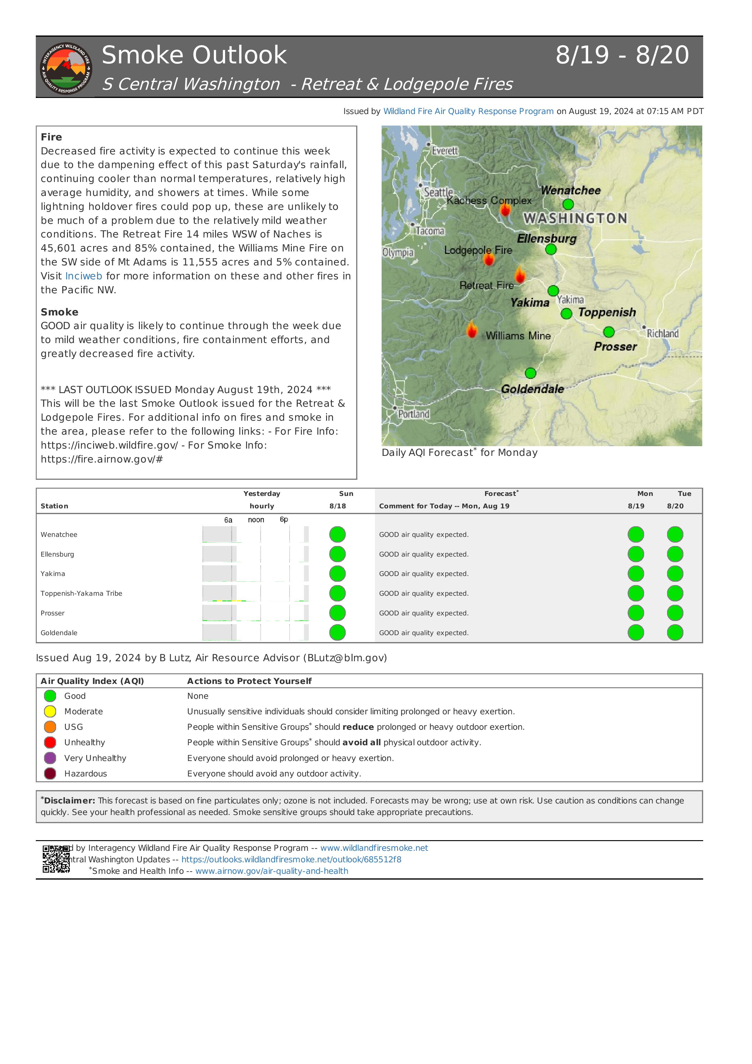
Retreat Fire Morning Update August 19 2024 08 19 2024
Related Incident: Retreat
Publication Type: News
Retreat Fire Morning Update - August 19, 2024
Total Acres: 45,601 acres Containment: 85% Total Personnel: 228
***This is the final Incident Update for the Retreat Fire***
California Interagency Incident Management Team 14 will transition command of the incident back to the local units at the end of shift today, August 19, 2024. If there are any significant changes regarding the Retreat Fire, the local units will share pertinent information on their websites and social media platforms.
Current Situation: Due to the diligent work of firefighters, the Retreat Fire has increased in containment and reached a status in which the local agencies can resume command of the incident with a minimal number of resources. The threat to the surrounding communities, utilities, and values at risk has been minimized to the point that all evacuation orders have been lifted and US 12 has been reopened.
Due to the fire effects of the Retreat Fire, several fire closures (see below) remain in effect until further notice. The local agencies will continue to have a small number of firefighters assigned to the incident to continue patrolling the area for any remaining hot spots and threats to public safety. These crews will ensure that containment lines continue to hold and that the remaining portion of the fireline is secured.
The public is reminded to be aware of firefighters and crews along the roadways when using US 12. Travelers should plan for added travel time due to single-lane, alternating one-way traffic as Washington State Department of Transportation and emergency contractor crews work to replace guardrail and highway signs along US 12 between mileposts 185, near the junction with State Route 410 and milepost 168, near the Tieton Road intersection.
Evacuations: All evacuation orders for the Retreat Fire have been lifted as of August 16, 2024.
Fire Closures:
- Okanogan-Wenatchee National Forest Retreat Fire Closure (tinyurl.com/5ext5aec).
- The Washington State Department of Natural Resources (DNR) Southeast Region has temporarily closed part of the Ahtanum State Forest. The public can access the most up-to-date closure information at dnr.wa.gov/ahtanum.
- Washington Department of Fish and Wildlife has closed the majority of the Oak Creek Wildlife Area to public access due to the Retreat Fire until August 23, 2024. More information can be found at tinyurl.com/bdet7845.
Air Quality and Smoke: Air quality and smoke condition outlooks can be found at airnow.gov.
Battle Mountain Complex Daily Update 08 19 2024
Related Incident: Battle Mountain Complex
Publication Type: News
New incident management team arrives today
Total Complex Estimated Acres: 183,026
Location: Ukiah, Oregon
Cause: Under Investigation
Personnel: 615
Containment: 94%
Estimated Cost: $79 million
Resources: 9 crews | 14 engines | 1 helicopter | 21 water tenders | 18 dozers
Operations: An incoming Type 3 management organization will arrive today. They will assume responsibility of the Battle Mountain Complex tomorrow. Today, the new fire management team will shadow the outgoing Southwest Area Incident Management Team to ensure a seamless transition. Tuesday, August 20, 2024 will be the final fire update from the Southwest Incident Management Team.
Equipment and crews continue building erosion control features on dozer and hand lines. Where available, cut brush is being dragged on top of firelines to prevent erosion and allow vegetation to regrow. As repair work is finished it is inspected by local agencies. North of the fire, equipment operators continue removing brush and trees along roads. The goal is still to leave areas fully repaired and follow through with the back-up firelines around Penland Lake that were started during the height of suppression.
As crews and equipment are leaving the incident, residents may see increased traffic over the next several days. Use caution when driving especially on blind curves where lowboy trailers may be traveling.
There is still high fire danger in the area. Fuels remain dry, and any new fire starts have the potential for rapid growth. Firefighters assigned to the Battle Mountain Complex are ready to respond to any new fires in the area, but residents should be aware of local fire restrictions.
Weather: Mostly sunny today with increasing clouds in the afternoon. Highs around 80 to around 90 with afternoon humidity 15-25%. West-southwest winds in the morning becoming west-northwest in
the afternoon 7-10 mph with gusts 15-25 mph.
Smoke: Smoke outlooks have stopped being issued for this fire. To view all currently issued Outlooks, go here: https://fire.airnow.gov/
Public Land Closures: Both the Bureau of Land Management and U.S. Forest Service have either rescinded or reduced closure orders for public lands. Visit https://linktr.ee/battlemntcomplex2024 for more information.
Road closures and fire restrictions: https://linktr.ee/battlemntcomplex2024
Grant, Morrow and Umatilla County Evacuations: https://linktr.ee/battlemntcomplex2024
Middle Fork Complex Wapiti Bull Trout Fire Update Monday 08 19 2024
Related Incident:
Publication Type: News
Incident Commander: Rick Connell, Northern Rockies Team 5
Middle Fork Complex Location: 9 miles east of Garden Valley, ID
Bull Trout Location: 15 miles WNW of Stanley, ID Wapiti Location: 2 miles southwest of Grandjean, ID
Start Dates: 07/24/24 – 08/06/2024
Cause: Lightning
Size:
Bull Trout: 271 acres Wapiti: 9,049 acres
Middle Fork Complex: Bulldog: 4,986 acres Nellie: 19,517 acres
Containment: Middle Fork Complex: 5% Wapiti: 10% Bull Trout: 92%
Resources on site:
Middle Fork Complex: 2 hotshot crews; 7 type 2 hand crews; 5 engines; 1 bulldozer; 1 water tenders
Wapiti: 2 type 1 hand crews; 1 type 2 hand crew; 16 engines; 2 water tenders; 1 skidgen, 1 bulldozer
Bull Trout: 1 engine
Total Personnel: Middle Fork Complex: 347 Wapiti: Bull Trout: 22
KEY MESSAGE:
Yesterday critical fire weather was observed however a red flag warning was not issued. Firefighters observed hot, dry windy conditions as the inversion lifted earlier in the day. Due to the heat and conditions, fires were active late into the night again and today conditions are predicted to remain the same and active fire behavior will continue.
Current Status/PLANNED ACTIONS:
Middle Fork Complex: The Middle Fork Complex is comprised of the Bulldog and Nellie fires.
Yesterday the Bulldog Fire actively grew to the north/northeast due to southwest winds. Firefighters were successful in suppressing a small spot fire between the river and the forest road 698 on the west side of the fire. The southern edge of the fire is holding due to crews working and improving the line as they work to the east along the fire’s edge. Weather conditions will be similar to the past two days and the fire is expected to grow to the northeast. The public is reminded that the Middlefork Road (FS Road 698) is closed at the Forest Service boundary just north of Lightning Creek and the Scriver Creek Road (FS Road 693) is also closed at the Forest Service Boundary for firefighter and public safety as crews continue to work to protect private property and structures in the vicinity of Crouch.
The Nellie Fire experienced active fire behavior and grew 3 miles to the north due to wind and terrain alignment. Firefighters reported that the Deadwood Lookout was not directly impacted by fire. Crews will continue point protection and planning infrastructure protection in the Deadwood Reservoir area and along the Highway 21 corridor. Air resources continue to support the fire when weather and air conditions permit. Smoke will remain visible as weather conditions remain hot and dry. The public is reminded that Forest Service Road #555 is closed at the intersection of Highway 17 all the way to the Forest Service Road #579 intersection.
Wapiti Fire: Yesterday, the Wapiti Fire experienced continued active fire behavior due to weather conditions, fuels and terrain. The fire crossed the river, and the alignment of slopes and winds allowed the fire to spread by group torching and long-range spotting to the north/northwest. Firefighters were able to assess structures that were impacted by fire during the red flag conditions on August 17th. Six structures were lost in the Wapiti Summer Home area. Crews are working 24 hours a day to secure the fire near structures and values at risk. Fixed wing aircraft and helicopters are being used to support the firefighters on the ground, but smoke can limit visibility and access for ariel resources at times. Smoke will impact the Highway 21 corridor and the public is reminded to always follow emergency responders’ instructions and drive safely.
Bull Trout Fire: The Bull Trout fire is still 92% contained, with little heat observed yesterday. An engine continues to patrol the fire daily to ensure no changes in activity.
Weather and Fire Behavior:
Yesterday critical weather conditions continued, and southwest winds continued with gusts on ridges up to 20 mph. Today elevated to near critical fire weather conditions can be expected again this afternoon. The morning inversion will lift early this afternoon and relative humidity will drop by 2 pm. Winds will remain terrain driven across most sheltered areas and south winds will spread across upper ridgelines and into aligned drainages during afternoon and early evening hours. Wapiti and Bulltrout fires may experience scattered showers thunderstorms in the afternoon today. Persistent hot, dry and breezy conditions continue to facilitate large fire growth potential. Group torching, spotting with wind and terrain influence fire movement in the afternoon and fire has been most active between 7pm and 9pm. Critical fire weather is expected to remain in place through Wednesday with changing cooler temperatures and higher relative humidity predicted Thursday and into the weekend.
CLOSURES, RESTRICTIONS, AND evacuations:
Middle Fork Complex: The Boise County Sheriff's Office continues to maintain the Level 2 evacuation notice for residents on and near the Middlefork Road between Stump Ranch Road up to Tie Creek Campground. The Boise National Forest issued an area closure for the fire (Closure #0402-06-59) effective August 12, 2024. The purpose of this order is to protect public safety during the fires.
Wapiti Fire: The evacuation order for Summer Homes and the Sawtooth Lodge remain in effect for the Wapiti Fire, as does the area closure issued by the Sawtooth and Boise National Forests (Closure #0402-05-94) effective August 12, 2024. This Order is for public and firefighter safety during fire suppression efforts of the Wapiti Fire.
Bull Trout Fire: The Bull Trout Fire Area Closure (Closure #0402-05-93) remains in effect for the roads and trails within the perimeter of the fire. The Boise National Forest issued this order on August,12, 2024. It will be rescinded as soon as it is safe to do so.
Closure information and maps are posted on the Forest’s website and the fire’s Inciweb page as they are in place. https://tinyurl.com/2u8v3pf7
The Boise National Forest, Idaho Department of Lands, and Bureau of Land Management are in Stage 1 fire restrictions on state, endowment, private and federal lands within the West Central Mountains Fire Restrictions Zone. For more information on the restrictions and a map visit:
https://www.idl.idaho.gov/fire-management/fire-restrictions-finder/
Ruby Fire Daily Update and Map 08 19 2024
Related Incident: Ruby Fire
Publication Type: News
Ruby Fire Update
August 19, 2024
Minnesota Incident Command System (MNICS) Incident Commander-Jeb Backe
Ruby Fire Quick Facts
Size: 902 acres
Location: North Cascades National Park, Ruby Mountain, Diablo, Washington
Containment: 0% Cause: Lightning/Natural
Start Date: August 9, 2024 Total Personnel: 94
Fire Information:
Inciweb: https://inciweb.wildfire.gov/incident-information/wancp-ruby-fire
Email: 2024.Ruby@firenet.gov
Facebook: https://www.facebook.com/people/Ruby-Fire/61563760546137
Phone: 1-360-208-8096
Current Status: Fire suppression efforts will continue today as safety permits; access is difficult due to steep terrain and hazards. Yesterday, light rain produced moist, cool conditions and cloud cover over the fire. Firefighters were able to move ahead with suppression efforts and reported moderate fire activity that included smoldering, backing and single tree torching. Smoke plumes from the Ruby Fire remain noticeable from public areas.
Planned Actions: Firefighters will continue to protect critical infrastructure, park campgrounds, trails, backcountry camps, and other resources in preparation for fire growth. The Ruby Fire is a full suppression fire, and firefighters are utilizing strategies and tactics that provide the highest likelihood for success, while mitigating risks to firefighters and the public. The main objectives are protecting human life, minimizing damage to values at risk, and limiting wildfire spread to the north and west.
Weather: Monday, partially sunny with highs near 76. Southerly winds 3 to 7 mph gusting to 10 mph. In the evening, partially cloudy with a 15% chance for rain. East winds 3 to 6 mph. Lows near 57. There is a risk of thunderstorms in the fire area for the rest of the week.
Closures: There are multiple closures in place for public safety. Colonial Creek South Campground and boat launch, Thunder Arm south of Diablo Lake, and State Route 20 east of the park from MP 148 and MP 157, are closed. For a full list of closures visit https://go.nps.gov/fireclosures.
Burning Restrictions: Campfires, the ignition of wood, briquettes, or any fuel in fire pits, fire pans and barbeque grills, are banned in all portions of North Cascades National Park Service Complex: North Cascades National Park, Ross Lake National Recreation Area, and Lake Chelan National Recreation Area.
Drone Restrictions: Drones can seriously impact the safety of firefighting efforts, and operating drones within North Cascades National Park is prohibited, except with prior written approval from the superintendent.
Cooperating Agencies & Tribes: National Park Service, Upper Skagit Indian Tribe, Seattle City Light, Whatcom County, Whatcom County Sheriff’s Office, Washington State Dept. of Transportation.
Smoke: U.S. Interagency Wildland Fire Air Quality Response Program - Overall air quality will be good today in upper Skagit Valley. https://outlooks.wildlandfiresmoke.net/outlook/f79a6d6d
If you would like to sign up for our daily updates, please send an email to: 2024.Ruby@firenet.gov
Homestead Complex Fire Update08 19 2024
Related Incident:
Publication Type: News
Homestead Complex Fire Update for Monday August 19, 2024
No Man, Salmon 33, Horse Heaven Creek, Bullpup, Fuller Lake, Reynold’s Butte, Lost Bucket
Start date: July 19, 2024 | Location: Northeast of Glide, Oregon | Total Personnel: 774
Total Homestead Complex Fire size: 5,832 acres | Cause: Lightning | Containment: 31%
Summary
Northern Rockies Team 6 took over management of the Homestead Complex Fire at 6 a.m. today. They will continue building on the successes of those before them. A Type 1 helicopter is expected to arrive today to assist with fire operations across all fires. The rain event on Saturday helped moderate fire growth and behavior. No active starts from the lightning that came through were detected yesterday.
No Man (1,940 acres) and Salmon 33 (254 ac.): Because the live fuel moisture was high yesterday, the probability of ignition was only about 30%. This meant that burning conditions were not conducive to extensive on-the-ground firing operations. Firefighters will assess where to most effectively utilize equipment and fuels groups around both fires today.
Horse Heaven Creek Fire (2,235 ac.): The fire continues to creep and smolder on the landscape. Operations will focus on strengthening firelines to slow fire spread and continue firing operations.
Bullpup Fire (462 ac.) and Fuller Lake Fire (397 ac.): Fire crews are constructing indirect fire line and conducting tactical fire operations to keep the fires within control lines along the 5850 and 300 Roads.
Reynolds Butte Fire (335 ac): Crews are backhauling some of the firefighting equipment. Backhauling is when equipment like pumps, sprinklers, and hose fittings are removed where no longer needed.
Lost Bucket Fire (34 ac.): 100% contained on July 29, 2024.
Weather: Today is anticipated to be warm and dry. Temperatures will be in the upper 60s with relative humidities in the 40s and 50s. Winds will generally be out of the west-northwest 6-10 mph with gusts up to 18 mph at the ridge tops.
Closures and Fire Restrictions
The Bureau of Land Management (BLM), Roseburg District, has issued a closure order for portions of BLM land which border the Umpqua National Forest Emergency Fire Closure north of Steamboat. The closure order can be viewed here: https://www.blm.gov/sites/default/files/docs/2024-07/orwa-fpo-rbg-072624.pdf.
The Umpqua National Forest has Emergency Fire Closures in place impacting every district of the forest. https://www.fs.usda.gov/alerts/umpqua/alerts-notices.
There is a Temporary Flight Restriction (TFR) over the Homestead Complex Fire. Please remember, if you fly we can’t! If a drone or other aircraft enters the air space, all firefighting aviation equipment will be grounded.
Fire Information Line: 541-208-7100 (Staffed 8 a.m. to 8 p.m.)
Email: 2024.homesteadcomplex@firenet.gov
Diamond Complex and Middle Fork Daily Update 08 19 2024
Related Incident: Middle Fork Fire
Publication Type: News
The Diamond Complex on the Umpqua National Forest consisted of 28 lightning-caused fires totaling approximately 10,984 acres, 38% contained. Twenty of the original 28 fires in the Diamond Complex are now 100 percent contained.
The Middle Fork Fire in the northwest corner of Crater Lake National Park is 5,222 acres and is 0% contained.
On Saturday August 17th there were two Initial Attack (IA) responses (Luke Fire and Twin Peaks) within the operational area. Initial Attack (IA) resources went direct, secured and conducted mop up.
OPERATIONS:
Middle Fork Fire:
(5,222 acres, 0% contained):
Today, crews will continue clearing vegetation along the 230 Road and at the North Entrance to Crater Lake National Park. On the southern side, crews will continue to look for areas of opportunity to limit spread and make trails more defensible to the south. The park remains open.
Diamond Complex Fires:
Pine Bench Fire (North of Hwy 138 near Dry Creek, 3,922 acres, 30% contained):
Hand and Dozers crews pushed into the lower portion to attack the flank. A spot fire in Slide Creek was discovered and quickly secured by the resources. Today’s priority will be to contain the movement into Medicine Creek and reinforce the Slide Creek area. Crews will also be improving the road system by removing vegetation from the west side, moving north.
Potter Fire (North of Hwy 138, two miles southeast of Potter Mountain, 3,320 acres, 6% contained):
On the north side, crews engaged directly on the flanks and reinforcing firelines with dozer operations. Additionally, crews will continue clearing vegetation along the 265 Road, and prep the roads to the east and to the west. On the south side crews will continue looking for opportunities for containment to protect infrastructure.
Trep Fire (About four miles south of Hwy 138, 543 acres, 0% contained):
Resources will continue to improve conditions along the northern perimeter. On the south side, mop up will continue and prevent spread to the east into the Bear Creek Drainage.
Other fires within the Diamond Complex:
Lost Fire (Northeast of Trep Fire, 64 acres, 0% contained):
Ooya Fire (North of Hwy 138, one mile northeast of Bird Point, 373 acres, 73% contained):
Crews will mop up and secure the remaining open line.
Lemolo Fire (North of Lemolo Lake on Bunker Hill, 1,246 acres, 100% contained):
Crews will continue to mop up and back-haul excess equipment.
Trail Fire (East of Hwy 138 on the west slope of Mt. Thielsen, 842 acres, 77% contained):
Crews will continue to mop up and secure the area.
Trap Fire (One mile south of Hwy 138 near Trap Mountain, 17 acres, 0% contained):
Loafer Fire (44 acres, 56% contained)
WEATHER AND FIRE BEHAVIOR:
Precipitation, cooler temperatures and higher humidity minimized fire behavior. Minimal fire spread, backing, creeping and smoldering was observed over the last 24 hours.
SMOKE OUTLOOK:
For the most up to date information, please visit fire.airnow.gov/
EVACUATIONS:
The Douglas County Sheriff’s Office has lifted evacuation orders for all areas except for east of the Pine Bench Fire, which remains at a Level 1: BE SET for a single residence east of the Potter Fire. For an interactive map of evacuations, visit the Douglas Co. Sheriff’s Office website: www.dcso.com/evacuations
FOREST CLOSURE:
The Umpqua National Forest has two closures in place impacting every district of the forest. Most of the Diamond Lake Ranger District is closed. Closure Orders and maps can be found here: www.fs.usda.gov/alerts/umpqua/alerts-notices.
Fire danger is set at VERY HIGH, and Public Use Restrictions Level 3 ORDER NO. 06-15-24-04 is in effect:https://www.fs.usda.gov/detail/umpqua/fire/?cid=FSEPRD937986
The Rogue River-Siskiyou National Forest has issued a closure for the area north and west of Crater Lake National Forest along Highway 230 south to the intersection with Highway 62. See the Closure Order and map at https://www.fs.usda.gov/alerts/rogue-siskiyou/alerts-notices.
PARK CLOSURE:
Crater Lake National Park has several closures in effect, closure orders and maps can be found at: https://www.nps.gov/crla/learn/news/crater-lake-temporarily-closes-north-entrance-for-the-middle-fork-fire.htm.
REMINDER: The Pacific Crest Trail from the Dutton Ridge Intersection to Hwy 138, Lightning Springs, Bald Crater Loop, Bert Creek, and Boundary Springs Trails (within the park) are closed. Hikers and bikers may not use the North Entrance Road to enter or leave Crater Lake National Park.
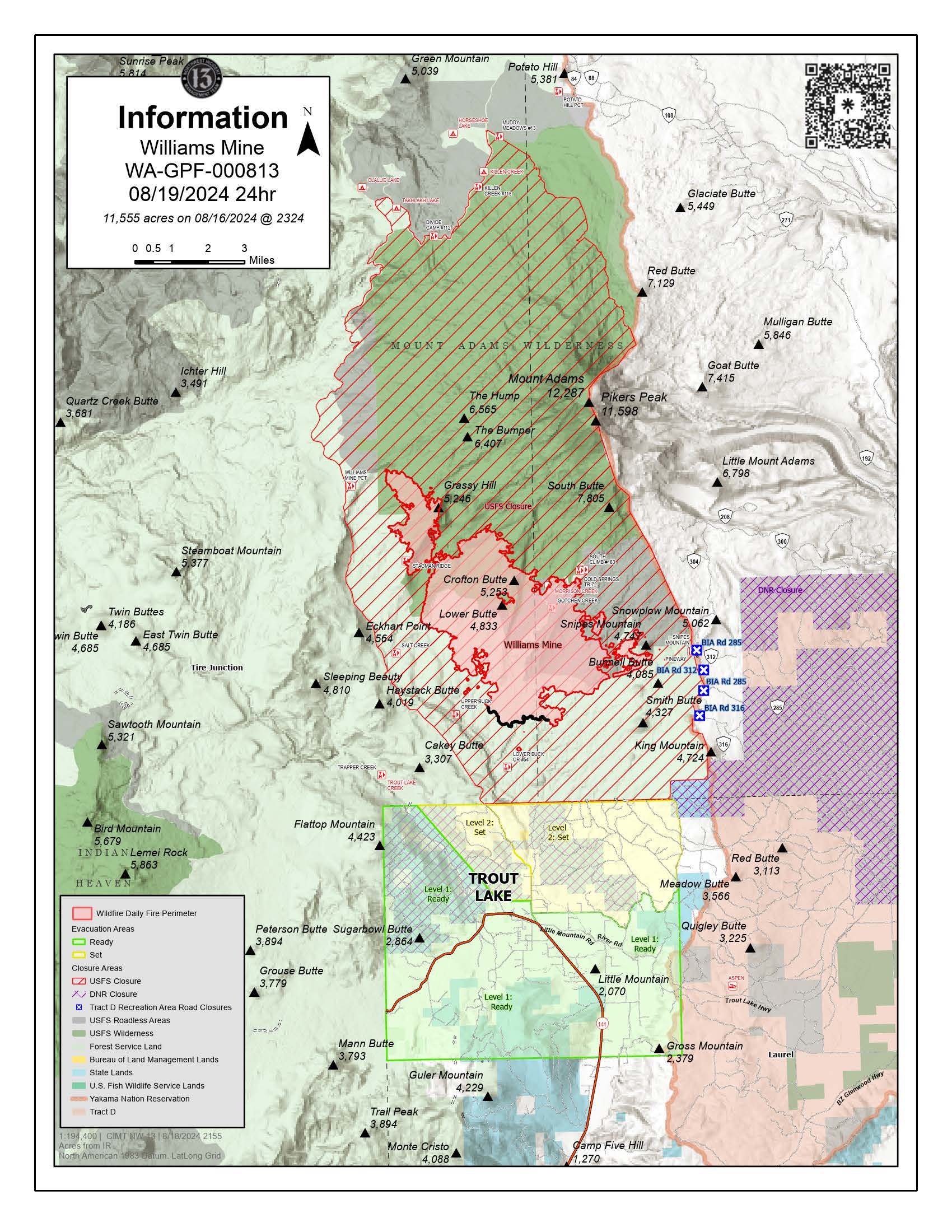
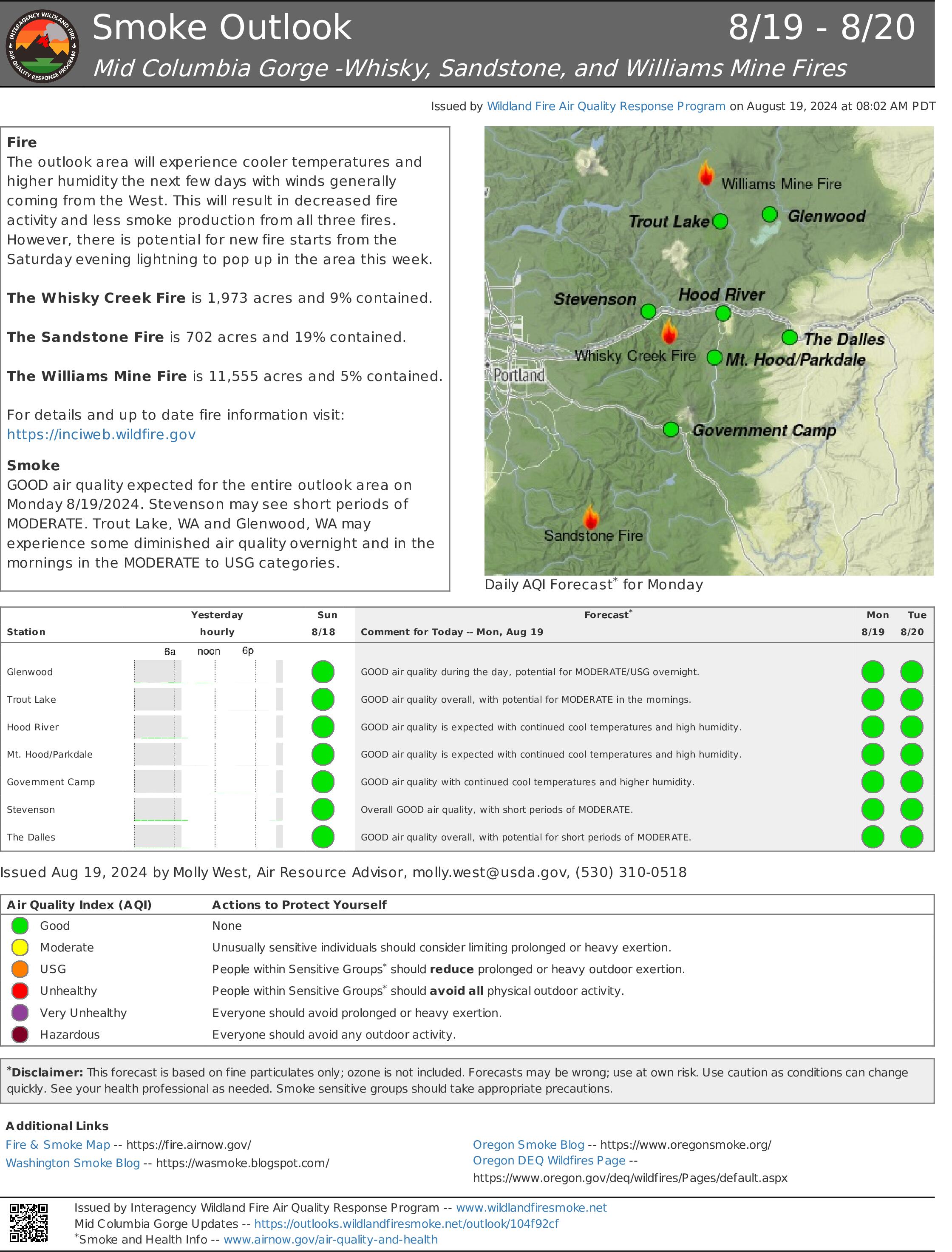
Williams Mine Fire Update 08 19 2024
Related Incident: Williams Mine Fire-GPNF
Publication Type: News
Williams Mine Fire Update for Monday, August 19, 2024
KEY MESSAGES:
Yesterday, crews returned to the fire area to assess impacts from Saturday night’s storm. Air operations re-engaged bucket drops around the fire perimeter and assisted with initial attack on new starts. Fire crews are utilizing infrared imagery with an unmanned aerial system to monitor the fire perimeter for spot fires or new starts due to the previous day’s lighting storm.
CURRENT STATUS:
South of the Williams Mine Trailhead and north of Eckhart Point, five lightning strikes were identified with at least one igniting a new fire. Air resources are on scene and crews responded to build containment lines around the new ignition. The initial size up had the new start smaller than ¼ acre. This new fire is known as the Dry Meadows Incident and is two miles west of the FS-23 road. Suppression efforts at this time have been successful.
Firefighters are completing mop up operations along the 051 road south of Snipes Mountain from the tactical burning completed at the end of last week. Crews are set up along the fire line and continue working deeper into the black, or burned area, to mop up remaining hot spots. Ground personnel will continue utilizing mechanized equipment on the FS-23 road, prepping the road as an alternate control feature if needed.
WEATHER / FIRE BEHAVIOR:
Today, cooler and calmer weather conditions will continue over the fire area as onshore flows will keep temperatures below seasonal averages and a marine layer will keep relative humidity values above 40%.
Due to the wetting rains Saturday, fire behavior will continue to be moderate around heavy fuels. Consumption of down and dead vegetation may take longer to burn, providing firefighters additional time to complete containment lines. There may be minimal but active behavior within the drip ring of live trees that did not get significant precipitation and may have the ability to re-ignite and carry fire spread.
SAFETY AND CLOSURES:
Washington DNR managed lands near Trout Lake and Glenwood are closed to entry due to the Williams Mine Fire. For more information, please see http://www.dnr.wa.gov/ahtanum. The Confederated Tribes and Bands of the Yakama Nation, Tract D Recreation Area is closed, please see Yakama Tract D Road Closure for more information. Level 1 & 2 evacuations are in effect for the community of Trout Lake, and parts of Klickitat County. Evacuations are coordinated through the Klickitat County Sheriff’s Office and the Skamania County Sheriff’s Office. The FS-23 and FS-25 roads are closed, see the Williams Mine Area and Road Closure for more details. The Pacific Crest Trail (PCT) is closed from the PCT's intersection with FS 23 to Potato Hill. The current area closure spans the entire Mt. Adams Wilderness.