
Red Fire Daily Update 08192024 08 19 2024
Related Incident: Red Fire
Publication Type: News
RED FIRE DAILY UPDATE
Monday, August 19, 2024
541-208-1766, 2024.red@firenet.gov https://inciweb.wildfire.gov/incident-information/ordef-red-fire
https://www.facebook.com/2024RedFireOR/
Size: 730 acres
Start Date: July 17, 2024 Cause: Lightning Containment: 0% Total Personnel: 152
Location: 5 miles west of Crescent Lake Junction, OR County: Klamath
Crescent, OR – The Red Fire is burning within the Diamond Peak Wilderness of the Deschutes National Forest, on the southwest slope of Redtop Mountain. The fire continues being managed under a full suppression strategy. Public and firefighter safety is the highest priority in managing this fire.
Yesterday’s Activities – The second phase of shaded fuel break work, the felling and processing of trees and brush, progressed along the Crescent Lake summer homes. Larger trees are being removed off-site for storage and truck activity remained heavy on the closed road areas.
Today’s Activities – This morning at 6 a.m. the Northern Rockies Incident Management Team 8 assumed command of the fire. They thanked the Southern Area ‘Gray’ Team for leaving behind a well-executed plan and foundation to build on. The Gray Team sends their appreciation to the crews and resources for excellent work, and thanks the La Pine community for their hospitality. Crews will inspect and finalize hose lays and sprinklers at structures adjacent to Crescent Lake. The felling and processing of trees with heavy equipment will continue on the shaded fuel break from Crescent Lake west to Summit Lake.
Weather and Smoke – Weather will continue to be favorable for fire suppression. Winds are expected to be around 7-10 mph out of the west with temperatures in the mid-60s, with fire activity limited to creeping and smoldering. Air quality information can be found at https://fire.airnow.gov/.
Closures – The Deschutes National Forest emergency closure around Crescent Lake and in Diamond Peak Wilderness is still in effect. The public should note that Forest Service Road 60 is closed, and road guards have been posted for public safety. More closure information is available at: https://www.fsa.gov/alerts/deschutes/alerts -notices/?aid=89091
Evacuations – The WILDFIRE! Level 1 – BE READY to Evacuate notice issued by Klamath County Emergency Management for Crescent Lake, Odell Lake, and Crescent Junction areas remains in effect (INCENDIO FORESTAL! Nivel 1 - ESTÉ PREPARADO para evacuar de las siguientes zonas: Crescent Lake, Odell Lake, Crescent Junction). Visit www.klamathcounty.org/300/emergency-management for more information or to sign up for alerts.
Fire Restrictions – Stage 2 Public Use Fire Restrictions – which prohibit open fires, including in developed campgrounds – remain in effect for the Deschutes National Forest. The Industrial Fire Precaution Level is currently Level IV “General Shutdown.” Visit fs.usda.gov/detail/deschutes/home/?cid=stelprdb5297376 for more information.
Drone Restrictions – Aerial firefighting is suspended when unauthorized drones (UAS) are in the area. Unauthorized drone use over a fire area poses serious risks to fire personnel and the effectiveness of wildfire suppression operations. If you fly, we can’t.
19 de agosto de 2024 Actualizacin diaria de los incendios Whisky Creek y Sandstone 08 19 2024
Related Incident: Whisky Creek FireSandstone Fire
Publication Type: News
Whisky Creek Tamaño: 2,057 acres | Fecha de inicio: 20 de julio | Causa: De orígen humano, a ser determinada | Contención 9% Sandstone Tamaño: 702 acres | Fecha de inicio: 5 de agosto | Causa: Rayo | Contención: 19% Recursos en total: 730 | Equipos de obreros: 24 | Camiones de bomberos: 9 | Topadoras: 5 | Otras maquinarias pesadas: 24 | Helicópteros: 4
(Odell, Oregón.) – El trabajo de extinción de incendios sigue en el incendio Whisky Creek, a 6 millas al sureste de Cascade Locks, Oregón, y en los incendios Sandstone y Blister Creek, a 9 millas al suroeste de Ripplebrook, Oregón. Los incendios arden en un terreno escarpado y accidentado en el Bosque Nacional Mount Hood, donde los escombros rodantes y los árboles debilitados por el fuego dificultan el trabajo de extinción. La prioridad principal sigue siendo la seguridad de los bomberos y del público. Los encargados de los incendios están aprovechando las condiciones climáticas buenas para evaluar y desarrollar planes para realizar esfuerzos más directos de extinción. A pesar de las lluvias grandes durante la tormenta del sábado, estos incendios siguen activos. Los grandes troncos en llamas y otros materiales caídos no se extinguen fácilmente on evento meteorológico pasajero.
Whisky Creek: Ayer, las cuadrillas se enfocaron en las áreas este y sureste del incendio. Las cuadrillas de mano justo al oeste de Rainy Lake, hacia el sur a lo largo de la montaña Green Point, neutralizaron los focos de calor persistentes. Cerca de allí, en la esquina sureste, completaron las líneas de contención alrededor de todos los fuegos salpicados y terminaron de remover árboles peligrosos. Los operadores de maquinaria pesada terminaron el trabajo a lo largo de los caminos forestales 630 y 650, mientras que sigue el trabajo de remover grandes escombros leñosos y de otro tipo a lo largo de los caminos forestales 2820, al este de la montaña Green Point.
Hoy, las cuadrillas reforzarán las líneas de mano en el extremo este del incendio y vigilarán los fuegos salpicados y contenidos cerca de Black Lake. Las cuadrillas de mano están explorando las partes sur del perímetro en búsqueda de oportunidades para limitar el tamaño de la huella del incendio. Los operadores de maquinaria pesada continuarán trabajando en las carreteras forestales 630 y 2820.
Sandstone y Blister Creek: Ayer, las cuadrillas que vigilaban el borde del incendio Blister Creek no vieron ningún crecimiento. Hacia el este, en el incendio Sandstone y a lo largo de la cresta empinada de Thunder Mountain, las cuadrillas de mano continuaron fortaleciendo la línea hasta Forest Road 4620, además de la esquina suroeste. Los operadores de maquinaria pesada prepararon las carreteras forestales 6320 y 7010.
Hoy, las cuadrillas fortalecerán las líneas de contención desde la cresta de Thunder Mountain hasta Forest Road 4620, que actuará como una línea de contingencia en el extremo noreste del incendio. Se comenzará a remover árboles peligrosos de las líneas de topadoras al suroeste del incendio. Las cuadrillas están colocando mangueras en el extremo sur y este del incendio a lo largo de los caminos de contención.
Clima y intensidad del fuego: Hoy, los cielos parcialmente nublados contribuirán a una mayor humedad y temperaturas más frescas, y condiciones más ligeras que resultarán en una intensidad moderado del fuego. Una baja probabilidad de lluvias dispersas durante la semana pudiera minimizar aún más la intensidad de los incendios.
El público juega un papel importante en la prevención del próximo incendio forestal. Evite causar una presión excesiva sobre los recursos de extinción de incendios al tener cuidado con cualquier fuente de ignición. Para obtener consejos de prevención, visite, https://keeporegongreen.org. Hay restricciones contra incendios dentro del Bosque Nacional Mt. Hood. Se puede ver más información enhttps://www.fs.usda.gov/main/mthood/fire. Se ha establecido una restricción temporal de vuelo (TFR) en ambas áreas de incendio.
Humo: Se espera que la calidad del aire sea buena para ambas áreas de incendio. Para ver más información sobre las condiciones del humo en su área, visite: www.AirNow.gov.
Cierres: Información sobre el cierre del Bosque Nacional Mt. Hood y el Área Escénica Nacional del Río Columbia se puede encontrar en escaneando el código QR o siguiendo el enlace en la esquina inferior derecha de la página. Los cierres se implementarn para la seguridad del público y de los equipos de bomberos.
Para más información sobre los incendios de Whisky Creek y Sandstone, consulte los siguientes recursos:
Correo electrónico: 2024.whiskycreek@firenet.gov or 2024.sandstone.or@firenet.gov Teléfono: 541-208-1743, 8 a.m. – 8 p.m. Sitio web: Escanea el código QR a la derecha o vaya a https://linktr.ee/whisky_creek.2024
Actualizacin Matutina del Incendio Retreat 19 de Agosto 2024 08 19 2024
Related Incident: Retreat
Publication Type: News
Actualización Matutina del Incendio Retreat - 19 de Agosto 2024
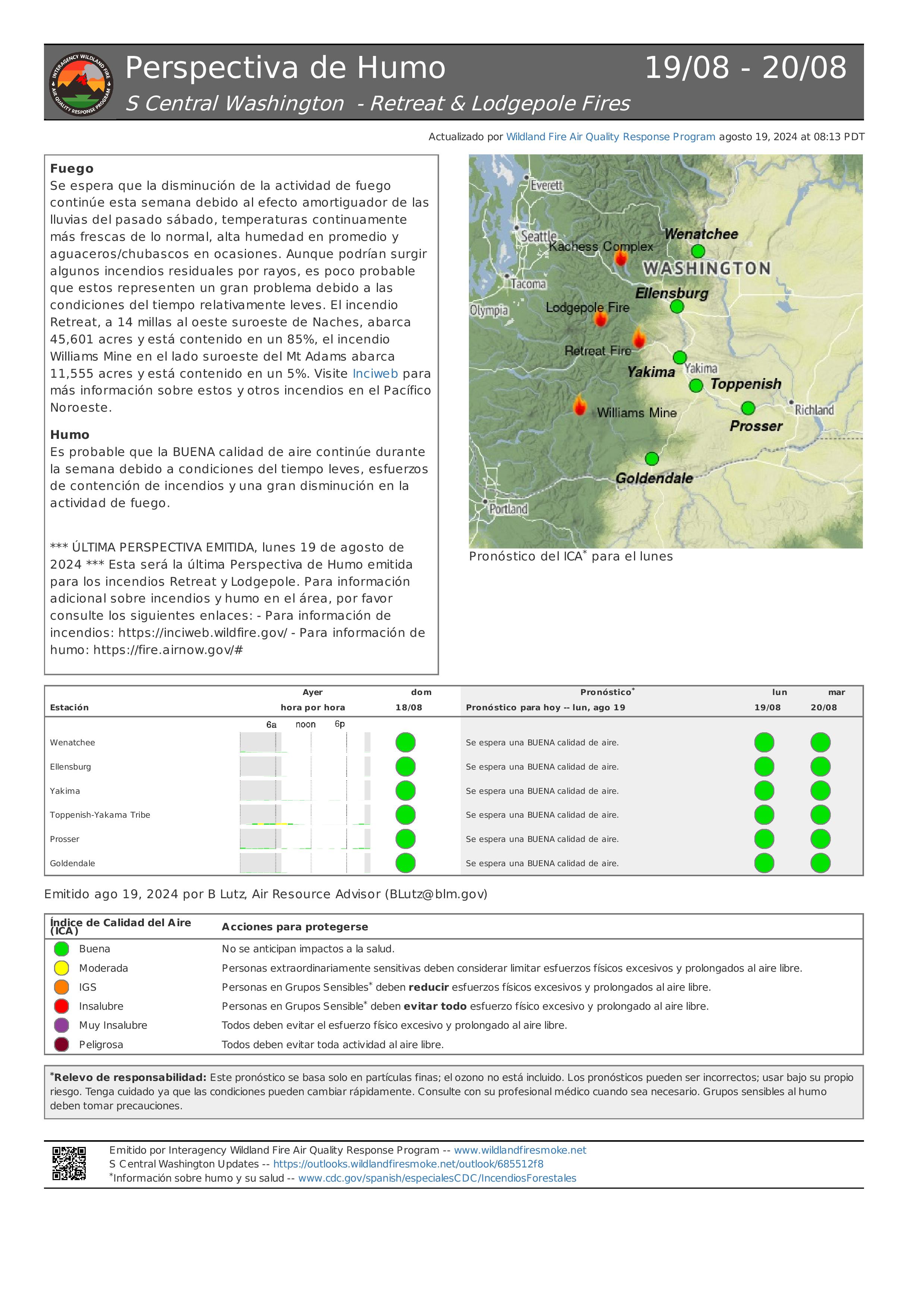
Acres totales: 45.601 acres Contención: 85% Cantidad de personal: 228
Esta es la última actualización de incidentes para el incendio Retreat
El Equipo 14 de gestión de incidentes interinstitucionales de California transferirá el mando del incidente a las agencias locales al final de su turno hoy, 19 de agosto de 2024. Si hay algún cambio importante con respecto al incendio Retreat, las agencias locales compartirán la información pertinente en sus sitios web y plataformas de redes sociales.
Situación actual: Debido al trabajo duro de los bomberos, ha aumentado la contención del incendio Retreat y ahora está un estado en el que las agencias locales pueden tomar el control de nuevo del incidente con un número mínimo de recursos. Se ha minimizado la amenaza a las comunidades alrededor, los servicios públicos y los valores en riesgo hasta el punto de que se han levantado todas las órdenes de evacuación y se ha abierto de nuevo la US 12.
Debido a los efectos del incendio Retreat, varios cierres de incendios (vea más abajo) permanecen en efecto hasta nuevo aviso. Las agencias locales continuarán con un número pequeño de bomberos asignados al incidente para que sigan patrullando el área en busca de focos de calor que queden y amenazas a la seguridad pública. Estas cuadrillas se asegurarán de que las líneas de contención continúen en su lugar y que siga bajo control la parte restante del cortafuegos.
Se recuerda al público que esté atento a los bomberos y equipos a lo largo de las carreteras cuando use la US 12. Las personas que viajan, deben planificar tiempo adicional al viajar debido al tráfico de un solo carril y alternado en una sola dirección mientras los equipos de WSDOT y contratistas de emergencia trabajan para reemplazar las barandillas y las señales de carretera a lo largo de la carretera US 12 entre el poste la millas 185, cerca del cruce con la carretera 410 y el poste de millas 168, cerca de la intersección de Tieton Road.
Clima: La baja presión continúa frente a la costa noroeste del Pacífico. Esto resultarán en algunas nubes, junto con algunas lluvias ligeras ocasionales y una poca probabilidad de tormentas eléctricas. Se esperan temperaturas más frescas y alta humedad por la tarde. Se prevé que los vientos del suroeste permanecerán ligeros esta mañana (1 a 5 mph) y luego cambien al noroeste (3-9 mph) con ráfagas de hasta 16 mph por la tarde. Se pronostica que la mayor probabilidad de tormentas eléctricas será el martes y el jueves.
Evacuaciones: Todas las órdenes de evacuación por el incendio Retreat se han levantado a partir del 16 de agosto de 2024.
Cierres por el incendio:
- Cierre por el incendio Retreat en el Bosque Nacional Okanogan-Wenatchee (tinyurl.com/5ext5aec).
- La Región Sureste del Departamento de Recursos Naturales del Estado de Washington (DNR, por sus siglas en inglés) ha cerrado temporalmente parte del Bosque Estatal Ahtanum. El público puede ver la información más actualizada sobre el cierre en dnr.wa.gov/ahtanum.
- El Departamento de Pesca y Vida Silvestre de Washington ha cerrado la mayor parte del Área de Vida Silvestre de Oak Creek al público debido al incendio Retreat hasta el 23 de agosto de 2024. Puede ver más información en tinyurl.com/bdet7845.
Calidad del aire y humo: El pronóstico de la calidad del aire y las condiciones del humo se pueden ver en airnow.gov.
Informacin diaria del incendio de Lodgepole 19 de agosto de 2024 08 19 2024
Related Incident: Lodgepole
Publication Type: News
Información diaria del incendio de Lodgepole - 19 de agosto de 2024
Hectáreas: 35
Contención: 6%
Cantidad de personal: 8
Esta es la última actualización de incidentes para el incendio Lodgepole
El Equipo 14 de gestión de incidentes interinstitucionales de California transferirá el mando del incidente al Distrito de Guardabosques de Naches del Bosque Nacional Okanogan-Wenatchee al final de su turno hoy, 19 de agosto de 2024. Si hay algún cambio importante con respecto al incendio Lodgepole, las agencias locales compartirán la información pertinente en sus sitios web y plataformas de redes sociales.
Situación actual: Debido al trabajo que han realizado los bomberos y las aeronaves y las lluvias torrenciales que hubo, el incendio Lodgepole ha alcanzado un estado en el que el Distrito de Guardabosques de Naches del Bosque Nacional Okanogan-Wenatchee puede asumir el mando del incidente con un número mínimo de recursos. La amenaza a las comunidades alrededor, los servicios públicos y los valores en riesgo se ha minimizado.
El incendio Lodgepole se ha minimizado a un paso ardiente sobre el suelo con la mayor parte del fuego dentro del interior del borde, donde quedan grandes materiales muertos y caídos por el incendio Norse Peak de 2017.
Los bomberos seguirán patrullando la línea de control entre el incendio y la carretera 410 y vigilarán el perímetro para detectar cualquier desplazo. El área del incendio está llena de muchos árboles muertos que son extremadamente peligrosos para los equipos que responden. Si es seguro participar, los bomberos construirán líneas de control directo en las áreas donde sean necesarias.
Clima: La baja presión continúa frente a la costa noroeste del Pacífico. Esto resultarán en algunas nubes, junto con algunas lluvias ligeras ocasionales y una poca probabilidad de tormentas eléctricas. Se esperan temperaturas más frescas y alta humedad por la tarde. Se prevé que los vientos del suroeste permanecerán ligeros esta mañana (1 a 5 mph) y luego cambien al noroeste (3-9 mph) con ráfagas de hasta 16 mph por la tarde. Se pronostica que la mayor probabilidad de tormentas eléctricas será el martes y el jueves.
Cierres: El campamento Lodgepole Campground está cerrado actualmente, pero no existen otros cierres de bosques o campamentos como resultado del incendio Lodgepole.
La carretera 410 permanece abierta para viajar. Tome precauciones en el área debido a los efectos del humo, así como a los bomberos y equipos de emergencia que trabajan a lo largo de la carretera. Se recomienda a las personas que viajan que verifiquen la situación de la carretera en el sitio web del Departamento de Transporte del Estado de Washington en tinyurl.com/4ptbkfua.
Calidad del aire y humo: El pronóstico de la calidad del aire y las condiciones del humo se pueden ver en airnow.gov.
August 19 2024 Whisky Creek and Sandstone Fires Daily Update 08 19 2024
Related Incident: Whisky Creek FireSandstone Fire
Publication Type: News
Whisky Creek Size: 2,057 acres | Reported Date: July 20 | Cause: Human, Under Investigation | Containment: 9% Sandstone Size: 702 acres | Reported Date: August 5 | Cause: Lightning | Containment: 19% Total Resources: 730 | Hand Crews: 24 | Engines: 9 | Dozers: 5 | Other Heavy Equipment: 24 | Helicopters: 4
(Odell, Ore.) -- Fire suppression efforts continue on the Whisky Creek Fire, 6 miles southeast of Cascade Locks, Ore. and the Sandstone and Blister Creek Fires, 9 miles southwest of Ripplebrook, Ore. The fires are burning in steep and rugged terrain on the Mt. Hood National Forest where rolling debris and fire-weakened trees challenge firefighting efforts. Firefighter and public safety remain the top priority. Fire managers are taking advantage of favorable weather conditions to assess and develop plans for more direct fire suppression efforts. Despite significant precipitation during Saturday’s storm, these fires remain active. Large burning logs and other downed materials are not readily extinguished by a passing weather event.
Whisky Creek: Yesterday, crews focused their efforts on the east and southeast areas of the fire. Just west of Rainy Lake, hand crews worked south along Green Point Mountain, mopping up lingering hot spots. Nearby, in the southeast corner, crews completed containment lines around all spot fires and finished removing hazardous trees. Heavy equipment operators completed work along Forest Roads 630 and 650. Crews continued with the removal of large woody material and other debris along Forest Road 2820, east of Green Point Mountain.
Today, crews will bolster hand lines on the east side of the fire and monitor contained spot fires near Black Lake. Hand crews are scouting the southern portions of the perimeter for opportunities to limit the size of the fire footprint. Heavy equipment operators will continue work on Forest Roads 630 and 2820.
Sandstone & Blister Creek: Yesterday, crews monitoring the Blister Creek Fire perimeter observed no growth. To the east on the Sandstone Fire along the steep Thunder Mountain ridgeline, hand crews continued securing line down to Forest Road 4620 as well as on the southwest corner. Heavy equipment operators worked on prepping Forest Roads 6320 and 7010.
Today, crews will strengthen containment lines from Thunder Mountain ridgeline to Forest Road 4620 which will act as a contingency line on the northeast side of the fire. Hazard tree removal on dozer lines to the southwest of the fire will begin. Crews are deploying hose lays on the south and east side of the fire along containment roads.
Weather and Fire Behavior: Today, partly cloudy skies will contribute to higher humidity and cooler temperatures, and otherwise mild conditions resulting in moderate fire behavior. A slight chance of scattered showers through the week may further reduce fire activity.
Safety: The public plays an important role in preventing the next wildfire; use caution with all ignition sources. For prevention tips visit, https://keeporegongreen.org. Fire restrictions are in place within the Mt. Hood National Forest. More information can be found at https://www.fs.usda.gov/main/mthood/fire. A Temporary Flight Restriction (TFR) is in place over both fire areas.
Smoke: Air quality is expected to be good for both fire areas. For more information on smoke conditions in your area, go to www.AirNow.gov.
Closures: The Mt. Hood National Forest, the Columbia River Gorge National Scenic Area and Hood River County closure information can be found by scanning the QR code or following the link in the bottom right corner of this page. Closures are in place for the safety of the public and fire crews.
For further information about the Whisky Creek and Sandstone Fires, see the following resources: Email: 2024.whiskycreek@firenet.gov or 2024.sandstone.or@firenet.gov Phone: 541-208-1743, 8 a.m. – 8 p.m. Web: Scan the QR code or go to https://linktr.ee/whisky_creek.2024
Media Update 81924 Dixon Fire 08 19 2024
Related Incident: Dixon Fire
Publication Type: News
Crews Shifting to Suppression Repair on Dixon Fire
DAYS CREEK, Ore. – While no fire growth has occurred for several days, crews on the Dixon Fire continue to find and douse hot spots to further secure the fire perimeter. In the northeast section of the fire, crews are combing through areas inside the perimeter and searching for any final heat as mop up nears completion. Along the northwest portion of the fire, where mop up has been largely completed, monitoring and patrol are underway.
Coffee Pot Fire Update 08 19 2024
Related Incident: Coffee Pot Fire
Publication Type: News
Fire Infromation: (559) 492-9988, Unit Hours: 9:00 AM to 5:00 PM
Location: West of Homers Nose on Salt Creek Ridge
Size: 869 acres, 0% contained, Personnel: 353, Cause: Lightning
CURRENT SITUATION: Yesterday, the fire continued to move down the slope in steep, rugged terrain. On the south flank, the fire moved about two-tenths of a mile and reached Bennett Creek and the Surprise Grove of Giant Sequoia. The fire is backing slowly through the grove and is being monitored by resource advisors. On the west flank, the fire only progressed about one-tenth of a mile.
Today, the priority continues to be building new indirect control lines on the south and west flanks around the fire's perimeter. On the west flank, hand crews are constructing an indirect control line from South Fork Drive to the north. On the south flank, they are constructing an indirect control line from Salt Creek Ridge to South Fork Drive, approximately one mile from the park boundary. The control lines are being constructed to keep the fire away from the community of Three Rivers. On the east flank of the fire, firefighters are looking at opportunities to create indirect handlines along the Lady Bug Trail. Firefighters can request water-dropping helicopters to cool any hot spots in the area.
WEATHER: Temperatures will rebound to near normal to slightly above through Wednesday, then cool Thursday through Saturday. The probability of thunderstorms remains near zero for the upcoming week. Winds will mainly be light with good overnight humidity recovery.
SMOKE IMPACTS: Smoke impacts are expected at night and in the morning, especially in the Mineral King and Giant Forest areas. You can check how wildfire smoke impacts your area at: AirNow.gov and fire.airnow.gov
ROAD AND TRAIL IMPACTS: Highway 198 and the Generals Highway in Sequoia and Kings Canyon National Parks are open. The Mineral King Road is also open. Park Superintendent Clay Jordan requests that visitors use caution while driving in the area to ensure the safety of firefighters working in the area.
BLM AND PARK CLOSURES: Portions of the South Fork Area in Sequoia and Kings National Parks are closed. You may view the closure information at: www.nps.gov/seki/learn/management/superintendent-s-compendium.htm. The Bureau of Land Management has also issued a closure of the Case Mountain Extensive Recreation Management Area.
PUBLIC NOTICE: Wildfires are a no-fly zone for unauthorized aircraft, including drones. If you fly, we can’t. For more information, visit https:/knowbeforeyoufly.org.
Lodgepole Fire Daily Update August 19 2024 08 19 2024
Related Incident: Lodgepole
Publication Type: News
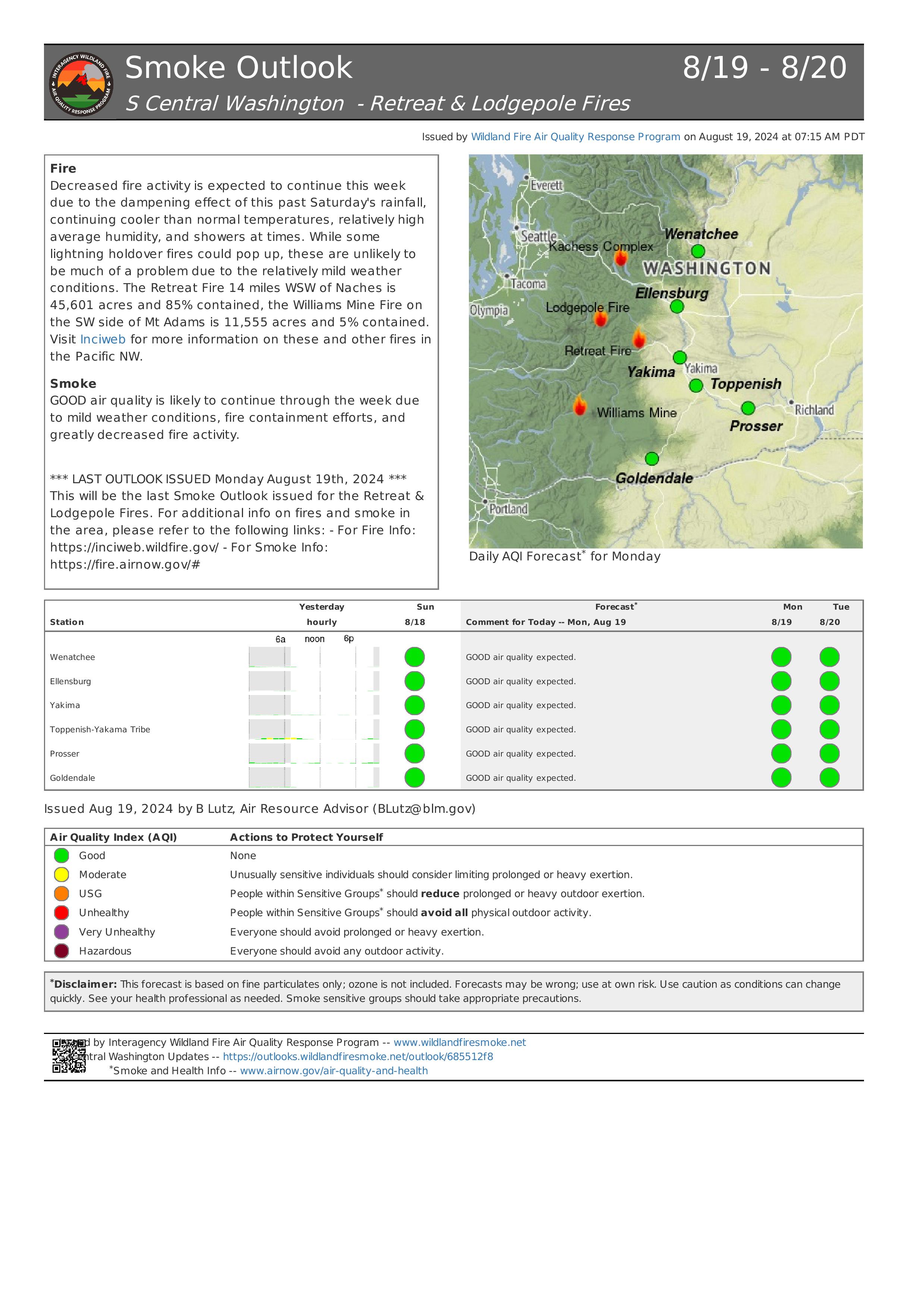
Lodgepole Fire Daily Update - August 19, 2024
Acres: 35
Containment: 6%
Total Personnel: 8
***This is the final Incident Update for the Lodgepole Fire***
California Interagency Incident Management Team 14 will transition command of the incident back to the Okanogan-Wenatchee Nation Forest – Naches Ranger District at the end of shift today, August 19, 2024. If there are any significant changes regarding the Lodgepole Fire, the local unit will share pertinent information on their websites and social media platforms.
Current Situation: Due to the work of firefighters, aircraft and wetting rains, the Lodgepole Fire has reached a status in which the Naches Ranger District of the Okanogan-Wenatchee National Forest can assume command of the incident with a minimal number of resources. The threat to the surrounding communities, utilities, and values at risk has been minimized.
The Lodgepole Fire has been reduced to a smoldering and creeping pace with a majority of the fire activity within the interior of the perimeter where large dead and down material remain from the 2017 Norse Peak Fire.
Firefighters will keep patrolling the control line between the fire and Highway 410 and monitor the perimeter for any movement. The fire area is filled with a large number of standing dead trees which are extremely dangerous for responding crews. If safe to engage, firefighters will construct direct control lines in areas where they are needed.
Weather: Low pressure continues off the Pacific Northwest coast. This will maintain some clouds, along with some occasional light showers and a slight chance of thunderstorms. Expected cooler afternoon temperatures and high afternoon humidity. Southwest winds are expected to remain light this morning (1 to 5 mph) then changing to northwest (3-9 mph) with gusts up to 16 mph in the afternoon. Highest probability of thunderstorms occurring is forecasted to be Tuesday and Thursday.
Closures: The Lodgepole Campground is currently Closed, but there are no other forest or campground closures due to the Lodgepole Fire.
Highway 410 remains open for travel. Please use caution in the area due to smoke impacts as well as firefighters and emergency equipment working along the highway. Travelers are encouraged to check the highway status through Washington State Department of Transportation website at tinyurl.com/4ptbkfua.
Air Quality and Smoke: Air quality and smoke condition outlooks can be found at airnow.gov.
Willamette Complex North Daily Update 08 19 2024
Related Incident: North Willamette Complex
Publication Type: News
Willamette Complex North
Ore & Pyramid Fires
Incident Update
Date: Monday, August 19, 2024
SPECIAL NOTE
State Route OR-126 will be closed for 48 hours from 7 a.m. 8/20 through 7 a.m. 8/22 for road repaving from mile marker 13 to 19.8. This will impact travel East of Belknap Springs. OR-20 and OR-58 are recommended as full detours around the closure; vehicles over 35 feet long are not allowed on OR-242.
CURRENT SITUATION
There has been no significant movement of either fire after recent thunderstorm activity. A general warming/drying is forecasted for the next couple of days. Temperatures will move gradually higher and humidities will drop gradually lower. Crews are taking advantage of wetter fuel conditions to secure containment lines. There are confirmed new lightning fires in the area, and incident resources are available to assist with fire responses as needed.
Ore Fire
Blue River, 3,132 Acres, 14% Contained, 567 Total Personnel, Human Caused
Overnight resources noted high fuel moistures with no threats to the lines. Fire activity will increase throughout the day as fuel conditions dry out with sun exposure. Crews will continue patrolling, mopping up, and completing contingency lines. Crews on the NW flank will look for opportunities to resume firing operations as conditions allow.
Pyramid Fire
East of Middle Santiam Wilderness, 1,320 Acres, 76% Contained, 283 Total Personnel, Lightning Caused
Potential for interior flare-ups and single tree torching will slowly increase throughout the day. Crews are continuing to mop up, patrol, and secure containment lines.
Weather & FIre Behavior
A gradually drying air mass will make conditions more consistent and terrain dependent across the fire area. Drying will most likely outpace warming as recent rain continues to have less influence. Winds are predicted at 3-6 mph in valleys and 8-12 mph on the ridgetops from the NW. Predicted maximum temperatures are 74-78° F in the valleys and 70-74°F on the ridgetops. Predicted minimum relative humidities are 40-46% in the valleys and 50-56% on the ridgetops.
For smoke and air quality conditions visit: AirNow.gov
Evacuations, Closures & Fire Restrictions
On July 17th, the Linn County Sheriff’s Office, in coordination with the Willamette National Forest, issued a Level 3: Go Now Evacuation Alert for the closure area affected. Please refer to the Linn County Fire Map tinyurl.com/LinnCoFireMap for full details of the issued evacuation area (which will appear in red). To sign up for evacuation alerts, visit linnsheriff.org/.
Area, road, trail, and recreation site closures are in effect in the Willamette National Forest.
Specific information is posted at https://www.fs.usda.gov/alerts/willamette/alerts-notices/?aid=61574.
Fire restrictions are in effect for Willamette National Forest. Read the complete restrictions at: https://www.fs.usda.gov/alerts/willamette/alerts-notices/?aid=81487.
Wildfires are a no-fly zone for unauthorized aircraft, including drones. If you fly, we can’t.
For more information, visit http://knowbeforeyoufly.org.
Boise Fire Update August 19 2024 08 19 2024
Related Incident: 2024 Boise Fire
Publication Type: News
Headlines
- There is traffic control planned along the Salmon River Road between Butler Flat and Nordheimer. Start date TBD.
- A public meeting is planned at the Forks of Salmon Community Club on August 20, 2024 at
5 p.m. This meeting will not be livestreamed. - Fire information phone: 707 572-4860 or email at 2024.Boise@firenet.gov
- Get all your Boise Fire information in one mobile-friendly place! https://linktr.ee/2024boisefiresrf
- Evacuations are in place for the Boise Fire for residents near the fire area in Humboldt County. For the most current evacuation information please visit the Boise Fire linktree or visit--
- Humboldt County: https://humboldtgov.org/356/Office-of-Emergency-Services
- Siskiyou County: https://www.co.siskiyou.ca.us/emergencyservices
Leader’s Intent: The Boise Fire is being managed with a full suppression strategy.
Operational Update: The fire showed little growth overnight, with conditions likely still moderated by wet weather. Today, crews spiked out on the Orleans Mountain Ridge will get to work early improving that line to establish containment to the north. Crews camped at Nordheimer Flat will again continue work to improve line and establish hose lays south from Echo Summit, while others will work their way north along the High Point Ridge opening up and improving existing dozer lines. Those two are expected to meet in the next few days, providing the primary containment line to the fire to the east. Crews are working directly along the fire’s active edge to the south on the northern edge of the Trinity Alps Wilderness to hold the fire there. They are looking to tie those lines into the Salmon Summit Trail to prevent fire from spreading to the east and south.
While this work is going on, firefighters are also looking at opportunities to work closer to the active edge of the fire on its east side, but they have not yet found a good opportunity in the steep, mainly roadless area. They are also assessing structures along the Salmon River and putting sprinklers, hoses, and pumps into place to protect infrastructure there should the fire overrun the primary proposed line.
Weather and Fire Behavior: The weather today is expected to be slightly warmer, with light diurnal winds in the afternoon. Fire behavior is expected to remain moderated by the weekend precipitation likely through the next few days.