
Homestead Complex Fire Update08 16 2024
Related Incident:
Publication Type: News
The Homestead Complex includes seven fires totaling 5,597 acres with an overall containment of 26%. There are 646 personnel currently working on the fire. Fire managers continue directing resources to fires based on threats to property, infrastructure, industry, and areas with the highest probability of success while providing for firefighter and public safety. The fire is being managed by Northwest Incident Management Team 8.
Yesterday, on the No Man Fire (1,899 acres), tactical burning operations were postponed due to conditions not being favorable for an effective burnout because of high nighttime relative humidity recovery, resulting in greater fuel moistures. Work continued with both mop-up operations and building contingency line on the 3806 and 3815 roads aimed at tying into control lines adjacent to the Salmon 33 Fire to the southeast. The Salmon 33 Fire (250 acres) remained within its footprint as firefighters strengthened control lines and mopped-up. Work continued on improving additional control lines that will tie into lines coming south from the No Man Fire. On the Horse Heaven Creek Fire (2,240 acres), the newly formed firing group (burnout specialists) that moved over from the No Man fire earlier in the day had good success conducting tactical burnouts down the eastern flank of the fire heading to the southeast corner. Fire managers scouted for opportunities to establish control lines around a “slopover” in the northwest corner of the fire near Horse Heaven Creek. Work continued on improving contingency control lines with heavy equipment along the 5850 road. Holding and mop-up operations continued along the southern flank. On the Bullpup Fire (456 ac.), additional dozer line was established off of the 200 Road and crews worked on handlines off of the 300 Road. Work also continued on improving contingency lines using the 300 Road and the 5850 Road. On the Fuller Lake Fire (383 acres), along the eastern flank of the fire, crews were engaged in holding the fire within control lines as it backed down and burned along the 5851 Road that is serving as a control line. Reynolds Butte Fire (335 acres) continued to show little activity and crews continued mopping up in that area.
Today, on the No Man and Salmon fires, the firing group will be looking for opportunities on the north and south flanks of No Man Fire to continue tactical burnouts. Work will also continue on prepping contingency lines on the 3806 and 3815 roads; this work is progressing east then south, with the objective of connecting into control lines along the Salmon 33 Fire. Holding and mop-up efforts continue on both fires.
On the Horse Heaven Creek Fire, fire managers will continue scouting for opportunities to establish control lines around the slopover in the northwest corner of the fire near Horse Heaven Creek. They will also be scouting for locations to establish additional direct, indirect and contingency control lines to the north. Work will continue on improving existing contingency lines with heavy equipment along the 5850 Road. Holding and mop-up operations will continue. Firefighters plan to continue with tactical burnouts progressing south toward the southeast corner of the fire, then continuing west to tie-in with existing control lines on the western flank of the fire. Firefighters assigned to the Bullpup and Fuller fires will continue working to keep the fires within the control lines along roads and dozer lines. Work will continue on improving control lines along the 300 and 200 road systems. Crews will continue patrolling and holding along the 5851 Road as the fire moves downslope and along the road. On the Reynolds Butte Fire, mop-up operations have made great progress to the point where the fire will likely be put in a patrol status in the near future requiring minimal staffing. This will allow other resources working the fire to be reallocated to more active fires on the complex. The Lost Bucket Fire (34 acres) was contained on July 29 and remains in a patrol status.
Today’s weather: Patchy clouds early, mostly clear skies in the afternoon. Smoke/haze will persist in the drainages and sheltered areas. Temperature highs in the mid-70s to 80s in the valleys, and upper 60s to mid-70s for upper elevations. Winds will be terrain driven in the morning, then changing to upper northwest winds 5 to 9 mph.
Current forest fire restrictions and danger ratings are-
Fire Danger Rating: Very High
Industrial Fire Precaution Levels (IFPL): 3
Public Use Fire Restrictions (PUR): 3
CLOSURES: The Bureau of Land Management (BLM), Roseburg District, has issued a closure order for portions of BLM land which border the Umpqua National Forest Emergency Fire Closure north of Steamboat. The closure order can be viewed here: https://www.blm.gov/sites/default/files/docs/2024-07/orwa-fpo-rbg-072624.pdf. The Umpqua National Forest has Emergency Fire Closures in place impacting every district of the forest. https://www.fs.usda.gov/alerts/umpqua/alerts-notices.
FIRE PREVENTION: Even with cooler weather, the vegetation is still dry and very susceptible to an unwanted fire start. Please continue to use extreme caution when recreating and working outdoors. 9 out of 10 wildfires nationally are started by a human, mostly all accidental. It only takes one spark!
Lodgepole Fire Daily Update August 16 2024 08 16 2024
Related Incident: Lodgepole
Publication Type: News
Lodgepole Fire Daily Update - August 16, 2024
Phone: 509-213-4890, 8 a.m. to 8 p.m.
Email: 2024.Lodgepole@firenet.gov
Fire Information: linktr.ee/CIIMT14
Acres: 35
Containment: 5%
Current Situation: The Lodgepole Fire is located in the Norse Peak Wilderness, north of Highway 410 near the Lodgepole Campground, located within the Okanogan-Wenatchee National Forest. The fire is burning within the burn scar of the 2017 Norse Fire which is filled with large amounts of dead and down debris as well as standing dead trees which are extremely hazardous to firefighters.
On Thursday, multiple helicopters were utilized for water dropping missions to slow the fire’s spread while firefighters on the ground worked to make progress through the dangerous terrain. Firefighters and heavy equipment have been constructing a control line between the fire and Highway 410. Protecting the highway corridor and preventing the Lodgepole Fire’s southern spread remains a top priority for the incident.
Due to the fire’s location in the steep and rugged wilderness as well as the enormity of large dead standing trees throughout the previous burn scar, firefighters are having to be strategic on where they can safely construct control lines. Firefighters have been looking to identify natural holding features that would assist them in containing the fire.
The fire remains a threat to multiple privately owned cabins in nearby Forest Service recreational residence cabin tracts both to the east and south of the fire. Crews are also continuing their work to prep the areas around threatened structures in the event the fire does move in their direction.
Weather: Increasing clouds over the fire area today. Windy conditions in the morning will subside, with winds coming from the west then north in the afternoon. Slight decrease in minimum humidity (33-39%) and slight increase in high temperatures (70’s) over the fire area compared to yesterday. Saturday afternoon and night a Flash Flood watch has been issued over the burn areas, with measurable amounts of rain expected.
Closures: The Lodgepole Campground is currently Closed, but there are no other forest or campground closures due to the Lodgepole Fire.
Highway 410 remains open for travel. Please use caution in the area due to smoke impacts as well as firefighters and emergency equipment working along the highway. Travelers are encouraged to check the highway status through Washington State Department of Transportation website at tinyurl.com/4ptbkfua.
Air Quality and Smoke: Air quality and smoke condition outlooks can be found at airnow.gov.

Black Canyon Fire Daily Update 08 16 2024
Related Incident:
Publication Type: News
Key Message
Fireline has been successfully established around the northern, middle, and southern fires, with no further fire growth observed. The current objectives are focused on holding, improving, and securing existing fire line, while maximizing firefighter and public safety. Yesterday, air operations delivered 16,000 pounds of essential equipment, including pumps, bladder bags, and water blivets containing 1,500 gallons of water, to the fire line. This equipment will support mop-up operations by providing accessible water sources for firefighting crews and engines.
Current Status
Yesterday, two DNRC Type 2 helicopters (UH-1H) delivered water blivets and hose to strategic locations on the northeastern fire line to aid in mop-up operations. Two large portable water tanks (6000 and 3000 gallons) were positioned at the base of Switchback Road for easy access and refilling by engines. A Type 1 Helicopter (Chinook) dropped water on hot spots and torching trees throughout the day to keep the fire within its perimeter. Crews started mop-up activities by plumbing much of the fire line with hoses and will continue these efforts today.
Today, crews are focused on securing the fire perimeter through continued mop-up activities. The Type 1 helicopter will be dropping water on hot spots, while crews will be working on holding and improving fire line by utilizing existing hose lays. Two skidgines will be shuttling water to refill the portable water tanks throughout the day. Heavy equipment will be used to rehabilitate previously constructed contingency lines.
Weather and Fire Behavior
Direct sunlight on the northeastern side of the fire in the morning has been preheating fuels, causing tree torching. Weather today will be partly sunny with temperatures ranging from 71-76 degrees with variable southwest winds up to 10 mph. Expect another round of showers and thunderstorms this afternoon with a better chance of wetting rain this evening.
Diamond Complex and Middle Fork Daily Update 08 16 2024
Related Incident: Middle Fork Fire
Publication Type: News
The Diamond Complex on the Umpqua National Forest consists of 28 lightning-caused fires totaling approximately 10,455 acres, with 832 people assigned. A new start was discovered recently. The Middle Fork Fire in the northwest corner of Crater Lake National Park has 38 people assigned, and the Diamond Complex is sharing resources as needed. The park remains open.
KEY MESSAGES: For public and firefighter safety, the North Entrance Road in the park is temporarily closed for firefighters to prepare control lines with machinery along that road. For details, visit https://www.nps.gov/crla/learn/news/crater-lake-temporarily-closes-north-entrance-for-the-middle-fork-fire.htm
Seventeen of the 28 fires in the Diamond Complex are now 100 percent contained.
OPERATIONS:
Middle Fork Fire (5,075 acres, 0% contained): The Wildland Fire Module cleaned up the southwest corner of the fire Thursday. Fuel reduction was completed along roads and trails on the west of the fire. After completion of prep along Hwy 230, many resources on the north flank were moved to smaller fires in the Diamond Complex. At the North Entrance to Crater Lake National Park, crews and equipment operators are slowly moving south along the North Entrance Road, clearing vegetation with a specialized machine called a “Spider”. A rubber-tired log loader will load log trucks to move wood out of the national park.
Cooler temperatures and high relative humidity kept the Middle Fork Fire fairly quiet on Thursday. Air resources, including helicopters for water bucket drops and reconnaissance flights and unmanned aircraft systems (UAS, or drones) for infrared imaging and firing operations remain available. The Pacific Crest Trail from the Dutton Ridge Intersection to Hwy 138, Lightning Springs, Bald Crater Loop, Bert Creek, and Boundary Springs Trails (within the park) are closed. Hikers may not use the North Entrance Road to enter or leave Crater Lake National Park.
Diamond Complex Fires
Pine Bench Fire (North of Hwy 138 near Dry Creek, 3,311 acres, 29% contained): Firefighters caught a spot in Slide Creek on the southeast edge of the fire yesterday and the fire was active around Camel Hump. Road preparation on the west side up Illahee Road is complete and the historic Illahee Lookout was wrapped for structure protection. The 3402 Road is currently being prepared as a control line, which involves fuel reduction and widening.
Potter Fire (North of Hwy 138, two miles southeast of Potter Mountain, 2,917 acres, 4% contained): Two hotshot crews caught a slopover on the northwest corner of the fire in the Nancy Creek drainage and are mopping up. A contingency line down a ridge to the east will be started with a dozer today, and line construction near Karen Creek will also begin.
Trep Fire (About four miles south of Hwy 138, 506 acres, 0% contained): Fire crews are improving dozer line on the south flank and are prepared to go direct where feasible.
Ooya Fire (North of Hwy 138, one mile northeast of Bird Point, 372 acres, 37% contained): Skidgines are supplying water to support the mop-up efforts. Masticating along the 2610 Road to the southwest past Bird Point will continue to create a contingency line.
Brodie Fire (Five miles south of Hwy 138, south of Devils Canyon, 217 acres, 57% contained): Firefighters are constructing direct handline on the northwest flank. Crews doing mop-up are being supported with water pumped from Skookum Lake.
Lemolo Fire (North of Lemolo Lake on Bunker Hill, 1,246 acres, 46% contained): Firefighters continue to cool the fire’s edge to secure the perimeter and more of the fire is contained every day. Backhaul of equipment is underway for redistribution to other fires in the complex.
Trail Fire (East of Hwy 138 on the west slope of Mt. Thielsen, 842 acres, 77% contained): Firefighters are mopping up in heavy duff and securing the eastern edge into the Mount Thielsen Wilderness. A helicopter will sling in a blivet (soft-sided water tank) today as a water source to support mop-up.
Lost Fire (Northeast of Trep Fire, 63 acres, 0% contained): The 4800 Road is being prepped and opened for mastication to create a fuel break and contingency control line.
Trap Fire (One mile south of Hwy 138 near Trap Mountain, 17 acres, 0% contained): Crews are constructing fuel breaks along existing roads in the Bear Creek Canyon as a contingency line for this group of fires.
Other fires within the Diamond Complex:
Loafer Fire (43 acres, 56% contained)
Bear Trap (65 acres, 100% contained)
Watson Fire (237 acres, 100% contained)
Maple Fire (.2 acres, containment unknown)
WEATHER AND FIRE BEHAVIOR: There may be some instability and showers in the area on Friday, but not necessarily measurable precipitation. Fire behavior will be limited to creeping, backing and flanking.
SMOKE OUTLOOK: Smoke has returned to the area and may reduce visibility and hinder air operations. For the most up to date information, please visit fire.airnow.gov/
CLOSURES, RESTRICTIONS, EVACUATIONS: The Umpqua National Forest has a closure in place affecting the Diamond Lake Ranger District. Most of the Diamond Lake Ranger District is closed. Closure Orders and maps can be found here: www.fs.usda.gov/alerts/umpqua/alerts-notices. Fire danger is set at VERY HIGH, and Public Use Restrictions Level 3 ORDER NO. 06-15-24-04 is in effect: https://tinyurl.com/PublicUseRestrictions
The Rogue River-Siskiyou National Forest has issued a closure for the area north and west of Crater Lake National Forest along Highway 230 south to the intersection with Highway 62. See the Closure Order and map at https://bit.ly/RRSNFAlerts
The Douglas County Sheriff’s Office evacuation order for the Trail Fire west of Hwy 138 is set at Level 1: Get Ready and east of Hwy 138 is set at Level 3: GO NOW. The evacuation order for the Lemolo Fire south of Lemolo Lake is set at Level 1: Be Ready and northeast of Lemolo Lake is set at Level 3: GO NOW. There is now a Level 1: BE SET for the Pine Bench Fire from Slide Creek to Soda Springs area. There is a Level 2: BE SET for the Potter Fire. For an interactive map of evacuations, visit the Douglas Co. Sheriff’s Office website: www.dcso.com/evacuations
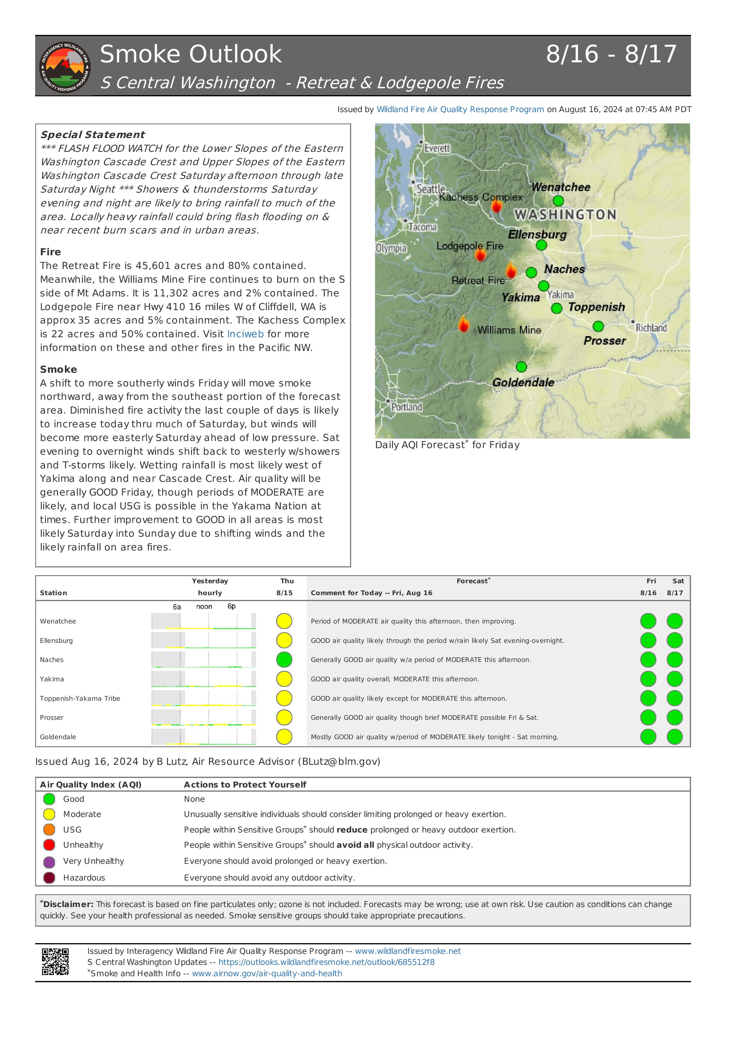
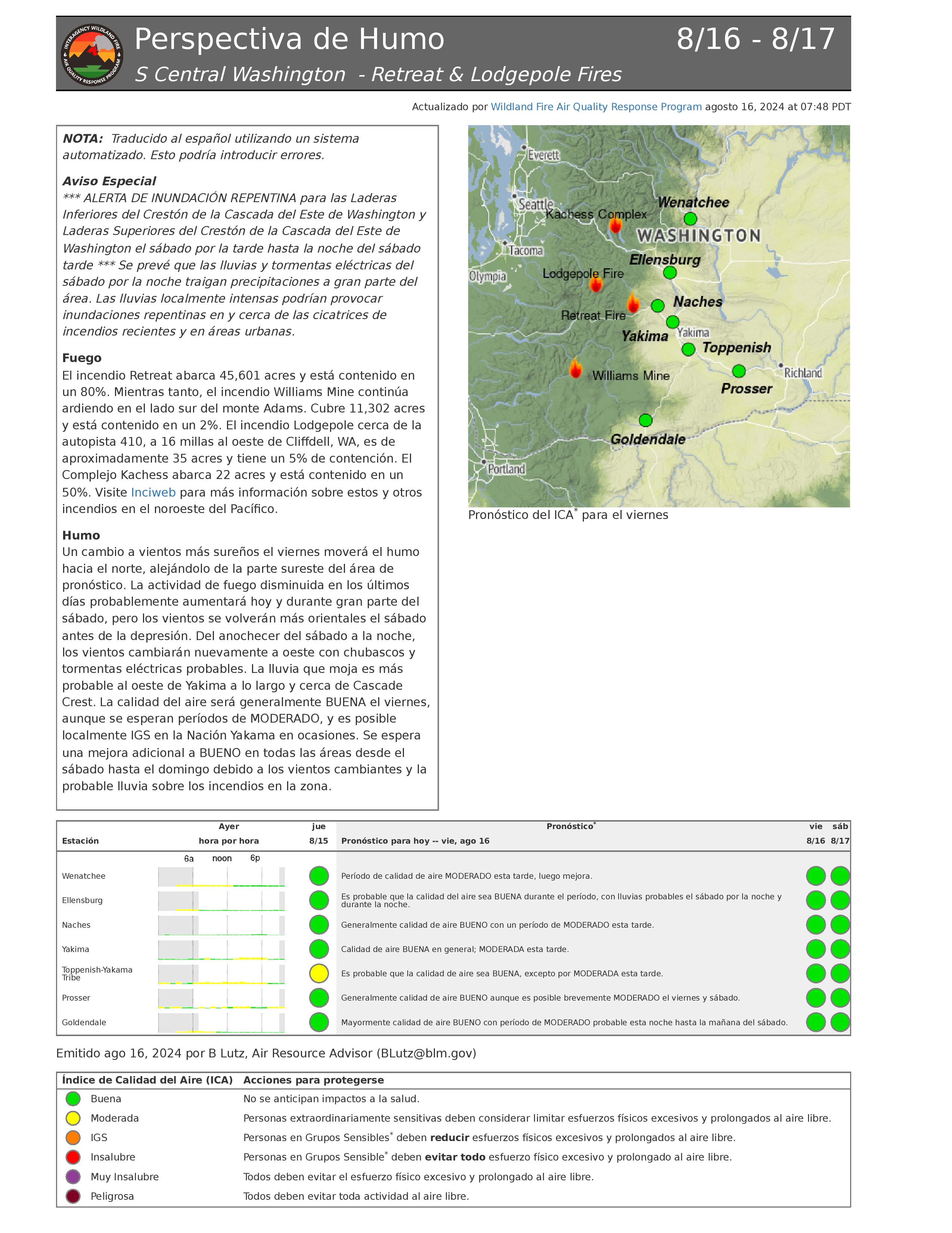
Retreat Fire Morning Update August 16 2024 08 16 2024
Related Incident: Retreat
Publication Type: News
Retreat Fire Morning Update - August 16, 2024
Phone: 509-213-4890, 8 a.m. to 8 p.m.
Email: 2024.Retreat@firenet.gov
Fire Information: linktr.ee/CIIMT14
Total Acres: 45,601 acres Containment: 80% Total Personnel: 335
Current Situation: All evacuation orders for the Retreat Fire have been lifted as of 8:00 a.m. today per Yakima County Emergency Management. Residents will be allowed through the Highway 12 road closure to access their property with proper proof of residency.
Firefighters have observed very little active fire across the fire area. Today they will patrol along containment lines extinguishing any hot spots they find, fall hazard trees along internal road systems to provide for safer access across the fire, remove materials (logs and brush) left from preparing the shaded fuel break along Forest Roads 1200 and 1201, and remove unneeded equipment and fire hose from the fireline.
Washington Department of Transportation crews along State Highway 12 continue working to replace guard rails and signs damaged by the fire, as this highway remains a top priority to reopen to public travel. Other utility work repair will also be active along Highway 12.
The control objective for the Retreat Fire is to keep the fire contained within the natural and constructed control features while prioritizing public and firefighter safety.
Weather: Increasing clouds over the fire area today. Windy conditions in the morning will subside, with winds coming from the west then north in the afternoon. Slight decrease in minimum humidity (33-39%) and slight increase in high temperatures (70’s) over the fire area compared to yesterday. Saturday afternoon and night a Flash Flood watch has been issued over the burn areas, with measurable amounts of rain expected.
Evacuations: According to Yakima County Emergency Management, all evacuation orders for the Retreat Fire have been lifted as of 8:00 a.m. today. Residents will be allowed through the Highway 12 road closure to access their property with proper proof of residency. For more information, visit yakimacounty.us/350. Residents are encouraged to drive slowly as highway workers, heavy equipment, and firefighters continue to be present along Highway 12
Fire Closures:
- US Highway 12 remains closed between the Y at Highway 410 and the summit of the pass at milepost 151.
- Okanogan-Wenatchee National Forest Retreat Fire Closure (tinyurl.com/5ext5aec).
- The Washington State Department of Natural Resources (DNR) Southeast Region has temporarily closed part of the Ahtanum State Forest. The public can access the most up-to-date closure information at dnr.wa.gov/ahtanum.
- Washington Department of Fish and Wildlife has closed the majority of the Oak Creek Wildlife Area to public access due to the Retreat Fire until August 23, 2024. More information can be found at tinyurl.com/bdet7845.
Air Quality and Smoke: Air quality and smoke condition outlooks can be found at airnow.gov.
Pioneer Fire Update 08 16 2024
Related Incident:
Publication Type: News
Pioneer Fire Daily Update
August 16, 2024
Quick Facts
Size: 38,721 acres
Start Date: June 8, 2024
Location: 31 miles NW of Chelan, WA
Containment: 23%
Personnel: 664
Cause: Under investigation
Resources Assigned: 7 crews, 6 helicopters, 21 engines, 26 water tenders, 13 heavy equipment
Command of the Pioneer, Easy, and Flat Creek Fires was transferred to Northwest Incident Management Team 3 at 6:00 a.m. today.
CURRENT SITUATION: The Pioneer Fire is burning on the steep forested slopes above the Stehekin Valley where firefighters are actively engaged in activities to protect homes and infrastructure and limit fire spread. Yesterday firefighters continued constructing direct handline, as close to the fire’s edge as possible, between Boulder and Rainbow Creeks to the ridgetop retardant line. Helicopters supported suppression activities with strategically placed water and retardant drops to cool hotspots and strengthen the barrier to fire spread created by the constructed fireline and retardant line. The fire continues to hold in the Boulder Creek drainage below the fireline. South of the fire and west of Manson, crews continued contingency line preparations.
TODAY’S ACTIVITIES: In the Boulder Creek area firefighters will continue direct handline construction to stop the northern progression of the fire. Aerial resources will continue to drop water and fire retardant in strategic locations in the Boulder Creek area. In Stehekin, firefighters will continue checking pumps and ensuring structure protection measures remain in place, where needed. Crews will continue to patrol the lakeshore and monitor the southern edge of the fire for any areas of heat. South of the fire crews are working to complete contingency line preparations using chippers and heavy equipment to clear slash and other debris from line preparation activities. Firefighters also remain ready to respond to any new fire starts.
WEATHER and SMOKE: Increased moisture and potential for afternoon showers are forecast for today. There is also a chance of developing thunderstorms today and Saturday which brings the potential for gusty outflow winds, heavy rain, and isolated to scattered lightning strikes throughout the fire area.
A smoke outlook for the Pioneer and Easy Fires is available at https://outlooks.airfire.org/outlook/f79a6d6d.
EVACUATIONS: Level 1, 2 and 3 evacuation levels remain in effect around the Pioneer Fire. Please visit https://t.ly/QoH9w for more information.
FOREST CLOSURE: Current closures for the North Cascades National Park: https://www.nps.gov/noca/index.htm
The Okanogan-Wenatchee National Forest has a closure order in place for much of the fire area: Okanogan-Wenatchee National Forest - Alerts & Closures (usda.gov). Campfires are prohibited. There is a Temporary Flight Restriction (TFR) in place over the fire: https://tfr.faa.gov/save_pages/detail_4_6779.html. Unauthorized drone activity is prohibited under the TFR.
InciWeb: https://inciweb.wildfire.gov/incident-information/wases-pioneer
Facebook: https://www.facebook.com/profile.php?id=61560760893080
Fire Information Line: 541-861-5808, 8 a.m. to 8 p.m.
Email: 2024.pioneer@firenet.gov
Willamette Complex North Daily Update 08 16 2024
Related Incident: North Willamette Complex
Publication Type: News
SPECIAL NOTE
There will be a community meeting for the Willamette Complex North tomorrow—Saturday, August 17th at 11 a.m. The meeting will take place at the McKenzie High School (new gym) located at 51187 Blue River Dr, Finn Rock, OR 97488.
CURRENT SITUATION
Warmer, drier conditions, and thinning smoke is expected to contribute to an increase in fire behavior today. As fire crews time out and travel home for much-needed rest and recovery, replacement crews and equipment continue to arrive.
Ore Fire
Blue River, 2,945 Acres, 12% Contained, 206 Total Personnel, Cause Under Investigation
Yesterday, crews continued patrol and mop up across all divisions, as well as suppression of a spot fire on the northern flank. Night crews observed minimal activity on the southern perimeter and conducted burnout operations to add depth to existing containment lines in the north. Infrared flights continue to show pockets of intense and scattered heat. Today, crews will evaluate opportunities to conduct burnout operations along the northern flank of the fire—with the goal of inhibiting fire growth beyond the 1509 and 827 Roads. Crews and heavy equipment across the Ore Fire will continue to prepare secondary lines, patrol the fire perimeter, suppress flare-ups or hot spots, and secure threats to the line by removing trees, snags, and other fuels.
Pyramid Fire
East of Middle Santiam Wilderness, 1,323 Acres, 73% Contained, 243 Total Personnel, Lightning Caused
Pockets of intense and scattered heat continue to be identified in the interior of the Pyramid Fire by infrared technology. Crews and heavy equipment continue to hold and improve fire lines, patrol the fire perimeter, and conduct mop up.
Weather & Fire Behavior
Much warmer and drier conditions are expected compared to yesterday, with a trough helping to thin smoke early in the morning. Predicted maximum temperature is 78 to 82 °F in the valleys and 74 to 78 °F on the ridgetops. Predicted minimum relative humidity is 38 to 44% in the valleys and 44 to 50% on the ridgetops. Weather conditions are expected to contribute to an increase in fire behavior. For smoke and air quality conditions visit: AirNow.gov
Evacuations, Closures & Fire Restrictions
On July 17th, the Linn County Sheriff’s Office, in coordination with the Willamette National Forest, issued a Level 3: Go Now Evacuation Alert for the closure area affected. Please refer to the Linn County Fire Map tinyurl.com/LinnCoFireMap for full details of the issued evacuation area (which will appear in red). To sign up for evacuation alerts, visit linnsheriff.org/.
Area, road, trail, and recreation site closures are in effect in the Willamette National Forest.
Specific information is posted at https://www.fs.usda.gov/alerts/willamette/alerts-notices/?aid=61574.
Fire restrictions are in effect for Willamette National Forest. Read the complete restrictions at: https://www.fs.usda.gov/alerts/willamette/alerts-notices/?aid=81487.
Wildfires are a no-fly zone for unauthorized aircraft, including drones. If you fly, we can’t.
For more information, visit http://knowbeforeyoufly.org.
Cottage GroveLane 1 Fire Update 08 16 2024
Related Incident: Lane 1 Fire
Publication Type: News
Firefighters continue mopping up into interior, work to secure perimeter
COTTAGE GROVE, Ore. – Containment for the Cottage Grove – Lane 1 Fires has increased to 37%. As firefighters work to mop up around the fire containment will continue to increase. Gridding for mop up and searching for areas of heat that could rekindle can be a tedious task and requires attention to detail and deliberate action.
“We are at the point in this fire that we are because of the hard work of all the firefighters on the line,” said Incident Commander Joe Hessel while briefing firefighters before their shift. “We need to continue this focused work and get this fire off the board.”
Williams Mine Fire Update 08 16 2024
Related Incident: Williams Mine Fire-GPNF
Publication Type: News
Williams Mine Fire Update for Friday, August 16, 2024
KEY MESSAGES:
A community meeting was held yesterday. A recording of this meeting will be posted to the Williams Mine Fire Facebook page later today for those who were unable to attend in person.
The structure group has surveyed several hundred homes and the information obtained is being utilized in a community protection plan for Trout Lake. Specialized evaluations are also available through community resources, including Mt. Adams Resource Stewards.
CURRENT STATUS:
North of Trout Lake, crews and equipment continue to strengthen primary direct containment lines, and additional resources are on scene to assist with secondary alternate lines, in the event they are needed. Ongoing mop-up operations, where firefighters search, dig out, and extinguish hotspots, will continue through the next several days on the southern perimeter.
Type 1 and type 2 initial attack (IA) handcrews have been inserted in the area north of Stagman Ridge to evaluate options for direct and indirect control lines using the White Salmon River as a natural feature establishing an indirect anchor point. South of Stagman Ridge, work is progressing to place indirect line along the ridge system. Existing dozer lines will be connected down into Cascade Creek drainage using hand lines to within the riparian area. Crews are scouting the west and northwest fire perimeter for indirect containment line opportunities.
Spot fires that began last week near Snipes Mountain have not advanced to the east at this time, and complete indirect lines around Snipes Mountain have incorporated these spot fires into a contained geographic perimeter. The distance from the eastern flank of the fire to the Yakama Nation boundary is approximately 1.4 miles.
WEATHER / FIRE BEHAVIOR:
Today’s weather will be fairly calm, with visible sunshine and relative humidity values backing down to the 40-45% range. Tomorrow, a better chance for thunderstorms can possibly bring over ¼ of an inch of rain, though live canopies may block precipitation from saturating the forest floor, in the historic fire scars where live canopy is absent the precipitation will aid in suppression operations. Saturdays forecasted weather may provide a unique weather pattern and possibly elevate fire weather danger watches due to strong outflow winds with the development of thunder cells.
SAFETY AND CLOSURES:
Washington DNR managed lands near Trout Lake and Glenwood are closed to entry due to the Williams Mine fire. For more information, please see http://www.dnr.wa.gov/ahtanum. The Confederated Tribes and Bands of the Yakama Nation, Tract D Recreation Area is closed, please see Yakama Tract D Road Closure for more information. Level 1 & 2 evacuations are in effect for the community of Trout Lake, and parts of Klickitat County. Evacuations are coordinated through the Klickitat County Sheriff’s Office and the Skamania County Sheriff’s Office. The FS-23 and FS-25 roads are closed, see the Williams Mine Area and Road Closure for more details. The Pacific Crest Trail (PCT) is closed from the PCT's intersection with FS 23 to Potato Hill. The current area closure spans the entire Mt. Adams Wilderness.