
WEST MOUNTAIN COMPLEX Boulder Snag and Dollar Fires Update 08 14 2024
Related Incident: Dollar Fire
Publication Type: News
**Dollar Fire Daily Update**
The Dollar Fire is slowly creeping along a burned area to the east. The sparsely vegetated area from last year’s East Fire has checked the growth in that direction. Along the western perimeter, firefighters use helicopters to monitor the fire, which has not grown much due to natural barriers such as loose, rocky slopes.
Diamond Complex and Middle Fork Daily Update 08 14 2024
Related Incident: Middle Fork Fire
Publication Type: News
The Diamond Complex on the Umpqua National Forest consists of 27 lightning-caused fires totaling approximately 9,663 acres, with 836 people assigned. The Middle Fork Fire in the northwest corner of Crater Lake National Park has 40 people assigned, and the Diamond Complex is sharing resources as needed. The park remains open.
KEY MESSAGES: For public and firefighter safety, the North Entrance Road in the park is temporarily closed for firefighters to prepare control lines with machinery along that road. For details, visit https://www.nps.gov/crla/learn/news/crater-lake-temporarily-closes-north-entrance-for-the-middle-fork-fire.htm
Work along Highway 230 near the northwest corner of Crater Lake National Park is complete and normal traffic patterns have resumed.
OPERATIONS:
Middle Fork Fire (5,039 acres, 0% contained): A helicopter used water buckets to cool the southwest corner of the fire yesterday. To mitigate the spread potential in the southwest corner, a Wildland Fire Module is in place to construct handline and prepare for firing operations. Fuel reduction is occurring along the OHV trail on the west of the fire. Snagging and mastication along HWY 230 on the north-northeast is complete. Hose lays are in and plumbed on dozer lines. On the North Entrance Road to Crater Lake National Park, crews and equipment operators began to implement of a lighter-handed approach to vegetation clearing. Hand felling and thinning of vegetation is underway around the North Entrance booth.
The eastern flank reached the bottom of Devil’s Ridge, where it is expected to move uphill through sparse fuels. Air resources, including helicopters for water bucket drops and reconnaissance flights and unmanned aircraft systems (drones) for infrared imaging and firing operations remain available. The Pacific Crest Trail from the Dutton Ridge Intersection to Hwy 138, Lightning Springs, Bald Crater Loop, Bert Creek, and Boundary Springs Trails (within the park) are closed. Hikers may not use the North Entrance Road to enter or leave Crater Lake National Park.
Diamond Complex Fires
Pine Bench Fire (North of Hwy 138 near Dry Creek, 2,520 acres, 44% contained): The fire moved east northeast toward Perry Butte in the Boulder Creek Wilderness yesterday, creating a visible smoke plume as it moved through heavy fuels in an old burn scar. Helicopters dropped buckets of water yesterday to cool that leading edge. Crews conducted a small burnout operation in Medicine Creek to even up the fire’s edge. Road preparation from north of Skipper Lakes south to Medicine Creek is underway with masticators and chippers. Firefighters are constructing handline near Illahee Flats to augment the road preparation on the western edge of the Boulder Creek Wilderness.
Potter Fire (North of Hwy 138, two miles southeast of Potter Mountain, 2699 acres, 0% contained): The Diamond Mountain Hotshot crew prepared the east dozer line for firing operations in the northeast corner. The Rogue River Hotshot crew addressed the southwest corner of the fire with direct line on old roads. Firefighters caught a slopover over the line on the northwest corner of the fire yesterday, and will continue mopping that up today. Heavy helicopters supported firefighters with water drops to cool the active west end. To the north, the fire has reached the burn scar of the 2022 Potter Fire and fire personnel are using bulldozers and masticators to reopen old roads for secondary control lines.
Ooya Fire (North of Hwy 138, one mile northeast of Bird Point, 367 acres, 38% contained): Firefighters burned out an area on the northwest edge to secure that flank. Masticating along the 2610 Road to the southwest past Bird Point will continue to create a contingency line.
Trep Fire (About four miles south of Hwy 138, 487 acres, 0% contained): More resources have been committed to this fire for indirect and direct line construction.
Brodie Fire (Five miles south of Hwy 138, south of Devils Canyon, 205 acres, 47% contained): Direct line was constructed on the northwest edge with a bulldozer. Crews are securing the perimeter with direct line, supported by a hose lay with water pumped from Skookum Lake.
Lemolo Fire (North of Lemolo Lake on Bunker Hill, 1247 acres, 34% contained): Firefighters will continue with mop-up of hot spots to secure the perimeter.
Trail Fire (East of Hwy 138 on the west slope of Mt. Thielsen, 844 acres, 63% contained): Firefighters are mopping and securing the eastern edge into the Mount Thielsen Wilderness, using a hose lay with water.
Lost Fire (Northeast of Trep Fire, 58 acres, 0% contained). Helicopters dropped water to cool the fire’s edge yesterday. The 4800 Road is being prepped and opened for mastication to create a fuel break and control line.
Wood Fire (Two miles south of Hwy 139, 23 acres, 58% contained), Trap Fire (One mile south of Hwy 138 near Trap Mountain, 17 acres, 0% contained): Crews are constructing fuel breaks along existing roads in the Bear Creek Canyon as a contingency line for this group of fires.
Other fires within the Diamond Complex:
Loafer Fire (43 acres, 59% contained)
Rough Fire (11 acres, 0% contained)
Thin Fire (Four miles northwest of Diamond Lake, 0.6 acre, 52% contained)
Campwood Fire (Two miles south of Hwy 138, 20 acres, 100% contained)
WEATHER AND FIRE BEHAVIOR: Today will start a warming and drying period, with less wind. There is a slight possibility of a thunderstorm over the area in the late afternoon. Fingering and flanking runs will be possible under a shorter burn period, but growth will depend on clear air.
SMOKE OUTLOOK: Smoke may return to the area and reduce visibility and hinder air operations. For the most up to date information, please visit fire.airnow.gov/
CLOSURES, RESTRICTIONS, EVACUATIONS: The Umpqua National Forest has three closures in place impacting every district of the forest. Most of the Diamond Lake Ranger District is closed. Closure Orders and maps can be found here: www.fs.usda.gov/alerts/umpqua/alerts-notices. Fire danger is set at VERY HIGH, and Public Use Restrictions Level 3 ORDER NO. 06-15-24-04 is in effect: https://tinyurl.com/PublicUseRestrictions
The Rogue River-Siskiyou National Forest has issued a closure for the area north and west of Crater Lake National Forest along Highway 230 south to the intersection with Highway 62. See the Closure Order and map at https://bit.ly/RRSNFAlerts
The Douglas County Sheriff’s Office evacuation order for the Trail Fire west of Hwy 138 is set at Level 1: Get Ready and east of Hwy 138 is set at Level 3: GO NOW. The evacuation order for the Lemolo Fire south of Lemolo Lake is set at Level 1: Be Ready and northeast of Lemolo Lake is set at Level 3: GO NOW. There is now a Level 1: BE SET for the Pine Bench Fire from Slide Creek to Soda Springs area. There is a Level 2: BE SET for the Potter Fire. For an interactive map of evacuations, visit the Douglas Co. Sheriff’s Office website: www.dcso.com/evacuations
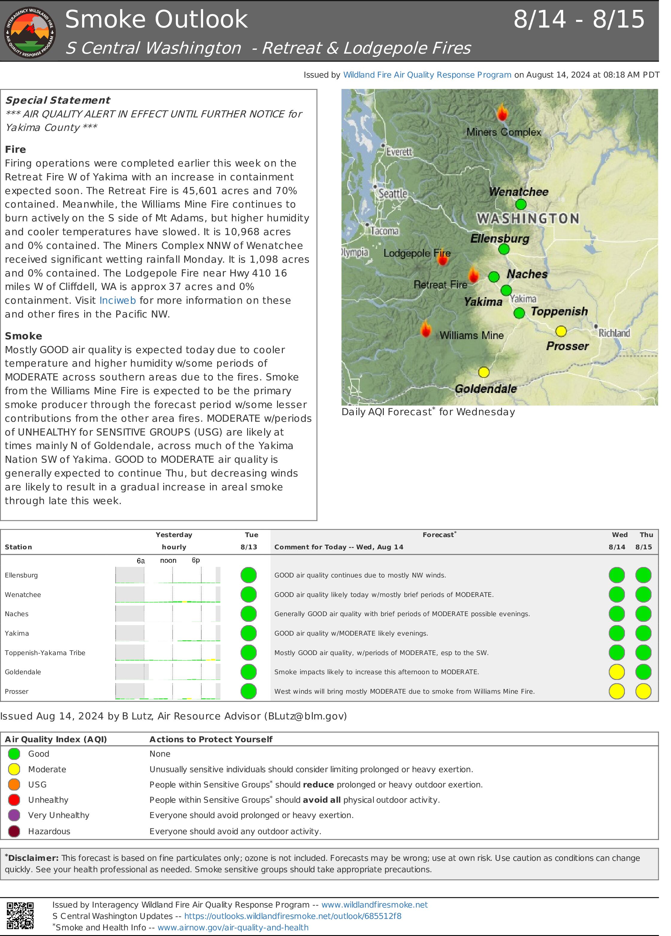
Retreat Fire Smoke Outlook ALERTA DE CALIDAD DEL AIRE 08 14 2024
Related Incident: Retreat
Publication Type: Announcement
Morning of Wednesday August 14 2024 08 14 2024
Related Incident: Park Fire
Publication Type: News
Morning of Wednesday, August 14, 2024
For more information on the Park Fire, please visit: https://inciweb.wildfire.gov/incident-information/calnf-park-fire
Size: 429,263 acres with 40% containment | Personnel: 5,579
Lassen National Forest:
Overnight the Park Fire remained within the current perimeter with personnel patrolling and locating remaining hot spots around the fire’s edge.
Today’s weather brings moderate levels of daytime humidity with seasonally normal temperatures. These weather conditions give opportunity for firefighters to safely remove hazard tress and improve fire lines.
Firefighters will actively engage the entire perimeter to improve containment lines, take aggressive efforts to remove hazard trees along roadways and the fire perimeter, and continue suppression repair. Interior pockets of unburned fuels continue to produce smoke and smolder, resulting in hazy conditions over the area.
The #ParkFire has burned 113,744 acres on the Lassen National Forest.
CAL FIRE:
There was minimal fire activity through the night. Firefighters are currently working on mop-up and tactical patrol operations to work towards containment and to prepare communities to be safe for repopulations. They are working to mitigate smokes, suppress spot fires, remove hazardous snags, and conduct suppression repair as well as improving both direct and indirect fire lines to prevent any potential flare-ups.
Today, slight increase in winds is expected over the region to the north. This week, seasonably warm and dry afternoons will be followed by nights with moderate to good humidity recovery.
As crews and equipment continue to work in the area, please remain cautious while traveling in the area.
For more information on the Park Fire please visit:
- CALFIRE Park Fire: https://www.fire.ca.gov/incidents/2024/7/24/park-fire
- CAL FIRE Shasta-Trinity Unit/Shasta County Fire Department: https://www.facebook.com/CALFIRESHU
- CAL FIRE Tehama-Glenn Unit/ Tehama County Fire Dept: https://www.facebook.com/CALFIRETGU
- Butte County, CA: https://www.facebook.com/ButteCounty
- Butte County Sheriff: https://www.facebook.com/bcsonews
- Plumas County Sheriff: https://www.facebook.com/plumascountysheriff
- Shasta County Sheriff: https://www.facebook.com/ShastaSheriff
- Tehama County Sheriff: https://www.facebook.com/profile.php?id=100088640404140
Middle Fork Complex Wapiti Bulltrout Daily Update 08 14 2024
Related Incident: Bulltrout Fire
Publication Type: News
Incident Commander: Rick Connell, Northern Rockies Team 5
Middle Fork Complex Location: 9 miles east of Garden Valley, ID
Bulltrout Location: 15 miles WNW OF Stanley, ID Wapiti Location: 2 miles southwest of Grandjean, ID
Start Dates: 07/24/24 – 08/06/2024
Cause: Lightning
Size:
Middle Fork Complex: Bulldog: 2,585 acres Nellie: 5,116 acres
Bulltrout: 271 acres Wapiti: 3,104 acres
Containment: Middle Fork Complex: 0% Bulltrout: 92% Wapiti: 0%
Resources on site:
Middle Fork Complex: 3 hotshot crews; 5 type 2 hand crews; 11 engines; 2 bulldozers; 4 water tenders
Wapiti: 1 type 2 hand crew; 8 engines; 1 water tender
Bulltrout: 1 engine
Total Personnel: Middle Fork Complex: 388 Bulltrout:18 Wapiti: 57
KEY MESSAGE:
On August 12, 2024, the Boise National Forest adjusted the fire closure areas. All roads and trails remain closed within these closures, to provide for public and firefighter safety. Please reference specific closures on the Forest’s website and the fire’s InciWeb page.
CURRENT STATUS/PLANNED ACTIONS:
Middle Fork Complex: The Middle Fork Complex is comprised of the Bulldog and Nellie fires.
On the Bulldog Fire, firefighters continue holding and extinguishing heat along the southern edge of the fire. As a result of successful strategic firing operations, crews have connected the fire perimeter to the 2006 Rattlesnake fire area and are looking for opportunities to continue to the east along the perimeter. On the north side of the fire, crews are looking for opportunities to use direct and indirect tactics to slow the spread to the west and north. The public is reminded that the Middlefork Road is closed at the Forest Service boundary just north of Lightning Creek for firefighter and public safety. Crews continue to work to protect private property and structures in the vicinity of Crouch.
The Nellie fire is burning in steep remote terrain and is backing into the 2016 Pioneer fire area. Crews are looking for natural barriers to utilize and continue to provide point protection to lookouts and a communication tower. The public is reminded that Forest Service Road #555 is closed at the intersection of Highway 17 all the way to the Forest Service Road #579 intersection.
Wapiti Fire: The Wapiti fire is actively burning in rugged high elevation terrain. It is primarily driven by winds on ridges in exposed areas. Firefighters continue to improve the water pumping system that provides sprinklers to the communities near the fire. In the Hanging Valley subdivision, crews are working to assess the needs for structure protection. As conditions become favorable, crews plan to conduct strategic ignition operations and line construction utilizing natural barriers and the 2018 Wapiti fire area. Smoke may be visible from State Highway 21 please use caution while driving in the area.
Bulltrout Fire: The fire is 92% contained and continues to smolder and creep through unburned areas within the interior of the fire. Firefighters continue patrolling and extinguishing pockets of heat, but dead standing trees are falling within the burn area limiting access.
WEATHER AND FIRE BEHAVIOR:
Yesterday a passing weather system brought showers to the area in the morning, along with cooler
temperatures and higher relative humidity. Today moisture will remain in place, keeping afternoon relative humidity elevated and allowing for overnight recovery across all elevations. Afternoon temperatures will remain in the 70s to low 80s, while winds continue to be terrain driven with gusts up to 15 mph. When the sky clears in the afternoon there is a potential for increased fire activity, spreading actively in various directions due to wind and terrain influences. The expected fire activity is group tree torching, short-range spotting and uphill or terrain driven runs.
CLOSURES, RESTRICTIONS, AND EVACUATIONS:
Middle Fork Complex: The Boise County Sheriff's Office continues to maintain the Level 2 evacuation notice for residents on and near the Middlefork Road between Stump Ranch Road up to Tie Creek Campground. The Boise National Forest issued an area closure for the fire (Closure #0402-06-59) effective August 12, 2024. The purpose of this order is to protect public safety during the fires.
Wapiti Fire: The evacuation order for Summer Homes and the Sawtooth Lodge remain in effect for the Wapiti Fire, as does the area closure issued by the Sawtooth and Boise National Forests (Closure #0402-05-94) effective August 12, 2024. This Order is for public and firefighter safety during fire suppression efforts of the Wapiti Fire.
Bulltrout Fire: The Bull Trout Fire Area Closure (Closure #0402-05-93) remains in effect for the roads and trails within the perimeter of the fire. Boise National Forest issued this order on August,12, 2024. It will be rescinded as soon as it is safe to do so.
Closure information and maps are posted on the Forests’ website and the fire’s Inciweb page as they are in place. https://tinyurl.com/2u8v3pf7
The Boise National Forest, Idaho Department of Lands, and Bureau of Land Management are in Stage 1 fire restrictions on state, endowment, private and federal lands within the West Central Mountains Fire Restrictions Zone. For more information on the restrictions and a map visit:
https://www.idl.idaho.gov/fire-management/fire-restrictions-finder/
Homestead Complex Fire Update08 14 2024
Related Incident:
Publication Type: News
The Homestead Complex includes seven fires totaling 4,387 acres with an overall containment of 17%. There are 591 personnel currently working on the fire. Fire managers continue directing resources to fires based on threats to property, infrastructure, industry, and areas with the highest probability of success while providing for firefighter and public safety. The fire is being managed by Northwest Incident Management Team 8.
Yesterday, on the No Man Fire (1,660 acres), crews worked tactical firing operations westward on the south side of the fire. To the north, firefighters focused on holding, maintaining and strengthening control lines. Two engines patrolled the area overnight. The Salmon 33 (244 ac.) Fire continued to stay within its footprint as fire personnel mopped up and continued to establish containment. Horse Heaven Creek Fire (1,369 ac.) had a couple small spot fires that were caught by firefighters, and the two-acre spot from the day before remained secured. Crews continued burnouts down the eastern flank of the fire, reaching the 070 Road. On the northwest flank, fire has crossed control lines near the bottom of Windy and Horse Heaven Creek drainages. Mop-up continued to the south. On the Bullpup Fire (413 ac.), helicopter bucket drops were used to moderate some increased fire activity on the western side of the fire. Fire leadership determined the best route to continue hand and dozer line work to the northeast. Engines patrolled the 300 Road, keeping fire from crossing the road. On the Fuller Lake Fire (332 ac.), crews were engaged in holding and searching for containment opportunities to the north. The Reynolds Butte Fire (335 ac) continued to show little activity and crews continued mopping up in that area.
Today, on the No Man Fire, tactical firing operations to the south will continue and build on yesterday’s progress. To the north side, crews will be working burnouts to the east and prepping the 3811 and 3815 roads from north toward the south and Salmon 33 Fire. Crews on the Salmon 33 Fire are working to tie up the indirect line to the west between No Man and Salmon 33. Monitoring and mop-up efforts continue with minimal fire activity. On the Horse Heaven Creek Fire, there’s still some moderate fire activity. Crews will continue moving firing operations south down the eastern flank toward the 059 Road. To the north, firefighters will be scouting today for strategic opportunities to pick up the fire that crossed planned control lines. Contingency line work is progressing on the 5850 and 010 roads. Firefighters assigned to the Bullpup and Fuller fires continue to keep the fires within the road systems and control lines. The 5851 Road by Fuller Lake is still holding, and crews will continue patrolling and holding it as they work up and around and prep lines to the west and south. On Bullpup, fire personnel have dozer lines tied into handline near the 300 Road. Burning operations will expand in the coming days. The Reynolds Butte Fire remains close to patrol status. Firefighters continue to wind down operations there and will be reallocated around the complex once work is complete. The Lost Bucket Fire (34 ac.) was contained on July 29 and remains in a patrol status.
Today’s weather: Overnight relative humidity recovery was good, in the 70 to 90 percent range. Temperatures will be 3-5 degrees warmer than yesterday and ranging in the 70s and potentially 80s at the lower elevations. Relative humidity is expected to be in the 40s. Terrain-driven winds during the morning and noon hours will pick up at the higher elevations into the afternoon, with west-northwesterly gusts up to 20 mph possible and potential for an uptick in gusts on the ridges.
Current forest fire restrictions and danger ratings are -
Fire Danger Rating: Very High
Industrial Fire Precaution Levels (IFPL): 3
Public Use Fire Restrictions (PUR): 3
CLOSURES:
The Bureau of Land Management (BLM), Roseburg District, has issued a closure order for portions of BLM land which border the Umpqua National Forest Emergency Fire Closure north of Steamboat. The closure order can be viewed here: https://www.blm.gov/sites/default/files/docs/2024-07/orwa-fpo-rbg-072624.pdf.
The Umpqua National Forest has Emergency Fire Closures in place impacting every district of the forest. https://www.fs.usda.gov/alerts/umpqua/alerts-notices.
Fire Prevention:
Continue to check for Fire Restrictions when recreating or working outside. Agencies use weather forecasts, the current regional and national fire situation, resource availability and many other factors to calculate appropriate fire restriction levels. Do your part to help keep unwanted human fire starts off of the landscape!
August 14 2024 Boise Fire Update 08 14 2024
Related Incident: 2024 Boise Fire
Publication Type: News
Headlines
- No structures have been reported as damaged or destroyed despite yesterday’s significant fire run.
- Join us TOMORROW, Thursday, August 15 at 2 p.m. for an online Ask the Incident Commander information meeting. Link TBD.
- Get all your Boise Fire information in one mobile-friendly place! https://linktr.ee/2024boisefiresrf
- UDPATED EVACUATIONS HAVE BEEN ISSUED. Evacuations are in place for the Boise Fire for residents near the fire area in Humboldt County and Siskiyou County. For the most current evacuation information please visit the Boise Fire linktree or visit:
Humboldt County: https://humboldtgov.org/356/Office-of-Emergency-Services
Siskiyou County: https://www.co.siskiyou.ca.us/emergencyservices
Leader’s Intent: The Boise Fire is being managed with a full suppression strategy.
Operational Update: Critical fire behavior was observed yesterday after the inversion lifted and the fire got into alignment with the Boise Creek drainage. The growth was primarily to the east.. Crews had spent the previous days opening and improving lines along Antenna Ridge and those were defended overnight west of Orleans Mountain although significant spotting occurred. Crews were able to get hose lays into the area after activity decreased, and they continued to contain and mop up those spots into the early morning hours. Despite the fire activity, crews were able to continue firing off the Antenna Ridge Road to deepen containment to provide protection for Orleans. Structural assessments will continue today with a large influx of resources coming in to assist.
Crews began looking for opportunities to contain the fire on its east side yesterday. This could include locating and re-opening previous fire lines.
Weather and Fire Behavior: The weather today is anticipated to be similar to yesterday, with cooler temperatures and good overnight moisture recovery. All the elements remain in place for active fire behavior after the inversion lifts in the afternoon. Fuels remain critically dry in the fire area, and the fire has been primarily driven by those heavy, dry fuels and the area topography.
###
Middle Fork Complex Wapiti Bulltrout Daily Update 08 14 2024
Related Incident:
Publication Type: News
Incident Commander: Rick Connell, Northern Rockies Team 5
Middle Fork Complex Location: 9 miles east of Garden Valley, ID
Bulltrout Location: 15 miles WNW OF Stanley, ID Wapiti Location: 2 miles southwest of Grandjean, ID
Start Dates: 07/24/24 – 08/06/2024
Cause: Lightning
Size:
Middle Fork Complex: Bulldog: 2,585 acres Nellie: 5,116 acres
Bulltrout: 271 acres Wapiti: 3,104 acres
Containment: Middle Fork Complex: 0% Bulltrout: 92% Wapiti: 0%
Resources on site:
Middle Fork Complex: 3 hotshot crews; 5 type 2 hand crews; 11 engines; 2 bulldozers; 4 water tenders
Wapiti: 1 type 2 hand crew; 8 engines; 1 water tender
Bulltrout: 1 engine
Total Personnel: Middle Fork Complex: 388 Bulltrout:18 Wapiti: 57
KEY MESSAGE:
On August 12, 2024, the Boise National Forest adjusted the fire closure areas. All roads and trails remain closed within these closures, to provide for public and firefighter safety. Please reference specific closures on the Forest’s website and the fire’s InciWeb page.
CURRENT STATUS/PLANNED ACTIONS:
Middle Fork Complex: The Middle Fork Complex is comprised of the Bulldog and Nellie fires.
On the Bulldog Fire, firefighters continue holding and extinguishing heat along the southern edge of the fire. As a result of successful strategic firing operations, crews have connected the fire perimeter to the 2006 Rattlesnake fire area and are looking for opportunities to continue to the east along the perimeter. On the north side of the fire, crews are looking for opportunities to use direct and indirect tactics to slow the spread to the west and north. The public is reminded that the Middlefork Road is closed at the Forest Service boundary just north of Lightning Creek for firefighter and public safety. Crews continue to work to protect private property and structures in the vicinity of Crouch.
The Nellie fire is burning in steep remote terrain and is backing into the 2016 Pioneer fire area. Crews are looking for natural barriers to utilize, and continue to provide point protection to lookouts and a communication tower. The public is reminded that Forest Service Road #555 is closed at the intersection of Highway 17 all the way to the Forest Service Road #579 intersection.
Wapiti Fire: The Wapiti fire is actively burning in rugged high elevation terrain. It is primarily driven by winds on ridges in exposed areas. Firefighters continue to improve the water pumping system that provides sprinklers to the communities near the fire. In the Hanging Valley subdivision, crews are working to assess the needs for structure protection. As conditions become favorable, crews plan to conduct strategic ignition operations and line construction utilizing natural barriers and the 2018 Wapiti fire area. Smoke may be visible from State Highway 21 please use caution while driving in the area.
Bulltrout Fire: The fire is 92% contained and continues to smolder and creep through unburned areas within the interior of the fire. Firefighters continue patrolling and extinguishing pockets of heat, but dead standing trees are falling within the burn area limiting access.
WEATHER AND FIRE BEHAVIOR:
Yesterday a passing weather system brought showers to the area in the morning, along with cooler
temperatures and higher relative humidity. Today moisture will remain in place, keeping afternoon relative humidity elevated and allowing for overnight recovery across all elevations. Afternoon temperatures will remain in the 70s to low 80s, while winds continue to be terrain driven with gusts up to 15 mph. When the sky clears in the afternoon there is a potential for increased fire activity, spreading actively in various directions due to wind and terrain influences. The expected fire activity is group tree torching, short-range spotting and uphill or terrain driven runs.
CLOSURES, RESTRICTIONS, AND EVACUATIONS:
Middle Fork Complex: The Boise County Sheriff's Office continues to maintain the Level 2 evacuation notice for residents on and near the Middlefork Road between Stump Ranch Road up to Tie Creek Campground. The Boise National Forest issued an area closure for the fire (Closure #0402-06-59) effective August 12, 2024. The purpose of this order is to protect public safety during the fires.
Wapiti Fire: The evacuation order for Summer Homes and the Sawtooth Lodge remain in effect for the Wapiti Fire, as does the area closure issued by the Sawtooth and Boise National Forests (Closure #0402-05-94) effective August 12, 2024. This Order is for public and firefighter safety during fire suppression efforts of the Wapiti Fire.
Bulltrout Fire: The Bull Trout Fire Area Closure (Closure #0402-05-93) remains in effect for the roads and trails within the perimeter of the fire. Boise National Forest issued this order on August,12, 2024. It will be rescinded as soon as it is safe to do so.
Closure information and maps are posted on the Forests’ website and the fire’s Inciweb page as they are in place. https://tinyurl.com/2u8v3pf7
The Boise National Forest, Idaho Department of Lands, and Bureau of Land Management are in Stage 1 fire restrictions on state, endowment, private and federal lands within the West Central Mountains Fire Restrictions Zone. For more information on the restrictions and a map visit:
https://www.idl.idaho.gov/fire-management/fire-restrictions-finder/
WEST MOUNTAIN COMPLEX Boulder Snag and Dollar Fires Update 08 14 2024
Related Incident:
Publication Type: News
**Goat Fire Daily Update 8-14-2024**
Firefighters continue to scout for opportunities to connect constructed fireline to the Snag Fire to slow growth. With aviation resources, fire managers are keeping an eye on the fire in the Middle Fork of the Payette River for signs of fire spread. Beyond water drops, helicopters can be used on fires reconnaissance and decision-making. These resources are crucial in managing wildfires, especially in an area that is difficult to access by ground crews.