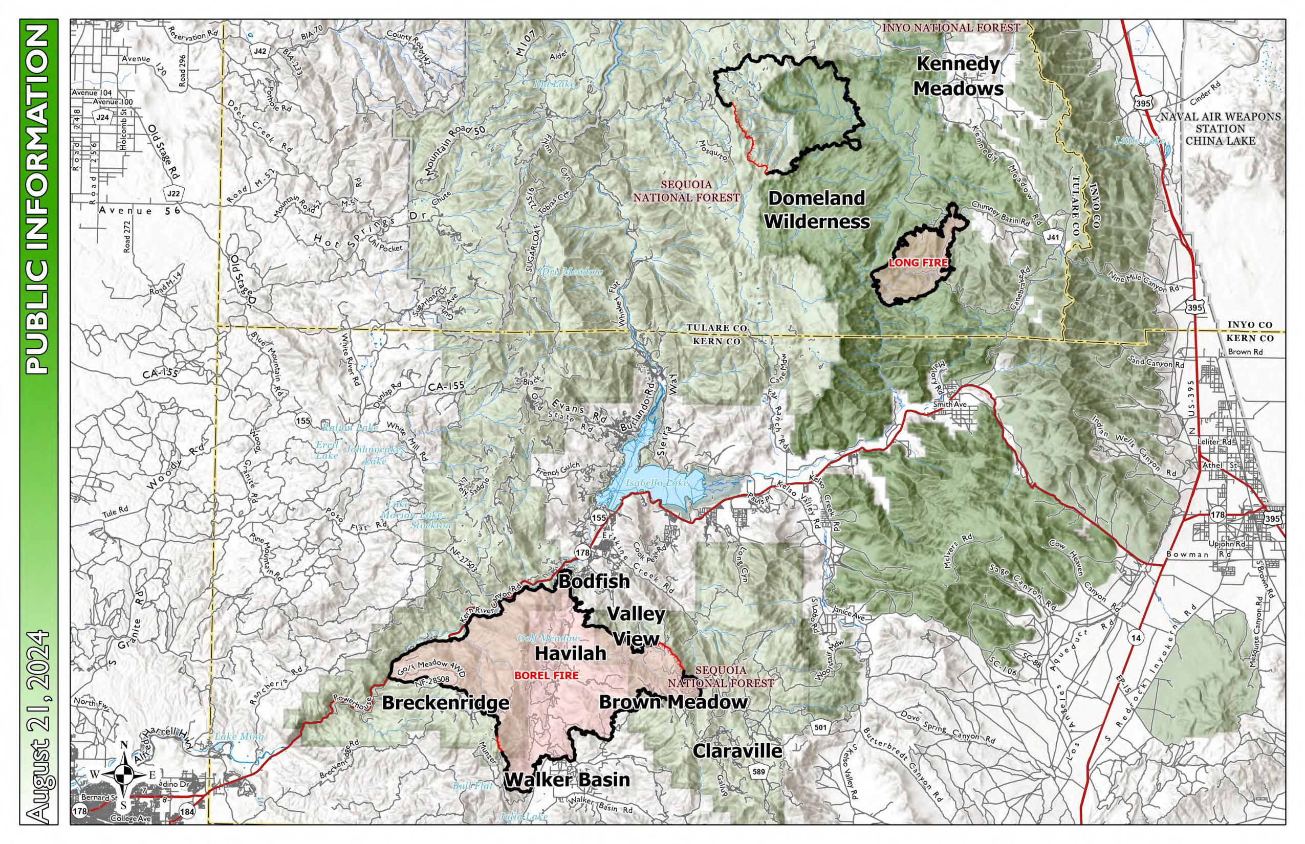
U.S. flag

An official website of the United States government

Here's how you know

Single Incident Information

Zoom to your location
Reset map zoom and position

Could not determine your location.

Borel Fire

Unit Information

220 E. Morton Ave 
Porterville, 
93257 
220 E. Morton Ave 
Porterville, 
93257 

Incident Contacts

Email: 2024.lightning@firenet.gov
Phone: 559-481-7849
Hours: 8 am - 8 pm

Highlighted Activity

Trout Fire: 23,369 acres - 33% containmentLong Fire: 9,204 acres - 95% containmentBorel Fire:  53,010 acres | 0% containedTotal Personnel: 1,059 For more information on the Borel Fire, visit: https://inciweb.wildfire.gov/incident-information/casqf-borel-fireFor more information on the SQF Lightning Fires, visit: https://inciweb.wildfire.gov/incident-information/casqf-2024-sqf-… Read more
Publication Type: News -

Highlighted Media

On July 24, 2024, the Borel Fire started on the south side Highway 178 near the Democrat Fire Station on the Kern River Ranger District in (Kern County). The cause is under investigation.

This fire was previously reported under 2024 SQF Lightning.

California Complex Interagency Incident Management Team assumed Unified Command today at 0700 hours with Kern County Fire.

Basic Information
Current as of Mon, 07/29/2024 - 16:03
Incident Time Zone America/Los_Angeles
Incident Type Wildfire
Cause Undetermined
Date of Origin
Location 12 miles SW of Lake Isabella
Incident Commander California Interagency Incident Management Team 11 Incident Comander Chris Fogle and Kern County Fire Department Incident Commander Jake Cagle
Coordinates 35° 30' 54'' Latitude
-118° 41'
1
'' Longitude
Current Situation
Total Personnel: 907
Size 53,010 Acres
Percent of Perimeter Contained 0%
Fuels Involved

Brush (2 feet)
Short Grass (1 foot)
Timber (Litter and Understory)

The primary carrier is grass, with shrub, and timber understory. ERCs, Live Fuel Moisture and 1000 hr. fuels are near normal, but the unusual grass crop is driving fire spread coupled with the very dry and windy conditions. 

Significant Events

Expect extreme fire behavior with torching, wind driven runs and long-range spotting in grass, brush and timber. Fire may exhibit very high rates of spread, high intensity and difficulty of control. The fire is burning aggressively through the steep rugged terrain of the Piute Mountains. Spotting has been observed beyond 1/2 mile with sustained runs through the mixed conifers supported by a continues crop of fully cured annual grasses. 

Outlook
Planned Actions

The plan is for resources to continue with direct line construction supported by aircraft where feasible and look for control features where direct line is not possible. Utilizing Kern Canyon road and the Kern River and other features to hold fire South and east of the 178. Use dozers to prep around communities and build indirect line. Assessing and prepping structures ahead of the fire spread. Identify areas for indirect line or proposed secondary strategic lines. Coordinate evacuation efforts with local law enforcement and cooperators. DINS teams will be conducting assessment of the Havilah area as well as scattered sites impacted by the fire. 

Projected Incident Activity

Moderate to rapid fire spread will continue to move to the east and north potentially impacting structures and infrastructure in Bodfish, Moreland Mill, and French Meadow areas. Movement to the south will impact Walker Basin. 

Current Weather
Weather Concerns

A Red Flag Warning is in effect for the SQF Lightning / Borel fires thru 11pm Monday (7 /29). 

Gusty ridgetop and gap winds will continue to impact the fire area over the next few days along with critically low RH this week will lead to an extended period of elevated fire weather.  Slightly cooler air will filter into the region today and early next week before a warming trend begins on Wednesday. The very dry air mass will remain in place at least thru midweek along with gusty west winds that will impact exposed slopes and terrain gaps.