
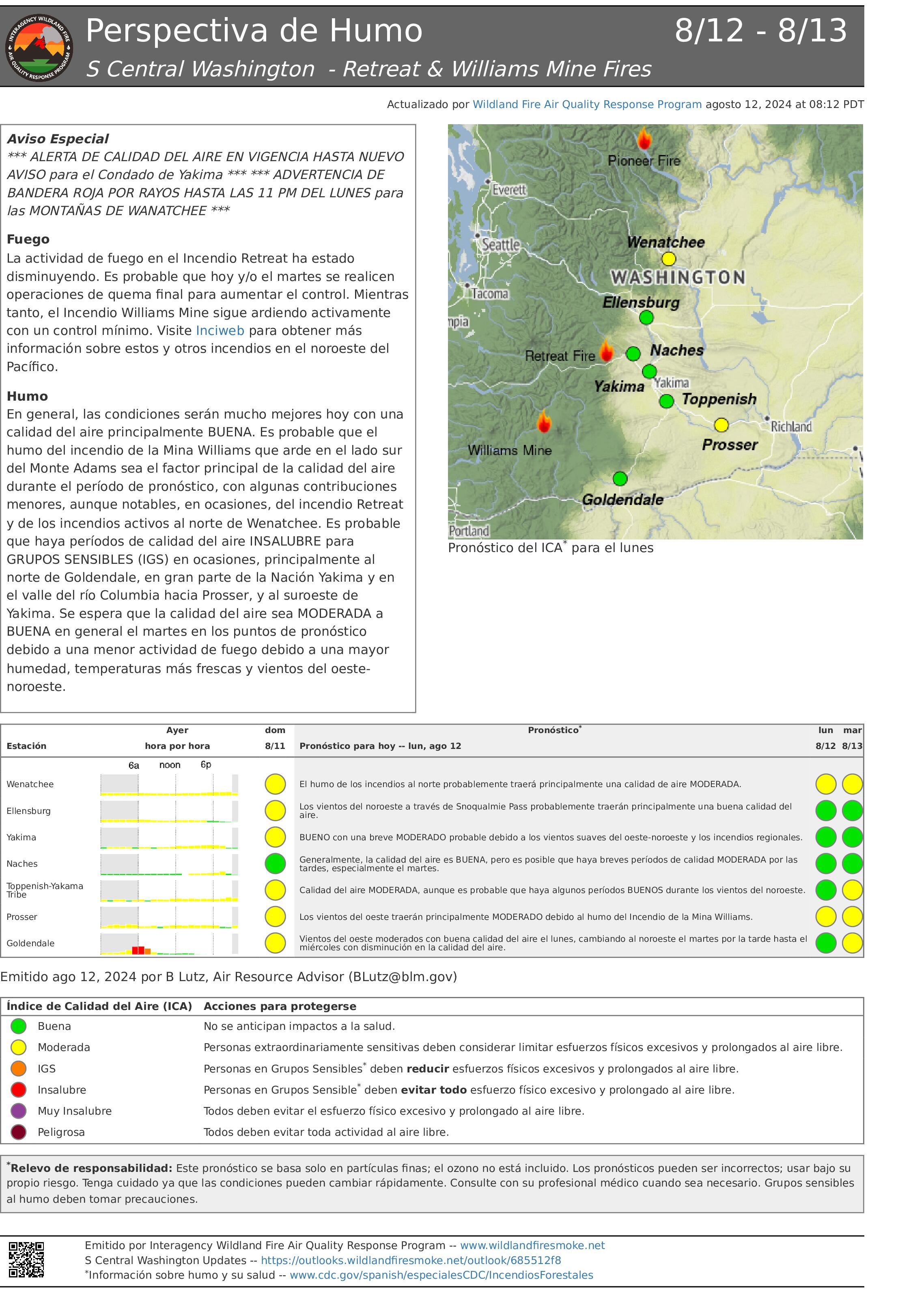
Retreat Fire Smoke Outlook ALERTA DE CALIDAD DEL AIRE 08 12 2024
Related Incident: Retreat
Publication Type: Announcement
Cottage Grove Lane 1 Fire Update 08 12 2024
Related Incident: Lane 1 Fire
Publication Type: News
Warm, windy weather prompts small spot fires outside lines on Lane 1 Fire, both lined overnight
COTTAGE GROVE, Ore. – Firefighters are mopping up two small spot fires that was found outside of eastern containment lines on the Lane 1 Fire late Sunday afternoon. Temperatures in the 90s and windy conditions caused the fire to spot beyond the line. Resources on the ground and aircraft immediately responded, and as a result, both were caught at less than five acres. Cloud cover and high relative humidity this morning will help resources on the line by naturally decreasing fire behavior throughout the morning. The fire is currently 21,658 acres and containment has increased to 14%.
Today, resources will continue to focus on the southeast side of the fire, where certain portions of line need to be connected and strengthened. There are large pockets of unburned fuel in this area that are posing a challenge; firefighters are planning for strategic firing operations when conditions line up. Once this work is complete, fireline in this area will be stronger and provide a
August 12 Smoke Outlook 08 12 2024
Related Incident: Park Fire
Publication Type: News
Special Statement/ Declaración Especial
Smoke from fires surrounding the Outlook area continue to impact the locations.
El humo del nuevo incendio al sur de Orleans puede afectar la parte oeste del área dentro de la Perspectiva.
Fire/ Incendio
The fire is at 429,188 with 38% containment. The fire continues to be active in the Mill Creek drainage and in the interior of the perimeter due to heavy, dry fuels. Gusty winds are expected again today.
El incendio se encuentra en 429,188 acres con un 37% de contención. El incendio continúa activo en el drenaje de Mill Creek y en el interior del perímetro debido a combustibles pesados y secos. El comportamiento del fuego será moderado hoy con la sombra del humo hasta que la inversión se disipe a última hora de la tarde. El aumento del viento podría provocar un comportamiento de fuego más activo esta tarde.
Smoke/ Humo
Any smoke from the Park Fire will impact the areas closest to the most active portion of the fire, the Mill Creek drainage area. Air quality is overall Good to Moderate in all communities.
El humo continúa afectando a Shingletown y Chester. Chester podría permanecer en el rango IGS durante todo el día y permanecerá en el área de Lake Almanor hasta que los vientos puedan despejar el humo. Las áreas al oeste del incendio tienen condiciones de calidad de aire de Buena a Moderada. El humo debería disminuir en estas áreas hoy debido a los vientos del oeste y suroeste.
Be Smoke Aware/ Esté atento al humo
If you smell smoke and it is impacting you, seek relief if possible.
Si huele humo y le está afectando, busque alivio si es posible.
Diamond Complex and Middle Fork Daily Update 08 12 2024
Related Incident: Middle Fork Fire
Publication Type: News
The Diamond Complex on the Umpqua National Forest consists of 27 lightning-caused fires totaling approximately 8,466 acres, with 734 people assigned. The Middle Fork Fire in the northwest corner of Crater Lake National Park has 31 people assigned, but the Diamond Complex is sharing resources as needed. The park remains open.
KEY MESSAGES: The North Entrance Road in the park will be closed for approximately seven days beginning Tuesday, August 13th for firefighters to prepare control lines. Visit https://www.nps.gov/crla/learn/news/crater-lake-temporarily-closes-north-entrance-for-the-middle-fork-fire.htm for details.
Highway 230 along the northwest corner of Crater Lake National Park will be one-lane traffic with a flagger and pilot car due to work occurring on the Middle Fork Fire. Expect delays and plan accordingly.
OPERATIONS:
Middle Fork Fire (4,929 acres, 0% contained): On the western flank crews continue road preparation using mastication and scouting for secondary containment lines. Significant heat and continuous fuels on the southwest flank pose operational challenges and personnel are looking for opportunities for indirect line construction to mitigate the spread potential. On the northern portion of the fire up to HWY 230, crews are establishing several starting and stopping points for potential future firing operations. In conjunction with the potential firing operations, to the north-northeast between HWY 230 and HWY 138, crews have installed hose lays on dozer lines. Yesterday, outside the north entrance road to Crater Lake National Park, crews and heavy equipment operators did not implement the trial run of clearing vegetation as planned. This trial run of a light-handed approach to vegetation clearing is set to happen in the coming days. If determined appropriate, this method will continue inside the park on the north entrance road.
Perimeter fire growth was minimal yesterday overall, while the eastern flank has crept to the bottom of Devils Ridge, and hot spots have revealed to the southwest. Uphill runs at Devils Ridge are possible today with higher wind speeds. Air resources, including helicopters for water bucket drops and recon flights and unmanned aircraft systems (drones) for infrared imaging and firing operations remain available. The Pacific Crest Trail from the Dutton Ridge Intersection to Hwy 138, Lightning Springs, Bald Crater Loop, Bert Creek, and Boundary Springs Trails (within the park) are closed.
Diamond Complex Fires
Pine Bench Fire (North of Hwy 138 near Dry Creek, 2,221 acres, 51% contained): Yesterday, infrared imaging from a drone recon flight confirmed the Pine Bench Fire is holding in the Boulder Creek drainage. To the north, the fire perimeter is retaining heat, and the potential for spread remains. On the eastern flank, fire crews continue making progress to meet mop-up standards and secure established fire line along Forest Service (FS) Road 4774. To the west of the Boulder Creek Wilderness, road preparation continues on FS 4670. Road preparation on Forest Service Roads 3402 and 3400 between the Pine Bench and Potter Fires is near completion and crews are shifting focus to improving contingency lines.
Potter Fire (North of Hwy 138, two miles southeast of Potter Mountain, 2440 acres, 0% contained): To the east masticators will be working to improve current dozer line. On the western flank, a location for dozer line has been identified, and work to build this feature is expected to start today. To the north, the fire has reached the old burn scar of the 2022 Potter Fire and fire personnel are looking for areas to safely access the fire.
Ooya Fire (North of Hwy 138, one mile northeast of Bird Point, 345 acres, 0% contained): Firefighters rapidly responded to spot fires on the northwest perimeter yesterday, preventing spread. Established lines on the eastern and western flanks are holding, and crews are improving secondary containment features.
Campwood Fire (Two miles south of Hwy 138, 20 acres, 0% contained), Wood Fire (Two miles south of Hwy 139, 23 acres, 58% contained), Trap Fire (One mile south of Hwy 138 near Trap Mountain, 17 acres, 0% contained): Firefighters are focused on securing these fire perimeters and reaching mop up status in order to shift attention to the Trep Fire to the south.
Brodie Fire (Five miles south of Hwy 138, south of Devils Canyon, 195 acres, 0% contained): Masticator work will continue today on the southern portion of the fire. The potential for spread to the indirect containment lines on the southwest is possible today. Water from Skookum Lake is being pumped to hose lays on the fire’s edge.
Lemolo Fire (North of Lemolo Lake on Bunker Hill, 1247 acres, 29% contained): Firefighters are mitigating road hazards on the southern fire perimeter, north of Lemolo Lake. Fire crews are reaching mop-up standards further around the perimeter every day.
Trep Fire (About four miles south of Hwy 138, 453 acres, 0% contained): Strategies are being developed on the eastern flank as resources become available from other fires that have been secured.
Trail Fire (East of Hwy 138 on the west slope of Mt. Thielsen, 844 acres, 48% contained): Firefighters will continue to mop up and secure the fire perimeter today, addressing hot spots to the northeast into the Mount Thielsen Wilderness.
Other fires within the Diamond Complex:
Loafer Fire (42 acres, 59% contained)
Rough Fire (11 acres, 0% contained)
Thin Fire (Four miles northwest of Diamond Lake, 0.6 acre, 52% contained)
Lost Fire (Northeast of Trep Fire, 58 acres, 0% contained)
WEATHER AND FIRE BEHAVIOR: Today will have cooler temperatures, higher humidity levels, and bring an uptick in the west-southwest winds with potential gusts of up to 20 mph on ridge tops. Fingering and flanking runs will be
possible under a shorter burn period, but growth will depend on clear air.
SMOKE OUTLOOK: Smoke will remain in the area and may reduce visibility and hinder air operations. For the most up to date information, please visit fire.airnow.gov/
CLOSURES, RESTRICTIONS, EVACUATIONS: Umpqua National Forest has two closures in place across the forest in response to fire activity to protect public and wildland firefighter safety. Emergency Fire Closure ORDER NO. 06-15-24-05 and Emergency Fire Closure ORDER NO. 06-15-02-24-01 impacts all the Cottage Grove Ranger District, most of the Diamond Lake Ranger District, and parts of the Tiller and North Umpqua Ranger Districts. The closure orders can be found here: www.fs.usda.gov/alerts/umpqua/alerts-notices. Fire danger is set at VERY HIGH, and Public Use Restrictions Level 3 ORDER NO. 06-15-24-04 is in effect: https://tinyurl.com/PublicUseRestrictions
The Douglas County Sheriff’s Office evacuation order for the Trail Fire west of Hwy 138 is set at Level 1: Get Ready and east of Hwy 138 is set at Level 3: GO NOW. The evacuation order for the Lemolo Fire south of Lemolo Lake is set at Level 1: Be Ready and northeast of Lemolo Lake is set at Level 3: GO NOW. There is still a Level 2: BE SET for the Pine Bench Fire. There is also a Level 2: BE SET for the Potter Fire. For an interactive map of evacuations, visit the Douglas Co. Sheriff’s Office website: www.dcso.com/evacuations
Williams Mine Fire Update 08 12 2024
Related Incident: Williams Mine Fire-GPNF
Publication Type: News
Williams Mine Fire Update for Monday, August 12, 2024
KEY MESSAGE:
The structure protection group had a successful day as operational resources arrived and built upon previous days’ fire mitigation efforts around private infrastructure within level 3 evacuation zones near Trout Lake, WA. NW-13 continues to work with local government officials prioritizing firefighting efforts within the communities directly adjacent to the fire.
CURRENT STATUS:
A new fire was detected yesterday approximately one-half mile west of the 23 road. Resources were available to actively engage this new start, and aviation resources were utilized to suppress the new ignition. Ground firefighting resources are constructing perimeter control lines to achieve containment.
On the northwest side of the fire perimeter, crews continue to scout and identify potential containment lines to tie fire spread into natural features. Dozers are being used to connect geographical features along the 8031 road as crews look for opportunities to limit fire spread from progressing to the south.
To the east on the 060 road, crews are suppressing spot fires that were established yesterday around Snipes Mountain. Due to rugged and steep terrain, spot fires to the southeast of the fire perimeter are difficult to access, and a heavy snag component also is present in this area from previous fire scars. Firefighters are developing strategies to gain anchor points in this area utilizing indirect line construction control features. Fire managers anticipate easterly progression to continue due to the strong westerly winds being forecasted.
WEATHER:
Active weather with stronger winds will arrive with gusts possibly exceeding 25 mph; however, relative humidities will rise at elevations below 4000 feet providing moisture to the environment. Fog may also accumulate in lower elevations on Tuesday, and Wednesday morning. This weather change also has the potential for thunderstorms arriving Thursday, which may provide measurable precipitation which could aid in slowing fire progression on the Williams Mine Fire.
CLOSURES:
Effective immediately, Washington DNR managed lands near Trout Lake and Glenwood will be closed to entry due to the Williams Mine fire. For more information, please see http://www.dnr.wa.gov/ahtanum. The Confederated Tribes and Bands of the Yakama Nation, Tract D Recreation Area is closed, please see Yakama Tract D Road Closure for more information. Level 2 & 3 evacuations are in effect for the community of Trout Lake. An evacuation center is located at 1455 NW Bruin County Road, White Salmon, Washington. Evacuations are coordinated through the Klickitat County Sheriff’s Office and the Skamania County Sheriff’s Office. The FS-23 and FS-25 roads are closed, see the Williams Mine Area and Road Closure for more details. The Pacific Crest Trail (PCT) is closed from the PCT's intersection with FS 23 to Potato Hill. The current Forest closure spans the entire Mt. Adams Wilderness.
Smoke Outlook for Mid Columbia Gorge Area 08 12 2024
Related Incident: Sandstone FireWhisky Creek Fire
Publication Type: Announcement
Fire
On the Whisky Creek Fire, crews completed and are monitoring indirect handlines while helicopters with buckets drop water directly on any active fire. Today, winds will be westerly and temperatures in the 60s are expected. The
Whisky Creek Fire is currently 1750 acres. The Sandstone Fire is creeping and smoldering within the perimeter of a
wildfire that burned in 2006. Some increased fire activity is expected this afternoon. An indirect suppression strategy is currently being explored. The fire is 602 acres in size. On the Williams Mine Fire, west winds and drier air will increase fire activity. The fire is 10584 acres in size.
Fuego
En el Incendio Whisky Creek, los equipos completan y monitorean líneas de defensa indirectas mientras que los
helicópteros con cubetas de agua la dejan caer directamente sobre cualquier fuego activo. Hoy, se esperan
vientos del oeste y temperaturas en los 80 grados. El Incendio Whisky Creek tiene actualmente 1,743 acres. El
Incendio Sandstone se está extendiendo y en combustión lenta dentro del perímetro de un incendio forestal que
ocurrió en 2006. Se espera un aumento en la actividad del fuego esta tarde. Actualmente se está explorando una
estrategia de supresión indirecta. El incendio tiene un tamaño de 612 acres. En el Incendio Williams Mine, los
vientos del oeste y la sequedad aumentarán la actividad del fuego. El incendio tiene un tamaño de 7,297 acres.
Smoke
Winds will be more westerly which will clear smoke in much of the outlook area. Winds are expected to remain westerly through the period. Air quality will generally be between Good to Moderate for much of the smoke outlook area with localized areas of smoke pooling for locations nearest to the Williams Mine, Whisky Creek, and Sandstone Fires.
Humo
Los vientos serán más del oeste y eliminarán el humo en gran parte del área de pronóstico. Se espera que los
vientos sigan siendo del oeste durante todo el período. La calidad del aire será generalmente de Buena a Moderada
en gran parte del área dentro de la perspectiva de humo, con áreas localizadas de acumulación de humo en las
ubicaciones más cercanas a los incendios Williams Mine, Whisky Creek y Sandstone.
Smoke Outlook East Central Oregon 08 12 2024
Related Incident: Lone Rock FireCourtrock Fire
Publication Type: News
Smoke Outlook 8/12 - 8/13
East Central Oregon
Special Statement
Isolated Afternoon and Evening Storms with Occasional Lightning and Gusty winds.
Fire
There are multiple fires affecting Central Oregon. For more information on these incidents, please visit Inciweb.
Smoke
Reduced fire activity over central Oregon has led to MODERATE with locally GOOD air quality. Weather conditions with moisture and a few storms will confine smokiest conditions to the proximity of active fires today, namely Seneca. The forecast is for largely MODERATE conditions over most of the region through afternoon with improvements late due to development of Northwest winds. Air quality is expected to remain MODERATE on average Tuesday largely due to effects from regional fires.
Paint Crossing Fire Daily Update August 12 2024 08 12 2024
Related Incident: Paint Crossing Fire
Publication Type: News
Paint Crossing Fire Daily Update
Monday, August 12, 2024
August 12, 2024
Size: 2,362 acres
Containment: 95%
Date Started: August 7, 2024
Cause: Under investigation
Structures: At this time crews have not identified any damaged structures.
Evacuations: There are no evacuations in place at this time.
The Paint Crossing Fire started on August 7, 2024, and initially was responded to by local fire departments from Throckmorton County. Texas A&M Forest Service was requested for assistance at 3:00 p.m. and responded with aviation resources, heavy equipment, and engines from Texas A&M Forest Service and Texas Intrastate Fire Mutual Aid System (TIFMAS). Texas A&M Forest Service is currently in unified command with Throckmorton County fire departments.
Closures: There are no road closures at this time.
Yesterday: Firefighters worked in high heat yesterday working to continue improving containment lines and extinguishing areas of heat. Fire activity was minimal initially yesterday and became more active over the course of the day. Crews worked to monitor the previous spot fires while others also patrolled the main body of the fire for any areas of heat or fire activity. A helicopter was utilized later in the day to assist with an area of the main fire that became more active after a day of high temperatures and winds.
Today: Resources will be back on scene again today, patrolling and monitoring the areas of the fire that have caused concern over the past several days. With a drying trend in the forecast, firefighters are working to make sure that this fire will remain contained in its current perimeter. Some of the resources on this fire have been reassigned back to their home units so that they can be ready for any new fire starts in the area. These resources will take time to rest their bodies and repair their equipment so that as new requests for assistance come in they will be ready to respond.
Weather and Fire Behavior: Temperatures are forecasted to be in the triple digits starting today which will dry grass and brush, potentially making them more available for fires. Relative humidities will be low but remain above the critical threshold. With higher winds forecasted crews will be looking for more active behavior potentially and actively patrolling to ensure there are no new spot fires.
Fire Information
Adam Turner Information Officer
Public Information Officer, Texas A&M Forest Service Texas A&M Forest Service
Email: adam.turner@tfs.tamu.edu information@tfs.tamu.edu
Phone: 940-328-9158 979-255-0591
Inciweb: https://inciweb.wildfire.gov/incident-information/txtxs-paint-crossing
Facebook: https://www.facebook.com/AllHazardsTFS
Twitter: https://twitter.com/AllHazardsTFS
Actualizacin Sobre El Incendio Courtrock Lunes 08 12 2024
Related Incident: Courtrock Fire
Publication Type: News
El incendio Courtrock se transferirá a un equipo de manejo de incidentes de tipo 3.
Acres: 20,019 acres | Fecha de inicio: 21 de Julio 2024 | Causa: Rayo | Combustibles: Madera, hierba, arbustos.
Contención: 97% | Recursos: 250
Lunes, 12 de Agosto de 2024
Puntos Sobresalientes: Esta actualización será la última del Equipo De Manejo De Incidentes Complejos Del Área Suroeste, que entregará la administración del incendio Courtrock al Equipo Interagencial de manejo de Incidentes de High Desert, el comandante del incidente Chris Cook, a partir de las 6 p.m. el lunes 12 de agosto. Un equipo de Tipo 3 es una organización de manejo de incidentes más pequeña. Agradecemos a las comunidades de los condados de Morrow y Grant por su paciencia y su firme apoyo. Las actualizaciones sobre incendios están disponibles en la página web de Courtrock Fire Inciweb o en el Courtrock Fire Facebook.
Objetivo: Aunque se producirá una transferencia de mando, los objetivos de fuego siguen siendo los mismos. Los equipos de bomberos patrullarán y monitorearán el borde del incendio y estarán disponibles para cualquier nuevo inicio de incendio, según sea necesario. Los bomberos también realizarán reparaciones de supresión, cuando sea necesario. En el lado este del incendio se encuentran combustibles que aún están, medio quemados y susceptibles de volver a quemarse, también conocido como quema sucia, ubicados en un terreno escarpado. Esta zona es de difícil acceso y presenta un peligro para los bomberos. Esa zona seguirá siendo patrullada. Como se advirtió, el humo y el resplandor serán visibles en las comunidades vecinas, especialmente durante las noches. Los combustibles no quemados deben consumirse; Es probable que las bolsas interiores restantes que retienen el calor y producen humo sigan haciéndolo hasta que se produzca un cambio climático significativo en el área. El público no debe llamar al 9-1-1 por humo proveniente del interior del incendio Courtrock.
Clima: Hoy habrá un 20 por ciento de probabilidad de lluvias antes de las 11 de la mañana y por la noche con probabilidad de tormentas eléctricas. Neblina generalizada después de 11 a.m. Soleado, la máxima alrededor de 84. Viento en calma y llegará del noroeste de 5 a 7 mph por la tarde. Esta tarde, parcialmente nublado, la mínima alrededor de 51. Viento del noroeste de 5 a 8 mph y se pondrá en calma esta noche.
Cierres: Conducir o visitar las áreas afectadas por el incendio Courtrock es una violación de una orden de cierre del Servicio Forestal. Espere para visitar hasta que se levante la orden de cierre, lo que significa que el área se ha estabilizado.
- El Servicio Forestal de EE. UU. ha emitido cierres para el Bosque Nacional Malheur. Para obtener información sobre los cierres del Bosque Nacional Malheur, visite https://www.fs.usda.gov/news/malheur/news-events
Evacuaciones: No hay evacuaciones de Nivel 3 (¡Vayase ahora!) en vigor.
- Para obtener información sobre la evacuación del Condado de Grant, visite la página de Facebook de la Oficina de Manejo de Emergencias del Condado de Grant o regístrese en el Sistema de Alerta de Emergencias del Condado de Grant.
- Para obtener información sobre la evacuación del Condado de Morrow, visite la página de Facebook de la Oficina del Sheriff del condado de Morrow.
Refugios:
- El centro de evacuación está establecido en Grant Union High School, 911 S Canyon Blvd., John Day, OR 97845.
###
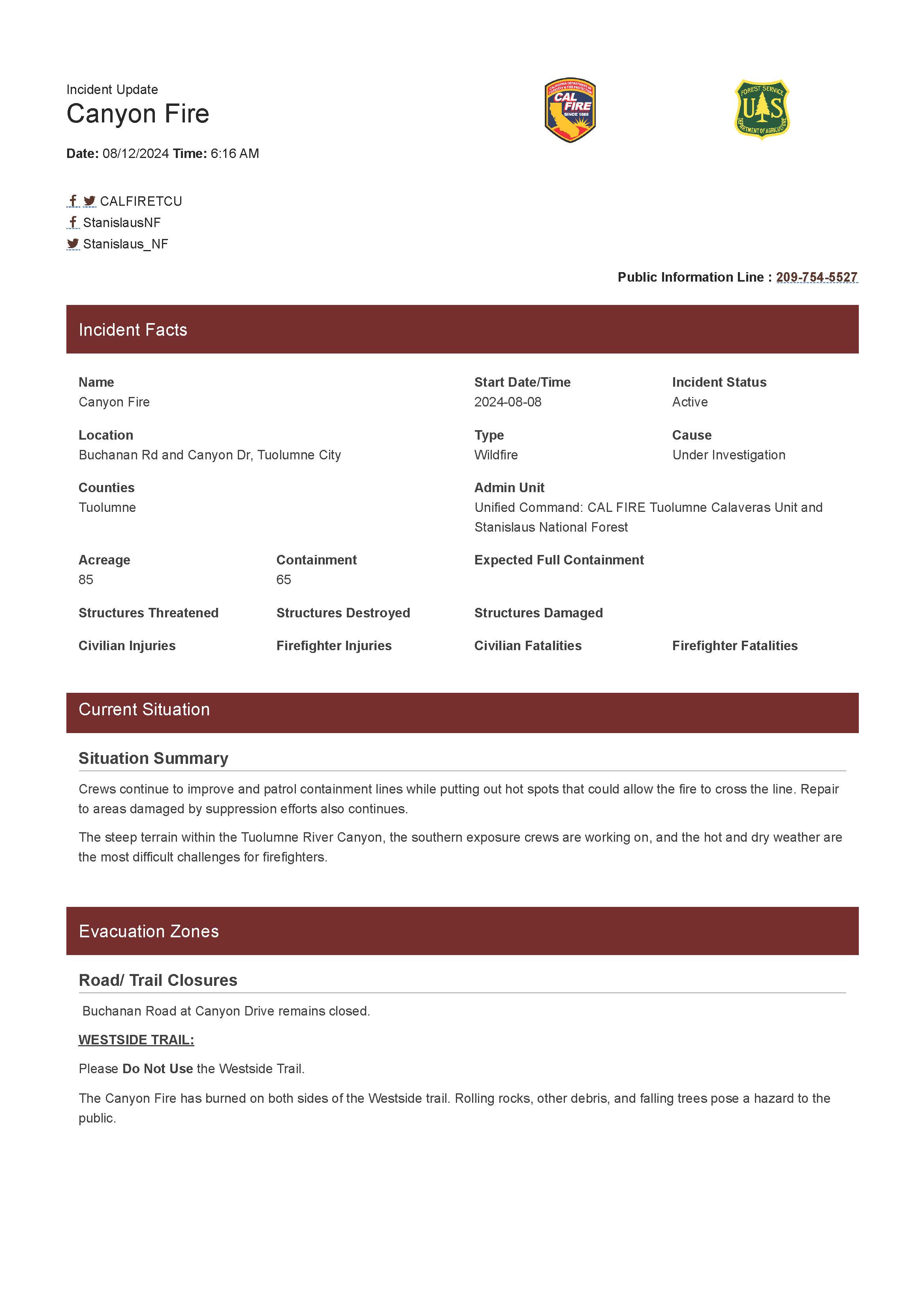
Canyon Fire Update 08 12 2024
Related Incident: Canyon Fire
Publication Type: News
Crews continue to improve and patrol containment lines while putting out hot spots that could allow the fire to cross the line. Repair to areas damaged by suppression efforts also continues.
The steep terrain within the Tuolumne River Canyon, the southern exposure crews are working on, and the hot and dry weather are the most difficult challenges for firefighters.