
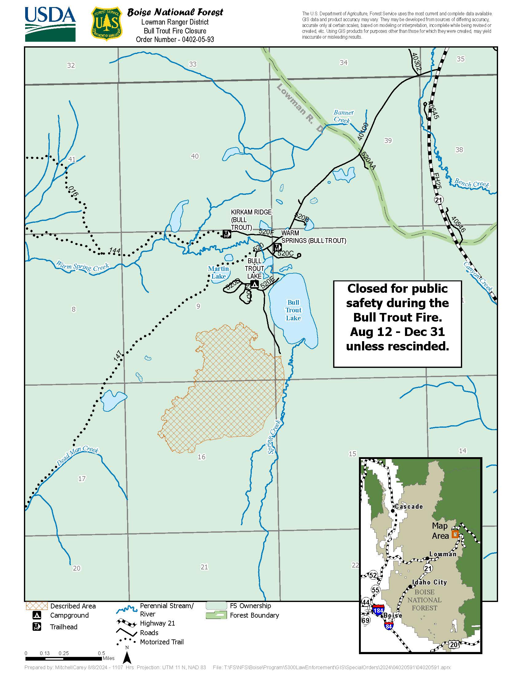
Closure Order for the Bull Trout Fire Area 08 12 2024
Related Incident: Bulltrout Fire
Publication Type: Closures
BOISE, Idaho, Aug. 12, 2024 – The Boise National Forest has modified or expanding their wildfire closures to address public and firefighter safety and respond to increased wildfire growth. Changes became effective earlier today.
Please refer to the maps and closure orders on the Boise National Forest’s Alerts and Notices webpage and Interactive Forest Closure Map for specific details.
Due to successful firefighting efforts, the closure area is being reduced to the existing fire perimeter. Bulltrout Campground is now open, though the first-come, first-served campsites 11-15 are closed due to fire equipment.
Easy Fire Update 08 12 2024
Related Incident: Easy Fire
Publication Type: News
Easy Fire Daily Update
August 12, 2024
Quick Facts
Size: 2130 acres | Start Date: July 17, 2024 | Location: 17 miles west of Mazama, WA | Containment: 0% Cause: Lightning | Resources Assigned: 237
CURRENT SITUATION: At approximately 8:30 p.m. last night, after receiving nearly two inches of rain, a large mudslide occurred on the western side of the Easy fire near mile marker 152 of State Route 20. The Washington Department of Transportation (WSDOT) estimates that it will take approximately two days to remove the debris off State Route 20. However, due to continued hazards related to the Easy Fire, highway 20 will continue to be closed to public transportation until announced otherwise.
TODAY: Because of recent and expected forecasted rainfall, crews will be assessing ways to safely engage with fire suppression activities. The Team will also continue to evaluate suppression options that account for moderated weather conditions. The plan continues to hold the fire at the ridgetop between Okanagon and Skagit County.
WEATHER AND SMOKE: Overnight, thunderstorms with heavy rainfall impacted the Easy Fire. Today will be cooler today but remain unsettled, with a renewed threat of showers and thunderstorms by this afternoon. Drier conditions return on Tuesday with the chances of showers lowering to below 20 percent. Also, the marine layer will approach the fire area and bring higher humidity and cooler temperatures. Winds today and tomorrow will largely be from the northwest with speeds of 6 to 10 mph and gusts around 15 mph.
For today, there is more certainty of increased smoke to communities southeast of the Easy and Pioneer fires in the lower Lake Chelan and Entiat areas. In these areas, expect moderate air quality in the morning to decrease to Unhealthy for Sensitive Groups in the evening and overnight. Overall air quality in the Stehekin Valley will be at unhealthy, while the Newhalem area and Methow Valley communities will have overall Moderate air quality.Read full smoke report: https://outlooks.airfire.org/outlook/f79a6d6d
CLOSURES: State Route 20 is closed in both directions between Granite Creek (MP 148) and Rainy Pass (MP 157): https://wsdot.com/Travel/Real-time/Map/. State Route 20 will remain closed through the weekend as crews continue working to mitigate hazards. Washington Department of Transportation will reevaluate conditions on Monday August 12, 2024. The Okanogan-Wenatchee National Forest has closures in place for trails within the fire area: https://bit.ly/EasyFireClosures. This closure includes a portion of the Pacific Crest Trail. Campfires are prohibited. There is a Temporary Flight Restriction (TFR) in place over the fire: https://tfr.faa.gov/save_pages/detail_4_6779.html. Unauthorized drone activity is prohibited under the TFR.
EVACUATIONS: There are no evacuations in place for the Easy Fire. Visitors recreating in the area should be vigilant of surroundings and stay out of closed areas.
InciWeb: https://inciweb.wildfire.gov/incident-information/waowf-easy-fire
Facebook: https://www.facebook.com/profile.php?id=61560760893080
Fire Information Line: 541-861-5808, 8 AM to 8 PM
Email: 2024.easy@firenet.gov
Town Gulch Fire Daily Update 08 12 2024
Related Incident: Town Gulch
Publication Type: News
Town Gulch Fire Daily Update
Monday, August 12, 2024
Fire Information: 541-208-7092, 8 a.m. to 8 p.m.
Town Gulch Fire Facebook: tinyurl.com/ycypw2bt
Email: 2024.TownGulch@firenet.gov
Linktree: linktr.ee/TownGulchFire
Size: 18,161 acres (391 reduction) Cause: Lightning
Containment: 37 percent Start Date: August 5, 2024
Total Personnel: 296 Structures Damaged or Destroyed: 4
RED FLAG CONDITIONS: Red Flag Conditions are expected Monday night into early Tuesday due to dry thunderstorms. Lightning without accompanying rain and outflow winds up to 40 mph are possible after 10:00 PM tonight. A Red Flag Warning is issued by the National Weather Service (NWS) to alert the public, firefighters, and land management agencies that conditions are ideal for wildland fires to start and spread quickly.
CURRENT SITUATION: Today, crews will utilize water, heavy equipment and hand tools to improve line and create a cold, fuel free barrier up to 100’ within containment lines. Yesterday near China Spring, a hotshot crew completed over one half mile of handline to tie the secondary containment line into a road. Firefighters will patrol and monitor the west, south and east sides of the fire. The focus is to extinguish all hotspots within 50’ of containment lines. On the west side of the fire, resources are focused on keeping the fire out of timber stringers located in creek drainages. These dense pockets of fuel often involve tree torching and spotting if ignited. A network of firehose, pumps and water tanks will aid in this effort.
The size of the fire has been reduced by 391 acres as a result of more accurate mapping.
WEATHER: The weather will be hot and dry once again today, with a high near 90 degrees. Relative humidity will drop to about 20% today. Winds are expected to be light and mainly terrain-driven throughout the day. High temperatures will drop to the high 70s/low 80s on Tuesday due to the storm system moving into the area. Humidity is showing good recovery at night, climbing into the low to mid 50 percent. As unburned fuels within the fire perimeter continue to ignite, smoke will impact local air quality. Today’s air quality in the area is rated as moderate. Current air quality information is available on the Oregon smoke blog (https://www.oregonsmoke.org/).
CLOSURES: Wallowa-Whitman National Forest lands, roads, trails, and recreation sites around the Town Gulch Fire are temporarily closed and fire restrictions are in effect. Forest closure orders and maps can be found on the Forest’s “Forest Orders” web page: tinyurl.com/36t4f2t2.
EVACUATIONS: Baker County Sheriff’s Office has issued Level 1, 2, and 3 evacuations for areas near the fire. Follow the sheriff’s office Facebook page (tinyurl.com/3auvka4j) for the latest evacuation news. Residents may sign up to receive emergency notifications through Baker County ALERT (tinyurl.com/884czdrf).
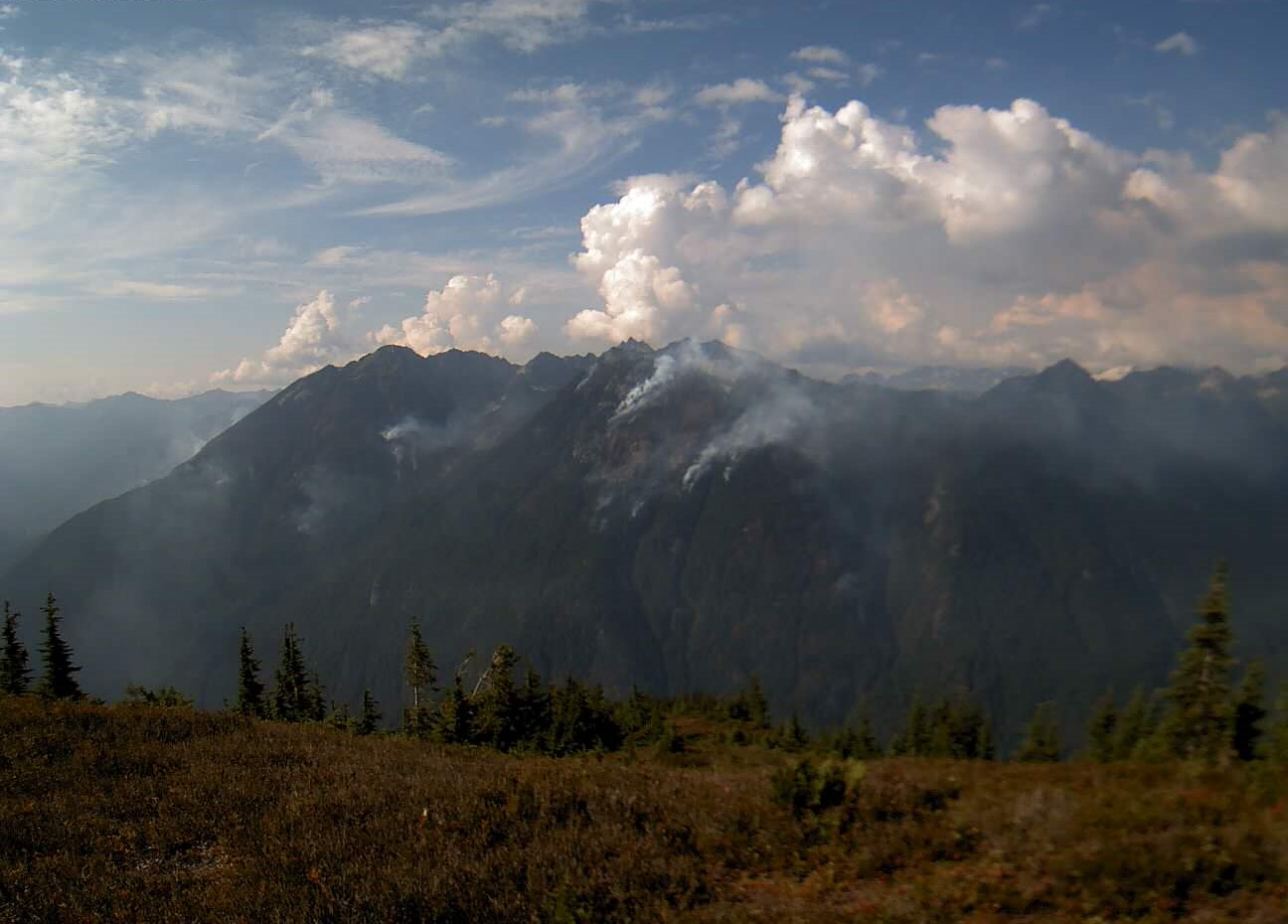
Miners Complex Daily Update 08 12 2024
Related Incident: Miners Complex Fires
Publication Type: Announcement
11:00 AM, August 12, 2024
Estimated size: 1,098 acres
Start Date/Time: July 17, 2024
Area of Origin: 21 air miles east of Darrington WA
Cause: Lightning
Fuels/Topography: timber, rugged terrain
Structures Damaged: None, there are no homes threatened at this time.
Evacuations: None
The Miners Complex consists of ten wildfires caused by lightning strikes in the Mt. Baker-Snoqualmie National Forest. The fires included in the complex are: Miners Fire, Vista Ridge Fire, Dolly Creek Fire, Sulphur Three Fire, Sulphur Four Fire, Sulphur Thirty-Four Fire, Upper Sulphur Thirty-Two Fire, Lower Sulphur Thirty-Two Fire, Plummer, and Middle Ridge Fire.
Update: The cooler weather yesterday resulted in minimal fire growth, and firefighters patrolled the Suiattle River Road. Today, firefighters will continue to monitor and patrol the fire. An infrared flight occurred yesterday, showing that the Middle Ridge Fire has burned over a section of the Pacific Crest Trail, and the Sulphur fires have burned over a section of the Sulphur Mountain Trail. An increase in acreage is shown today, which occurred progressively during the warm, dry and windy weather last Thursday and Friday. The flight imaging also showed that several fires merged together during last week’s growth: the Sulphur Three and Sulphur Four fires have merged, and the Upper Sulphur Thirty-Two, Lower Sulphur Thirty-Two and Sulphur Thirty-Four fires have merged.
Weather: Thunderstorm chances continue for the North Cascades today and mainly near the crest on Tuesday. Troughing over the region will promote cooler temperatures, onshore flow, and good relative humidities. Max temperatures around 66 degrees. Light winds becoming west 5 to 6 mph in the afternoon. Gusty and erratic winds expected near thunderstorms in the afternoon.
Smoke: For more information on smoke and air quality please visit: https://wasmoke.blogspot.com/
Closures: The following is a summary of the areas closed due to the fires in the Miners Complex. Pacific Crest National Scenic Trail #2000.2 from Mica Lake to Suiattle Pass, Suiattle River Trail #784, Miners Ridge Trail #785, Buck Creek Pass Trail #789, Miners Cabin Trail #795, Grassy Point Trail #788, Sulphur Mountain Trail #794, Sulphur Creek Trail #793, Sulphur Creek Campground, Sulphur Creek Trailhead, and the Downey Creek trailhead. The full Closure Orders visit: https://www.fs.usda.gov/mbs
Forest Restrictions: The Mt. Baker-Snoqualmie has a full campfire ban and forest-wide shooting restrictions in place to help prevent human-caused starts during this period of unprecedented resource scarcity. Additional details at: www.fs.usda.gov/mbs
###
Boise Fire Update August 12 2024 08 12 2024
Related Incident: 2024 Boise Fire
Publication Type: News
Headlines
- Join us TODAY for an ask the Incident Commander Q&A session LIVE on the Boise Fire Facebook at 2:00 p.m.
- Get all your Boise Fire information in one mobile-friendly place! https://linktr.ee/2024boisefiresrf
- Evacuations are in place for the Boise Fire for residents near the fire area in Humboldt County. For more the most current evacuation information please visit the Boise Fire linktree or visit--
- Humboldt County: https://humboldtgov.org/356/Office-of-Emergency-Services
- Siskiyou County: https://www.co.siskiyou.ca.us/emergencyservices
Quick Facts
- Acres: 1,621 (no infrared flown overnight, but also little growth observed.)
- Detection Date: August 9, 2024
- Containment: 0%
- Cause: Under investigation
- Crews: 8
- Engines: 10
- Dozers: 2
- Helicopters: 7
- Fixed wing: available as needed
Leader’s Intent: The Boise Fire is being managed with a full suppression strategy.
Operational Update: Crews have been working along roads where possible near Short Ranch and on Le Perron Flat to create containment lines as close to the fires edge as possible to protect the private property in those areas. A structure group is in place to provide structure defense, should it become necessary. Firefighters are looking to open containment lines from the 2020 Red Salmon Fire on the southern side of the Boise Fire and to the east along the Orleans Look out Road/ Antennae Ridge.
Weather and Fire Behavior: The weather today is anticipated to continue to trend slightly cooler, with good humidity recoveries observed overnight, although less of an inversion than predicted. A very slim chance of thunderstorms over northeastern Trinity County is forecasted for today. The fire is currently aligned with several drainages with very heavy vegetation loading. This could result in active fire behavior.
Pioneer Fire Update 08 12 2024
Related Incident:
Publication Type: News
Pioneer Fire Daily Update
August 12, 2024
Quick Facts
Size: 38,299 Start Date: June 11, 2024 Location: 31 miles NW of Chelan, WA
Containment: 13 percent Personnel: 649 Cause: Human-caused, under investigation
CURRENT SITUATION: A Red Flag Warning will be in effect until 12:00 P.M. for abundant lighting and thunderstorms in and around the fire area. The weather will determine the focus of today’s firefighting efforts. Firefighter and public safety continues to be the incident’s number one priority. When necessary, firefighters will take a tactical pause until conditions allow resumption of suppression efforts. Crews assigned to the incident continue to respond to multiple new fires caused by recent the thunderstorms. Initial attack crews and aviation resources will respond to all new fires with an aggressive initial attack strategy.
On the evening of August 10 firefighters responded to a lightning caused fire in the area of safety harbor. The two-acre fire immediately had hose line put in around it and was suppressed. There is currently no heat or smoke coming from the area.
TODAY’S ACTIVITIES: Today fire resources will continue structure protection and road preparation efforts along the Stehekin Valley road. As weather permits, firefighters will take advantage of moderating fire activity and construct direct handline along the Boulder ridge to stop the northern progression of the fire.
WEATHER AND SMOKE: There were scattered thunderstorms that impacted the Pioneer fire last night and this morning. Temperatures will be cooler today but remain unsettled with a 30 percent chance for showers and thunderstorms in the afternoon. Winds will start off light then become gusty from the northwest, especially along Lake Chelan. Temperatures will continue to cool into Tuesday with high temperatures in the upper 70s to lower 80s with drier conditions. Winds will remain breezy from the northwest with gusts of 20 to 25 mph possible in the late afternoon into evening hours.
For Monday, expect increased smoke to communities southeast of the Easy and Pioneer fires in the lower Lake Chelan and Entiat areas. In these areas, there will be Moderate air quality in the morning , decreasing to Unhealthy for Sensitive Groups in the evening and overnight. Overall air quality in the Stehekin Valley will be at Unhealthy, while the Newhalem area and Methow Valley communities will have overall Moderate air quality. Read the full report https://outlooks.airfire.org/outlook/f79a6d6d.
EVACUATIONS: Level 1, 2 and 3 evacuation levels remain in effect around the Pioneer Fire. Please contact Chelan County Emergency Management or visit https://t.ly/QoH9w for more information.
FOREST CLOSURE: Closures for the North Cascades National Park: https://www.nps.gov/noca/index.htm
The Okanogan-Wenatchee National Forest has a closure order in place for much of the fire area: Okanogan-Wenatchee National Forest - Alerts & Closures (usda.gov). Campfires are prohibited. There is a Temporary Flight Restriction (TFR) in place over the fire: https://tfr.faa.gov/save_pages/detail_4_6779.html. Unauthorized drone activity is prohibited under the TFR.
InciWeb: https://inciweb.wildfire.gov/incident-information/wases-pioneer
Facebook: https://www.facebook.com/profile.php?id=61560760893080
Fire Information Line: 541-861-5808, 8 AM to 8 PM
Email: 2024.pioneer@firenet.gov
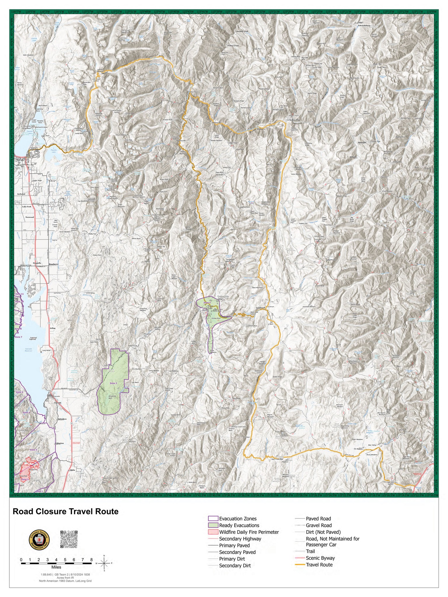
Warm Lake Highway CLOSED Due To Snag Fire 08 12 2024
Related Incident:
Publication Type: Closures
FOR IMMEDIATE RELEASE
August 12, 2024
WARM LAKE HIGHWAY CLOSED DUE TO SNAG FIRE
CASCADE, Idaho- The Valley County Sheriff’s Office has closed Warm Lake Highway due to the Snag Fire. The Warm Lake Highway is closed at the Horsethief Road intersection east toward Warm Lake and from the Johnson Creek Road intersection west toward Warm Lake. Scott Valley residents will be allowed access.
Anyone currently planning to exit via the Warm Lake Highway will need to use an alternate evacuation route if it becomes necessary to leave the area. Please refer to the attached map for safe routes (noted in yellow). A “ready” evacuation order remains in place for those in Zone 1 around Warm Lake and Zone 2 around Horsethief Reservoir.
The Snag Fire remained active yesterday, August 11, 2024, and is now within 500 feet of the Warm Lake Highway. For current information on the Snag Fire, please visit https://inciweb.wildfire.gov/incident.../idbof-snag-fire.
……
For tips on how to prepare for a fire evacuation, please visit https://www.co.valley.id.us/departments/Wildfire/ReadySetGo
For timely information on evacuations, be sure to sign up for CODE RED alerts at https://www.co.valley.id.us/CompleteEmergencyNotificationandAlerting
Pincer Two Fire Daily Update 08 12 2024
Related Incident: Pincer Two Fire
Publication Type: Announcement
11:00 AM, August 12, 2024
Estimated size: 189 acres
Start Date/Time: July 17, 2024
Area of Origin: Johannesburg Mountain. 1 Mile East of Mineral Park C.G.
Cause: Lightning
Fuels/Topography: Timber, rugged terrain
Structures Damaged: None, there are no homes threatened at this time.
Evacuations: None
Closures: Cascade River Road at and including Marble Creek Campground, Mineral Park Campground, and all tributary roads, trailheads, and trails are all closed. The public is not to enter the area for public and firefighter safety.
Full closure orders available at: https://www.fs.usda.gov/mbs
Update: The fire continued to have minimal growth and hold 50’ from the Cascade River Road, besides one small segment that traveled down to the road through dead and downed trees. Firefighters successfully installed hose lines along Forest Road 1590 road to prepare for the possibility of the fire moving further down the hill. An infrared flight occurred yesterday, showing a slight increase in acreage, most of which occurred last Thursday and Friday with the warm, dry weather. Today, firefighters continue monitoring and patrolling along the Cascade River Road and the 1590 road.
Weather: Thunderstorm chances continue for the North Cascades today and mainly near the crest on Tuesday. Troughing over the region will promote cooler temperatures, onshore flow, and good relative humidities. Mostly cloudy (65-75 percent). Chance of rain showers and slight chance of thunderstorms in the afternoon. Max temperatures around 66. Light winds becoming west 5 to 6 mph in the afternoon. Gusty and erratic winds expected near thunderstorms in the afternoon.
Smoke: For more information on smoke and air quality please visit: https://wasmoke.blogspot.com/
Air Space Restrictions: There are no air space restrictions at this time.
Forest Restrictions: The Mt. Baker-Snoqualmie has a full campfire ban and forest-wide shooting restrictions in place to help prevent human-caused starts during this period of unprecedented resource scarcity. Additional details at: www.fs.usda.gov/mbs
###
Hwy 90 is open 25 Mesa Rd Opening 8PM on 08 12 2024
Related Incident: Bucktail Fire
Publication Type: Closures
Highway 90 is open to through traffic. While the area closure remains in effect, at 8:00p.m. today, August 12, 2024, the 25 Mesa Road will also open to through traffic. There are active operations on this road with crews and heavy equipment, such as excavators. Please stay alert. The roads and trails north of Highway 90 in the fire area remain closed. Authorities will continue to evaluate road conditions in the affected area to determine the best approach for reopening other roads in the future.