
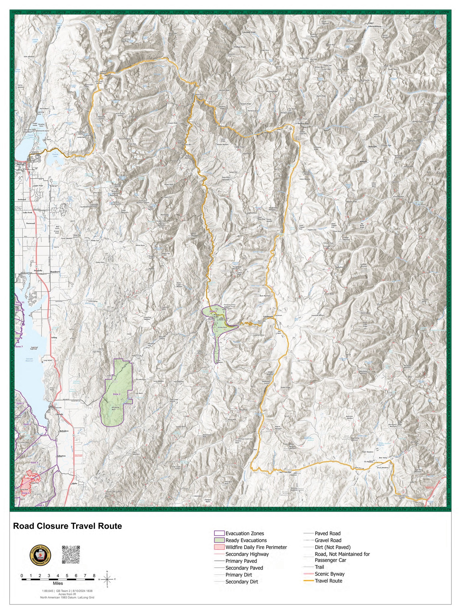
Warm Lake Highway CLOSED Due To Snag Fire 08 12 2024
Related Incident:
Publication Type: Announcement
FOR IMMEDIATE RELEASE
August 12, 2024
WARM LAKE HIGHWAY CLOSED DUE TO SNAG FIRE
CASCADE, Idaho- The Valley County Sheriff’s Office has closed Warm Lake Highway due to the Snag Fire. The Warm Lake Highway is closed at the Horsethief Road intersection east toward Warm Lake and from the Johnson Creek Road intersection west toward Warm Lake. Scott Valley residents will be allowed access.
Anyone currently planning to exit via the Warm Lake Highway will need to use an alternate evacuation route if it becomes necessary to leave the area. Please refer to the attached map for safe routes (noted in yellow). A “ready” evacuation order remains in place for those in Zone 1 around Warm Lake and Zone 2 around Horsethief Reservoir.
The Snag Fire remained active yesterday, August 11, 2024, and is now within 500 feet of the Warm Lake Highway. For current information on the Snag Fire, please visit https://inciweb.wildfire.gov/incident.../idbof-snag-fire.
……
For tips on how to prepare for a fire evacuation, please visit https://www.co.valley.id.us/departments/Wildfire/ReadySetGo
For timely information on evacuations, be sure to sign up for CODE RED alerts at https://www.co.valley.id.us/CompleteEmergencyNotificationandAlerting
Bucktail Fire Update 08 12 2024
Related Incident: Bucktail Fire
Publication Type: News
NEWS RELEASE
For Immediate Release
Media Contact:
Public Information Officer, Amy Ricotta, 970-823-4060
Bucktail Fire Update – August 12, 2024, 11:00 a.m.
Nucla, Colorado
Start Date: August 1, 2024
Cause: Unknown
Size: 7,202 acres
Percent Contained: 67%
Resources Assigned: 110 personnel
Crews (2); Engines (4); Water tenders (1); Air Resources (1); Heavy Equipment (4)
Yesterday: The fire area stayed within its current footprint and rainfall helped reduce the fire intensity within the interior. Crews continued to secure containment lines. Firefighters transitioned from active suppression to repair and patrolling activities. Suppression repair efforts occurred with crews using heavy equipment and hand tools to return impacts caused by firefighting activities to a more natural state. Some firefighters were reassigned to other wildfires in the nation needing support.
Today: Firefighters continue cleaning up, patrolling and monitoring the fire perimeter. Suppression repair work is being carried out to address and restore areas impacted by firefighting operations. While the number of personnel on the fire will continue to decrease significantly over the next couple days, resources will remain on scene to monitor the fire perimeter.
Highway 90 is open to through traffic. While the area closure remains in effect, at 8:00p.m. today, August 12, 2024, the 25 Mesa Road will also open to through traffic. There are active operations on this road with crews and heavy equipment, such as excavators. Please stay alert. The roads and trails north of Highway 90 in the fire area remain closed. Authorities will continue to evaluate road conditions in the affected area to determine the best approach for reopening other roads in the future.
Weather: Lingering showers are possible Monday morning. Scattered showers and thunderstorms redevelop over the higher terrain Monday afternoon. Storms will be capable of producing gusty winds to 40mph. Today’s temperatures will range from 76-81 degrees Fahrenheit while relative humidity will be 40-45%.
Evacuations: None.
Closures: While the area closure remains in effect, Highway 90 is open to through traffic. At 8:00p.m. August 12, 2024, the 25 Mesa Road will open to through traffic. The roads and trails north of Highway 90 in the fire area remain closed.
Road and area closures are in place within the proximity of the fire for public and firefighter safety. This includes 25 Mesa Road to the northwest, as well as Houser Road, Cottonwood Trail, and Hwy 90 to the south. The closure area also includes all roads and trails within this boundary. For a complete list of closed roads and a map of the closure area, please visit: https://inciweb.wildfire.gov/incident-information/coupd-bucktail-fire.
The BLM temporary Emergency Closure Order and map are posted to the BLM Southwest District Fire page under Current Fire Restrictions & Notices / Uncompahgre Field Office at: https://www.blm.gov/programs/public-safety-and-fire/fire-and-aviation/regional-information/colorado/southwest-district.
The Forest Service temporary Emergency Closure Order and map are posted on the Forest Service Website at: fs.usda.gov/Internet/FSE_DOCUMENTS/fseprd1198456.pdf.
A Temporary Flight Restriction (TFR) is in place over the fire area. Wildfires are a No Drone Zone. If You Fly, We Can’t: https://knowbeforeyoufly.org/home
Smoke Information: Visit CDPHE - Colorado.gov/AirQuality to learn about protecting yourself from wildfire smoke. For more information on current air quality go to Fire and Smoke Map (airnow.gov) and zoom in on Southwest Colorado.
Fire Prevention: Fire managers would like to remind everyone to be attentive to their actions and surroundings, especially in areas with dry vegetation or dead/down trees. Preventing new fires is the most important thing anyone can do to help firefighters. Practice smart wildfire prevention behavior including never leaving a campfire unattended, and ensuring fires are completely out and cold. Make sure trailer chains don’t drag and dispose of smoking materials properly. Every spark can start a fire!
For additional information:
Montrose County Sheriff’s Office: https://montrosecountysheriffsoffice.com/bucktail-fire
Colorado Division of Fire Prevention and Control: https://dfpc.colorado.gov
Bureau of Land Management Southwest Colorado District, Uncompahgre Field Office: https://www.facebook.com/BLMMontroseFireUnit
West Slope Fire Information website: www.WestSlopeFireInfo.com
GMUG Fire Information https://www.facebook.com/GMUGFireInfo
Road Closures Montrose County: https://www.facebook.com/MontroseCountySO
Bucktail Fire Information Hotline: (970) 823-4060
Community Meeting at Lowman Emergency Services Station 80 on 8132024 08 12 2024
Related Incident: Bulltrout Fire
Publication Type: Announcement
Join us for a Middle Fork Complex, Bulltrout, and Wapiti Fire Community Meeting Tuesday, August 13, 2024, at 7pm for an in-person explanation of current fire activity and planned actions on these fires. The Community Meeting will be located at the Lowman Emergency Services Station 80, at 8000 HWY 21, Lowman, ID.
Crazy Creek Fire Daily Update for August 12 2024 08 12 2024
Related Incident: Crazy Creek
Publication Type: News
Interior burning increases Crazy Creek Fire acreage; spot fires extinguished over northeast perimeter
Daily Update August 12, 2024
Fire Information Phone: 541-208-1768 (8 a.m.-8 p.m.)
Email: 2024.crazycreek@firenet.gov
Acres*: Crazy Creek – 84,512; 60% contained
Kitty Creek – 73; 100% contained
*Acreage changes may occur due to overnight operations and infrared mapping.
Location: Crazy Creek: 5 miles north of Paulina, Oregon; 498/Kitty Creek: 7 miles south of Mitchell, Oregon
Start Date: July 22, 2024 Personnel: 699
Resources: 19 crews | 1 helicopter | 36 engines | 13 bulldozers | 19 water tenders | 3 masticators | 27 skid steers
Highlights: The Crazy Creek Fire’s perimeter was unchanged today. The total acres burned increased by 2,233 acres from Sunday to a total of 84,512 acres today. Containment also stayed at 60 percent. The increased acreage was attributed to successful firing operations and pockets of vegetation that burned inside the fire perimeter. The northeast edge of the fire has the focus of the team, and crews were shifted to address the hottest areas around Little Summit as well as Wolf and East Wolf Creeks.
Daytime winds out of the southwest did blow embers over the northeastern perimeter, resulting in sporadic spot fires. Firefighters were able to quickly extinguish them, and overnight infrared monitoring did not reveal any additional heat outside the fire perimeter.
Firefighters will focus on patrolling established containment lines and extinguishing isolated hot spots within the fire’s interior. Daytime winds out of the southwest and pockets of unburned vegetation near the northeast perimeter will again be a cause for concern for that section of the fire.
Evacuations: Evacuation orders remain in effect for areas in Crook and Wheeler Counties for areas in or near the fire. Level 3 evacuations have extended from the Forest Boundary to Highway 380. Level 2 evacuations have extended south of Highway 380. For further information, please refer to the Crook County Office of Emergency Management evacuation map.
Weather: Today and into next week hot, dry weather will persist throughout the area with temperatures in the high 80s to low 90s, light winds gusting to 21 mph and low humidity.
Importance of Fire Prevention: All public lands in Central Oregon, including the Ochoco National Forest, are in Stage 2 Public Use (Fire) Restrictions. All open flames, including woodstoves and charcoal briquette fires, are prohibited. In times of high fire danger, it is crucial for everyone to follow prevention measures to avoid additional strain on overburdened resources.
Fire Restrictions and Closures: The Ochoco National Forest has implemented a forest closure for the Paulina Ranger District. The Bureau of Land Management has issued a temporary closure for public lands in Crook and Grant Counties.
More Information:
InciWeb: https://inciweb.wildfire.gov/incident-information/orocf-crazy-creek
Facebook: Facebook.com/Crazy Creek Fire
Central Oregon Wildfire Information: https://centraloregonfire.org/
Crook County Emergency Information Map: https://arcg.is/1ij0vb
Community Meeting at Lowman Emergency Services Station 80 on 8132024 08 12 2024
Related Incident:
Publication Type: Announcement
Join us for a Middle Fork Complex, Bulltrout, and Wapiti Fire Community Meeting Tuesday, August 13, 2024, at 7pm for an in-person explanation of current fire activity and planned actions on these fires. The Community Meeting will be located at the Lowman Emergency Services Station 80, at 8000 HWY 21, Lowman, ID.
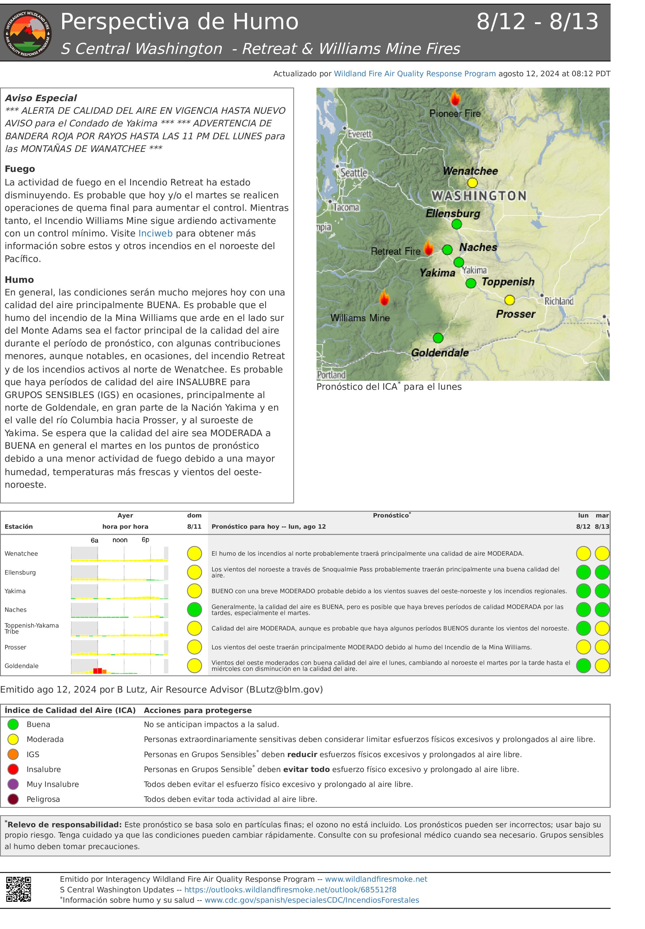
Actualizacin Matutina del Incendio Retreat 12 de Agosto 08 12 2024
Related Incident: Retreat
Publication Type: News
Actualización Matutina del Incendio Retreat - 12 de Agosto
Información sobre incendios: 509-213-4890, de 8 a.m. a 8 p.m.
Correo electrónico 2024.Retreat@firenet.gov
Linktree: linktr.ee/CIIMT14
Acres totales: 45.601 acres Contención: 70% Cantidad de personal: 412
Situación actual: La actividad del fuego continuó moderándose ayer mientras que los bomberos hicieron grandes progresos en la ampliación de la contención en el Retreat Fire. El Equipo 14 de Gestión de Incidentes Complejos de California está gestionando el incendio de Retreat con una estrategia de extinción total, dando prioridad a la seguridad pública y de los bomberos.
El corredor de la autopista 12 permanece cerrado a la circulación pública por seguridad de los bomberos y del público.
Los grandes árboles debilitados por el fuego siguen suponiendo un riesgo de caída sobre la autopista en momentos inesperados. A lo largo del corredor de la autopista sigue habiendo focos humeantes y se espera que permanezcan varios días más.
Los bomberos siguen centrándose en asegurar las líneas de control para garantizar que no haya calor ni fuego que amenace la línea. Las fuentes de calor aisladas se extinguirán donde sea seguro introducir a los bomberos. Las cuadrillas de equipos pesados han construido el corte de combustible sombreado hasta el punto en que es seguro hacerlo con equipos. Se están insertando cuadrillas de bomberos cerca de las carreteras forestales 1200 y 1201 para continuar trabajando y completando el corte de combustible sombreado. El cortafuegos sombreado será una línea de control alternativa para proteger las estructuras de la zona del lago Rimrock. Los bomberos seguirán patrullando las zonas de Camp Ghormley, Lost Lake Road y el corredor de la autopista 12.
Los bomberos y los organismos locales han empezado a determinar la necesidad de realizar obras de reparación para la extinción de incendios y elaborarán un plan para completarlas en las próximas semanas.
Tiempo: Aire estable fresco y húmedo sobrevoló las Cascadas. Esto mantendrá la humedad alta y las temperaturas más frescas. También continúa el flujo constante del noroeste sobre la región. Las temperaturas seguirán bajando durante los próximos días.
Evacuaciones: Para obtener la información más actualizada sobre evacuaciones, visite el sitio web de Administración de Emergencias del Condado de Yakima en yakimacounty.us/350.
Cierres por incendio:
- La US Highway 12 permanece cerrada entre la Y de la Highway 410 y la cima del puerto en el punto kilométrico 151.
- Okanogan-Wenatchee National Forest Retreat Fire Closure(tinyurl.com/5ext5aec).
- La Región Sureste del Departamento de Recursos Naturales del Estado de Washington (DNR) ha cerrado temporalmente parte del Bosque Estatal de Ahtanum. El público puede acceder a la información más actualizada sobre el cierre en dnr.wa.gov/ahtanum.
- El Departamento de Pesca y Vida Silvestre de Washington ha cerrado al acceso público la mayor parte de la zona silvestre de Oak Creek debido al incendio Retreat Fire hasta el 23 de agosto de 2024. Más información en tinyurl.com/bdet7845.
Calidad del aire y humo: Las perspectivas sobre la calidad del aire y el humo pueden consultarse en airnow.gov.
Ruby Fire Daily Update and Map 08 12 2024
Related Incident: Ruby Fire
Publication Type: News
Ruby Fire Update-August 12th, 2024
Minnesota Incident Command System (MNICS) Incident Commander-Jeb Backe
Size: 739 acres Location: North Cascades National Park, Ruby Mountain, Diablo, Washington
Containment: 0% Cause: Lightning/Natural
Start Date: August 9th, 2024 Total Personnel: 69
Fire Information:
Inciweb: https://inciweb.wildfire.gov/incident-information/wancp-ruby-fire Email: 2024.Ruby@firenet.gov
Facebook: https://www.facebook.com/people/Ruby-Fire/61563760546137/ Phone: 1-360-208-8096
Operations: Minnesota Incident Command took command of the fire at 6 am today.
Current Status: The fire was calmer yesterday morning but as the temperature increased and humidity decreased it grew exponentially, following the pattern of the past few days. Firefighters are working to minimize the impact of the fire on nearby infrastructure and natural resources. Access to the fire has been difficult due to the steep terrain and numerous hazards. The Baker River Hotshots and other firefighters are working to protect bridges, cabins, and other structures between Thunder Creek and Stillwell Creek.
Additional resources will be brought in as they become available.
Weather: National Weather Forecast - A 40 percent chance of showers and thunderstorms, mainly between noon and 5pm. Widespread haze between 10 am. and noon. Areas of smoke before 10 a.m., then areas of smoke after noon. Partly sunny, with a high near 56. West wind 5 to 8 mph.
Closures: There are multiple closures in the area due to the Ruby Fire and other nearby fires. Colonial Creek South Campground and boat launch are closed. For a full list of park closures visit
https://go.nps.gov/fireclosures Cascade River Road is closed at MP8. State Route 20 is closed east of the park from MP 148 and MP 157 due to the Easy Fire.
Burning Restrictions: National Park Service - Campfires or the ignition of wood, briquettes, or any fuel in fire pits, fire pans and barbeque grills, are banned in all portions of North Cascades National Park Service Complex – North Cascades National Park, Ross Lake National Recreation Area, and Lake Chelan National Recreation Area. This includes all National Park Service lands and campgrounds along State Route 20 as well as Hozomeen and the entire Stehekin Valley.
Cooperating Agencies & Tribes: National Park Service, Seattle City Light, Upper Skagit Indian Tribe, Whatcom County, Whatcom County Sheriff’s Office
Smoke: U.S. Interagency Wildland Fire Air Quality Response Program - Overall air quality will be MODERATE today in upper Skagit Valley.
https://outlooks.wildlandfiresmoke.net/outlook/f79a6d6d https://www.airnow.gov/
If you would like to sign up for our daily updates, please send an email to: 2024.Ruby@firenet.gov
Middle Fork Complex Wapiti and Bulltrout Daily Update 081224 08 12 2024
Related Incident: Bulltrout Fire
Publication Type: News
Incident Commander: Rick Connell, Northern Rockies Team 5
Middle Fork Complex Location: 9 miles east of Garden Valley, ID
Bulltrout Location: 15 miles WNW OF Stanley, ID Wapiti Location: 2 miles southwest of Grandjean, ID
Start Dates: 07/24/24 – 08/06/2024
Cause: Lightning
Size:
Bulltrout: 271 acres Wapiti: 2452 acres
Middle Fork Complex: Bulldog: 1771 acres Anderson: 1594 acres Nellie: 1104 acres
Containment: Middle Fork Complex: 1% Bulltrout: 75% Wapiti: 0%
Resources on site:
Middle Fork Complex: 1 hotshot crew; 5 type 2 hand crew; 9 engines; 3 bulldozers; 3 water tenders
Wapiti: 1 type 2 hand crew; 3 engines
Bulltrout: 1 engine
Total Personnel: Middle Fork Complex: 296 Bulltrout:18 Wapiti: 52
KEY MESSAGE:
Join us for a Middle Fork Complex, Bulltrout, and Wapiti Fire Community Meeting Tuesday, August 13, 2024, at 7pm for an in-person explanation of current fire activity and planned actions on these fires. The Community Meeting will be located at the Lowman Emergency Services Station 80, at 8000 HWY 21, Lowman, ID.
CURRENT STATUS/PLANNED ACTIONS:
Middle Fork Complex: The Middle Fork Complex is comprised of Bulldog, Nellie, and Anderson fires. On the Bulldog Fire, firefighters continue to work along the Middlefork River Road thinning and trimming to remove flammable debris. Strategic overnight firing operations continue, and crews are securing the edges and holding the constructed control lines along the south side of the fire. Firefighters are working to protect private property and structures in the vicinity of Crouch.
The public is reminded that the Middle Fork Road is closed at the Forest Service boundary just south of Lightning Creek for firefighter and public safety. The Nellie and Anderson fires are burning in remote, rugged terrain. Yesterday activity on the fires increased due to changes in weather and crews continue to access opportunities to access the fire and lookout on Anderson. Crews plan to utilize a helicopter to conduct strategic firing operations today ahead of the fire in order to reduce fuels availability.
Wapiti Fire: Yesterday fire activity increased due to changes in weather and smoke was visible from State Highway 21 please use caution while driving in the area. Firefighters continue to ensure the structures in the vicinity of the fire are protected with improved defensible space, water pumps, and sprinklers. Firefighters are assessing the fire for opportunities to conduct strategic firing operations when conditions are favorable.
Bulltrout Fire: Crews will continue patrolling the fire area, repairing areas affected by suppression efforts, and extinguishing pockets of heat in the interior of the fire on the south side of the fire.
WEATHER AND FIRE BEHAVIOR:
Sunday a warm and dry air mass remained over the fire. As the inversion lifted, the temperatures increased, and relative humidity lowered. Today similar weather conditions are expected, with south/southwest terrain driven winds 5 mph and gusts between 10-12 mph. Fire activity will continue burning in timber and understory with group torching and become more active when the sky clears and inversions lift, specifically on ridgetops and areas exposed to winds.
CLOSURES, RESTRICTIONS, AND EVACUATIONS:
Middle Fork Complex: The Boise County Sheriff's Office continues to maintain the Level 2 evacuation notice for residents on and near the Middlefork Road between Stump Ranch Road up to Tie Creek Campground. The Boise National Forest issued areas closure for the fire area on August 8th (Closure #0402-06-58 and Closure # 0402-06-57).
Wapiti Fire: The evacuation order for Summer Homes and the Sawtooth Lodge remain in effect for the Wapiti Fire, as does the area closure issued by the Sawtooth and Boise National Forests (Closure #0402-05-92 effective July 27, 2024). This Order is for public and firefighter safety during fire suppression efforts of the Wapiti Fire.
Bulltrout Fire: The Bull Trout Fire Area Closure (0402-05-91) remains in effect for the roads, trails, and area surrounding the Bull Trout Fire. Boise National Forest issued this Order on July 27, 2024. It will be rescinded as soon as it is safe to do so.
Closure information and maps are posted on the Forests’ website and the fire’s Inciweb page as they are in place. https://tinyurl.com/2u8v3pf7
The Boise National Forest, Idaho Department of Lands, and Bureau of Land Management are in Stage 1 fire restrictions on state, endowment, private and federal lands within the West Central Mountains Fire Restrictions Zone. For more information on the restrictions and a map visit:
https://www.idl.idaho.gov/fire-management/fire-restrictions-finder/
Whisky Creek and Sandstone Fires Daily Update 08 12 2024
Related Incident: Whisky Creek FireSandstone Fire
Publication Type: News
Whisky Creek:
Size: 1,750 acres
Cause: Human – Under Investigation
Start Date: July 20, 2024
Location: 6 miles SE of Cascade Locks, OR
Fuels: Scrub oak, timber, and grass
Sandstone:
Size: 602 acres
Cause: Lightning
Start Date: Aug. 5, 2024
Location: 9 miles SW of Ripplebrook, OR
Fuels: Timber and grass
Whisky Creek Highlights:
Crews will continue to construct and improve the direct containment line on the north and east sides of the fire. Yesterday, crews started mop-up operations and today continued to secure, mop-up, and patrol along completed fire lines.
Sandstone Highlights:
Crews will continue building handline around Blister Creek Fire and securing the ridge. Mop-up continues along the handline east of the fire. There is a mix of handline and dozer line on the northeast portion of fire.
Operations:
Roads and ridges are being assessed for containment lines on the west and south flanks of the Sandstone Fire, while providing ground resources access to the fire. Equipment has begun building line along the southern area of the fire and crews will continue to put in indirect handline on the north portion of the fire. Crews will continue to scout, and prepare, for containment lines.
Fire Behavior and Weather
A low-pressure weather system has started to move into Oregon, bringing lower temperatures and increased moisture. Today will have partly cloudy to mostly sunny skies with temperatures in the 60s and minimum relative humidities in the mid-to-upper 50s.
Winds will be more westerly and are expected to clear smoke in much of the outlook area. Smoke forecasts can be found at AirNow.gov.
Road and Trail Closures:
The Mt. Hood National Forest and the Columbia River Gorge National Scenic Area closure information can be found at: Whisky Creek Fire Closures in Mark O. Hatfield Wilderness. Evacuation and closures for the Sandstone Fire can be found at: Sandstone Fire closures; evacuations in effect. Hood River County has closure information that can be found on their website. Closures are put in place for the safety of the public and fire crews – intrusion in a closure area can stop fire suppression activities, endanger life and property, and can result in fines.
Total Fire Resources Assigned:
- Whisky Creek – 7 crews, 4 initial attack crews, 4 engines, 2 helicopters, 1 dozer, 4 water tenders
- Sandstone –- 10 crews, 1 initial attack crew, 7 engines, 2 dozer, 4 masticators, 2 skidders, and 1 feller buncher
Contact Information:
Email: 2024.whiskycreek@firenet.gov, 2024.sandstone.or@firenet.gov
Phone: 541-208-1743, 8 A.M - 8 P.M