
Retreat Fire Morning Update August 12 2024 08 12 2024
Related Incident: Retreat
Publication Type: News
Retreat Fire Morning Update - August 12, 2024
Fire Information: 509-213-4890, 8 a.m. to 8 p.m.
Email: 2024.Retreat@firenet.gov
Linktree: linktr.ee/CIIMT14
Total Acres: 45,601 acres Containment: 70% Total Personnel: 412
Current Situation: Fire activity continued to moderate yesterday while firefighters made great progress in expanding containment on the Retreat Fire. California Complex Incident Management Team 14 is managing the Retreat Fire under a full suppression strategy, prioritizing public and firefighter safety.
The Highway 12 corridor remains closed to public travel for firefighter and public safety.
Large fire weakened trees continue to pose a risk of falling on the highway at unexpected times. Smoldering hot spots remain along the highway corridor and are expected to remain for several more days.
Firefighters continue to focus on securing the control lines to ensure no heat or fire threatens the line. Isolated heat sources will be extinguished where it is safe to insert firefighters. Heavy equipment crews have constructed the shaded fuel break up to the point where it is safe to do so with equipment. Hand Crews are being inserted near Forest Roads 1200 and 1201 to continue working on and completing the shaded fuel break. The shaded fuel break will be an alternative control line to protect structures in the Rimrock Lake area. Firefighters will continue to patrol the areas of Camp Ghormley, Lost Lake Road, and the Highway 12 corridor.
Firefighters and local agencies have begun identifying the need for fire suppression repair work and will be working on a plan to complete the work in the coming weeks.
Weather: Stable cool and humid air made it over the Cascades. This will keep the humidity high and temperatures cooler. Consistent northwest flow also continues over the region. Temperatures will continue to drop over the next few days.
Evacuations: For the most up-to-date information on evacuations, please visit the Yakima County Emergency Management website at yakimacounty.us/350.
Fire Closures:
- US Highway 12 remains closed between the Y at Highway 410 and the summit of the pass at milepost 151.
- Okanogan-Wenatchee National Forest Retreat Fire Closure (tinyurl.com/5ext5aec).
- The Washington State Department of Natural Resources (DNR) Southeast Region has temporarily closed part of the Ahtanum State Forest. The public can access the most up-to-date closure information at dnr.wa.gov/ahtanum.
- Washington Department of Fish and Wildlife has closed the majority of the Oak Creek Wildlife Area to public access due to the Retreat Fire until August 23, 2024. More information can be found at tinyurl.com/bdet7845.
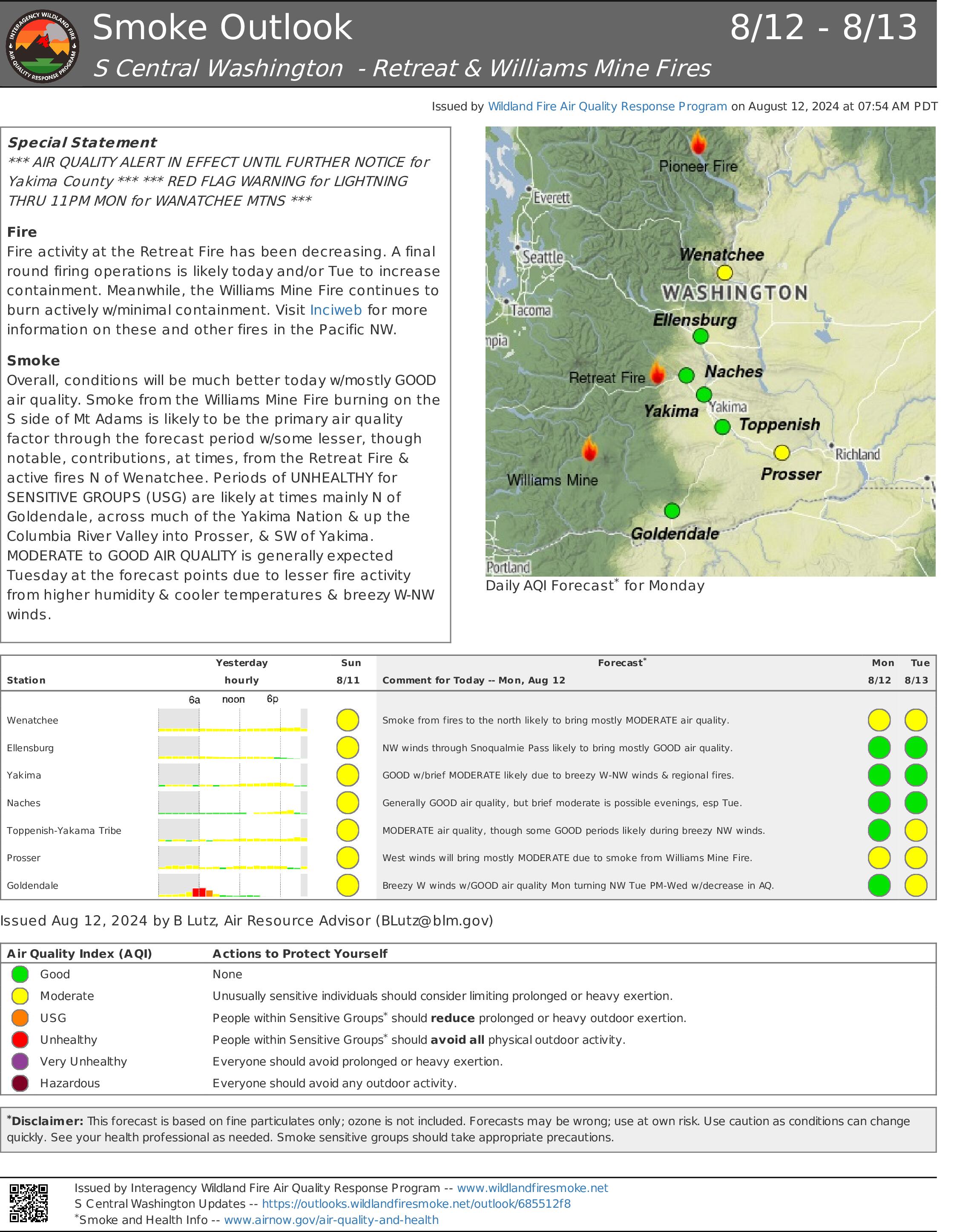
Air Quality and Smoke: Air quality and smoke condition outlooks can be found at airnow.gov.
Middle Fork Complex Bulldog Anderson Nellie Daily Update 08 12 2024
Related Incident:
Publication Type: News
Incident Commander: Rick Connell, Northern Rockies Team 5
Middle Fork Complex Location: 9 miles east of Garden Valley, ID
Bulltrout Location: 15 miles WNW OF Stanley, ID Wapiti Location: 2 miles southwest of Grandjean, ID
Start Dates: 07/24/24 – 08/06/2024
Cause: Lightning
Size:
Bulltrout: 271 acres Wapiti: 2452 acres
Middle Fork Complex: Bulldog: 1771 acres Anderson: 1594 acres Nellie: 1104 acres
Containment: Middle Fork Complex: 1% Bulltrout: 75% Wapiti: 0%
Resources on site:
Middle Fork Complex: 1 hotshot crew; 5 type 2 hand crew; 9 engines; 3 bulldozers; 3 water tenders
Wapiti: 1 type 2 hand crew; 3 engines
Bulltrout: 1 engine
Total Personnel: Middle Fork Complex: 296 Bulltrout:18 Wapiti: 52
KEY MESSAGE:
Join us for a Middle Fork Complex, Bulltrout, and Wapiti Fire Community Meeting Tuesday, August 13, 2024, at 7pm for an in-person explanation of current fire activity and planned actions on these fires. The Community Meeting will be located at the Lowman Emergency Services Station 80, at 8000 HWY 21, Lowman, ID.
CURRENT STATUS/PLANNED ACTIONS:
Middle Fork Complex: The Middle Fork Complex is comprised of Bulldog, Nellie, and Anderson fires. On the Bulldog Fire, firefighters continue to work along the Middlefork River Road thinning and trimming to remove flammable debris. Strategic overnight firing operations continue, and crews are securing the edges and holding the constructed control lines along the south side of the fire. Firefighters are working to protect private property and structures in the vicinity of Crouch.
The public is reminded that the Middle Fork Road is closed at the Forest Service boundary just south of Lightning Creek for firefighter and public safety. The Nellie and Anderson fires are burning in remote, rugged terrain. Yesterday activity on the fires increased due to changes in weather and crews continue to access opportunities to access the fire and lookout on Anderson. Crews plan to utilize a helicopter to conduct strategic firing operations today ahead of the fire in order to reduce fuels availability.
Wapiti Fire: Yesterday fire activity increased due to changes in weather and smoke was visible from State Highway 21 please use caution while driving in the area. Firefighters continue to ensure the structures in the vicinity of the fire are protected with improved defensible space, water pumps, and sprinklers. Firefighters are assessing the fire for opportunities to conduct strategic firing operations when conditions are favorable.
Bulltrout Fire: Crews will continue patrolling the fire area, repairing areas affected by suppression efforts, and extinguishing pockets of heat in the interior of the fire on the south side of the fire.
WEATHER AND FIRE BEHAVIOR:
Sunday a warm and dry air mass remained over the fire. As the inversion lifted, the temperatures increased, and relative humidity lowered. Today similar weather conditions are expected, with south/southwest terrain driven winds 5 mph and gusts between 10-12 mph. Fire activity will continue burning in timber and understory with group torching and become more active when the sky clears and inversions lift, specifically on ridgetops and areas exposed to winds.
CLOSURES, RESTRICTIONS, AND EVACUATIONS:
Middle Fork Complex: The Boise County Sheriff's Office continues to maintain the Level 2 evacuation notice for residents on and near the Middlefork Road between Stump Ranch Road up to Tie Creek Campground. The Boise National Forest issued areas closure for the fire area on August 8th (Closure #0402-06-58 and Closure # 0402-06-57).
Wapiti Fire: The evacuation order for Summer Homes and the Sawtooth Lodge remain in effect for the Wapiti Fire, as does the area closure issued by the Sawtooth and Boise National Forests (Closure #0402-05-92 effective July 27, 2024). This Order is for public and firefighter safety during fire suppression efforts of the Wapiti Fire.
Bulltrout Fire: The Bull Trout Fire Area Closure (0402-05-91) remains in effect for the roads, trails, and area surrounding the Bull Trout Fire. Boise National Forest issued this Order on July 27, 2024. It will be rescinded as soon as it is safe to do so.
Closure information and maps are posted on the Forests’ website and the fire’s Inciweb page as they are in place. https://tinyurl.com/2u8v3pf7
The Boise National Forest, Idaho Department of Lands, and Bureau of Land Management are in Stage 1 fire restrictions on state, endowment, private and federal lands within the West Central Mountains Fire Restrictions Zone. For more information on the restrictions and a map visit:
https://www.idl.idaho.gov/fire-management/fire-restrictions-finder/
Final Daily Ops Video for the Courtrock and Lone Rock Fires Available Now 08 12 2024
Related Incident: Courtrock FireLone Rock Fire
Publication Type: Announcement
Lone Rock and Courtrock fires Deputy Incident Commander, Todd Abel, with the Southwest Area Complex Incident Management Team 2, provides a special message for today's, Monday, August 12th, operational update. To watch the video, go to the Lone Rock Fire or Courtrock Fire Facebook pages (see below for links).
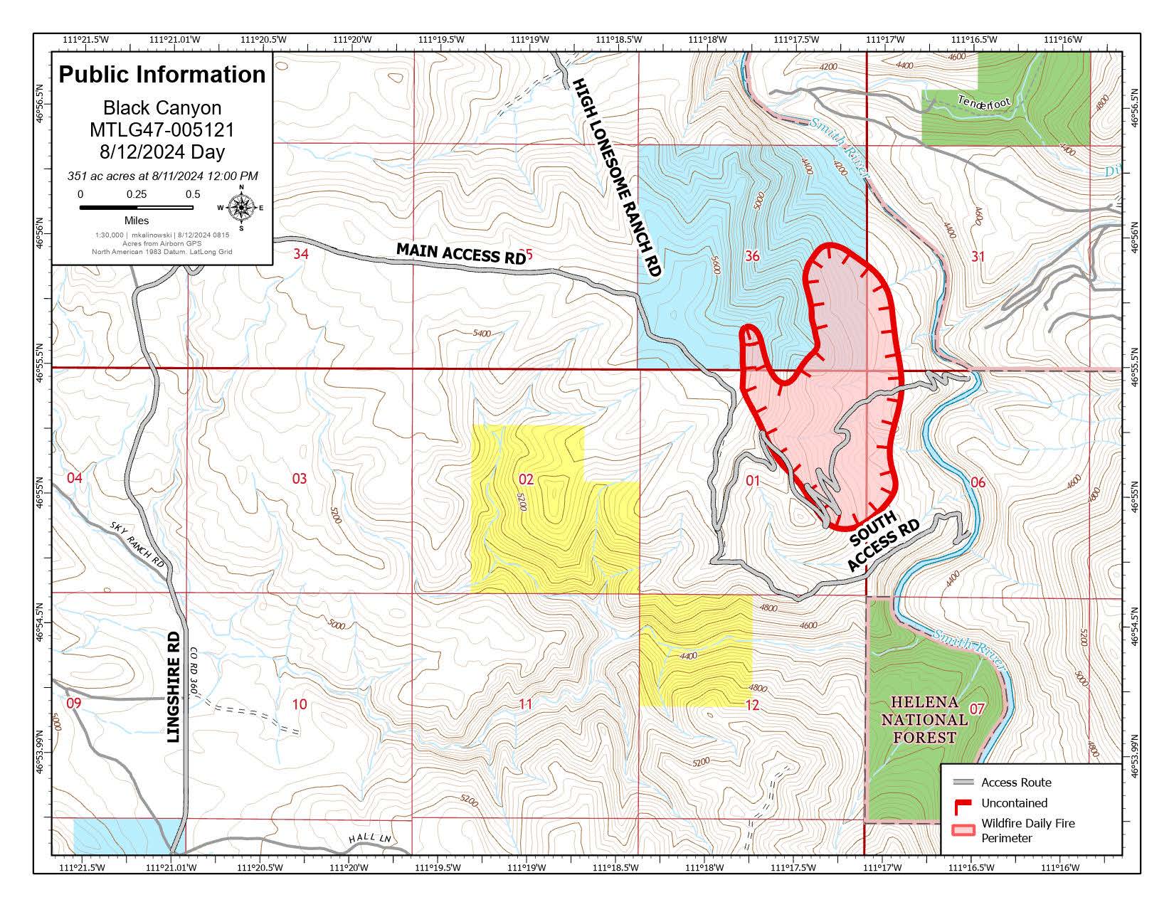
Black Canyon Fire Daily Update 08 12 2024
Related Incident:
Publication Type: News
Key Message
The DNRC County Assist Team assumed command of the fire on Sunday, August 11. Fire managers are using a full suppression strategy to manage the fire. The primary objectives are to keep the fire west of the Smith River, prep and protect structures and stop the fire’s spread by building direct and indirect containment lines.
Current Status
The Black Canyon Fire was discovered August 10, 2024, is burning in dense forest in private and state lands. The fire area received .75 inches of rain on Saturday evening, helping to slow fire activity. However, the northern edge of the fire has been the most active, due to receiving less precipitation, resulting in torching and spotting. Yesterday, fire manager assessed the fire on the ground and from a helicopter reconnaissance flight. Five helicopters provided air support by dropping water on the fire’s edge to slow its spread, allowing for fire crews to safely engage and create direct handlines. Today, helicopters will continue water drops on the northern end. Hand crews and heavy equipment operators will work on fire line construction on Black Canyon Lane.
Weather and Fire Behavior
Today, it will be mostly sunny with temperatures in the low 80s and variable southeast winds up to 5 mph shifting to the northwest in the evening. Expect isolated thunderstorms to move through the area bringing strong winds, light precipitation, and possible lightning in the next 24 hours.
Closures and Special Messages
A temporary flight restriction is in effect within 7 miles of the fire area. Be mindful of heavy traffic including fire personnel and equipment in the area.
Cougar Creek Fire Update 08 12 2024
Related Incident: Cougar Creek Fire
Publication Type: News
Cougar Creek Fire Update for August 12, 2024
Incident Commander Jeff Dimke
Complex Incident Management Team Northwest 12
509-210-2928, staffed 8 a.m. to 6 p.m.
Quick Facts:
Size: 23,614 Acres Start Date: July 15, 2024 Cause: Under investigation
Location: SW of Clarkston, 1 mile west of Hwy 129 and Grand Ronde River intersection
Containment: 50% Personnel: 373 Fire Strategy: Full suppression
Resources Assigned: 5 crews, 3 helicopters, 30 engines, 12 water tenders, 8 heavy equipment
The Cougar Creek Fire is burning within a mountainous and remote area on the Umatilla National Forest bordering the Wenaha-Tucannon Wilderness.
Operations: On Sunday, firefighters continued firing operations to increase depth on containment lines on the northwestern fire perimeter. A helicopter-mounted PSD (plastic sphere dispenser) dropped 5000 combustible “fireballs” to initiate firing operations on interior areas of the fire. On the south end of the fire, firefighters worked to remove structure wrap and collected and removed equipment no longer needed. Fire crews continued to secure and hold fire control lines in areas of recent burnout operations. A masticator and grader continued work on FSR 4039 to reduce woody debris and repair damage from heavy equipment.
Today, firefighters will assess the interior islands burned out yesterday. Crews will continue to monitor the fire perimeter and mop up hotspots near containment lines. The masticator and grader will continue repair work and activity fuels reduction on FSR 4039. Firefighters will backhaul excess equipment and remove hose from the line where it is no longer necessary. A group of senior firefighters from Australia and New Zealand recently arrived in the U.S. to assist with wildfire management, and we are grateful to have a few of them join us here to assist with the Cougar Creek Fire.
Evacuations and Closures: All level 1, 2 and 3 evacuations for the Cougar Creek Fire were removed this morning. The Grand Ronde Road will be reopened soon. Forest closure descriptions and maps are available online on the Umatilla National Forest closure website. In Washington, evacuation notices are posted on the Asotin County Sheriff website and Asotin County Emergency Management Facebook website. The TFR remains in effect: https://bit.ly/4duptei. Drone activity is prohibited under the TFR as firefighting aircraft cannot fly with unauthorized drones present. Please respect road and area closure orders and use extra caution while driving for your safety as well as our firefighters.
Weather and Smoke: The next in a series of weather disturbances will move through the region today. This wave is stronger and packing more moisture, increasing the chances for showers and thunderstorms this afternoon and tomorrow morning. The incoming storm is forecasted to result in much cooler temperatures and widespread measurable rain. Air quality in the region remains at Moderate quality. Learn more about smoke at http://wasmoke.blogspot.com/.
Homestead Complex Fire Update08 12 2024
Related Incident:
Publication Type: News
HOMESTEAD COMPLEX FIRE UPDATE
Fire Information Monday, August 12, 2024
Phone: 541-208-7100 (8 a.m. to 8 p.m.)
Email: 2024.homesteadcomplex@firenet.gov
Facebook: www.facebook.com/HomesteadComplexFireInfo
A morning operational briefing video is posted for today, August 12, on Facebook.
Inciweb: http://inciweb.wildfire.gov/incident-information/orupf-homestead-complex
Smoke Outlook: https://outlooks.airfire.org/outlook/d393fd74
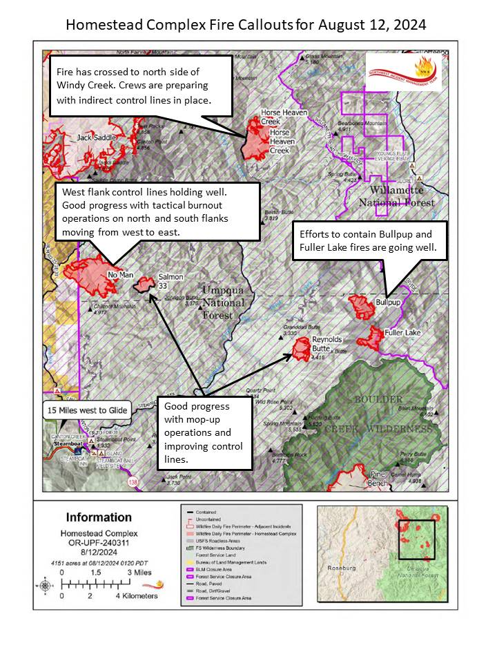
The Homestead Complex includes seven fires totaling 4,151 acres with an overall containment of 14%. There are 577 personnel currently working on the fire. Fire managers continue directing resources to fires based on threats to property, infrastructure, industry, and areas with the highest probability of success while providing for firefighter and public safety. The fire is being managed by Northwest Incident Management Team 8.
Yesterday, on the No Man Fire (1,612 acres), firefighters slowed growth toward dozer line in the southeastern corner of the fire with helicopter bucket drops. A hotshot crew scouted and began the prep work needed for tactical firing operations. The Salmon 33 (243 ac.) Fire saw negligible activity, staying within its footprint as crews focused on strengthening line and tying in a hot spot on the northern side of the fire. On Horse Heaven Creek Fire (1,201 ac.), crews continued plumbing hoselays and handline improvements. Prep on the 5851 and 010 roads progressed as well, and dozer line protecting the ridge is now halfway complete. On both Fuller Lake (318 ac.) and Bullpup (408 ac.) fires, clear air contributed to some fire activity before the smoke cap settled back in. The 5851 Road continues to hold on the east side of Fuller Lake despite the fire continuing to move in downhill in that area. On Bullpup, scouting operations were completed and the 300 Road is holding despite fire growth toward that control line. The Reynolds Butte Fire (335 ac) saw minimal activity. Crews utilized direct attack tactics on the southern end of the fire to neutralize some minor hot spots.
Today on the No Man Fire, crews will be capitalizing on recent successes by using a drone equipped for firing operations to deepen the now-completed control line on the northwestern side of the fire. Now firefighters can begin patrol and mop-up on those control lines to the east along the 3821 Road. On the southern side, containment should increase due to completed dozer line, and crews continue to plum in hoselay and prepare for tactical burnouts. Increased visibility could allow for the use of aircraft on No Man today. The Salmon 33 Fire continues to show minimal growth. Fire personnel will continue monitoring for changes in fire behavior, mopping up and increasing containment on that fire. On the Horse Heaven Creek Fire, an infrared flight in the early hours of this morning revealed that the fire has crossed Windy Creek to the north in some really rough terrain. Crews will be focused on putting in line to the north and east, potentially utilizing burnout operations originally scheduled for Tuesday. Resources will be prioritized today to reach that goal early. Contingency line operations are ongoing off the 5850 Road and the 010 spur down the ridgeline to the southeast. The Bullpup and Fuller fires remain staffed as firefighters work to complete containment line. Both fires are still within the 5851 and 300 roads. Engines are patrolling those roads and mopping up as the fire flanks in both directions. The Reynolds Butte Fire is getting close to patrol status. Once crews have completed mop-up operations, those resources will be reallocated around the complex. The Lost Bucket Fire (34 ac.) was contained on July 29 and remains in a patrol status.
Today’s weather: A marine layer moved over the majority of the complex last night, boosting relative humidity recovery to 90-100 percent. That layer should have dissipated by late morning but looks to return tonight. Relative humidity should be in the 40-50 percent range. The big change for today will be the cooler temperatures – 8 to 10 degrees cooler than what firefighters have been experiencing. Terrain-driven winds during the morning and noon hours will pick up at the higher elevations into the afternoon, with west-northwesterly gusts up to 20 mph possible.
Current forest fire restrictions and danger ratings are:
Fire Danger Rating: Very High
Industrial Fire Precaution Levels (IFPL): 3
Public Use Fire Restrictions (PUR): 3
CLOSURES:
The Bureau of Land Management (BLM), Roseburg District, has issued a closure order for portions of BLM land which border the Umpqua National Forest Emergency Fire Closure north of Steamboat. The closure order can be viewed here: https://www.blm.gov/sites/default/files/docs/2024-07/orwa-fpo-rbg-072624.pdf.
The Umpqua National Forest has Emergency Fire Closures in place. ORDER NO. 06-15-24-05 and ORDER NO. 06-15-02-24-01 can be found here: https://www.fs.usda.gov/alerts/umpqua/alerts-notices.
Fire Prevention:
Fuels remain dry and accidental fire starts can very easily happen. 9 out of 10 wildfires nationally are started by a human. Remain vigilant and be sure to do your part, it only takes one spark! #onlyyoucanpreventwildfires
Falls and Telephone Fires Update for Aug 12 2024 08 12 2024
Related Incident: Falls FireTelephone Fire
Publication Type: News
Falls and Telephone Fires Update for August 12, 2024
Telephone Fire Quick Facts:
Size: 53,989 Start Date: July 22, 2024 Location: 12 miles NE of Burns, OR
Containment: 64% Cause: Lightning/Natural
Falls Fire Quick Facts:
Size: 150,941 Start Date: July 10, 2024 Location: 13 Miles NW of Burns, OR
Containment: 87% Cause: Human-caused, under investigation
Structures Triaged: Residences: 386 / Commercial: 119 / Outbuildings: 760
Sand Mountain Fire Quick Facts:
Size: 7,582 Start Date: July 25, 2024 Location: 17 miles SW of Seneca, OR
Containment: 85% Cause: Lightning/Natural
Total Personnel Across all fires: 1135
Total Resources Assigned: 30 hand crews, 48 engines, 14 bulldozers, 31 water tenders, 1 masticator, 12 skidgines
Aerial resources assigned: One Type 1 helicopter
Priorities for Monday August 12
- 1) Initial Attack (IA) is the highest priority to keep all new fires as small as possible.
- 2) West side of the Telephone Fire/King Mountain area.
- 3) Northeast portion of the Falls Fire near Myrtle Creek.
Telephone Fire: Yesterday, firefighters continued to focus on the northwest corner of the fire, deepening the containment in the Gobbler’s Knob area and patrolled the eastern perimeter. Smoke from unburned fuel in a green pocket near East Cow Creek was visible from the roadway but did not impact containment. Today, firefighters will continue securing the fire edge along the 2820 Road east of Coffeepot Creek and working aggressively to keep fire west of the 28 Road. Additionally, ranchers, firefighters and cooperators will be working together to drive cows south along the 28 Road to safer, unburned areas for grazing. Other portions of the fire will continue to be monitored and patrolled.
Falls/Sand Mountain Fires: Yesterday, firefighters monitored and patrolled the south and west portions of the fire near Sand Mountain and Gilbert Ridge. Efforts were focused on preventing the fire from
impacting private property, rangelands, and livestock. Today, crews will continue to contain fire near the 31 Road northeast of Crane Flats. Removal of hazardous trees called snags in the northeast portion of the fire continues. Snags are dead, standing trees in the fire area without leaves or needles in the crowns. These trees are a significant hazard to wildland firefighters because they have lower fuel moistures. These trees burn more readily and topple easily in high winds. With the expected windy conditions later today, removing them is an important task. Crews will also be strengthening containment and monitoring earlier fire spread near Myrtle Creek. As containment increases and more of the fire is under patrol status, conditions remain challenging. Crews are staying vigilant, working to strengthen lines and secure problem areas.
Weather: Overnight, some portions of the fire area saw good relative humidity recoveries. Today’s elevated risk of thunderstorms could lead to increased weather instability. The atmosphere may be unsettled with rapid changes, and storms may bring lightning and gusty outflow winds up to 45mph. In the evening hours chances of thunderstorms could rise to 30%. Some portions of the area might see wetting rains. Looking ahead, temperatures are expected to trend cooler throughout the week.
Evacuations: There are no changes to the evacuation orders for Grant and Harney Counties. For the most accurate evacuation information, visit the Harney County Sheriff’s evacuation map: https://bit.ly/FallsFireEvac, or the Grant County Emergency Management Facebook page: https://www.facebook.com/profile.php?id=100068819321423
Closures: A closure is in effect for portions of the Malheur National Forest west of 395B, north of Mt. Vernon and south of Long Creek, in the Fox Valley area, including all roads, trails, and camping. A closure map is available on the Malheur National Forest website (https://www.fs.usda.gov/detail/malheur/news-events/?cid=FSEPRD1198892) and in local U.S. Forest Service offices.
Investigation: The U.S. Forest Service is seeking the public’s assistance with any information pertinent to the start of the Falls Fire on the Malheur National Forest. Submit any relevant information to SM.FS.R6TipHotLine@usda.gov.
Temporary Flight Restriction (TFR): TFRs in the area have been changing; pilots should check the latest information on the Federal Aviation Administration TFR website prior to flying: https://tfr.faa.gov/tfr_map_ims/html/index.html
Facebook: https://www.facebook.com/p/Falls-Fire-2024-61562126623985/
Falls Fire InciWeb: https://inciweb.wildfire.gov/incident-information/ormaf-falls-fire
Telephone Fire InciWeb: https://inciweb.wildfire.gov/incident-information/ormaf-telephone-fire
Fire Information Line: 541-208-4370, staffed 8 a.m. to 8 p.m. Email: 2024.Falls@firenet.gov
Harney County Non-emergency Evacuation Questions: 541-589-5579
Air Quality Questions: 541-573-2271. Air quality information, searchable by zip code: https://fire.airnow.gov/
Smoke Outlooks: https://outlooks.airfire.org/outlook
Borel Fire Evacuation Update Evacuations Lifted for All Zones 08 11 2024
Related Incident: Borel Fire
Publication Type: Announcement
All Borel Fire evacuations have been lifted. Everyone in areas of active fires should “Know Your Zone.” Go to Genasys Protect (tinyurl.com/jcdv55f9) to identify the zone you reside in.
2024 Borel Fire Daily Incident Update 08 12 2024
Related Incident: Borel Fire
Publication Type: News
Borel Fire Incident Update Monday, August 12, 2024
Fire Information: 559-481-7849, 9 a.m. to 7 p.m. Media Line: 559-492-9967, 9 a.m. to 7 p.m. Email: 2024.borel@firenet.gov
Linktree: linktr.ee/2024sqflightning
A Local Assistance Center will be open again today, August 12, from 10:00 am until 7:00 pm and will continue daily through Tuesday, August 13, from 10:00 am until 7:00 pm.
Address: Lake Isabella Senior Center, 6401 Lake Isabella Blvd. Lake Isabella, CA 93240.
Borel Fire: Crews continue to make excellent progress with suppression repair across the fire. Residents and visitors will see smoke during the day and occasional flare ups at night well within the fire perimeter. Neither pose a risk to escaping containment lines. Firefighters are still on high alert for any new fires that start in the immediate area and are ready for a rapid response. Burned Area Emergency Response (BAER) teams will be coming in to determine the need for and to prescribe and implement emergency treatments to stabilize and prevent unacceptable degradation to natural and cultural resources.. We encourage residents re-entering the area to proceed with caution to avoid unseen hazards caused by the fire, and help maintain the safety of repair crews working in the area.
Trout and Long Fire: For continuing information, please visit: https://inciweb.wildfire.gov/incident-information/casqf-2024-sqf-lightning
Weather: Similar warm and dry conditions that are a few degrees cooler than the past weekend, with winds of 5-15 mph and gusts up to 25 mph.
Sequoia National Forest & BLM Closures & Restrictions: The Borel Fire Piute Mountains Area Closure begins at the northwest corner of Section 30, Township 27 South, Range 33 East, Mount Diablo Base and Meridian, then continues approximately 47 miles around the Sequoia National Forest Boundary to the starting point.. All orders, maps, and accompanying appendices can be found on the Forest’s website: tinyurl.com/2en2d36k. The Bureau of Land Management Bakersfield Field Office has temporarily closed Long Valley Campground, Chimney Creek Campground, and portions of the Pacific Crest Trail (PCT). View the emergency closure order here: tinyurl.com/ 4mprcb9b. The PCT is closed between Hwy 178 at Walker Pass (mile 653) and the South Fork of the Kern River bridge (mile 717.7).
Road Closures: All road closures associated with the Borel Fire have been lifted. Visit the Kern County Public Works Department website for the additional information on county road closures (tinyurl.com/z6crvp6t)
Evacuations: All Borel Fire evacuations have been lifted. Everyone in areas of active fires should “Know Your Zone.” Go to Genasys Protect (tinyurl.com/jcdv55f9) to identify the zone you reside in.
Willamette Complex North Daily Update 08 12 2024
Related Incident: Pyramid and Slate FiresOre FireNorth Willamette Complex
Publication Type: News
Special Note
There will be a community meeting for the Willamette Complex North tomorrow—Tuesday, August 13th at 6:00 p.m. The meeting will take place at the Sweet Home Fire Station located at 1099 Long Street, Sweet Home, OR.
CURRENT SITUATION
The public may see or smell smoke within the proximity of the Ore Fire, due to a combination of tactical firing operations and weaker west winds across the area.
Ore Fire
Blue River, 2,576 Acres, 20% Contained, 163 Total Personnel, Cause Under Investigation
Yesterday, crews and aircraft on the northwestern flank continued work near the Waterfall Creek drainage—creating a control line and conducting burnout operations to inhibit spread beyond the 1509 Road. Crews observed less fire behavior during overnight patrol. Today, crews on the northern flank will continue to evaluate opportunities for firing, conducting burnout operations where feasible. Crews and heavy equipment on the western and eastern flanks will continue to prepare indirect fire line, patrol the perimeter, secure threats to the line by removing trees, snags and other fuels, and suppress any flare-ups or hot spots.
Pyramid Fire
East of Middle Santiam Wilderness, 1,324 Acres, 64% Contained, 292 Total Personnel, Lightning Caused
The established fire perimeter continues to hold, with pockets of intense and scattered heat identified by infrared across the fire. Today, crews will continue holding and improving line, mopping up and extinguishing hot spots.
Weather & Fire Behavior
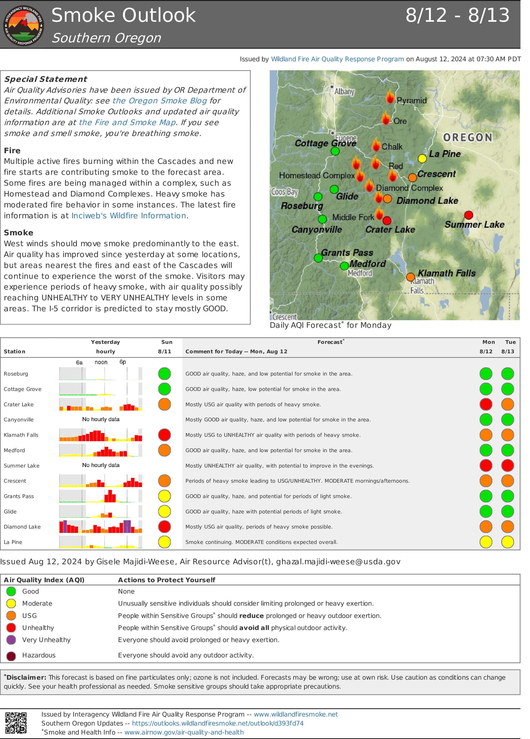
A large marine push will envelop the fire Monday and Tuesday, increasing humidity and decreasing temperatures, which may contribute to localized fog in the mornings. Predicted maximum temperature is 72 to 76 °F in the valleys and 66 to 70 °F on the ridgetops. Predicted minimum relative humidity is 50 to 56% in the valleys and 58 to 64% on the ridgetops. Even as weather moderates, heavy fuels continue to hold heat. Smoke and air quality conditions are available on: AirNow.gov
Evacuations, Closures & Fire Restrictions
On July 17th, the Linn County Sheriff’s Office, in coordination with the Willamette National Forest, issued a Level 3: Go Now Evacuation Alert for the closure area affected. Please refer to the Linn County Fire Map tinyurl.com/LinnCoFireMap for full details of the issued evacuation area (which will appear in red). To sign up for evacuation alerts, visit linnsheriff.org/.
Area, road, trail, and recreation site closures are in effect in the Willamette National Forest.
Specific information is posted at https://www.fs.usda.gov/alerts/willamette/alerts-notices/?aid=61574.
Fire restrictions are in effect for Willamette National Forest. Read the complete restrictions at: https://www.fs.usda.gov/alerts/willamette/alerts-notices/?aid=81487.
Wildfires are a no-fly zone for unauthorized aircraft, including drones. If you fly, we can’t.
For more information, visit http://knowbeforeyoufly.org.