
Limepoint and Cliff Mountain Fire Daily Update Monday 08 12 2024
Related Incident:
Publication Type: News
The Cliff Mountain Fire started by lightning on July 25 in Hells Canyon National Recreation Area. The fire is 1,108 acres with 20 percent containment. Although there has been no fire activity or smoke in the past several days, firefighters are continuing to actively assess current and future potential movement on the Cliff Mountain Fire and will take aggressive action if needed.
Evacuations: Cuprum is at Evacuation Level 2 (SET) per the Adams County Sheriff. Bear and Wildhorse are at a Level 1 (READY). Only residents and property owners are allowed in the area until further notice.
Closures: The Payette National Forest issued a closure to protect public safety. For more information, visit https://inciweb.wildfire.gov/incident-information/idpaf-limepoint-fire. County roads within the closure area are only accessible to firefighters and local residents. Huckleberry Campground is inaccessible due to county road restrictions and therefore closed. Forest Road 454 along the Snake River is open, but please drive cautiously.
Restrictions: Stage 1 Fire Restrictions are in effect for the Payette National Forest and all state, private and BLM lands in the fire area. Under these restrictions, campfires are allowed only in recreation sites within metal fire pits. Fires of any kind are not allowed in any dispersed camping areas.
Warner Peak Fire Daily Update 08 12 2024
Related Incident: Warner Peak Fire
Publication Type: News
Acres: 52,650 Start Date: 08/05/24
Location: Lake County, OR Personnel: 405
Containment: 4%
Highlights: Air and ground resources are being used to reinforce fire lines on both sides of the Warner Peak Fire. Warm, dry weather and particularly susceptible fuels promote fast fire spread. Steep and mountainous terrain in some parts of the Refuge makes access and travel extremely difficult for firefighters. Active fire behavior is predicted while the fuels are dry, and temperatures are elevated. Firefighters are working to minimize damage to wildlife habitats, natural resources, and cultural heritage sites within the affected area.
Fire Activity: Crews have continued to make significant progress securing the eastern area of the fire, constructing line utilizing natural and manmade features such as roads and rocky outcrops. Initial containment along the eastern side of the fire will enable firefighters to continue safely and effectively engaging along the southern and western fire edge. These operations will continue through the night shift when fire intensity is lower, removing fuels ahead of the wildfire to create more secure and defensible fire control lines.
Fire behavior will remain very active along the southwestern portion of the fire as it moves into receptive fuels, pushed by winds out of the west. Air resources have been engaged to support crews on the ground and will be used where appropriate as the weather permits. Crews will work to secure lines and cool hot spots near the line and be ready to extinguish any spot fires. A UAS (Unmanned Aircraft System) with IR sensors is being used to map the fire perimeter.
Mop up and patrol operations continue across the complex.
Closures: The Hart Mountain National Antelope Refuge is closed for public and firefighter safety. The Incident Management Team is working in coordination with local emergency management to evaluate any potential need for closures or evacuations in the fire area.
Weather: Temperatures remain in the mid-80s with humidities down to 14%. West to northwest winds will be brisk 15 mph with gusts of up to 25 mph. These conditions are expected to continue over the next several days.
Smoke: Wildfire smoke from the Warner Peak Fire may impact the community of Plush. Go to fire.airnow.gov/ to see the latest smoke conditions in your community.
More Information:
Information Phone Line: 541.208.1770
Email: 2024.warnerpeak@firenet.gov
Facebook: https://www.facebook.com/profile.php?id=61563957367189
Inciweb: https://inciweb.wildfire.gov/incident-information/orshr-warner-peak
Boulder Fire Daily Update August 12 2024 08 12 2024
Related Incident:
Publication Type: News
**Boulder Fire Daily Update - August 12, 2024**
In the northwest corner of the fire, light fire activity occurred in the Fawn Creek area, and night crews directed their efforts to secure and strengthen the containment line. The connection of a dozer line and road 421E was completed yesterday, which created a robust fire perimeter and will allow for continued firing operations when weather conditions are favorable. Aerial resources were utilized to conduct bucket drops to aid in fire suppression strategies. Night shift crews continue working on the Boulder Fire to help secure and anchor existing lines.
Limepoint and Cliff Mountain Fires Update Monday 08 12 2024
Related Incident: Limepoint Fire
Publication Type: News
Limepoint and Cliff Mountain Fires
Monday, August 12, 2024
Contact Fire Information: 208-992-3032
Limepoint: https://inciweb.wildfire.gov/incident-information/idpaf-limepoint-fire
Cliff Mountain: https://inciweb.wildfire.gov/incident-information/idpaf-cliff-mountain
https://www.facebook.com/payettenationalforest/
Despite continued hot and breezy conditions over the past several days, the Limepoint Fire perimeter has largely remained static. The fire is most active on the north and east sides where steep slopes combined with upslope winds and dry vegetation have contributed to active fire conditions. If similar conditions continue this afternoon, the public may see an increase in smoke on the northeast side of the fire.
Firefighters on night shift are working in the areas of Bear and Cuprum ensuring that there are no hot spots that could threaten the existing fireline. Securing the communities of Bear and Cuprum has been a concerted effort and continuing priority for fire management. In the next several days, firefighters will begin rehabilitation of some dozer lines and other suppression methods, increasing activity in the area.
Crews are making steady progress tying in handline and dozer line to natural barriers along the east side of the fire. Out of an abundance of caution to protect surrounding communities, crews are using heavy machinery, such as masticators and bulldozers, to create a contingency line on the east side of the fire.
While the health and safety of firefighters and the public is always the number one priority, the protection of critical infrastructure, including powerlines on the south side of the fire, is a paramount concern and focus of protection efforts.
The Cliff Mountain Fire started by lightning on July 25 in Hells Canyon National Recreation Area. The fire is 1,108 acres with 20 percent containment. Although there has been no fire activity or smoke in the past several days, firefighters are continuing to actively assess current and future potential movement on the Cliff Mountain Fire and will take aggressive action if needed.
Evacuations: Cuprum is at Evacuation Level 2 (SET) per the Adams County Sheriff. Bear and Wildhorse are at a Level 1 (READY). Only residents and property owners are allowed in the area until further notice.
Closures: The Payette National Forest issued a closure to protect public safety. For more information, visit https://inciweb.wildfire.gov/incident-information/idpaf-limepoint-fire. County roads within the closure area are only accessible to firefighters and local residents. Huckleberry Campground is inaccessible due to county road restrictions and therefore closed. Forest Road 454 along the Snake River is open, but please drive cautiously.
Restrictions: Stage 1 Fire Restrictions are in effect for the Payette National Forest and all state, private and BLM lands in the fire area. Under these restrictions, campfires are allowed only in recreation sites within metal fire pits. Fires of any kind are not allowed in any dispersed camping areas.
Wolf Creek Fire Daily Update August 12 2024 08 12 2024
Related Incident: Wolf Creek Fire
Publication Type: News
**Wolf Creek Fire Daily Update - August 12, 2024**
Sunday was the second day no new spots were detected, and fire activity was low across the Wolf Creek Fire yesterday. The fire perimeter increased on the northern and southern ends, and containment increased to 52%. Crews are working diligently in mopping up along the containment line. Mop up operations involve extinguishing or removing burning material to ensure the fire has been snuffed out and won’t reignite.
Daily Update on Clearwater Fire for Monday 08 12 2024
Related Incident:
Publication Type: News
Fire Location: 11 miles west of Wapiti, WY
Size: 1,896 acres
Containment: 43%
Personnel: 80
Start Date: 7/19/24
Cause: Lightning
Incident Commander (IC): Ron Steffens, Wyoming Type 3 Team
Operations
Firefighters continued cutting hazardous trees in the Elk Fork Campground yesterday — see related article here — and did some additional work in the Elk Fork drainage. Today, similar work will continue there while engines patrol the highway corridor, monitoring fire behavior and watching for any activity that could threaten the roadway. The fire’s southern perimeter may also be monitored by aerial resources.
With the fire less active in the interior and not posing an immediate threat to perimeter lines, some crews have been reassigned to other incidents with more active fire requiring direct suppression. This leaves an appropriate number of resources here for this fire and is a standard practice with the national fire workforce when numerous regions throughout the country are experiencing a high volume of fire activity. Currently,79 large active wildfires are being managed with full suppression strategies nationwide, and approximately 27,000 firefighters and support personnel are assigned to incidents. Click here to view an overview map of fire activity.
Due to heavy fuels in steep, inaccessible terrain, the Clearwater fire is likely to burn and smolder for some time in conifer forest, brush, and dead and down logs, even with cooler temperatures and precipitation.
Closures
Elk Fork Campground is closed indefinitely; Wapiti Campground and Clearwater Campground are closed until fire conditions allow otherwise. A road and trail closure are in effect at NFS Road #424, Elk Fork Road and NFS Trail # 760, Elk Fork Trail. Click here to view the closure order (#021404-24-03). For safety reasons, the public is asked to respect closed campgrounds and trails. A temporary flight restriction (TFR) is in effect until August 19, 2024.
Weather | Anticipated Fire Behavior
The forecast calls for moderated weather over the next few days, though gusty winds with thunderstorm outflows may allow for some growth along the perimeter.
Safety Information
The Shoshone National Forest implemented Stage 1 fire restrictions due to very dry conditions of fuels and continued hot, dry weather. Click here to view a copy of Stage 1 Fire Restrictions order (#02-14-04-24-04).
Photo
Click on the caption below for image. Note: due to the size of the file, the picture may take a few seconds to load.
WEST MOUNTAIN COMPLEX Boulder Snag and Dollar Fires Update 08 12 2024
Related Incident: Dollar Fire Boulder Fire
Publication Type: News
Boulder Fire
9 miles SW of Cascade
1,795 acres
Containment: 6%
Personnel: 425
Start Date: 7/24/2024
Snag Fire
11 miles E of Cascade
13,050 acres
Containment: 0%
Personnel: 21
Start Date: 8/5/2024
Dollar Fire
18 miles NE of Cascade
1,377 acres
Containment: 0%
Personnel: 0
Start Date: 8/5/2024
Incident Commander
Tony DeMasters, Great Basin Complex Incident Management Team #2
---
Weather | Anticipated Fire Behavior:
A fire weather watch for lightning is in place for this evening through Tuesday, which is issued by the National Weather Service when the combination of dry fuels and weather conditions support extreme fire danger. Gusty winds and evening thunderstorms are predicted, but little rain is expected to accompany the storms.
Boulder Fire: https://inciweb.wildfire.gov/incident-information/idbof-boulder-fire
In the northwest corner of the fire, light fire activity occurred in the Fawn Creek area, and night crews directed their efforts to secure and strengthen the containment line. The connection of a dozer line and road 421E was completed yesterday, which created a robust fire perimeter and will allow for continued firing operations when weather conditions are favorable. Aerial resources were utilized to conduct bucket drops to aid in fire suppression strategies. Night shift crews continue working on the Boulder Fire to help secure and anchor existing lines.
Snag Fire: https://inciweb.wildfire.gov/incident-information/idbof-snag-fire
The Snag Fire remained active yesterday and is now within a ½ mile of the Warm Lake Highway. Due to this progression, an engine was placed on the highway throughout the night to continue monitoring the fire’s growth. The fireline near the Warm Lake Highway will be continuously evaluated every hour. Firefighters are prepared to take action if the fire breaches the highway. Crews are creating a dozer line to the southwest and connecting it to an indirect line to solidify a fire perimeter for protection of the Horsethief Reservoir area. In remote and tough terrain such as this, direct firefighting is challenging. Confining the fire to a specific area allows firefighters to focus their resources more effectively. By utilizing a confinement strategy, firefighters are able to put control line in more favorable locations, allowing for a higher probability of success. It also prioritizes firefighter safety, as they can use existing barriers and indirect line. Water pumps and hoses are staged at structures around the Snag Fire and are ready to be activated if needed.
Dollar Fire: https://inciweb.wildfire.gov/incident-information/idbof-dollar-fire
The southwest corner of the Dollar Fire saw the most activity yesterday. Crews continue to monitor the Dollar Trailhead and a nearby drainage to evaluate if the fire is moving into terrain that is more conducive to fire spread. The top end of the fire ran into a previous burned area (formerly the Cascade Complex) which led to decreased fire activity because the fire did not have any fuels to continue its progress.
SNAG FIRE EVACUATION INFORMATION
The Valley County Sheriff’s Office issued a “ready” evacuation order for Warm Lake residents and the North Shore Lodge at Warm Lake on August 7th. The map can be found on Inciweb: https://tinyurl.com/42auxnk8. A second “ready” evacuation order was issued on August 8th for the Horsethief area, including the YMCA Camp, and areas of Scott Valley. This map can also be found on Inciweb, with the relevant areas outlined in purple: https://tinyurl.com/4vfj657x
Ingress along the Warm Lake Highway on the east side of Scott Valley is closed. Currently, westbound traffic toward Cascade along the Warm Lake Highway is allowed. Residents and recreators in the area will be notified of the closure. Residents not currently at their homes will be granted one-time access into the Warm Lake area to retrieve animals and other property if they can provide a valid address. Anyone who remains in the area should be prepared for a full closure of the Warm Lake Highway and have enough fuel to exit the area via the Deadwood area or Lick Creek Road. As a reminder, the South Fork Road remains closed due to construction unrelated to the Snag Fire.
Review the READY, SET, GO evacuation procedure for Valley County: https://www.co.valley.id.us/ReadySetGo
For timely information on evacuations, check out your county’s emergency alert system.
- Valley County: https://www.co.valley.id.us/CompleteEmergencyNotificationandAlerting
- Adams County: https://public.alertsense.com/SignUp/PublicUser.aspx?regionid=1077
FOREST CLOSURES
Wolf Creek Fire Closures: On the Payette National Forest, a closure including popular National Forest System roads around the Wolf Creek fire such as: sections of NFS #1763 (West Mountain Jeep Trail), #835, #206, #326. On the Boise National Forest, Forest Road #435 (Anderson Lake Road) was closed on August 1.
Boulder Fire Closures: The Boise National Forest has issued a closure order #0402-04-98 for National Forest System (NFS) roads, trails and lands encompassing the Boulder Fire. The closure was enacted to protect public safety and support fire suppression activities. The closure includes Blue Lake and Snowbank Mountain Road (#446) along with all #404 and #421 system roads.
Snag Fire Closures: The Boise National Forest has issued closure order # 0402-04-100 for the National Forest System (NFS) roads, trails, and lands around the Snag Fire.
For maps and more detailed descriptions of the closures on the Payette National Forest, please visit: https://www.fs.usda.gov/alerts/payette/alerts-notices
For maps and more detailed descriptions of the closures on the Boise National Forest, please visit: https://www.fs.usda.gov/alerts/boise/alerts-notices
Fire Restrictions: Stage 1 Fire Restrictions have been issued for the Payette Fire Restrictions Area on the Payette National Forest and the West Central Mountains Fire Restrictions Area on the Boise National Forest. For more information on the restrictions and a very helpful interactive map, visit https://www.idl.idaho.gov/fire-management/fire-restrictions-finder/
Important Links
- Payette National Forest: https://www.fs.usda.gov/payette
- Payette National Forest Facebook: https://www.facebook.com/PayetteNationalForest
- Boise National Forest: https://www.fs.usda.gov/boise
- Boise National Forest Facebook: https://www.facebook.com/BoiseNationalForest
- Idaho Department of Lands: https://www.idl.idaho.gov/fire-management/
Sunday Evening Update for the Park Fire 08 11 2024
Related Incident: Park Fire
Publication Type: News
Park Fire Incident Update, Evening of Sunday, August 11, 2024
For more information on the Park Fire, please visit: https://inciweb.wildfire.gov/incident-information/calnf-park-fire
Size: 429,188 acres with 38% containment | Personnel: 5,805
Lassen National Forest:
Today on the #ParkFire, firefighters held the fire south and east of Turner Mountain through use of aircraft, direct line construction and mop-up. Mop-up is a phase of fire suppression that involves removing or extinguishing all burning or smoldering material along containment lines.
Overnight, direct attack to extinguish active fire and smoldering areas the fire's perimeter. Night-capable aircraft are available to support ground resources.
Unified partners have converged firefighters to completely suppress the #ParkFire
The #ParkFire has burned 113,600 acres on the Lassen National Forest.
CAL FIRE:
The fire continued to consume interior islands, pockets of unburned fuels, and heavy dead and down materials in the timber understory. Short range spotting continued to challenge containment lines.
Better humidly recovery is expected tonight, which will aid fire suppression efforts. Monday, a cooling trend will bring more favorable temperatures, which may be accompanied by gusty winds.
For more information on the Park Fire please visit:
- CALFIRE Park Fire: https://www.fire.ca.gov/incidents/2024/7/24/park-fire
- CAL FIRE Shasta-Trinity Unit/Shasta County Fire Department: https://www.facebook.com/CALFIRESHU
- CAL FIRE Tehama-Glenn Unit/ Tehama County Fire Dept: https://www.facebook.com/CALFIRETGU
- Butte County, CA: https://www.facebook.com/ButteCounty
- Butte County Sheriff: https://www.facebook.com/bcsonews
- Plumas County Sheriff: https://www.facebook.com/plumascountysheriff
- Shasta County Sheriff: https://www.facebook.com/ShastaSheriff
- Tehama County Sheriff: https://www.facebook.com/profile.php?id=100088640404140
Williams Mine Fire Update 08 11 2024
Related Incident: Williams Mine Fire-GPNF
Publication Type: News
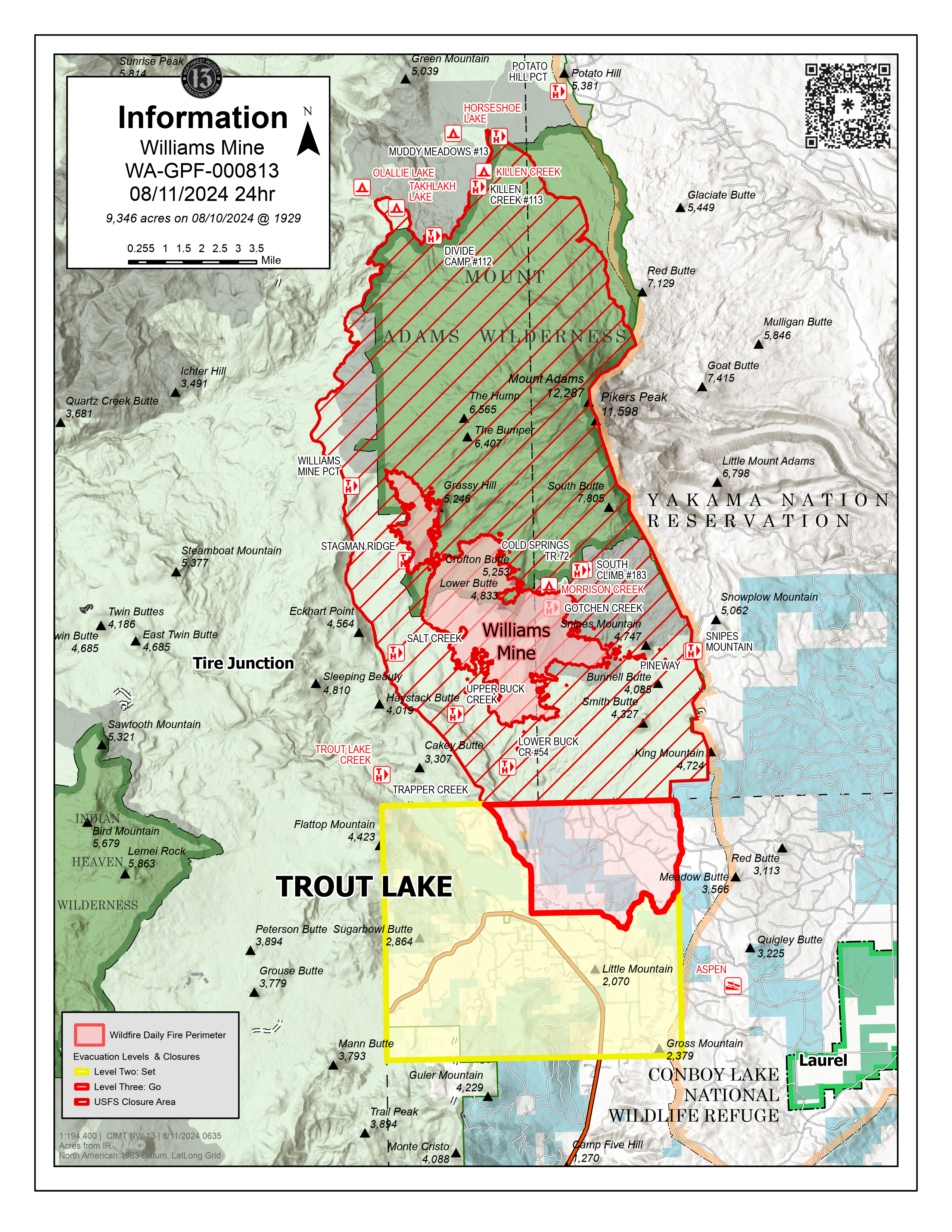
Williams Mine Fire Update for Sunday, August 11, 2024
KEY MESSAGES:
To protect the community while suppressing the Williams Mine Fire, NW-13 has established an incident command post in Trout Lake. Incident officials recognize the inconvenience and appreciate your patience as fire engines, crew-carriers and heavy machinery navigate to and from the fire perimeter through the community. NW-13 continues to work with local officials to prioritize protection efforts for the community of Trout Lake, which is south of the fire and the community of Glenwood, east of the fire.
Night operations were established last night to assess fire growth, prioritize operational engagement and enhance day shift firefighting efforts around the southern perimeter of the incident.
The fire perimeter experienced primarily eastern progression yesterday, and the main eastern flank of the fire is now approximately 2.5 miles away from the Yakama Nation tribal land boundary, near the Pineway Trailhead. Several small spot fires are further east, an estimated 1-2 miles away from the closest point of the Yakama Nation tribal land boundary, around the base of Snipes Mountain.
CURRENT STATUS:
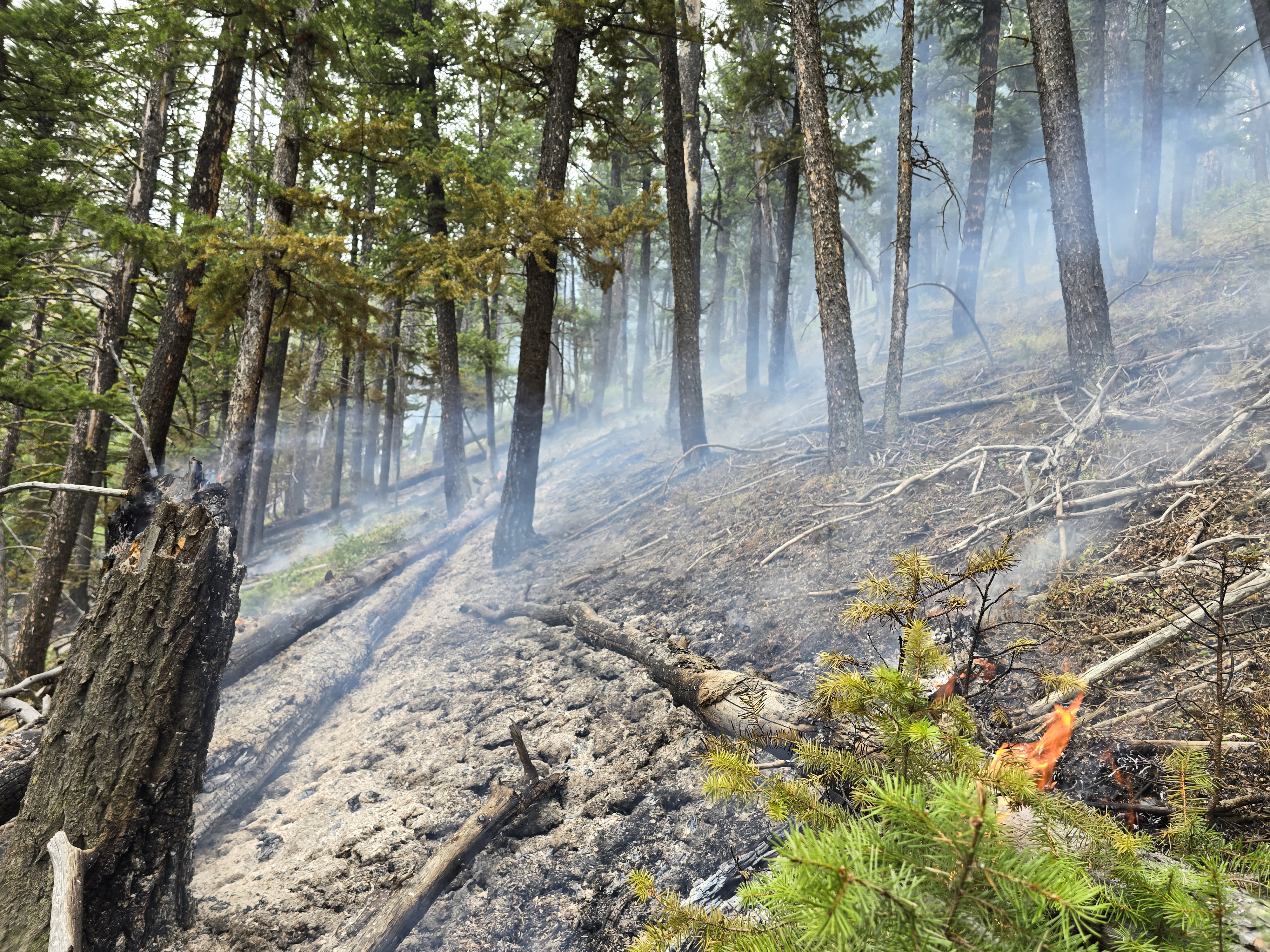
The Williams Mine Fire is currently burning primarily within the 2012 Cascade Creek fire scar, with dense brush and heavy dead/down vegetation. These fuels have led to rapid fire growth and are responsible for heavy smoke and the visible plumes over the fire area. Yesterday, due to intense winds, spot fires were established approximately one mile ahead of the main body of fire on the eastern flank. The fire is expected to move upslope towards Mt. Adams, through the previous burn scar.
Heavy equipment are establishing an anchor point where firefighters can safely construct fire line in order to generate potential containment opportunities and stop forward fire perimeter progression. Masticators are working on roadways to create fire breaks to support primary and contingency containment lines. Firefighters will continue to assess/validate indirect options to the east of the fire to minimize easterly progression, with the predominantly westerly wind pattern.
Two Type 1 helicopters were assigned to the fire yesterday. The Yakama Nation assisted with reconnaissance operations utilizing a Type 3 helicopter. This coordinated effort allows fire managers to develop situational awareness and identify potential control features. Scooper planes will continue to be utilized on the fire and are being filled in the Columbia River. They currently are operating between Memaloose Island and Lyle, Washington. Fire managers ask residents and visitors to be mindful as they recreate around waterways in proximity to the fire area as an aid in public safety.
CLOSURES:
Level 2 & 3 evacuations are in effect for the community of Trout Lake. An evacuation center is located at 1455 NW Bruin County Road, White Salmon, Washington. Evacuations are coordinated through the Klickitat County Sheriff’s Office and the Skamania County Sheriff’s Office. The FS-23 and FS-25 roads are closed, see the Williams Mine Area and Road Closure for more details. The Pacific Crest Trail (PCT) is closed from the PCT's intersection with FS 23 to Potato Hill. The closure spans the entire Mt. Adams Wilderness.