
East Fork Fire August 29 2023 Update
Related Incident: East Fork Fire
Publication Type: News
NORTHERN ROCKIES TEAM 6
INCIDENT COMMANDER: Paul Roose
East Fork Fire
Kootenai National Forest/Flathead National Forest
Fire Information 406-285-8634 Eastforkfireinfo@gmail.com
August 29, 2023
Location: 12 miles south of Trego, MT
Start Date: 7/30/2023
Cause: Lightning
Size: 5,112 acres
Containment: 15%
Total Personnel: 621
Engines: 15
Hand Crews: 12
Helicopters: 2
Yesterday’s Events: The success of burning operations was mixed on Monday. On the south side of the fire fuels were not receptive southeast of Advent Creek. However, to the north, above the 3710 road, burning was successful. On other areas of the fire, firefighters continued to establish direct line in rough country. Near the Advent Creek area, crews did reconnaissance to prepare for heavy equipment work tomorrow. All around the fire, teams worked with a sense of urgency to complete tasks in advance of the coming weather. Night Operations burned until 1 am and elsewhere crews spent the night monitoring the fire, stacking logs, and chipping brush.
Plans for Today: Burning operations should continue by the 3710 Road, and possibly on the south side, if conditions align to carry fire safely. As heavy machinery frees up, it will shift south to construct line with large machinery in the Advent Creek area. In the afternoon, crews will prepare for the change in weather which will bring significant wind gusts and thunderstorms as part of the advancing cold front. Safety is of the highest concern during these winds and everyone will be especially aware of the very real possibility of falling trees and egress issues.
Weather Update: This is the last day of hot, dry weather as a Pacific system moves in around 6pm bringing winds, thunderstorms, clouds, rain, and colder temperatures. This system is seen as another season-slowing event which will again leave good opportunities for firefighters after it passes.
Evacuations: Some communities remain in a Pre-Evacuation Warning. Residents may return to their homes under a Pre-Evacuation Warning, but may need to leave again on short notice. For more information, go to the Lincoln County and Flathead County Sheriff’s Department Facebook pages.
Public Meetings: No public meetings are scheduled at this time, though fire personnel are available to address questions or concerns via the email address and telephone number noted above.
See the daily operations update video here: https://youtu.be/SBjAeo_dyVk
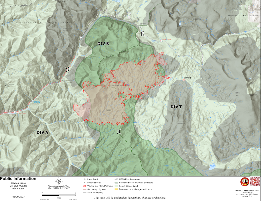
Bowles Creek Fire Update August 29
Related Incident: Bowles Creek Fire
Publication Type: News
The Nevada Team 3 Incident Management Team is managing the Bowles Creek Fire. The Bowles Creek Fire is currently at 6,988 acres. Fire crews will be present along Hwy 38, Skalkaho Road, as fire operations and fire rehabilitation work continue. Motorist are urged to be aware of falling branches and debris as thunderstorms and wind gusts of 35-50 mph gusts after 1400. A Temporary Flight Restriction (TFR) has been removed and aviation is permitted over the fire area.
CURRENT SITUATION & PLANNED ACTIONS
The fire completion has increased to 28%. Due to limited fire activity, fire personnel are beginning to focus on suppression rehabilitation to mitigate adverse resource effects resulting from fire suppression activities. Crews are focusing on rehabilitating Sand Basin Road with heavy equipment before upcoming inclement rain approaches. Protection of wilderness study areas and roadless characteristics, surface erosion control, weed suppression, maintenance of forest improvements, and developed and undeveloped recreation sites are planned for the remainder of this week. Sitework will encompass previously built handlines and other contingency lines, safety zones, drop points, fueling locations, spike camps, heliwells, and helispots (both related to helicopter operations).
Deep Fire Update August 29 2023
Related Incident: Deep Fire
Publication Type: News
CURRENT SITUATION
The Deep Fire is currently mapped at 3,924 acres and is 60% contained. As predicted, the shift in wind direction brought smoke from multiple fires to the south/southwest from late afternoon until dark yesterday. However, these winds had no effect on the Deep Fire activity or containment.
Yesterday afternoon the fire in the northeastern end of Deep Creek made a short run as it aligned with a small stringer of trees and burned to the top of the ridge. The high elevation bowl over that ridge is rocky and does not have enough vegetation to carry fire.
The fire does continue to back slowly into Little Salt Creek as well. Aircraft is being used to check the momentum of that spread while firefighters work to move north on the Stuart Fork Trail toward Morris Meadow, re-setting hose and pumps to eventually turn containment efforts east onto the Deer Creek Trail. If the fire should cross Little Salt Creek, containment could successfully occur there.
On the southeastern corner, line tying the edge of the fire into the rocky outcropping to the east has been completed, and firefighters are working to improve those lines and mop up any hotspots that could threaten containment today. The southern heel of the fire closest to the Van Matre inholdings and the Trinity Alps resort, has been cold for several days. Crews are working to pull hose and pumps out of those areas today, as well as to backhaul any unneeded hose and equipment from the fireline. Because fire behavior has diminished significantly, most evacuation orders were downgraded to warnings only. For the most recent evacuation information, visit: https://www.facebook.com/people/Trinity-County-Sheriffs-Office/100064589806351/
There is still scattered heat within the fire area, and residents and visitors are likely to continue to see isolated smokes from unburned islands of vegetation for the foreseeable future. For this reason, the area remains closed.
WEATHER
Northwest winds are again predicted today, with slightly higher humidity and slightly lower temperatures. Warm and dry conditions are expected to reestablish tomorrow.
FOREST CLOSURES
There is a forest closure associated with the Deep Fire. For current information on forest closures, visit https://www.fs.usda.gov/stnf
EVACUATION UPDATES
For the latest evacuation information from the Trinity County Sheriff’s Department: https://www.facebook.com/people/Trinity-County-Sheriffs-Office/100064589806351/
For information on evacuation resources from the Trinity County Office of Emergency Services: https://www.trinitycounty.org/OES
To sign up for codeRED notifications: text “TrinityCA” to 99411.
Tyee Ridge Complex Evening Update 082823
Related Incident: Tyee Ridge Complex
Publication Type: Announcement
Acreage: 2,896
Containment: 5%
Weather Helps Firefighters on Tyee Ridge Complex
Umpqua, OR – Crews continued to make progress on the Tyee Ridge Complex in western Douglas County. To the north, the Blue Pool and Yellow Point Fires are in mopup and will be in patrol status beginning tomorrow. Although the Big Tom Fire was active, hand and dozer line construction increased around the perimeter. Near Umpqua, the Lighthouse 3 Fire became more active in the afternoon. Helicopters and retardant drops assisted ground forces on both the Lighthouse and Tyee Mountain Fires. With Oregon State Fire Marshal structure preparation completed near the Lighthouse and Cougar Creek Fires, resources focused on holding and improving line, including around spot fires east of Hubbard Creek. Hubbard Creek Road was closed in the early afternoon while fallers and a skidder removed hazard trees near powerlines.
Resources today included 26 crews, 10 helicopters, 45 engines, 25 dozers, and 35 water tenders. At least 3 more crews, more dozers, and more water tenders are expected to arrive tomorrow. Four task forces will continue to provide structure preparation and point protection as needed. Efforts will focus on further line construction and mopup in accessible terrain, and on responding to the ongoing challenges of steep terrain, rolling material, and snags.
Cloudy conditions, temperatures in the 50s, and relative humidities of 90-95% will further aid the firefighting effort tonight. Under these conditions, flame lengths and spread rates are expected to continue to drop. However, there is still potential for uphill runs, torching, and spotting. Tomorrow, temperatures are forecast to be in the low 70s with winds 2 to 4 miles per hour from the NW.
All evacuation notices issued by the Douglas County Sheriff's Office remain unchanged. An estimated 183 persons have evacuated. The Red Cross shelter for evacuees is now located at The Way Church of Sutherlin located at 1352 E. Central Ave. in Sutherlin, OR. To shelter livestock, contact Douglas County Fairgrounds at 541-957-7010. Companion pets can be sheltered at Saving Grace Pet Adoption Center in Roseburg. To view the current evacuation information map, go to www.dcso.com/evacuations.
Evacuations: Level 3 (Go Now!) from the 11000 block of Hubbard Creek Rd. to Millwood Dr. Level 2 (Be Set) from Hubbard Creek Rd. from the Millwood Dr. intersection to Melqua Rd., all residences on Briarwood Rd., and all residences on Lighthouse Rd. Level 1 (Be Ready) for all residences on Tyee Rd from the 1800 block (Fanchin Ln.) to the 6700 block (BLM Rd. 25-7-15.0/Rock Creek Rd.).
Closures: Hubbard Creek Road at Millwood Drive. Please avoid this area.
Happy Camp Complex Incident Update August 28 2023 Evening
Related Incident: 2023 Happy Camp Complex Klamath NF
Publication Type: News
HAPPY CAMP COMMUNITY MEETING: A community meeting and fire operations update will be taking place Tuesday, August 29th at 5:30 p.m. at the Karuk Administration Gym located at 64236 Second Avenue, Happy Camp, CA 96039.
WEST SIDE OVERVIEW (ACRES/CONTAINMENT): Elliot (9,080 acres, 2%), Malone (544 acres, 7%), Ufish (1,856 acres, 0%)
Firefighters on the west side of the Happy Camp Complex focused their efforts on strengthening containment lines and continuing progress from last night’s firing operations near Titus Peak. On the Elliot Fire, crews continued to patrol and extinguish remaining hot spots along the Highway 96 corridor. If conditions allow, strategic firing operations will resume tonight for the Malone and Ufish fires. Smoke from fires to the west continue to impact air quality and visibility for aircraft operations during the day.
EAST SIDE OVERVIEW (ACRES/CONTAINMENT): Head (6,875 acres, 35%), Block (0.1 acres, 100%), Townsend (81 acres, 100%), Den (294 acres, 100%), Scott (1,881 acres, 70%), Lake (199, acres, 5%)
Fire crews made good progress on securing containment lines on the Head Fire today, further protecting the community of Hamburg. The Scott Fire continues to hold near Scott River Road. CAL FIRE resources continue to work to improve the fire line and monitor the containment lines. The Lake Fire remains in its current footprint.
EVACUATIONS: View current Siskiyou County evacuation orders and warnings by visiting: community.zonehaven.com. Siskiyou County residents are encouraged to sign up for rapid emergency notifications using the CodeRED emergency alert system. https://www.co.siskiyou.ca.us/emergencyservices/page/codered-emergency-alert
An evacuation center has been established at the Kahtishraam Wellness Center, 1403 Kahtishraam, Yreka, CA 95097. Call (530) 340-3539 if you have questions regarding the shelter.
ROAD CONDITIONS: State Route 96 is now open. One-way traffic control remains in place in several areas while crews work to repair damaged infrastructure, remove debris, and stabilize slopes. Delays at the locations with one-way traffic control will be up to 15 minutes. The road will be closed to the public east of Seiad daily from 8:00 a.m. to 9:00 a.m. and from 6:30 p.m. to 8:00 p.m. to facilitate fire traffic. For the exact locations of where this work is taking place, please use quickmap.dot.ca.gov. County road closures will be listed on the Siskiyou County Public Works website: https://www.co.siskiyou.ca.us/publicworks/page/closures-and-delays.
FOREST CLOSURE: Two closure orders have been implemented: Happy Camp Complex Emergency Fire Closure, No.05-05-23-06; Happy Camp Complex Emergency Fire Closure, No. 05-05-23-07. Please refer to https://www.fs.usda.gov/alerts/klamath/alerts-notices to view the orders and maps.
TEMPORARY FLIGHT RESTRICTION (TFR): A TFR has been established over the fire area. Flight restrictions include the use of drones. The operation of drones under the TFR is prohibited.
PACIFIC CREST TRAIL: The Pacific Crest Trail is closed between the Shelly Fork Junction and Seiad as part of an area closure under Forest Order 05-05-23-07. It is suggested that northbound through-hikers exit the trail at Etna Summit and resume northward travel from Seiad.
AIR QUALITY: For information regarding smoke impacts and what you can do to protect yourself, visit: https://www.airnow.gov/
- Fire Information:
- Public Phone: (530) 330-5441
- Media Phone: (530) 330-5452
- Hours: 8:00 a.m. to 8:00 p.m. daily
- Email: 2023.happycampcomplex@firenet.gov
- Incident Website: inciweb.wildfire.gov
Community Meeting in Happy Camp Tuesday August 29 2023 530 pm
Related Incident: 2023 Happy Camp Complex Klamath NF
Publication Type: Announcement
The Happy Camp Complex will hold an in-person community meeting in Happy Camp, CA on Tuesday, August 29, 2023 at 5:30 pm.
Fire personnel and Klamath National Forest officials will provide an operational overview of the fire and answer questions from the community.
Karuk Administration building gym, 74326 Second Avenue, Happy Camp, CA 96039
Six Rivers NF South Fork Complex Forest Closure Order Map
Related Incident: South Fork Complex
Publication Type: Closures
SIX RIVERS NATIONAL FOREST - FOREST ORDER NO. 10-23-10: PILOT FIRE & SOUTH FORK COMPLEX CLOSURE AREAS
https://www.fs.usda.gov/Internet/FSE_DOCUMENTS/fseprd1141135.pdf
Route 1 remains closed from the southern border to the northern border of the South Fork Complex Six River National Forest closure area. See the "South Fork Complex MAP Update September 29, 2023" for boundaries of Route 1 closure under the NEWS Tab.
This Order is effective from September 29, 2023, through October 16, 2023.
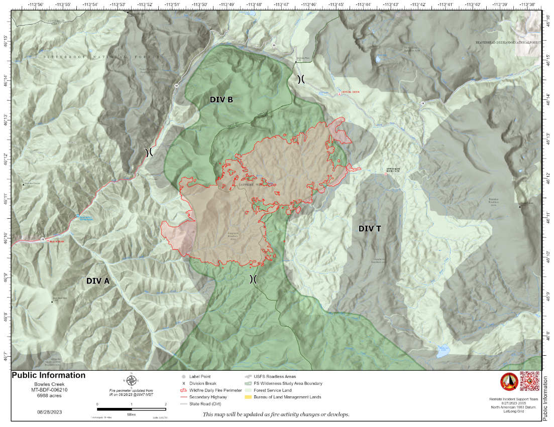
Bowles Creek Fire Update August 28 2023
Related Incident: Bowles Creek Fire
Publication Type: News
The Bowles Creek Fire is currently at 6,988 acres. Fire crews will be present along Hwy 38, Skalkaho Road, as fire operations and fire rehabilitation work continue. Motors are urged to drive slowly and be aware of increased fire traffic.
Completion of fire management objectives remains at 28%. Due to limited fire activity, fire personnel are beginning to focus on suppression rehabilitation to mitigate adverse resource effects resulting from fire suppression activities. Crew will focus on protection of wilderness study areas and roadless characteristics, surface erosion control, weed suppression, maintenance of forest improvements, and developed and undeveloped recreation sites. Sitework will encompass previously built handlines and other contingency lines, safety zones, drop points, fueling locations, spike camps, heliwells, and helispots (both related to helicopter operations).
Lane County Level 3 Evacuations as of 827
Related Incident: 2023 Horse Creek Fire
Publication Type: Closures
The following areas are on a Level 3 (GO NOW) evacuation notice:
?Horse Creek Rd. east of the Horse Creek Bridge.
?Foley Hot Springs
Klamath National Forest Fire Activity Update August 28 2023
Related Incident:
Publication Type: News
Public Information Officer: Jennifer Erickson
(530) 310-5690
**FINAL UPDATE**
Klamath National Forest Fire Activity Update – August 28, 2023
Yreka, Calif. – Limited visibility and smoky air will prevail across much of Northern California Monday as an inversion layer settles over the Klamath National Forest. Heavy smoke continues to conceal the locations of two unconfirmed and two small, confirmed fires first reported on the Happy Camp/Oak Knoll Ranger District on August 25th. Fire officials will continue searching for and evaluating ways to access these areas to determine suppression needs. Infrared flights are not showing any additional new fires beyond what has already been reported.
This will be the final update from the Klamath National Forest on fires not associated with the Happy Camp Complex unless significant changes to fire activity occur. A brief daily status report of active fires will be posted on the Klamath National Forest Facebook page: https://www.facebook.com/KlamathNF/.
Happy Camp/Oak Knoll District:
- The Red Fire was reported south of Red Hill on August 25th. To date, crews have been unable to locate the fire.
- The Vann Fire was reported three miles west of Elbow Springs in the Vann Creek Drainage on August 25th. To date, crews have been unable to locate the fire.
- The Dillon Fire is northwest of the North Fork of Dillon Creek. The acreage is unknown due to heavy smoke from the Elliot Fire. Fire officials are working to identify options to safely access the fire.
- The Donkey Fire is near Pony Peak and adjacent to the Elliot Fire. The acreage is unknown due to smoky conditions. Fire officials are working to identify options to safely access the fire due to its proximity to the Elliot Fire.
- The Berry Fire near Huckleberry Mountain is approximately 0.2 acres. The fire is controlled and in patrol status.
- The Capitan Fire near Capitan Mountain is approximately 2 acres. The fire is controlled and in patrol status.
- The Titus Fire in the Marble Mountain Wilderness south of Norcross Campground is approximately 67 acres. Smokejumpers are working hot spots and implementing a confine and contain strategy. The fire is in a remote area with low probability of continuing to spread due to natural barriers, sparse fuels, and previous burn scars.
Salmon/Scott River Ranger District:
- No active fires to report.
Goosenest Ranger District:
- No active fires to report.
Evacuation Orders and Warnings: Monitor CodeRED and the Siskiyou County Sheriff Facebook Page for current information.
Forest Closures:
- Happy Camp Ranger District Closure Map: https://www.fs.usda.gov/Internet/FSE_DOCUMENTS/fseprd1132183.pdf
- Oak Knoll and Scott River Ranger Districts Closure Map: https://www.fs.usda.gov/Internet/FSE_DOCUMENTS/fseprd1132187.pdf
The Pacific Crest Trail: The Pacific Crest Trail is closed between the Shelly Fork Junction and Seiad as part of an area closure under Forest Order 05-05-23-07. It is suggested that northbound through-hikers exit the trail at Etna Summit and resume northward travel from Seiad.
Highway 96 is open with one-way traffic control. This is subject to change based on current fire conditions. Visit quickmap.dot.ca.gov for the most up-to-date information on road closures.
Klamath National Forest Fire Information: https://inciweb.nwcg.gov/incident-information/caknf-2023-klamath-national-forest-august-lightning-fires
Happy Camp Complex Fire Information: https://inciweb.nwcg.gov/incident-information//caknf-2023-happy-camp-complex-klamath-nf
Fire Restrictions: https://www.fs.usda.gov/alerts/klamath/alerts-notices
*Please Obey All Evacuation Orders and Warnings*
# # #