
Perspectiva de Humo Smith River Complex 288 298
Related Incident: Smith River Complex
Publication Type: News
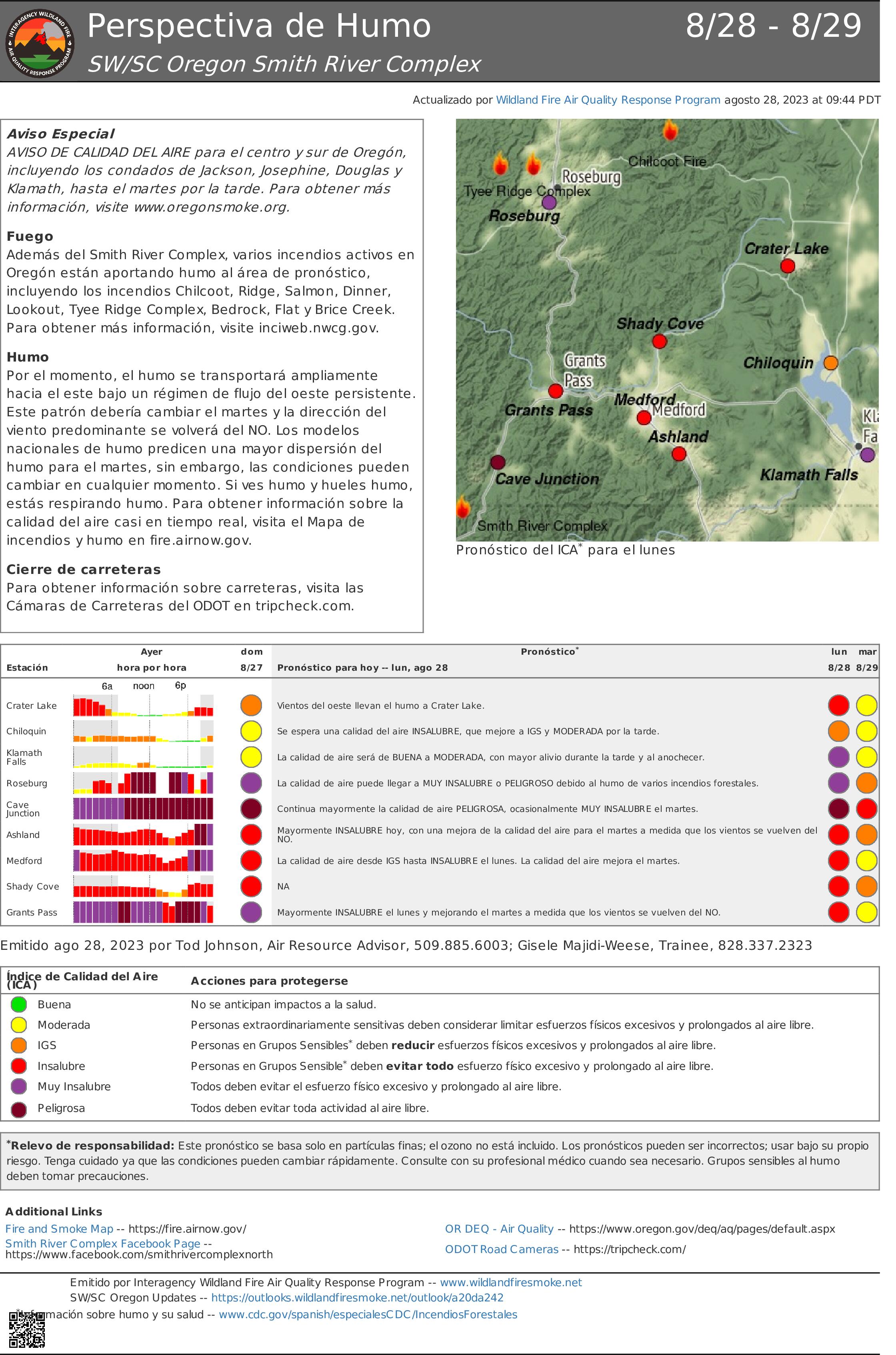
Declaración Especial
AVISO DE CALIDAD DEL AIRE para el centro y sur de Oregón, incluyendo los condados de Jackson, Josephine, Douglas y Klamath, hasta el martes por la tarde. Para obtener más información, visite www.oregonsmoke.org.
Incéndio
Además del Smith River Complex, varios incendios activos en Oregón están aportando humo al área de pronóstico, incluyendo los incendios Chilcoot, Ridge, Salmon, Dinner, Lookout, Tyee Ridge Complex, Bedrock, Flat y Brice Creek. Para obtener más información, visite inciweb.nwcg.gov.
Humo
Por el momento, el humo se transportará ampliamente hacia el este bajo un régimen de flujo del oeste persistente. Este patrón debería cambiar el martes y la dirección del viento predominante se volverá del NO. Los modelos nacionales de humo predicen una mayor dispersión del humo para el martes, sin embargo, las condiciones pueden cambiar en cualquier momento. Si ves humo y hueles humo, estás respirando humo. Para obtener información sobre la calidad del aire casi en tiempo real, visita el Mapa de incendios y humo en fire.airnow.gov.
Cierre de carreteras
Para obtener información sobre carreteras, visita las Cámaras de Carreteras del ODOT en tripcheck.com.
Bear Creek Daily Update 08282023
Related Incident: Bear Creek Fire
Publication Type: News
QUARTZ RIDGE & BEAR CREEK FIRES
August 28, 2023
Type 3 Team, Incident Commander: Nick Collard ICT3
Daily Update – 9:00 AM Grif Cochran ICT3 (T)
Highlights: Fire activity on the Bear Creek and Quartz Ridge depends mainly on cloud cover and precipitation over the fire area. Fire activity is expected to be minimal with smoldering, creeping, and backing where pockets of heat remain. Crews and air resources are available to respond quickly if conditions change.
Quartz Ridge Fire: 1,833 acres, increase of 34 acres | 73% of objectives achieved | 63 personnel assigned
The increased acreage on the Quartz Ridge Fire is due to updated aerial mapping. The southeastern and eastern edges of the fire continue to have pockets of heat with minimal to moderate fire behavior with some backing in steep terrain. The pocket of fire on the east side of Quartz Creek is within a rocky area and constrained by natural features. Direct control lines are being utilized to suppress accessible parts of the fire and indirect control lines are providing confinement on remote areas that present high safety risks to firefighters.
Bear Creek Fire: 443 acres, increase of 28 acres | 79% of objectives achieved | 11 personnel assigned
The Bear Creek fire has periodically received precipitation within the last few days and remains quiet with a few smokes visible. The increase in acreage is due to pockets of previously unburned fuels burning in the interior of the fire area and not due to fire spread on the perimeter.
Weather: High temperatures will be in the low 70s with afternoon minimum relative humidity of 30 to 45%. Light winds of less than 10 mph are forecast. Scattered thunderstorms are forecast for the afternoon and evening and can produce strong, gusty winds.
San Juan National Forest Temporary Area Closures: Closure orders are in effect and additional information can be found here. Roads and trails within area closures are Quartz Meadows Rd (NFSR#685), Mosca (Piedra) Road (NFS #631), Quartz Ridge Trail (NFST#570), Quartz Creek Trail (NFST#571), Weminuche Trail (NFS #592), Sand Creek Trail (NFS #593), NFS Trail #591, NFS Trail #524, NFS Trail #584; and NFS Trail # 673.
Restrictions: Stage 1 Fire Restrictions are in place for the San Juan National Forest and additional information is available here.
Fire Information
Office Hours: 8:00 AM – 8:00 PM Phone: 970-426-5370
Quartz Ridge Fire
Email: 2023.QuartzRidge@firenet.gov
InciWeb:
https://inciweb.nwcg.gov/incident-information/cosjf-quartz-ridge-fire
https://www.facebook.com/profile.php?id=100095556640621
Bear Creek Fire
Email: 2023.BearCreek@firenet.gov
Inciweb
https://inciweb.nwcg.gov/incident-information/cosjf-bear-creek-fire
https://www.facebook.com/profile.php?id=100095241777192
####
Quartz Ridge and Bear Creek Fires Daily Update August 28 2023
Related Incident: Quartz Ridge Fire
Publication Type: News
August 28, 2023
Type 3 Team, Incident Commander: Nick Collard ICT3, Grif Cochran ICT3 (T)
Daily Update – 9:00 AM
Highlights: Fire activity on the Bear Creek and Quartz Ridge depends mainly on cloud cover and precipitation over the fire area. Fire activity is expected to be minimal with smoldering, creeping, and backing where pockets of heat remain. Crews and air resources are available to respond quickly if conditions change.
Quartz Ridge Fire: 1,833 acres, increase of 34 acres | 73% of objectives achieved | 63 personnel assigned
The increased acreage on the Quartz Ridge Fire is due to updated aerial mapping. The southeastern and eastern edges of the fire continue to have pockets of heat with minimal to moderate fire behavior with some backing in steep terrain. The pocket of fire on the east side of Quartz Creek is within a rocky area and constrained by natural features. Direct control lines are being utilized to suppress accessible parts of the fire and indirect control lines are providing confinement on remote areas that present high safety risks to firefighters.
Bear Creek Fire: 443 acres, increase of 28 acres | 79% of objectives achieved | 11 personnel assigned
The Bear Creek fire has periodically received precipitation within the last few days and remains quiet with a few smokes visible. The increase in acreage is due to pockets of previously unburned fuels burning in the interior of the fire area and not due to fire spread on the perimeter.
Weather: High temperatures will be in the low 70s with afternoon minimum relative humidity of 30 to 45%. Light winds of less than 10 mph are forecast. Scattered thunderstorms are forecast for the afternoon and evening and can produce strong, gusty winds.
San Juan National Forest Temporary Area Closures: Closure orders are in effect and additional information can be found here. Roads and trails within area closures are Quartz Meadows Rd (NFSR#685), Mosca (Piedra) Road (NFS #631), Quartz Ridge Trail (NFST#570), Quartz Creek Trail (NFST#571), Weminuche Trail (NFS #592), Sand Creek Trail (NFS #593), NFS Trail #591, NFS Trail #524, NFS Trail #584; and NFS Trail # 673.
Restrictions: Stage 1 Fire Restrictions are in place for the San Juan National Forest and additional information is available here.
Fire Information
Office Hours: 8:00 AM – 8:00 PM
Phone: 970-426-5370
Quartz Ridge Fire
Email: 2023.QuartzRidge@firenet.gov
InciWeb:
https://inciweb.nwcg.gov/incident-information/cosjf-quartz-ridge-fire
https://www.facebook.com/profile.php?id=100095556640621
Bear Creek Fire
Email: 2023.BearCreek@firenet.gov
Inciweb
https://inciweb.nwcg.gov/incident-information/cosjf-bear-creek-fire
https://www.facebook.com/profile.php?id=100095241777192
Settings - change map background and toggle additional layers
Filter - control incident types displayed on map.
Zoom to your location
Reset map zoom and position
Could not determine your location.
Show Legend
 Wildfire
 Prescribed Fire
 Burned Area
Response
Burned Area
Response Other
Other
2023 Ridge Fire UNF
Unit Information
Incident Contacts
Settings - change map background and toggle additional layers
Filter - control incident types displayed on map.
Zoom to your location
Reset map zoom and position
Could not determine your location.
Show Legend
- Wildfire
- Prescribed Fire
- Burned Area
Response
- Other
2023 Ridge Fire UNF
Unit Information
Incident Contacts
Informacin al da del Incendio Smith River Complex North 28 de agosto 2023
Related Incident: Smith River Complex
Publication Type: News
Información al día para el Incendio Smith River Complex, lunes 28 de agosto, 2023
GRANTS PASS, Ore. – En horas de la tarde del sábado, los bomberos del turno nocturno trabajaron arduamente en el Incendio Smith River Complex North iniciando tácticas de operación de incendios en las líneas de fuego cercanas a Gilligan Butte. Es una situación crítica la quema del material de combustión situada entre la línea de incendio y el fuego para garantizar la seguridad de esta. Al mismo tiempo, los bomberos del turno nocturno tuvieron éxito en el trabajo realizado sobre la línea Oeste de Gilligan Butte dirigiéndose hacia la carretera 4402. El domingo, los bomberos del turno diurno, continuaron trabajando en extinguir el incendio a lo largo de la línea de contención primaria en el Sur y al lado Suroeste de Gilligan Butte, logrando alcanzar la carretera 4402. Actualmente los bomberos se encuentran realizando el mismo trabajo a lo largo de la carretera Sur 4402. Estos esfuerzos reducen la propagación del fuego que podrían impactar las residencias en el Sureste de Illinois Valley. Es necesario llevar a cabo un extenso trabajo de limpieza a lo largo de estas líneas antes de ser consideradas como “contenidas”.
Las operaciones aéreas siguen siendo limitadas por las condiciones de humo. Casi todo el día, la visibilidad alcanzo un cuarto de milla, haciendo dichas operaciones inseguras para la vida de los bomberos. Los trabajadores sobre el terreno también tuvieron dificultad por la poca visibilidad. Se pronostican vientos provenientes del Norte para los próximos días los cuales podrían empujar el humo hacia el Sur. El humo originado en otros incendios en el Noroeste del Pacifico podría afectar de una manera adversa en las operaciones a través del Incendio Smith River Complex North. Los bomberos continúan enfocándose en la protección de las comunidades y la infraestructura dispersada cercana a O’Brien y Takilma, a lo largo de Lone Mountain Road.
Permanece en pie un Nivel de Evacuación 3 – SALGA – para el área del Hwy. 199 al Sur de O’Brien a partir de la milla 38 hasta la frontera con California. Un Nivel de Evacuación 2, LISTO, ha sido establecido en O’Brien y para el área de Takilma. Un Nivel de Evacuación 1 – PREPARESE – fue extendido al Norte de Cave Junction. La Cruz Roja Americana ha formado albergues de Evacuación en Rogue Community College en Grants Pass. Los recursos pecuarios (animales) pueden ser transportados hacia la Feria municipal (Fairgrounds) de Josephine County.
Debido a un incremento en la actividad del Incendio, se recomienda al público en general que revisen el sitio de Rogue River Emergency Management https://rvem.org para obtener información al día y para registrarse para Citizen Alert, en caso de que todavía no lo haya realizado. Asimismo, podrá encontrar un mapa interactivo mostrando las respuestas iniciales de Incendio.
El Bosque Nacional de Rogue River-Siskiyou, ha implementado una orden de cierre para ciertas áreas y carreteras en el Incendio Smith River Complex. Para información adicional visite: https://tinyurl.com/2s4hymku. La Agencia para el Manejo de Tierras (Bureau of Land Management) en el Distrito de Coos Bay, ha anunciado un cierre de emergencia en el área al Sur de Waldo Road y para la carretera de Happy Camp dirigiéndose hacia la frontera de Oregon/California. Información más detallada puede verse en: https://www.blm.gov/orwafire
Se estará desarrollando una Reunión para la Comunidad el lunes, 28 de agosto, a las 6 de la tarde en la Escuela Secundaria de Illinois Valley: 625 E. River St., Cave Junction. Al mismo tiempo, se estará transmitiendo en vivo en la página de Facebook de Smith River Complex North 2023.
Happy Camp Complex Incident Update August 28 2023 800 am
Related Incident: 2023 Happy Camp Complex Klamath NF
Publication Type: News
VIRTUAL PUBLIC MEETING: A virtual public meeting for the Happy Camp Complex will be held on Monday, August 28th at 5:30 p.m. Fire personnel will provide an operational overview of the fire situation. The meeting will be live-streamed on Facebook (facebook.com/KlamathNF) and YouTube (youtube.com/@ciimt5). A Facebook account is not necessary to view the meeting.
WEST SIDE OVERVIEW (ACRES/CONTAINMENT): Elliot (7,877 acres, 2%), Malone (478 acres, 7%), Ufish (1,562 acres, 0%)
The fires on the west side of the Happy Camp Complex remained active overnight. The Elliot and Swillup fires have burned together and will now be known as the Elliot Fire. The Elliott Fire continues to back slowly down towards Highway 96. The north and south flanks of the fire are not expected to move much today. Last night, tactical firing operations were completed on the Malone Fire from the fire’s edge to Titus Peak, and on the Ufish Fire from the 16 Road northeast to Buzz Peak. Today, firefighters will continue to hold and improve fire lines.
EAST SIDE OVERVIEW (ACRES/CONTAINMENT): Head (6,844 acres, 35%), Block (0.1 acres, 100%), Townsend (81 acres, 100%), Den (294 acres, 100%), Scott (1,870 acres, 70%), Lake (199, acres, 5%)
Today, direct fire line construction will continue on the Head Fire. The focus is on building fire lines across the west and north flanks, near the community of Hamburg, and improving the existing fire line on the east side. On the Scott Fire, pockets of vegetation within the interior will continue to burn. CAL FIRE resources will work to improve the fire line and monitor Scott River Road.
EVACUATIONS: View current Siskiyou County evacuation orders and warnings by visiting: community.zonehaven.com. Siskiyou County residents are encouraged to sign up for rapid emergency notifications using the CodeRED emergency alert system. https://www.co.siskiyou.ca.us/emergencyservices/page/codered-emergency-alert
An evacuation center has been established at the Kahtishraam Wellness Center, 1403 Kahtishraam, Yreka, CA 95097. Call (530) 340-3539 if you have questions regarding the shelter.
ROAD CONDITIONS: State Route 96 is now open. One-way traffic control remains in place in several areas while crews work to repair damaged infrastructure, remove debris, and stabilize slopes. Delays at the locations with one-way traffic control will be up to 15 minutes. The road will be closed to the public east of Seiad daily from 8:00 a.m. to 9:00 a.m. and from 6:30 p.m. to 8:00 p.m. to facilitate fire traffic. For the exact locations of where this work is taking place, please use quickmap.dot.ca.gov. County road closures will be listed on the Siskiyou County Public Works website: https://www.co.siskiyou.ca.us/publicworks/page/closures-and-delays.
FOREST CLOSURE: Two closure orders have been implemented: Happy Camp Complex Emergency Fire Closure, No.05-05-23-06; Happy Camp Complex Emergency Fire Closure, No. 05-05-23-07. Please refer to https://www.fs.usda.gov/alerts/klamath/alerts-notices to view the orders and maps.
TEMPORARY FLIGHT RESTRICTION (TFR): A TFR has been established over the fire area. Flight restrictions include the use of drones. The operation of drones under the TFR is prohibited.
PACIFIC CREST TRAIL: The Pacific Crest Trail is closed between the Shelly Fork Junction and Seiad as part of an area closure under Forest Order 05-05-23-07. It is suggested that northbound through-hikers exit the trail at Etna Summit and resume northward travel from Seiad.
AIR QUALITY: For information regarding smoke impacts and what you can do to protect yourself, visit: https://www.airnow.gov/
Lookout and Horse Creek Fires Updated Fire Evacuation 08272023
Related Incident: Lookout Fire2023 Horse Creek Fire
Publication Type: Announcement
The following areas are being upgraded to a Level 3 (GO NOW) evacuation notice:
![]() Horse Creek Rd. east of the Horse Creek Bridge.
Horse Creek Rd. east of the Horse Creek Bridge.
![]() Foley Hot Springs
Foley Hot Springs
The following areas are being upgraded to a Level 2 (Be Set) evacuation notice:
![]() Hwy. 242 to the 220 spur
Hwy. 242 to the 220 spur
![]() Belknap Springs Rd. S.
Belknap Springs Rd. S.
![]() Yale Ln.
Yale Ln.
![]() Camp Yale Rd.
Camp Yale Rd.
The following areas remain on a Level 3 (GO NOW) evacuation notice:
![]() Mona Campground.
Mona Campground.
![]() Lookout Campground
Lookout Campground
![]() H.J. Andrews Headquarters
H.J. Andrews Headquarters
![]() The area west of Hwy. 126 from Scott Rd. north into Linn County. (Additional evacuations are in Linn County)
The area west of Hwy. 126 from Scott Rd. north into Linn County. (Additional evacuations are in Linn County)
Level 3 (GO NOW) Evacuation Notice: LEAVE IMMEDIATELY. Danger is current or imminent and you should evacuate now. If you choose to ignore this notice, emergency services may not be able to assist you further. DO NOT DELAY leaving to gather items or protect your home. THIS WILL BE THE LAST NOTICE YOU RECEIVE. Entry to evacuated areas may be denied until it is safe.
*Hwy 126 will be remaining open for traffic passing through for the time being.
--
The following areas remain on a Level 2 (Be Set) evacuation notice:
![]() Horse Creek Rd. west and north of Horse Creek Bridge.
Horse Creek Rd. west and north of Horse Creek Bridge.
![]() Hall Rd.
Hall Rd.
![]() Sullivan Ln.
Sullivan Ln.
![]() Alma Dr.
Alma Dr.
![]() Old Foley Ridge Rd.
Old Foley Ridge Rd.
![]() 5600blk of Delta Dr.
5600blk of Delta Dr.
![]() Areas south of McKenzie Hwy. from milepost 50.5 to milepost 54
Areas south of McKenzie Hwy. from milepost 50.5 to milepost 54
![]() Horse Creek Lodge
Horse Creek Lodge
![]() North Bank Rd.
North Bank Rd.
![]() Areas east of the McKenzie Bridge to, and including Drury Ln. north of Hwy. 126, but south of the McKenzie River.
Areas east of the McKenzie Bridge to, and including Drury Ln. north of Hwy. 126, but south of the McKenzie River.
![]() Areas north of Hwy. 126 east of the .5 mile mark on Mill Creek Rd. to the east end of Taylor Rd.
Areas north of Hwy. 126 east of the .5 mile mark on Mill Creek Rd. to the east end of Taylor Rd.
![]() Hwy 126 from the Hwy 242 junction to Scott Rd.
Hwy 126 from the Hwy 242 junction to Scott Rd.
![]() Belknap Hot Springs Rd.
Belknap Hot Springs Rd.
![]() The area east of Hwy. 126 from Scott Rd. north into Linn County. (Additional evacuations are in Linn County)
The area east of Hwy. 126 from Scott Rd. north into Linn County. (Additional evacuations are in Linn County)
![]() Areas north of Hwy. 126 west of the .5 mile mark on Mill Creek Rd. to Blue River
Areas north of Hwy. 126 west of the .5 mile mark on Mill Creek Rd. to Blue River
Reservoir Rd. at the 1501 junction.
![]() The area south of Hwy 126 to the McKenzie River from the east end of McKenzie River Dr. to the McKenzie River Bridge just east of Taylor Rd.
The area south of Hwy 126 to the McKenzie River from the east end of McKenzie River Dr. to the McKenzie River Bridge just east of Taylor Rd.
Residents on a Level 2 (Be Set) evacuation notice who need assistance with large animal sheltering should call Lane County Animal Services at 541-285-8227.
Level 2 means you must prepare to leave at a moment’s notice, and this may be the only notice that you receive. Public safety personnel cannot guarantee they will be able to notify you if conditions rapidly deteriorate.
--
The following areas remain on a Level 1 (Be Ready) evacuation notice:
![]() Areas south of Hwy. 126 from Blue River Reservoir Rd. east to the east end of McKenzie River Dr.
Areas south of Hwy. 126 from Blue River Reservoir Rd. east to the east end of McKenzie River Dr.
![]() The area south of Hwy 126 from the McKenzie River Bridge just east of Taylor Rd. to Scott Creek Rd.
The area south of Hwy 126 from the McKenzie River Bridge just east of Taylor Rd. to Scott Creek Rd.
![]() McKenzie River Dr. and areas directly to the south and east.
McKenzie River Dr. and areas directly to the south and east.
Level 1 means you should be aware of the danger that exists in your area, monitor local media outlets and telephone devices to receive further information.
*Evacuation notices are also in effect in Linn County related to the Lookout Fire. Visit www.LinnSheriff.org or @LinnSheriff on Facebook for evacuation notices within Linn County.
This is the time for preparation and precautionary movement of persons with special needs, mobile property, pets and livestock.
An evacuation map is available at www.LaneCounty.org/LookoutFire
Residents are encouraged to sign up for emergency alerts at www.LaneAlerts.org
Ridge Doris Point and Tin Soldier Fires Daily Update August 28 2023
Related Incident:
Publication Type: News
Warming and Drying Trend Continues on Ridge, Doris Point, and Tin Soldier Fires
August 28, 2023 Daily Update
Ridge Fire
Location: 6 miles southeast of Hungry Horse
Size: 3665 acres
Percent Contained: 76%
Cause: Lightning
Start Date: July 30th, 2023 @ 3:45 PM
Personnel Assigned: 407
Doris Point Fire
Location: 8 miles south of Hungry Horse
Size: 1597 acres
Percent Completed: 68%
Cause: Lightning
Start Date: July 30th, 2023 @ 3:45 PM
Personnel Assigned: 26
Tin Soldier Fires
Location: 17 miles east of Swan Lake
Size: 8165 acres
Percent Completed: 81%
Cause: Lightning
Start Date: July 30th, 2023 @ 3:45 PM
Personnel Assigned: 79
Highlights:
Warm and dry conditions today and tomorrow will result in increased fire activity on the Doris and Tin Soldier Fires, with the southwest corner of the Doris Point Fire experiencing backing, flanking, and some upslope movement. Minimal heat remains on the Ridge Fire. Firefighter activities will focus on removing equipment that is no longer needed and repairing areas impacted by earlier suppression activities, as well as ongoing monitoring and patrolling.
Operations:
Ridge Fire:
Fire crews are working to clean up and repair areas impacted by earlier suppression efforts. Repair activities include spreading chip piles and building water bars on handlines to reduce the likelihood of future erosion. Ground resources and aerial imagery has observed minimal heat coming from the Ridge Fire.
Doris Point Fire:
Structure protection equipment has been removed from the Doris Point Fire north of the Lost Johnny area, but remains in place at Lost Johnny Point and boat launch. Weather over the next two days will provide conditions for fire smoldering as well as backing, flanking, and some upslope movement on the southwest corner of the Doris Point Fire. Increased fire behavior is not anticipated to impact structures or developed areas. Crews will continue to remove unneeded equipment and snags.
Tin Soldier Fire:
The mechanical thinning project will continue to create shaded fuel breaks north of Spotted Bear. Crews are broadcasting brush and preparing logs to be removed. Extra equipment will be removed from the Heinrude community today. Structure protection remains in the Spotted Bear area where crews continue to maintain and test equipment.
Weather and Fire Behavior:
The weather continues to be dominated by the ridge of high pressure causing warm and dry conditions over the fire with terrain driven winds. Thermal belts will develop over the fire again tonight. Tuesday will be the warmest and driest day of the week as a cold front approaches the region and brings an uptick in winds. Tuesday high temperatures will be 90-95° at lower elevations and 79-84° on higher slopes.
The Hungry Horse Reservoir is closed to all public access, including both the east and west side roads. The Forest Closure Order that includes the Heinrude Community remains in effect. As firefighting efforts continue on the Ridge Fire, Doris Point Fire, and Tin Soldier Fire the closure is in place to provide for public and firefighter safety. https://www.fs.usda.gov/alerts/flathead/alerts-notices/?aid=82283
Additional Information:
Residents should stay alert for changing conditions and visit https://www.ready.gov/wildfires for preparing for wildfires. The Tin Soldier Complex Incident information will now be updated on the Ridge Fire Inciweb page. Moving forward, please refer to https://inciweb.nwcg.gov/incident-information/mtfnf-ridge-fire for information on the Tin Soldier Complex.
Fire Information: 406-998-6074 (8:00 am to 8:00 pm)
Email: 2023.ridge@firenet.gov
https://www.facebook.com/ridge.fire.information https://www.youtube.com/@2023ridgefire
Lookout Fire Updated Closure 08272023
Related Incident: Lookout Fire2023 Horse Creek Fire
Publication Type: Closures
The closure order for the Lookout Fire has been expanded due to increasing fire behavior and two new fires – Horse Creek and Pothole. Some key recreation areas remain open:
• Highway 126 and Highway 20 remain open; for the latest status on these highways, visit TripCheck
• Road 19 (Aufderheide Drive) remains open, including Terwilliger Hot Springs
• House Rock and Lost Prairie Campgrounds remain open
• Clear Lake Resort remains open
Many new recreation sites and trails have been added to the closure area, including:
• Cold Water Cove, Slide Creek and Sunnyside Campgrounds
• Many Mt. Washington and Three Sisters Wilderness trailheads
• The King Castle/O’Leary/Olallie Trail complex
• Most of the Santiam Wagon Road
Popular hunting areas are also now closed. All hunters should check the closure map to see the full extent of the closure.
For the entire closure order and map, please go to the Willamette National Forest webpage at: https://www.fs.usda.gov/alerts/willamette