
Firing operations to take place near Patricks Knob on Sunday August 27
Related Incident:
Publication Type: Announcement
On Sunday afternoon, August 27, fire crews will conduct limited firing operations to remove unburned fuels and increase containment in the Patrick's knob area.
Please be aware that these operations will generate smoke visible from the valley.
We will continue to keep you updated on any developments and provide you with any new information.
If you have any questions or concerns, feel free to call our fire information line: 406-345-5972
Lookout Fire Daily Update 8272023
Related Incident: Lookout Fire
Publication Type: News
August 27, 2023
Morning Update
Size: 21,135 acres
Start Date: August 5, 2023
Cause: Lightning
Containment: 16%
Point of origin: 3 miles North of McKenzie Bridge, OR
Total personnel: 999
Resources: 53 engines l 19 crews l 18 bulldozers l 30 water tenders l 11 masticators l 7 helicopters
Current Situation: Firefighters continue efforts to suppress fire activity in the Horse Creek drainage. Last night, the fireline on the western edge of the Horse Creek Fire held and will continue to be secured throughout the day today. The primary growth of the fire occurred on the northern and eastern edges. Helicopters have dropped over 50,000 gallons of water and retardant and will continue as needed. Some resources assigned to the Lookout Fire have been diverted to the Horse Creek Fire as suppressing this and other new starts are the highest priority. The Horse Creek fire is estimated to be about 100 acres in size. A new lightning caused fire (Pothole Fire) is also being managed by this Incident Management Team. It is located about five miles southeast of the community of McKenzie Bridge. Firefighters are gathering on-the-ground information on this fire to develop a suppression plan today.
On the Lookout Fire east flank, crews are prepared to respond to potential spot fires over control lines as the main fire backs downhill toward Highway 126. On the southern flank above North Bank Road, firing operations have been successful. On the southwestern flank moving north up Mill Creek Road, firefighters are steadily increasing containment as strategic firing operations followed by mop-up progresses. Ahead of the northern flank, hand crews and engine crews, tree-fallers and heavy equipment are preparing roads to be used as control lines. Unmanned Aerial System (UAS) or drones are flying through the smoke to provide infrared heat imaging to locate additional threats to control lines. Drones are also supporting firing operations in areas that are hard to access, which reduces risk to firefighters.
Structural protection firefighters are in place to protect homes affected by these fires. Firefighters and law enforcement officers will maintain a presence in evacuated areas. OSFM resources remain available to return to the incident should the need arise.
The weather forecast for today is similar to yesterday, with hot, dry conditions and light east and northwest winds battling over the fire area, which will increase fire activity most notably on the northeastern flank.
Evacuation Centers: An evacuation center is in place at Westridge Middle School in Oakridge for evacuees and small pets from the Bedrock and Lookout Fires. A large animal shelter is established at the Lane County Fairgrounds in Eugene.
Evacuations: For Lane County evacuation updates visit: https://www.lanecountyor.gov/cms/one.aspx?pageId=19729054
Level 3 (Go Now) evacuation notice for Mona Campground, Lookout Campground, H.J. Andrews Headquarters, the area west of Hwy. 126 from Scott Rd. north into Linn County.
There is a Level 2 (Be Set) for Horse Creek Road, Hall Rd, Sullivan Ln., Alma Dr., Old Foley Ridge Rd., 5600blk of Delta Dr. Areas south of McKenzie Hwy. from milepost 50.5 to milepost 54, Horse Creek Lodge, Foley Hot Springs, North Bank Rd. Areas east of the McKenzie Bridge to, and including Drury Ln. north of Hwy. 126, but south of the McKenzie River. Areas north of Hwy. 126 east of the .5 mile mark on Mill Creek Rd. to the east end of Taylor Rd. Hwy 126 from the Hwy 242 junction to Scott Rd. Belknap Hot Springs Rd. The area east of Hwy. 126 from Scott Rd. north into Linn County. Areas north of Hwy. 126 west of the .5 mile mark on Mill Creek Rd. to Blue River, Reservoir Rd. at the 1501 junction, the area south of Hwy 126 to the McKenzie River from the east end of McKenzie River Dr. to the McKenzie River Bridge just east of Taylor Rd.
There is a Level 1 (Be Ready) evacuation notice for areas south of Hwy. 126 from Blue River Reservoir Rd. east to the east end of McKenzie River Dr, The area south of Hwy 126 from the McKenzie River Bridge just east of Taylor Rd. to Scott Creek Rd., McKenzie River Dr. and areas directly to the south and east, Belknap Springs Rd. South.
For Linn County evacuation updates visit: https://www.linnsheriff.org/
In Linn County, there is a Level 3 (Go Now) from Olallie Campground and the Linn County line, north and west of Highway 126, extending north to Ice Cap Campground and Trailhead at Carmen Reservoir, then west to encompass Lakes End Campground and trail system at Smith Reservoir. Tamolitch Falls/Blue Pool is also within this LEVEL 3 (GO NOW) Evacuation Zone
A Level 2 (Be Ready) for the areas of Ice Cap Campground and Trailhead at Carmen Reservoir, north to where Ikenick Creek and Highway 126 intersect, and extending to the east in line with other evacuation boundaries enacted, and west along Highway 126.
Level 1 (Be Ready) evacuation zone for the areas north of where Ikenick Creek and Highway 126 intersect, extending east to the Willamette National Forest boundary, and north in line with Highway 20. This includes all areas around Clear Lake, and Clear Lake Campground, as well as Fish Lake and Campground.
Road Closures: Highway 242, McKenzie Highway, is closed between milepost 61-76, 14 miles west of Sisters, Oregon to just east of the junction with Highway 126. Highway 126 is currently open. Please monitor Trip Check for any updates at: https://tripcheck.com/
Forest Closures: The Willamette National Forest is implementing new Forest closures due to the increased fire activity. Closures can be found at: https://www.fs.usda.gov/detail/willamette/alerts-notices/?cid=fseprd552029 Restrictions: Fire Restrictions are in place on the Willamette National Forest: https://www.fs.usda.gov/willamette
Smoke Outlook: Available at: https://outlooks.wildlandfiresmoke.net/outlook/4c92bc1a?
Information Line: 541-215-6735 8am-8pm | Email: 2023.lookout@firenet.gov
Facebook: https://www.facebook.com/LookoutFire2023
Inciweb: https://inciweb.nwcg.gov/incident-information/orwif-lookout-fire
Smith River Complex South August 27 2023
Related Incident: Smith River Complex
Publication Type: News
Fire Update Smith River Complex South 8/27
Start date: Aug 15, 2023
Location: Six Rivers National Forest
Cause: Lightning
Acres: 67,079
Containment: 0%
Personnel: 2,520
Gasquet, Calif., August 27, 2023. The Del Norte County Sheriff’s Department, in collaboration with the Del Norte County Office of Emergency Services and California Interagency Incident Management Team 15, have lowered the evacuation level in Low Divide at Highway 197 from mile marker 1 to mile marker 13, to level 2. Residents are urged to remain vigilant as the evacuation level could be raised again if fire activity and conditions warrant such changes. Firefighters will remain in the area to continue prepping structures and lines, so please allow them the necessary space to complete their work.
Smoky conditions yesterday morning gave way to generally cool weather all around the fire area. Resources have been taking advantage of the favorable conditions by increasing containment on the fires throughout the complex. Crews were able to complete direct handline around a large portion of the Corral fire. Two days ago, a helicopter was able to land near the High Plateau on the Diamond fire. The plan is to insert helitack modules into the Diamond fire where they will complete containment lines around the fire.
Crews were able to continue firing operations down the Pacific Power line corridor to the hand line, just north of Gasquet at the base of Stony Creek. The plan is to continue this firing operation over the next several days, to secure this corner of the fire before adverse easterly winds arrive in the middle of next week. Crews also initiated firing operation along the constructed line that connects French Hill Road with Hwy 199. This operation is hoped to be completed today. These actions will make it less likely the fire will reach structures along French Hill Road.
Potential control lines have been placed from French Hill Road, using the 17N40 Road to the south to Craigs Creek. Today, a potential control line will be built on the south side of Craigs Creek where it will connect with the 2015 Coon fire. These historic fires have acted as barriers to fire spread and have been incorporated into the overall containment strategy of the Smith Rivers Complex. This is the main reason the Island and Prescott fires have seen minimal growth over the last several days as they are entirely burning in the 2017 Oak fire and are holding at 315 and 589 acres, respectively.
Evacuations
All evacuation orders are issued by the Del Norte County Sheriff's Office. If you are in the Del Norte County, area please sign up for their Community Alert System to receive emergency notifications. Evacuation levels as of August 27, 8:00 a.m., as follows:
Level 3 “Go Now”: Patrick Creek, Little Jones Creek, Copper Creek Drainage, Coon Creek/ 16n19 17n07, Washington Flat, Pioneer Road, Panther Flat Campground Area, all communities between Slant Bridge Road north to the Oregon Border along Highway 199, French Hill Road.
Level 2 “Be Set”: Low Divide, High Divide, Rowdy Creek, Big Flat/Rock Creek
Level 1 “Be Ready”: Hiouchi from Slant Bridge to the east end of North Bank Road
Closures
South Fork Road is open to residents only. Resident must provide proof of residency.
Rowdy Creek Road remains closed at the top of Low Divide.
Howland Hill Road (Residents Only)
County road 316, Shelly Creek,
County Road 315 Holiday Mine
County Road 311 Old Gasquet Toll Road
Forest Service Roads 16N19 and 17N07
U.S. Highway 199 is closed in Del Norte County from Slant Bridge Road to Oregon Mountain Road (PM 16 to 31) due to the fire activity. A hard closure is in place on U.S. 199 at the Agriculture Station near the Oregon border. For the latest road conditions please visit quickmap.dot.ca.gov
Effective Sunday, August 20, 2023, the Six Rivers National Forest has issued a forest-wide closure order. https://www.fs.usda.gov/detail/srnf/notices/?cid=FSEPRD1096395
The American Red Cross has a shelter at the Del Norte County Fairgrounds (421 US-101 N, Crescent City, CA 95531) for those displaced by evacuations. Red Cross disaster workers are partnering with local officials to help ensure evacuees receive necessities, including food, water, and shelter.
More Information
Smith River Complex Inciweb: inciweb.nwcg.gov/incident-information/casrf-smith-river-complex
Six River National Forest: https://www.facebook.com/SixRiversNF
Del Norte Office of Emergency Services: https://www.facebook.com/DelNorteOfficeOfEmergencyServices
Del Norte County Sheriff’s Office: https://www.facebook.com/DelNorteCountySheriffDepartment
Smith River Complex North: https://www.facebook.com/smithrivercomplexnorth
Rogue River-Siskiyou National Forest: https://www.facebook.com/R6RRSNF/
Josephine County Emergency Management: https://www.facebook.com/josephinecountyEM
For an interactive evacuation map please visit: https://rvem.org/.
Smith River Complex North public meeting August 28
Related Incident: Smith River Complex
Publication Type: Announcement
Smith River Complex North is holding a public meeting on Monday, August 28 at 6:00 p.m.
The meeting will be at:
Illinois Valley High School
625 E River Street
Cave Junction, Oregon 97523
The public meeting will be simulcast on the Smith River Complex North 2023 Facebook page, and recorded for later viewing. Fire managers and cooperators will present fire updates and answer questions.
Tyee Ridge Complex Morning Update 082723
Related Incident: Tyee Ridge Complex
Publication Type: Announcement
Acreage: 1,816
Containment: 0%
Location: Douglas County
Cause: Under investigation
Last night, crews saw active fire growth on the Cougar Creek and Rattlesnake Ridge fires which grew together. There was also very active fire, including uphill runs on the Lighthouse 3 and 4 fires. Overnight, OSFM crews provided protection from active fire to homes near the fires. There has been no loss to any homes or structures to date. There is potential for significant fire growth on some of the fires over the next couple of days. One new fire start was found last evening and added to the complex.
Challenges facing firefighters include steep terrain, limited road access, warm weather, heavy smoke and extremely dry conditions. Ten helicopters have been dropping water on the fires in support of ground forces, but heavy smoke and low visibility has limited use of fixed-wing aircraft. Crews will continue to support the local district with initial attack when requested. Weather over the fires is expected to remain in the high 70s to low 80s with light winds today with continued heavy smoke.
Firefighters and equipment will continue arriving today from around Oregon and nationally to support forces on the Complex, which is about 20 road miles NW of Roseburg. Two more Oregon State Fire Marshal structural task forces—one from Clatsop County this morning and one from Yamhill this afternoon—are expected to join the five already at the fire. They are focused on preparing structures to minimize fire risk.
A total of 73 residences are under Level 3 (Go Now!) evacuation orders and 31 at Level 2 (Be Set). An estimated 125 people have evacuated from the Hubbard Creek Road area west of the town of Umpqua. Douglas County Emergency Management has worked with the Red Cross to set up a shelter for evacuees at the Oakland Elementary School at 499 NE Spruce Street in Oakland. To shelter livestock, contact Douglas County Fairgrounds at 541-957-7010. Companion pets can be sheltered at Saving Grace animal shelter in Roseburg. Evacuation areas remain unchanged. To view the current evacuation information map, go to www.dcso.com/evacuations
Community Meeting Scheduled: The Tyee Ridge Complex management teams will be holding a community meeting tomorrow, Monday, Aug. 28, 2023 at 7 p.m.
Location: Roseburg Country Club, 5051 Garden Valley Road, Roseburg
Structures Threatened: 109
Personnel: 472
Evacuations: Level 3 (Go Now!) from the 11000 block of Hubbard Creek Rd. to Millwood Dr. Level 2 (Be Set) from Hubbard Creek Rd. from the Millwood Dr. intersection to Melqua Rd.
Visit our Facebook Page: https://www.facebook.com/tyeeridgecomplex/
Public and Media Information Line: (541) 625-0328
Email: Tyee.Ridge.Information@gmail.com
###
Ridge Creek Fire Update for August 27 2023
Related Incident:
Publication Type: News
Location: Approximately 3.5 miles east of the north tip of Hayden Lake, along the Hayden Creek Road (Forest Service Road 437) from the Ridge Creek drainage to South Chilco Mountain.
Start Date: 8/3/2023 Cause: Undetermined Size: 4,359 acres Containment: 32% Total Personnel: 512 Heavy Equipment: 20 Engines: 16 Crews: 14
A Ridge Creek Fire virtual community briefing will take place on Facebook Live today at 3 p.m. Please join us for the live event on the Idaho Panhandle National Forest Facebook page https://www.facebook.com/USFSIPNF or check back later in the day to watch the recording.
FIRE STATUS
Firefighters continue to meet objectives and contain the Ridge Creek Fire. Resources in the southern division continue to hold and improve the primary line, as well as mop up. They are also using information from the overnight infrared flight to find heat and extinguish it. The division expects to move into patrol status in the near future.
On the eastern flank, hand crews are working in conjunction with heavy equipment to improve roads and shore up fuel breaks in case fire activity picks up. Physical resources are being inventoried.
Most of the planned mastication work on the north end of the fire has been completed and crews have transitioned into chipping operations. Firefighters are working to identify ridges and roads for possible direct fire line construction. If it is safe and weather conditions allow, crews may do some selective direct attack on the fire.
Resources have completed dozer line on the fire’s northwest edge. This will provide a fuel break to limit fire spread in this area.
Containment lines are complete on the southwest flank. Resources are seeking opportunities to access and extinguish areas of heat in the fire’s interior and finalize contingency lines.
Structure protection continues structure triage with local cooperators in the Bunco Road community.
WEATHER AND FIRE BEHAVIOR
A strong warming and drying trend continues in the region. Temperatures approaching or surpassing 90 degrees are expected with humidity dipping into the teens. Light winds are forecast. No precipitation is expected in the fire area over the next two days. Smoldering and creeping fire behavior is anticipated, though an isolated single tree torching may be visible. Fire growth should be modest.
Air quality information is available at www.airnow.gov and www.wildlandfiresmoke.net.
EVACUATION STATUS
The Kootenai County Office of Emergency Management evacuation status for the Bunco area remains the same (SET or Level 2). More information is available at https://www.kcsheriff.com/186/Emergency-Management.
CLOSURES AND SPECIAL MESSAGES
A daylight hours temporary flight restriction remains in place https://tfr.faa.gov/save_pages/detail_3_3347.html.
The Coeur d’Alene Dispatch Zone has issued Stage II Fire Restrictions for the Idaho Panhandle, including Kootenai County.
Closure Order #01-04-03-23-003 for the Idaho Panhandle National Forest remains in place for Forest Service land north of Forest Service Road (FSR) 206, west of FSR 209 and FSR 385, and south of FSR 332; and for Forest Service land surrounding and north of the Yellowbanks Creek area and west of FSR 1535.
The closure includes all Forest Service Roads within the area:
• FSR 332, 385, 392, 428A, 437,1507, 1511,1530, 1552 and 1587.
• FSR 206 north of the junction with FSR 406.
• FSR 406 north of the junction with FSR 206.
• Bunco Road/FSR 332 from National Forest boundary east to the junction of FSR 385.
• FSR 385 from junction with Bunco Road/FSR 332 south to the junction of FSR 209 and FSR 794. It also includes Forest Service Trails 69, 78, 234, 577 and 802.
This order is necessary for public and firefighter safety due to heavy fire traffic and equipment in the area.
Informacin al da del Incendio Smith River Complex North 27 de agosto 2023
Related Incident: Smith River Complex
Publication Type: News
Información al día. Incendio Smith River Complex North, domingo, 27 de agosto, 2023
GRANTS PASS, Ore. – Por la tarde del sábado, se dio una incrementación del incendio Kelly. La propagación del fuego fue impulsada por ráfagas de vientos hasta de 18 mph, con la persistencia de clima cálido y condiciones extremadamente secas. Se estableció un nuevo incendio al Oeste de Gilligan Butte el cual no logro romper la línea de contención primaria que protege Illinois Valley cercana a O’Brien. El personal del Incendio considera de gran prioridad la protección de la infraestructura en el área, así como asegurar que el fuego no cruce la línea de contención primaria. Los bomberos se encuentran trabajando arduamente, día y noche. Tres grupos adicionales de expertos en Incendios (Hot Shot) arribaron en la zona para apoyar con los esfuerzos en la contención del fuego. Otras escuadrillas continúan construyendo líneas de incendio directas e indirectas desde el área de los drenajes de Rough y Ready Creek al Noreste del fuego, al Sur y al Oeste de Gilligan Butte a lo largo de la carretera 4402 y dirigiéndose hacia el Hwy. 199. Al mismo tiempo se encuentran edificando líneas al Sureste del Hwy. 199 en el área de Elk Creek al Sur de la frontera de California, siguiendo la carretera 18N11 hacia el camino 444. El pronóstico del clima abarcando hasta el jueves, avisa que se estará presentando un patrón similar de neblina por las mañanas y la persistencia de humo pesado sobre el área. Este fenómeno resultara en una calidad pobre en el aire, baja visibilidad y limitara las operaciones aéreas.
Permanece en pie un Nivel de Evacuación 3 – SALGA – para el área del Hwy. 199 al Sur de O’Brien a partir de la milla 38 hasta la frontera con California. Un Nivel de Evacuación 2, LISTO, ha sido establecido en O’Brien y para el área de Takilma. Un Nivel de Evacuación 1 – PREPARESE – fue extendido al Norte de Cave Junction. La Cruz Roja Americana ha formado albergues de Evacuación en Rogue Community College en Grants Pass. Los recursos pecuarios (animales) pueden ser transportados hacia la Feria municipal (Fairgrounds) del pueblo.
Debido a un incremento en la actividad del Incendio, se recomienda al público en general que revisen el sitio de Rogue River Emergency Management https://rvem.org para obtener información al día y para registrarse para Citizen Alert, en caso de que todavía no lo haya realizado. Asimismo, podrá encontrar un mapa interactivo mostrando las respuestas iniciales de Incendio.
El Bosque Nacional de Rogue River-Siskiyou, ha implementado una orden de cierre para ciertas áreas y carreteras en el Incendio Smith River Complex. Para información adicional visite: https://tinyurl.com/2s4hymku. La Agencia para el Manejo de Tierras (Bureau of Land Management) en el Distrito de Coos Bay, ha anunciado un cierre de emergencia en el área al Sur de Waldo Road y para la carretera de Happy Camp dirigiéndose hacia la frontera de Oregon/California. Información más detallada puede verse en: https://www.blm.gov/orwafire
Se estará desarrollando una Reunión para la Comunidad el día Lunes, 28 de agosto, a las 6 de la tarde en la Escuela Secundaria de Illinois Valley: 625 E. River St., Cave Junction. Al mismo tiempo, se estará transmitiendo en vivo en la página de Facebook de Smith River Complex North 2023.
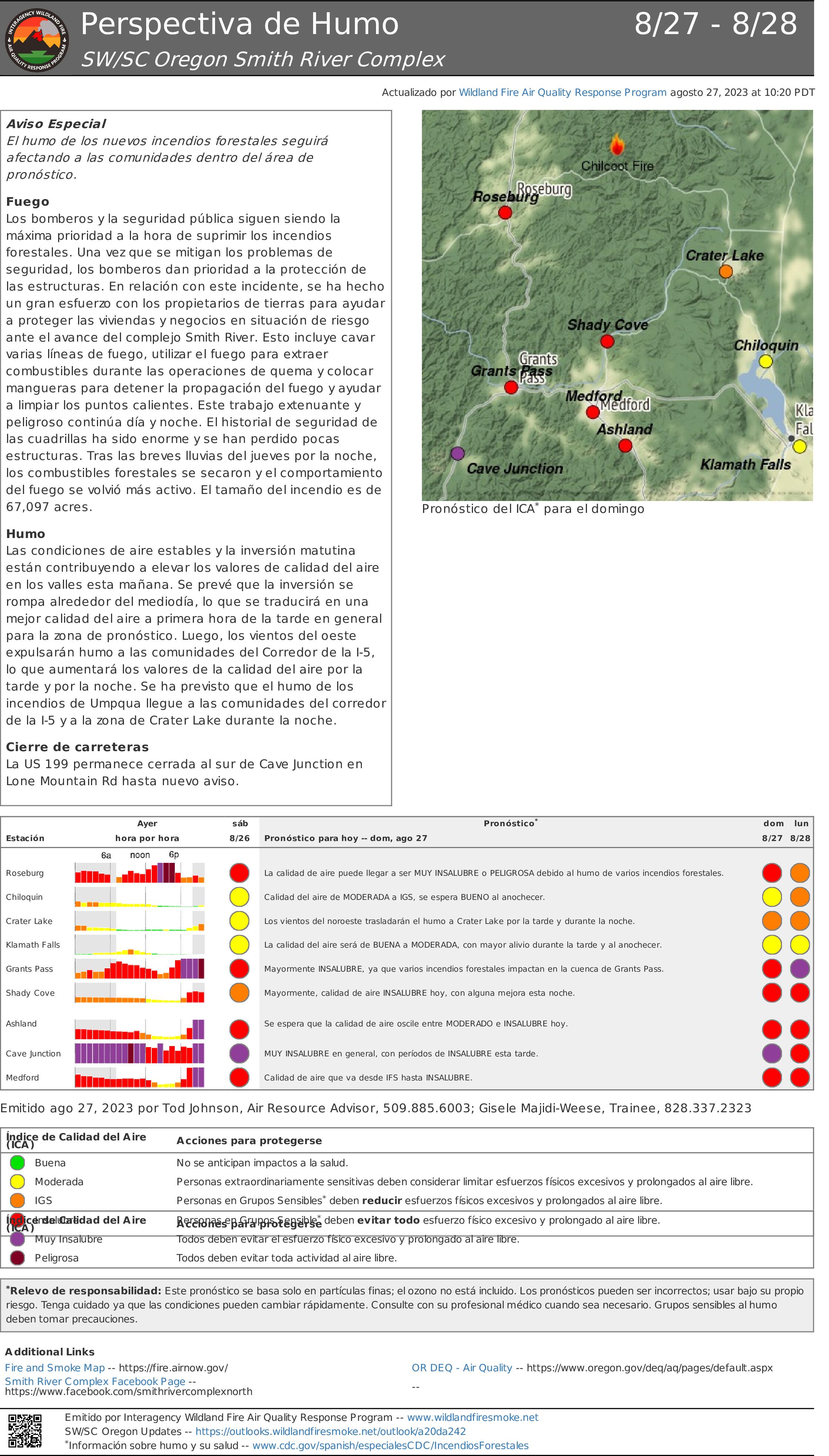
Perspectiva de Humo 827 828 Smith River Complex
Related Incident: Smith River Complex
Publication Type: News
Aviso Especial
El humo de los nuevos incendios forestales seguirá afectando a las comunidades dentro del área de pronóstico.
Fuego
Los bomberos y la seguridad pública siguen siendo la máxima prioridad a la hora de suprimir los incendios forestales. Una vez que se mitigan los problemas de seguridad, los bomberos dan prioridad a la protección de las estructuras. En relación con este incidente, se ha hecho un gran esfuerzo con los propietarios de tierras para ayudar a proteger las viviendas y negocios en situación de riesgo ante el avance del complejo Smith River. Esto incluye cavar varias líneas de fuego, utilizar el fuego para extraer combustibles durante las operaciones de quema y colocar mangueras para detener la propagación del fuego y ayudar a limpiar los puntos calientes. Este trabajo extenuante y peligroso continúa día y noche. El historial de seguridad de las cuadrillas ha sido enorme y se han perdido pocas estructuras. Tras las breves lluvias del jueves por la noche, los combustibles forestales se secaron y el comportamiento del fuego se volvió más activo. El tamaño del incendio es de 67,097 acres.
Humo
Las condiciones de aire estables y la inversión matutina están contribuyendo a elevar los valores de calidad del aire en los valles esta mañana. Se prevé que la inversión se rompa alrededor del mediodía, lo que se traducirá en una mejor calidad del aire a primera hora de la tarde en general para la zona de pronóstico. Luego, los vientos del oeste expulsarán humo a las comunidades del Corredor de la I-5, lo que aumentará los valores de la calidad del aire por la tarde y por la noche. Se ha previsto que el humo de los incendios de Umpqua llegue a las comunidades del corredor de la I-5 y a la zona de Crater Lake durante la noche.
Cierre de carreteras
La US 199 permanece cerrada al sur de Cave Junction en Lone Mountain Rd hasta nuevo aviso.
Ridge Doris Point and Tin Soldier Fires Daily Update August 27 2023
Related Incident:
Publication Type: News
Ridge Fire
Location: 6 miles southeast of Hungry Horse
Size: 3665 acres
Percent Contained: 76%
Cause: Lightning
Start Date: July 30th, 2023 @ 3:45 PM
Personnel Assigned: 375
Doris Point Fire
Location: 8 miles south of Hungry Horse
Size: 1587 acres
Percent Completed: 58%
Cause: Lightning
Start Date: July 30th, 2023 @ 3:45 PM
Personnel Assigned: 58
Tin Soldier Fires
Location: 17 miles east of Swan Lake
Size: 8165 acres
Percent Completed: 20%
Cause: Lightning
Start Date: July 30th, 2023 @ 3:45 PM
Personnel Assigned: 138
Highlights: The warm and dry weather contributed to an increase in smoke and minimal fire activity. Some smoldering with potential creeping is expected to continue today. The Unmanned Aerial Systems (UAS) group has been flying over the area and assisting with identifying hot spots. Inciweb information for the Tin Soldier Complex is now updated on the Ridge Fire Inciweb page. Southwest Area Incident Management Team 1 is hosting a community meeting tonight at the Glacier Bible Camp at 5:00 PM. The meeting will be live streamed and recorded on the Ridge Fire Facebook Page and YouTube.
Operations:
Ridge Fire: The UAS flight on Saturday saw very little heat on the Ridge Fire. Firefighters will continue to monitor and patrol for any potential heat. Equipment, such as hose lays and pumps, have been removed from areas showing no fire activity. Crews continue with repair work on areas impacted by fire suppression activities.
Doris Point Fire: Doris Point had a slight increase in fire activity on Saturday. Hot spots inside the perimeter of the fire and some creeping on the west side were observed. This fire behavior is not impacting any areas of concern. The UAS group plans to fly over Doris Point today and will provide a clearer picture of hot spot locations. Today’s activities will encompass more patrolling and snag removal. Backhaul of firefighting equipment that is no longer needed has also begun.
Tin Soldier Fire: Creeping fire behavior is expected to increase on the Bruce fire with the rise in temperature. Personnel are maintaining pump operations around structures and other values at risk. Mechanical thinning is ongoing with the goal of completion of the project at Soldier Creek. Monitoring of the Sullivan fire continues, little or no heat has been identified in the last few days.
Weather and Fire Behavior:
Today we resumed the warming and drying trend as the ridge of high pressure regained control of the weather pattern.
Forecasting for next couple of days shows the strong warming and drying trend continuing with the peak occurring Monday.
Regionwide temperatures approaching or surpassing 90 is expected with lowland humidity dipping into the teens. While we have 2 of the three factors leading to critical fire conditions, winds are expected to remain on the lighter side keeping overall conditions in check.
The Hungry Horse Reservoir is closed to all public access, including both the east and west side roads. The Forest Closure Order that includes the Heinrude Community remains in effect. As firefighting efforts continue on the Ridge Fire, Doris Point Fire, and Tin Soldier Fire the closure is in place to provide for public and firefighter safety. https://www.fs.usda.gov/alerts/flathead/alerts-notices/?aid=82283
Additional Information:
Residents should stay alert for changing conditions and visit https://www.ready.gov/wildfires for preparing for wildfires. The Tin Soldier Complex Incident information will now be updated on the Ridge Fire Inciweb page. Moving forward, please refer to https://inciweb.nwcg.gov/incident-information/mtfnf-ridge-fire for information on the Tin Soldier Complex.
Fire Information: 406-998-6074 (8:00 am to 7:00 pm) Email: 2023.ridge@firenet.gov
https://www.facebook.com/ridge.fire.information https://www.youtube.com/@2023ridgefire
Community Meeting to be held on Sunday August 27
Related Incident: Camp Creek Fire
Publication Type: Announcement
A community meeting has been scheduled for 6:30 pm Sunday evening, August 27, at the Sandy High School, located at 37400 Bell Street.