
Tiger Island Fire Press Release 8272023
Related Incident: Tiger Island Fire
Publication Type: News
Hours: 8 am-8 pm Phone: 318-239-9263 Email: 2023.TigerIsland@firenet.gov
InciWeb: https://inciweb.nwcg.gov/incident-information/lalas-tiger-island-fire
Facebook: https://www.facebook.com/TigerIslandFire
DeRidder, LA…..The Tiger Island Fire was first reported on Tuesday August 22nd and is currently estimated at 33,000 acres. The fire is located east of Merryville, south of Hwy 190, SW of DeRidder and North of Singer.
The Southern Area Red Type One Incident Management Team has assumed command of the fire under the jurisdiction of the Louisiana Department of Agriculture and Forestry. Additional personnel and equipment are continuing to arrive and will be assigned to areas of the fire with the most threat for growth potential. Special emphasis of operations today will be on the northwest and northeast portions of the fire, and near the communities Merryville and Junction. Commissioner Mike Strain, DVM Louisiana Department of Agriculture and Forestry states “We’re so grateful to have the support of our neighboring states, our local partners, and the federal government. We have deployed every single piece of equipment and every single qualified person to fight these fires.”
Weather and Fire Behavior: Fuel conditions combined with low relative humidity and gusty winds, especially during the afternoon, have the potential to produce extreme fire behavior. Temperatures will reach near 104 degrees with winds 8-13 MPH and relative humidity dropping to 28%. There is a potential for thunderstorms will develop this afternoon, bringing gusty and erratic winds which will increase fire behavior and could rekindle fire in areas that have been dormant.
Evacuations: From the Beauregard Parish Sheriff’s Office, “As of this update every evacuation order, both voluntary and mandatory, remain in place with an extra emphasis on the areas along Seth Cole Rd. down to Graybow Road.” There are 2 shelters available at the First Methodist Church and First Baptist Church in DeRidder. Updates on evacuations can be found on the Beauregard Parish Sheriff’s Office Facebook Page at https://www.facebook.com/beauregardsheriff.
There will be daily updates produced each morning and will be available on Inciweb and through the incident Facebook page. To be added to the distribution list to receive the daily updates via email, please send an email request to 2023.TigerIsland@firenet.gov.
Happy Camp Complex Incident Update August 27 2023 800 am
Related Incident: 2023 Happy Camp Complex Klamath NF
Publication Type: News
VIRTUAL PUBLIC MEETING: A virtual public meeting for the Happy Camp Complex will be held on Monday, August 28th at 5:30 p.m. Fire personnel will provide an operational overview of the fire situation. The meeting will be live-streamed on Facebook (facebook.com/KlamathNF) and YouTube (youtube.com/@ciimt5). A Facebook account is not necessary to view the meeting.
A hot and dry weather pattern continues across the area, which has increased fire behavior on most of the fires in the Happy Camp Complex.
WEST SIDE OVERVIEW (ACRES/CONTAINMENT): Elliot (5,173 acres, 3%), Swillup (2,015 acres, 0%), Malone (451 acres, 7%), Ufish (1,562 acres, 0%)
The fires on the west side of the complex were active last night. The Elliot Fire burned to Highway 96 near Dillon Creek. Last night, a tactical firing operation occurred across the top of the Swillup Fire along the 23 Road. A plan is in place to use the 24 and 19 Roads as an indirect fire line west of the Elliot and Swillup fires. The two fires are expected to grow together today. The Ufish Fire was also active last night, making several intense runs in a stand of trees. Today, firefighters will be watching for spot fires and continue to improve indirect fire lines around the Ufish and Malone fires.
EAST SIDE OVERVIEW (ACRES/CONTAINMENT): Head (6,844 acres, 35%), Block (0.1 acres, 100%), Townsend (81 acres, 100%), Den (294 acres, 95%), Scott (1,864 acres, 67%), Lake (199, acres, 5%)
Additional resources have been assigned to the Head Fire north and south of Hamburg. Direct line construction at the fire’s edge will be the focus of today’s operation. The Scott Fire now has a line constructed around most of the fire, and crews will work to improve fire lines and look for hot spots. On the Lake Fire, crews will work to improve constructed fire lines. The Den and Townsend fires are in patrol status.
EVACUATIONS: View current Siskiyou County evacuation orders, warnings by visiting: community.zonehaven.com. Siskiyou County residents are encouraged to sign up for rapid emergency notifications using the CodeRED emergency alert system. https://www.co.siskiyou.ca.us/emergencyservices/page/codered-emergency-alert
An evacuation center has been established at the Kahtishraam Wellness Center, 1403 Kahtishraam, Yreka, CA 95097. Call (530) 340-3539 if you have questions regarding the shelter.
ROAD CONDITIONS: State Route 96 is now open. One-way traffic control remains in place in several areas while crews work to repair damaged infrastructure, remove debris, and stabilize slopes. Delays at the locations with one-way traffic control will be up to 15 minutes. The road will be closed to the public east of Seiad daily from 8:00 a.m. to 9:00 a.m. and from 6:30 p.m. to 8:00 p.m. to facilitate fire traffic. For the exact locations of where this work is taking place, please use quickmap.dot.ca.gov. County Road closures will be listed on the Siskiyou County Public Works website: https://www.co.siskiyou.ca.us/publicworks/page/closures-and-delays.
FOREST CLOSURE: Two closure orders have been implemented: Happy Camp Complex Emergency Fire Closure, No.05-05-23-06; Happy Camp Complex Emergency Fire Closure, No. 05-05-23-07. Please refer to https://www.fs.usda.gov/alerts/klamath/alerts-notices to view the orders and maps.
TEMPORARY FLIGHT RESTRICTION (TFR): A TFR has been established over the fire area. Flight restrictions include the use of drones. The operation of drones under the TFR is prohibited.
PACIFIC CREST TRAIL: The Pacific Crest Trail is closed between the Shelly Fork Junction and Seiad as part of an area closure under Forest Order 05-05-23-07. It is suggested that northbound through-hikers exit the trail at Etna Summit and resume northward travel from Seiad.
AIR QUALITY: For information regarding smoke impacts and what you can do to protect yourself, visit: https://www.airnow.gov/
Oregon Fire Update 27 August 2023
Related Incident: Oregon Fire
Publication Type: News
Size: 10,940 acres Start Date: 18 August 2023, 1600hrs
Point of origin: Under Investigation
Containment: 41%
Cause: Under Investigation
Total personnel: 800
Resources: 55 engines l 17 crews l 3 bulldozers l 17 water tenders l 2 helicopters l 4 skidgens
Current Situation: The strategy remains full suppression as crews continue to improve containment lines, mop-up and suppression repair. The great amount of work completed with this strategy has allowed firefighters to begin the transition to patrol activities in portions of the east, west, and south flanks of the fire. Activities over the last 24 hours included drone flights over the north and east flank of the fire to determine where the remaining hot spots are.
Today’s activities: Firefighters have been extremely successful in their efforts to improve containment lines, mop-up around structures, and suppression repair. Crews will build upon their success over the next few days to continue this work throughout all divisions. Engines, hand crews and specialized equipment will be active on the east flank of the fire perimeter as they work to establish hose lays supporting mop-up efforts. Air assets will remain attached to the incident supporting ground efforts as ordered.
A community meeting will be held at Riverside High School, 34515 N. Newport Hwy, Chattaroy, WA 99003 in the cafeteria at 5pm. All community members are invited to attend.
Smoke Outlook: Washington State Department of Ecology has up to date air quality information at: enviwa.ecology.wa.gov/home/map.
Evacuations: Level 1 and 2 evacuation zones remain in effect throughout the fire area. For updated evacuation maps of Spokane County are available here www.facebook.com/GEGEmergencyMgt and for evacuation maps of Pend Oreille County are here www.facebook.com/pocsheriff. The situation can change rapidly due to weather and other factors, please check these two sources of information regularly for the most up to date information. The evacuation center is currently located at Riverside High School 4120 E. Deer Park Milan Rd, Chattaroy, WA 99003. Spokane County has a new tool for pin-pointing your address and its corresponding evacuation status: https://arcg.is/1z98v10.
Weather: The hotter and drier trend will continue with high temperatures climbing into the 90s. Relative humidity will fall into the teens across the fire area. Winds will continue from the northeast at less than 10mph. The elevated temperatures and low relative humidity could increase fire activity.
Fire Information:(509) 508-3323 (8:00am – 8:00pm) Email: 2023.oregon@firenet.gov
Facebook: www.facebook.com/newfireinfo Inciweb: inciweb.nwcg.gov/incident-information/wanes-oregon-fire
South Fork Complex Daily Update August 27 2023
Related Incident: South Fork Complex
Publication Type: News
People and Equipment: 733 personnel, crews, engines, dozers, water tenders
Current Situation: 3-9 Fire: 1,781 acres with 0% containment
Pilot Fire: 1,057 acres with 64% containment and air support
Pellitreau Fire: 3 acres with 100% containment
Sulphur Fire: 31 acres with 100% containment
25% overall containment for the Complex
3-9 Fire: The northern portion of the 3-9 Fire has 100% hand line completed around the perimeter.
Crews will continue to focus on mopping up and securing the containment line. Along the southern perimeter, crews continue to improve the Berry Summit-Mad River Road, a dozer line, and Road 03N06 to increase and strengthen control lines and limit fire spread to the south into an area of dense snags. Helicopters will continue to support firefighting efforts with water and retardant drops along the southern perimeter. Firefighters continued to work along the northwestern perimeter and have completed hand line down to an indirect paralleling Pilot Creek. They will continue to improve containment lines along Pilot Creek and down to the original containment line that experienced slop-over last Sunday. On the southeast portion of the fire, dozers and excavators are opening road systems in closer proximity to the fire perimeter to encompass spot fires and allow crews opportunity to go direct along the fire perimeter. Firefighters have placed hand line and hose lay completely around spot fires that started on Friday. They will continue to monitor and mop up other spot fires in this area, which currently pose no threat.
Pilot Fire: Crews have successfully finished 100% containment line around the perimeter. They continued to focus on mopping up and adding depth. The contingency lines along the eastern flank have been completed to protect Grouse Creek, and chicken wire has been placed to prevent rollout of burned fuels to the east. Fire personnel will continue to secure and mop up the perimeter and improve the contingency lines.
The Pellitreau Fire and the Sulfur Fire are 100% contained. Crews will continue to mop up the areas and monitor and patrol to ensure fire remains within the containment lines. Most equipment has been pulled from these fires to assist with the Pilot and 3-9 Fires.
Weather: Maximum temperatures are expected to be in the mid- to upper 70s. Minimum relative humidities are expected to be around 24-30%. West-northwest winds are expected to be 4-8 mph with gusts around 14 mph.
Evacuation Warning: These remain in effect. Please continue to check the Trinity County Wildfire and Evacuation site for up-to-date status and locations: Trinity County Wildfire and Evacuation Map
Forest Closure: There are new Forest Closure orders for the South Fork Complex Fire that have been posted on the Shasta-Trinity National Forest - Home (usda.gov)and on the Six Rivers National Forest - Alerts & Notices (usda.gov). Please avoid the closed areas.
Quartz Ridge and Bear Creek Fires Daily Update August 27 2023
Related Incident: Quartz Ridge FireBear Creek Fire
Publication Type: News
August 27, 2023
Type 3 Team, Incident Commander: Nick Collard ICT3, Grif Cochran ICT3 (T)
Daily Update – 9:00 AM
Highlights: Critical fire weather conditions are not expected through Tuesday. Fire activity is expected to be minimal with smoldering, creeping, and backing where pockets of heat remain. Crews and air resources are available to respond quickly if conditions change. Sunshine will provide for instability and clouds each day with scattered thunderstorms forecast in the afternoon. Winds will be generally light and less than 10 mph with gusts to 15-18 mph. Gusty and erratic winds are possible near thunderstorms.
Quartz Ridge Fire: 1799 acres, no change in acreage | 70% of objectives achieved | 72 personnel assigned
The southeastern and eastern edges of the fire continue to have pockets of heat with minimal to moderate fire behavior with some backing in steep terrain. The pocket of fire on the east side of Quartz Creek is within a rocky area and constrained by natural features. Direct control lines are being utilized to suppress accessible parts of the fire and indirect control lines are providing confinement on remote areas that present high safety risks to firefighters.
Bear Creek Fire: 415 acres, no change in acreage | 71% of objectives achieved | 21 personnel assigned
The Bear Creek fire has received precipitation within the last few days and remains quiet with a few smokes visible. Recently the rainfall pattern has been for the Bear Creek fire to receive rain when the Quartz Ridge fire has not. The fire size has remained steady at 415 acres.
Weather: High temperatures will be in the mid 70s with afternoon minimum relative humidity of 35 to 45%. Light winds of less than 10 mph are forecast. Scattered thunderstorms are forecast for the afternoon and evening and can produce strong, gusty winds. Good overnight humidity recovery with relative humidity increasing to 80% or higher.
San Juan National Forest Temporary Area Closures: Closure orders are in effect and additional information can be found here. Roads and trails within area closures are Quartz Meadows Rd (NFSR#685), Mosca (Piedra) Road (NFS #631), Quartz Ridge Trail (NFST#570), Quartz Creek Trail (NFST#571), Weminuche Trail (NFS #592), Sand Creek Trail (NFS #593), NFS Trail #591, NFS Trail #524, NFS Trail #584; and NFS Trail # 673.
Restrictions: Stage 1 Fire Restrictions are in place for the San Juan National Forest and additional information is available here.
Fire Information
Office Hours: 8:00 AM – 8:00 PM
Phone: 970-426-5370
Quartz Ridge Fire
Email: 2023.QuartzRidge@firenet.gov
InciWeb:
https://inciweb.nwcg.gov/incident-information/cosjf-quartz-ridge-fire
https://www.facebook.com/profile.php?id=100095556640621
Bear Creek Fire
Email: 2023.BearCreek@firenet.gov
Inciweb
https://inciweb.nwcg.gov/incident-information/cosjf-bear-creek-fire
River Road East Fire Daily Update Sunday August 27
Related Incident:
Publication Type: News
River Road East Fire
Fact Sheet
Sunday, August 27, 2023 at 10:00 am
NORTHERN ROCKIES TEAM 1
INCIDENT COMMANDER: BRENT OLSON
Information Phone: 406-345-5972
https://inciweb.nwcg.gov/incident-information/mtlnf-river-road-east-fire
Email: 2023.RiverRoadEast@firenet.gov
Facebook: https://www.facebook.com/riverroadeastfire
Location: 6 miles southeast of Plains, Montana
Start Date: 8/18/2023 Cause: Unknown Size: 17,093 acres Containment: 11%
Total Personnel: 704 Crews: 15 Engines: 45 Helicopters: 6
KEY MESSAGE: There are several area closures in place on lands around the fire and on segments of the Clark Fork and Flathead Rivers to ensure public and firefighter safety. An overview and links are provided below in this Fact Sheet. Please respect all closure areas and allow firefighter crews, engines, and aircraft to work safely. This includes no drone flying in the temporary flight restriction area.
CURRENT STATUS: Warmer temperatures and lower humidity levels made for a more active day on the fire yesterday with pockets of heat and smoke being visible in several locations. Helicopters were utilized for water drops in key areas to reduce heat and extinguish fire where most effective. Fire crews were active yesterday on the north flank utilizing direct tactics right along the fire’s edge just east of Highway 200. Along the eastern edge, crews made good progress on control line construction moving towards the south. Equipment and crews continued to work on construction of the indirect control line along the Lolo National Forest and CSKT boundary. The fire control line within the Highway 200 corridor on both sides of the river continued to be monitored and secured by engine crews. Construction of the shaded fuels break south of Patrick’s Knob on the west side of the fire area was completed.
PLANNED ACTIONS: Hot and dry conditions are forecasted to continue today which will result in increased fire activity. Smoke is expected to be seen in several areas of the fire during this time. Engine crews will continue to patrol the Highway 200 corridor control lines near Paradise to make sure they are secure. The Structure Protection Group remains prepared to respond as necessary. Crews will work to connect control lines along the north side of the fire near Henry’s Creek. On the eastern side, resources will continue constructing direct and indirect control lines. Crews have also been working along sections of the edge of the unburnt island on the southeast side of the fire. Over on the western side of the fire, crews and equipment will continue to strengthen and improve the constructed shaded fuels break as well as the indirect control line on the northwest corner. The northwest corner and a few areas along the west side of the fire are being prepared for some potential firing operations to burn out the vegetation ahead of the fire in small sections over the next couple of days. Helicopters are available for water bucket drops as directed by ground crews.
WEATHER: The weather will be partly cloudy with temperatures from 83-93 degrees in the valleys and 73-83 degrees on the ridges. Relative humidity levels will drop to 17-27%. Winds will be from the north at 5-10 mph.
CLOSURES: A section of the Flathead River at Perma Bridge to the Confederated Salish & Kootenai Tribes boundary is closed for the safety of fishermen and recreationalists due to the River Road East Fire. The boat ramp at Perma Bridge is still open and boaters can go east, upstream.
Montana Fish, Wildlife and Parks Restrictions and Closures: https://fwp.mt.gov/news/current-closures-restrictions.
The Lolo National Forest has an emergency closure of roads and trails (Closure #23-010-Lolo-D5) effective August 21, 2023. This Order is for public and firefighter safety during fire suppression efforts of the River Road East Fire. For a complete listing of the closed roads & trails visit: https://www.fs.usda.gov/alerts/lolo/alerts-notices.
A Temporary Flight Restriction (TFR) is in effect over the fire (FDC 3/9687) for the safety of aviation resources.
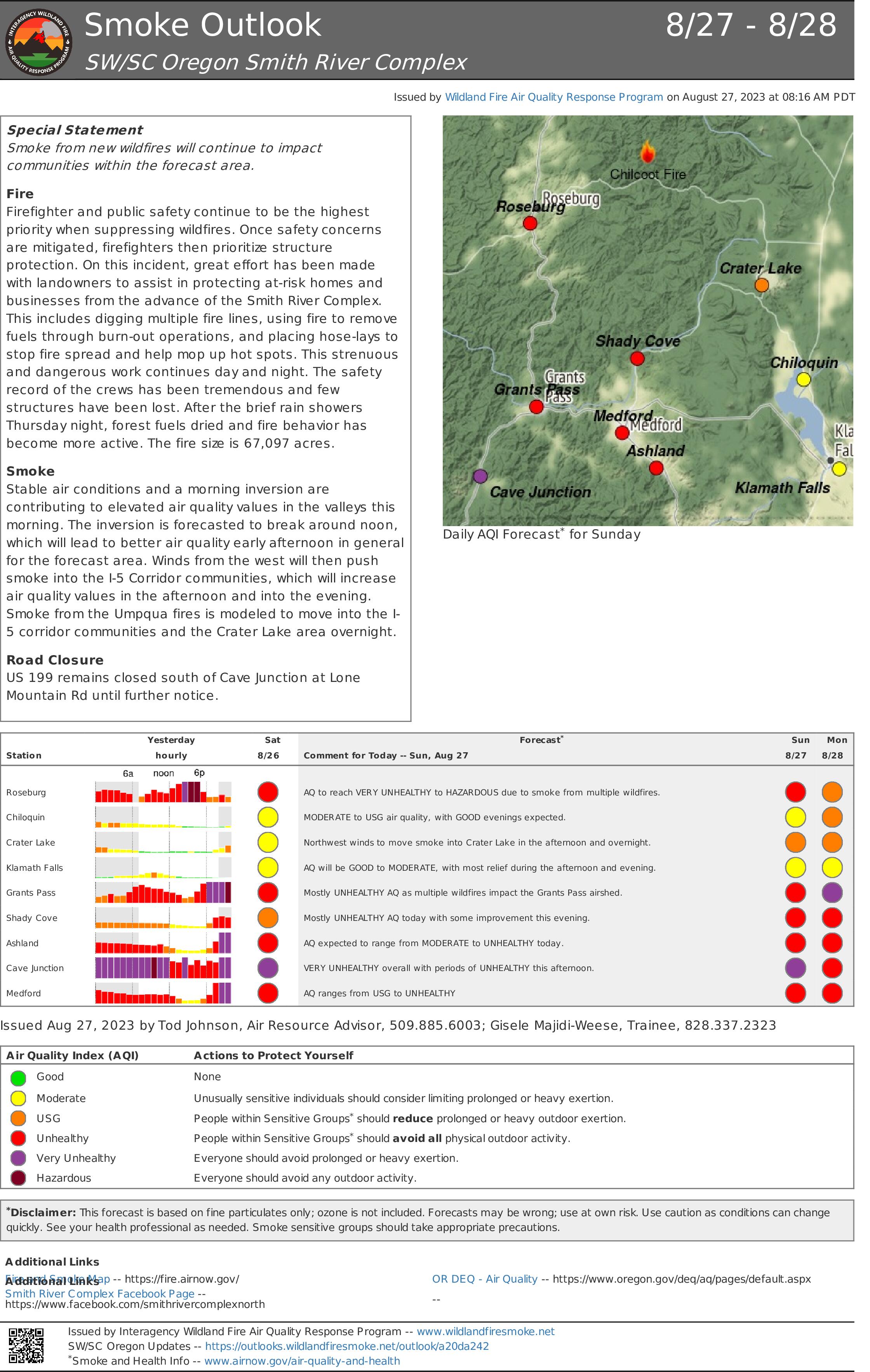
Smoke Outlook 827 828 Smith River Complex
Related Incident: Smith River Complex
Publication Type: News
Special Statement
Smoke from new wildfires will continue to impact communities within the forecast area.
Fire
Firefighter and public safety continue to be the highest priority when suppressing wildfires. Once safety concerns are mitigated, firefighters then prioritize structure protection. On this incident, great effort has been made with landowners to assist in protecting at-risk homes and businesses from the advance of the Smith River Complex. This includes digging multiple fire lines, using fire to remove fuels through burn-out operations, and placing hose-lays to stop fire spread and help mop up hot spots. This strenuous and dangerous work continues day and night. The safety record of the crews has been tremendous and few structures have been lost. After the brief rain showers Thursday night, forest fuels dried and fire behavior has become more active. The fire size is 67,097 acres.
Smoke
Stable air conditions and a morning inversion are contributing to elevated air quality values in the valleys this morning. The inversion is forecasted to break around noon, which will lead to better air quality early afternoon in general for the forecast area. Winds from the west will then push smoke into the I-5 Corridor communities, which will increase air quality values in the afternoon and into the evening. Smoke from the Umpqua fires is modeled to move into the I-5 corridor communities and the Crater Lake area overnight.
Road Closure
US 199 remains closed south of Cave Junction at Lone Mountain Rd until further notice.
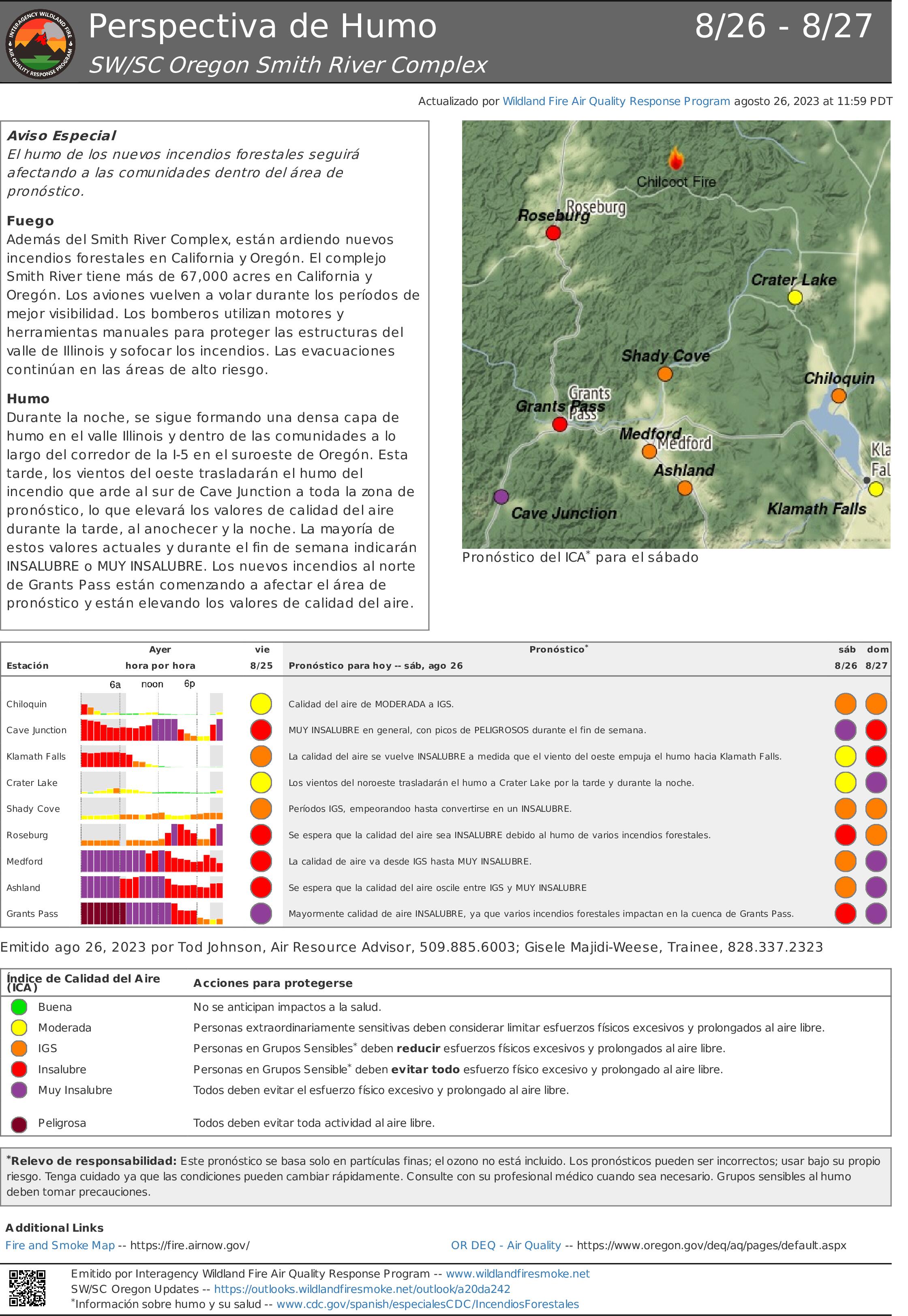
Perspectiva de Humo 826 827 Smith River Complex
Related Incident: Smith River Complex
Publication Type: News
Aviso Especial
El humo de los nuevos incendios forestales seguirá afectando a las comunidades dentro del área de pronóstico.
Fuego
Además del Smith River Complex, están ardiendo nuevos incendios forestales en California y Oregón. El complejo Smith River tiene más de 67,000 acres en California y Oregón. Los aviones vuelven a volar durante los períodos de mejor visibilidad. Los bomberos utilizan motores y herramientas manuales para proteger las estructuras del valle de Illinois y sofocar los incendios. Las evacuaciones continúan en las áreas de alto riesgo.
Humo
Durante la noche, se sigue formando una densa capa de humo en el valle Illinois y dentro de las comunidades a lo largo del corredor de la I-5 en el suroeste de Oregón. Esta tarde, los vientos del oeste trasladarán el humo del incendio que arde al sur de Cave Junction a toda la zona de pronóstico, lo que elevará los valores de calidad del aire durante la tarde, al anochecer y la noche. La mayoría de estos valores actuales y durante el fin de semana indicarán INSALUBRE o MUY INSALUBRE. Los nuevos incendios al norte de Grants Pass están comenzando a afectar el área de pronóstico y están elevando los valores de calidad del aire.
Valentine Fire Daily Update Sunday August 27 2023
Related Incident:
Publication Type: News
Valentine Fire completion reaches 14%
August 27, 2023 – Daily Update
Size: 14 acres
Start Date: August 16, 2023
Cause: Lightning
Completion: 14%
Total personnel: 242
Location: 11 miles northeast of Young, Arizona and 27 miles east of Payson, Arizona
Fuels: Hardwood litter and timber
Highlights: A community meeting will take place on Monday, August 28, at 7:00 PM at the Church of Jesus Christ of Latter-day Saints, 546 W. Ashby Apple Drive, Payson, AZ. Fire managers have updated their assessment of accomplishments on the incident, increasing to 14% completion of operational objectives. On the Valentine Fire, these objectives include confinement, point protection, and line preparation. Confinement involves restricting the fire to a defined area, primarily through use of natural barriers that are expected to restrict the spread of the wildfire under the prevailing and forecasted weather conditions. Point protection is a response strategy which protects specific assets or highly valued resources, and often involves using pumps, hoses, and sprinklers to protect structures and other identified values. Line preparation is the task of preparing an area by removing heavy concentrations of vegetation along roads and other holding features to prevent fire spread beyond the planned boundaries. Firefighters have been focusing the majority of their efforts on line preparation, completing approximately 90% of this work over the past several days. Collectively, these efforts align with the goals of the Forest Service Wildfire Crisis Strategy – to learn more, please visit: https://www.fs.usda.gov/managing-land/wildfire-crisis.
Operations: The Valentine Fire acreage remains the same after yesterday’s storm brought precipitation and higher humidity to the area. Although rain fell on the fire, it continues to burn slowly within the defined planning area. In some places, this slow burning fire is smoldering without a flame; in other areas, the fire is barely spreading or creeping with a low flame. With the increased moisture, smaller vegetation such as grasses, twigs, and leaves are not drying out until late in the day, resulting in a shorter burning period for the fire. Crews are continuing to prepare the perimeter of the planning area by improving conditions along National Forest System Roads 291 and 411, and constructing handlines to limit fire spread between these roads. Firefighters are staying alert to changing conditions to provide for safety, pausing work when thunderstorms presents a hazard over the fire.
Weather: Conditions will be partly cloudy with light downslope winds in the morning. Isolated showers and thunderstorms are expected to develop around noon. Expect brief moderate to heavy rainfall, small hail, and cloud-to-ground lightning. Overall winds will be light and terrain-driven at 10 MPH, with higher wind gusts up to 30 MPH with thunderstorm outflows.
Closures: The Tonto National Forest has issued an emergency area closure for the Valentine Fire. The purpose of the closure order is to protect public health and safety during the Valentine Fire, and to protect assigned firefighting personnel engaging in wildland firefighting operations. The full closure order (No. 03-12-05-23-22) and map are available on the Tonto National Forest website: https://www.fs.usda.gov/alerts/tonto/alerts-notices/?aid=82769.
Safety: The health and safety of firefighters and the public are always the first priority. Members of the public should stay away from Valentine Fire operations. A temporary flight restriction (TFR) is in place over the area, which includes unmanned aircraft, or drones. More information on the dangers drones pose to wildland firefighting aircraft and personnel on the ground can be found at: https://uas.nifc.gov/.
Smoke: Smoke from the Valentine Fire may be visible in the surrounding areas. Learn more about smoke impacts on the Arizona Department of Environmental Quality website at https://azdeq.gov/wildfire-faqs.
Fire updates are posted on InciWeb and the Tonto National Forest Facebook and Twitter
Email: 2023.valentine@firenet.gov
Phone: (928) 588-4033
Office Hours: 8:00 AM – 8:00 PM
Gray Fire Daily Update 90123
Related Incident: Gray Fire
Publication Type: News
Northeast Washington Team 3 will assume command of the Gray Fire from outgoing Northwest Team 7 on Saturday afternoon. A contingent of engines and firefighters will remain on the Gray Fire through the weekend to complete mop up and rehabilitation work. Continued cool, wet weather is assisting firefighters but they are still finding and extinguishing scattered pockets of heat and smoldering debris. Around 307 personnel are assigned to the incident as of Friday morning, but that number will continue to drop as resources are demobilized and assigned to other incidents.
Evacuations: On Wednesday afternoon, evacuation levels were dropped from a Level 2 to a Level 1 within the fire perimeter and were removed entirely outside the burned areas. Evacuation maps are posted on the Gray Fire Inciweb page and Spokane County’s Emergency Management Facebook page: https://www.facebook.com/GEGEmergencyMgt.
Yesterday’s activities: On Thursday, wildland fire crews continued work to clean up equipment and flagging left in place during the suppression effort, to rehabilitate dozer lines, mitigate any hazard trees, and extinguish isolated pockets of burning material. Thursday was the final night shift.
Today’s activities will be a continuation of mopping up and rehabilitating fire suppression impacts.
Weather and Fuels: Temperatures are expected to rebound back into the upper 70s on Friday and into the lower 80s on Saturday. Winds will be light from the northeast into Saturday morning then shifting to the southwest on Saturday afternoon. Fuel moisture levels have risen significantly which has minimized fire spread potential. Remaining pockets of interior heat with continued creeping and smoldering are possible. Fuels in dry areas, such as under tree canopies or matted grasses, will continue to smolder and may produce light smoke.
Disaster assistance: Resources are available through the Spokane County Disaster Assistance Center located at the Spokane Falls Community College, Building 9, 3305 W. Whistalks Way, Spokane, WA 99224 - phone: (509) 998-2750. Additional resources for property clean-up can be found at Spokane Regional Health and Spokane Air: bit.ly/44o05BX.
Prepare your property, Protect you neighbors. https://wildfireready.dnr.wa.gov/
Be wildfire aware! Avoid activities that can cause an accidental spark.
https://www.readyforwildfire.org/prevent-wildfire.
The Gray Fire is a No Drone Zone. Remember, if you fly, we can’t! https://www.faa.gov/uas/resources/community_engagement/no_drone_zone
Gray Fire Information and Links
Phone: 509-903-5563, 8:00 a.m. to 8:00 p.m.
Inciweb: https://inciweb.nwcg.gov/incident-information/wanes-gray-fire
Facebook: https://www.facebook.com/newfireinfo
Interactive Evacuation Map: https://arcg.is/1z98v10
WA DOT Highway Updates: https://wsdot.com/Travel/Real-time/Map/
Washington Smoke Blog: https://wasmoke.blogspot.com/
Spokane Co. Emergency Management: 1121 W. Gardner Ave., Spokane; 509-477-3046
https://www.spokanecounty.org/4579/Emergency-Management
Red Cross: 315 W. Nora Ave., Spokane; 509-326-3330
https://www.redcross.org/local/washington/get-help.html
Avista Power & Gas: 1411 E. Mission Ave, Spokane; 800-227-9187
https://www.myavista.com/outages/outage-faqs
Inland Power: 10110 W. Hallett Rd, Spokane: 509-747-7151
https://www.inlandpower.com/outages-emergencies
City of Medical Lake Public Utilities: 851 S. Lefevre St, 509-299-7715
https://medical-lake.org/utilities/
WA Dept. of Social and Health Services: 877-501-2233
https://www.dshs.wa.gov/esa/community-services-offices/community-services-office
Spokane County Sheriff: 1100 W. Mallon Ave, Spokane; 509-477-2240
https://www.spokanecounty.org/938/Sheriff-Services
Spokane County Fire, Dist. 3: 10 S. Presley Dr, Spokane; 509-235-6645