
Bedrock Daily Update August 27 2023
Related Incident: Bedrock Fire
Publication Type: News
Bedrock Fire Quick Facts
Size: 31,579 acres Origin: Willamette National Forest Resources: 39 engines;
Containment: 57% Cause: Under Investigation 13 crews; 11 helicopters;
Total personnel: 734 Start Date: July 22, 2023 8 dozers, 30 water tenders
Firefighters, aircrews and helicopters, and heavy equipment from the Bedrock Fire will be heavily engaged with new fires in the area today, including the Horse Creek and Pothole incidents. Other personnel are being shifted to the more active Lookout Fire. At the same time, hundreds of personnel are still working to finalize containment on the Bedrock Fire. Pacific Northwest Team 2 (PNW2) is now managing all four fires. “While our main focus has to shift to Lookout and the two new fires, we know we also have to finish the job on Bedrock,” said Jason Loomis, PNW2 Incident Commander. Because of the progress that has been made, firefighters will begin removing structure protection equipment currently in place in the Big Fall Creek community. Last night was also the final night shift on the Bedrock Fire and those firefighters are being moved to the Lookout Fire. All containment lines have been holding and firefighters continue to patrol the perimeter, taking any actions necessary to keep the perimeter secure.
Evacuations: PNW2 is working with the Lane County Sheriff to adjust evacuation levels, as necessary, to address changing conditions for both the new, and the older, fires in this area. An up-to-date and searchable evacuation map is available through the county’s website: Bedrock Fire Evacuation Areas (https://bit.ly/44rF8Gd). Residents can also call the county at 541-682-2055 for additional information.
Smoke: A changing weather pattern is expected to help push smoke out of the area starting tomorrow. The daily West-Central Oregon Smoke Outlook provides a detailed air quality forecast for the Bedrock Fire, as well as other nearby fires. The Fire and Smoke Map (fire.airnow.gov) is another source for air quality information.
Weather: Hot and dry again today with a temperature inversion trapping smoke in the area until afternoon. Smoke should clear after the inversion breaks and the winds shift to blowing out of the west and southwest.
Safety and Closures: The Willamette National Forest has implemented emergency closures to ensure the safety of the public and personnel working on multiple fires in this area. The closure maps for the Bedrock and Lookout Fires are available on InciWeb and the “alerts and notices” page of the Willamette National Forest website. Temporary Flight Restrictions remain in place over the Bedrock and Lookout fire areas.
InciWeb Bedrock: https://inciweb.wildfire.gov/incident-information/orwif-bedrock-fire
Facebook: https://www.facebook.com/BedrockFire2023/
Fire Information: (541) 414-6272, 8:00 AM – 8:00 PM Email: 2023.bedrock@firenet.gov
Smith River Complex North update August 27 2023
Related Incident: Smith River Complex
Publication Type: News
Smith River Complex North update for Sunday, August 27, 2023
GRANTS PASS, Ore. – Activity on the Kelly Fire increased Saturday afternoon. Wind gusts of up to 18 mph and ongoing warm, extremely dry conditions drove fire spread.
A new spot fire established just west of Gilligan Butte but did not breach the primary containment line protecting the Illinois Valley near O’Brien. Protecting structures in this area and keeping the fire from crossing the primary containment line is a top priority for fire personnel. Fire resources are working day and night shifts, and three additional Hot Shot crews have arrived to engage in this effort.
Fire personnel also continue to construct direct and indirect fire lines from the Rough and Ready Creek drainage area northeast of the fire, south and west of Gilligan Butte along the 4402 Road to Hwy 199. They are also constructing lines southeast of Hwy 199 in the Elk Creek area south of the California Border, following the 18N11 Road to the 444 Road.
The weather forecast through Tuesday calls for a similar pattern of morning fog and persistent heavy smoke. This will result in poor air quality, low visibility, and limited air operations.
A Level 3 – GO NOW evacuation remains in place for the Hwy 199 area south of O’Brien from mile post 38 into California. A Level 2 – GET SET evacuation is in place for O’Brien and the Takilma area. A Level 1 – GET READY evacuation is in place heading north to Cave Junction. The American Red Cross has set up an evacuation shelter at Rogue Community College in Grants Pass. Livestock can be sheltered at the Josephine County Fairgrounds.
Due to increased fire activity, the public is encouraged to monitor the Rogue Valley Emergency Management site at https://rvem.org for updates and sign up for Citizen Alert if you have not already done so. The interactive Fire First Response Map showing evacuation areas can also be found there.
The Rogue River-Siskiyou National Forest has implemented an area and road closure order for the Smith River Complex. Visit the forest website for additional information at https://tinyurl.com/2s4hymku. The Bureau of Land Management Coos Bay District announced an emergency closure of public lands south of Waldo Road and Happy Camp Road to the Oregon/California border. Additional information can be found at https://www.blm.gov/orwafire.
A community meeting will be held at 6 p.m. Monday, August 28, at Illinois Valley High School, 625 E. River St., Cave Junction. The meeting will also be live-streamed on the Smith River Complex North 2023 Facebook page.
Black Feather Fire Information Update 08272023
Related Incident: Black Feather Fire
Publication Type: News
Sunday, August 27, 2023
Forward movement on The Black Feather Fire
Acres: 2,198 acres
Start Date: August 5, 2023
Cause: Lightning
Fuels: Timber, Brush, Understory
Containment: 28%
Resources: 119 personnel
Highlights: Hand crews and repellers worked along the wilderness boundary and progressed line construction. Heavy equipment continued to improve road conditions, use caution while traveling in this area. The Black Feather fire received significant rainfall yesterday aiding the crews in suppressing the fire.
Hand crews gained more progress in the wilderness in continuing and securing the fires edge. Engine crews outside of the wilderness have been patrolling and monitoring the fires edge along with securing any hotspots or smoke showing within the fire's perimeter.
Operations: Suppression efforts are continuing within the wilderness and along the fires edge. As most of the fire is located in the wilderness, firefighters are working in steep terrain with heavy dead and down logs and fire weakened trees. Crews and engines are actively suppressing and monitoring activities in relation to weather and fire behavior to ensure incident objectives are met while remaining focused on firefighter safety.
Safety: Equipment and fire crews are actively moving in and around the fire area. Please use caution when traveling around the Black Feather Fire. The Temporary Flight Restriction is still in place. Please do not fly drones anywhere near the fire. If you fly, we can’t fly.
Weather: Showers and thunderstorms remain possible on Sunday, with storms developing they will move towards the East or Southeast around five to ten miles per hour. Ventilation will remain poor through Sunday. Scattered showers and thunderstorms are expected through the afternoon and evening.
Restrictions/Closures: Effective Monday, August 21, the Santa Fe National Forest has issued an updated area, road, and trail closure in part of the Coyote Ranger District. See https://bit.ly/BlackFeatherClosureUpdate for information and a corresponding map. Forest Road 103 is now open. Closures will be adjusted based on fire activity.
Smoke: Variations in temperatures, humidity & fire activity will impact smoke conditions in the coming days and weeks. Smoke may be visible in the area as active smoldering takes place. Smoke-sensitive individuals and people with respiratory problems or heart disease are encouraged to take precautionary measures. Air quality information is available at https://www.airnow.gov/.
Evacuations: The communities of Mesa Pinabetal, Mesa Poleo, and Wetherill remain in ‘Ready’ status. The Coyote Senior Center is open to evacuees, and livestock can be taken to the Rio Arriba Rural Event Center near Abiquiu. The Rio Arriba County Sheriff’s Office will coordinate evacuations if they go into effect. For more information, use the QR code below and visit the Sheriff’s Office Facebook page: https://www.facebook.com/profile.php?id=100079688263048.
27 de Agosto 2023 Informacin al da para el Incendio Flat
Related Incident: Flat Fire
Publication Type: News
Extensión: 34,242 acres
Origen: 2 millas Sureste de Agness, OR
Contencion: 58%
Fecha de Inicio: 15-Julio-2023
Personal: 415
Recursos: 11 escuadrillas de bomberos l 3 helicópteros l 17 camiones de bomberos l 3 buldóceres l 16 cisternas l 4 máquinas masticadoras
Resumen: Las condiciones favorables del tiempo para los próximos días, ayudaran a limitar la actividad del incendio. Asimismo, los bomberos podrán continuar progresando hasta alcanzar completamente sus objetivos en los esfuerzos de supresión. El grupo para Ataques Iniciales (IA) continúa apoyando tierras forestales en tres Incendios tales como Cedar, Anvil y Barklow, los cuales se localizan al Norte y al Noroeste del Incendio Flat.
Actividades para el día de hoy: Nuevamente los bomberos se encuentran enfocando sus esfuerzos cerca del lado Norte y Noreste del incendio, realizando trabajo de reparación de supresión a lo largo de senderos, dentro de alcantarillas y en otras áreas de importancia significativa. En la misma zona, los recursos han empezado operaciones de astillado como parte de los esfuerzos generales de supresión. Sobre el flanco Este, en donde las condiciones del terreno son extremadamente difíciles, las aeronaves continúan volando diariamente para proveer información y observar cualquier calor persistente o la presencia de humo. Fueron detectadas ciertas zonas con emanación de calor entre el interior del incendio a través de un vuelo Infrarrojo (IR) que se fue realizado durante la noche. Esto no representa ningún peligro para las líneas de contención o cualquier característica avanzada de control. Sobre los lados Sur y Oeste del incendio, los recursos se encuentran patrullando líneas para asegurar la estabilidad de estas y chequear cualquier humo proveniente de su interior. Se prosigue con los trabajos de reparación de supresión, así como también regresando al campamento cualquier exceso de equipo y suministros en el área.
Condiciones climáticas: Prevalecen temperaturas medias junto con humedad relativa más alta. Un frente seco y frio brindara temperaturas ligeramente frescas el lunes y martes en conjunto con una incrementación ligera de vientos provenientes del Noroeste.
Condiciones de humo: La prolongación del humo dentro del área está desplazándose hacia el Norte extendiéndose desde el Incendio Smith River Complex y asentándose en las comunidades cercanas como Brookings. Información acerca de las perspectivas de Humo se encuentran disponibles en:
https://outlooks.airfire.org/outlook/en/a20da242
Ordenes de Cierres: El U.S. Highway 199 ha sido cerrado al Norte de Gasquet debido a incendios en el Bosque Nacional de Six Rivers, por favor use la ruta U.S. Route 101 hacia SR 42s para viajar hacia y desde Rogue Valley. Las carreteras del Servicio Forestal y BLM no deberán ser utilizadas como rutas alternativas debido a la actividad de surgimiento de incendios en la zona. El Bosque Nacional de Rogue River-Siskiyou ha declarado una orden de cierre incluyendo senderos, caminos y una porción del área de Illinois River. Información acerca los cierres en el área del Incendio pueden encontrarse en: Rogue River-Siskiyou National Forest - Alerts & Notices (usda.gov)
Evacuaciones: Todos los niveles de evacuación han sido reducidos a un Nivel 1 “Prepárese” para todas las áreas en las proximidades del Incendio Flat. Para más información: Welcome to Curry County, OR
Orden de restricción: Actualmente, el Nivel de Peligro de Incendio es “Extremo”. El Bosque Nacional de Rogue River-Siskiyou implemento un Nivel 3 en las Restricciones para el Uso Público (PURs). Asimismo, se encuentra en pie un Nivel 3 (PURs) para la Sección Nacional Virgen de Rogue que fue implementada por el Bosque Nacional de Rogue River-Siskiyou, BLM en Medford y ODF. Para mayor información visite:
Rogue River-Siskiyou National Forest - News & Events (usda.gov)
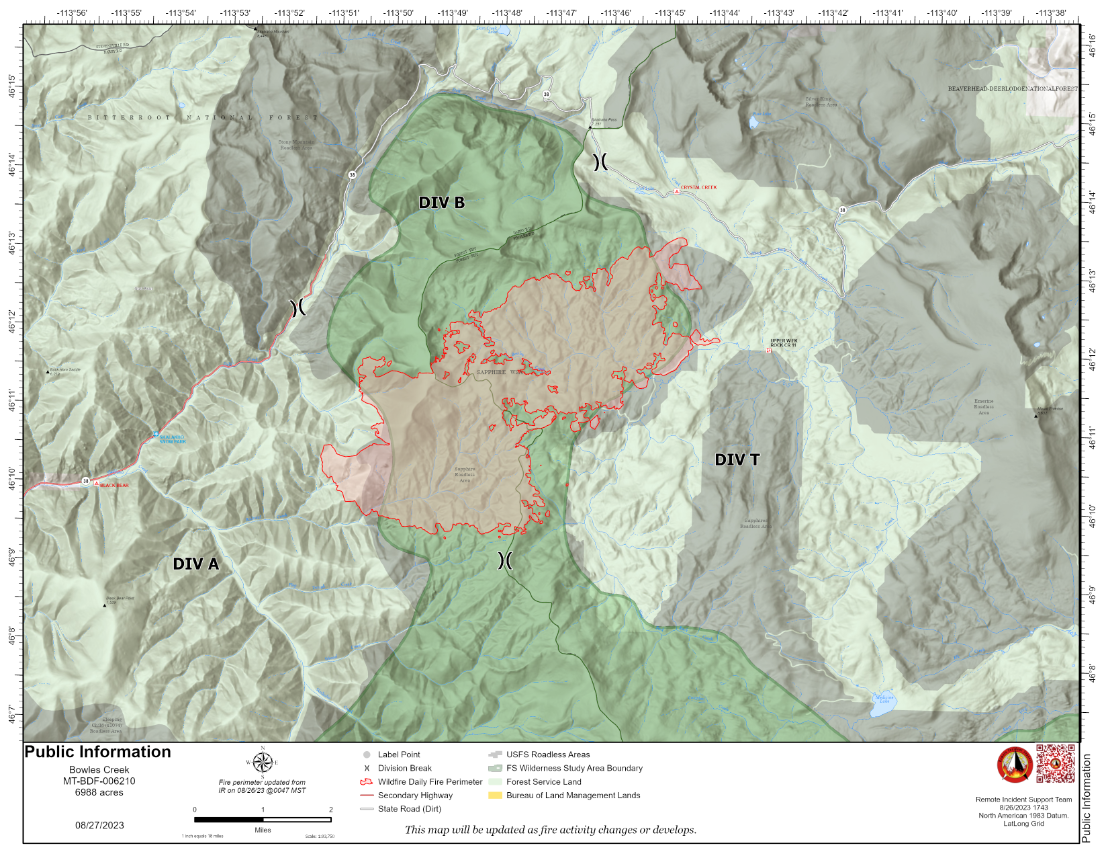
Bowles Creek Update August 27 2023
Related Incident: Bowles Creek Fire
Publication Type: News
The Bowles Creek Fire is currently at 6,988 acres. Fire crews remain present along Hwy 38, Skalkaho Road. With increased weekend traffic, motorists should yield and be cautious of firefighters who are present along the roadway. Additionally, motorists should be aware of debris on the road, as increased wind events and precipitation has increased the potential for falling trees.
Completion of fire management objectives remains at 23%. Fire personnel continue to work on confinement and point zone protection to protect values at risk. Structure protection assessments are completed; however, fire personnel are present to mitigate any future fire risk. Firefighters continue to construct fuel breaks and monitor fire behavior and improve fireline as needed.
2023 Six Rivers National Forest Lightning Complex and Redwood Lightning Complex Update 82723
Related Incident: 2023 SRF Lightning Complex and Redwood Lightning Complex
Publication Type: News
2023 Six Rivers National Forest Lightning Complex and Redwood Lightning Complex August 27, 2023 – California Incident Management Team 2 is in command of the Six Rivers National Forest (SRF) 2023 Lightning Complex and Redwood Lightning Complex, which is now comprised of 18 fires. CIIMT2 has taken command of the Marlow Fire from the Smith River Complex due to its proximity to the Blue Creek 2. Total acreage is estimated at 9055.7 acres (excluding Marlow) with containment at 15%.
Redwood National and State Parks Area
Lost – 5% contained. 722 acres. Crews continue full suppression tactics on the fire that is burning in the Lost Man watershed. CAL FIRE and Green Diamond Resource Company are collaborating in suppression efforts. A majority of the fire is in previously logged, second growth forest. Crews have held the fire on Holter Ridge. A small portion of the fire has slowly spread downslope into old growth redwood forest, where higher humidity has reduced fire activity.
Bridge Ridge – This is a 12 acre fire burning near the Devil Fire with poor accessibility. Crews expect to have the fire contained by the end of the day.
Devil – 100% contained. 12.4 acres. In patrol status.
Glen – 100% contained. .1 acre. In patrol status.
Hoopa Area
Lone Pine – 60% contained. Located south of Hoopa in the Horse Linto Creek watershed east of the Trinity River and across the river from Tish Tang Campground and Sugar Bowl Ranch, fire size is estimated at 1,683 acres. The fire is smoldering with isolated areas of heat and minimal growth. The line has been mopped up 100-150’ deep. The advisory status in Hoopa Valley Evacuation Zone HIA E-014B has been removed. Orleans Area
Pearch - East of Orleans is estimated at 2,046 acres. Crews are preparing to complete a burning operation to assist in containment to prevent the fire from a westerly spread towards Orleans. Structure protection personnel are continuing structure protection activities throughout the area. Hose line and sprinklers have been deployed around values at risk. Firing operations are expected to begin today along the southeast edge of the fire.
Creek – .1 acre and is in patrol status. Flat – .1 acre and is in patrol status.
Merrill Mountain – 1.8 acres near the 12N08 Road. It is anticipated this fire will be in patrol status by the end of today.
Monument – .1 acre. This fire is unstaffed due to difficult terrain and firefighter safety.
Pearch Fire Evacuation Warning:
Orleans Area: Zone HUM-E009 (Southeast of the Klamath River in Orleans) Zone HUM-E008-B (Community of Orleans, west of Klamath River. East of Crawford Creek, including Orleans proper). Hwy 96 and Red Cap Road along the east bank of Klamath River, south from Salmon River, east to Orleans Mountain. Approximately 243 residents live in these 2 zones. Somes Bar Area: Zone SIS-1701: NORTH of Monte Creek Road, SOUTH OF Camp Three Road, EAST OF Camp Three Road, WEST OF Wooley Creek Trailhead. Anyone in these areas should be prepared for potential evacuations, including personal supplies and overnight accommodations. Be ready to go at a moment's notice.
Iron – 19.9 acres and is in patrol status.
Hancock – 218 acres. Located in the Wooley Creek area within the Marble Mountain Wilderness. The smoke jumpers that were in place were extracted because of the dangerous weather conditions. The fire has a slow rate of spread but is in difficult terrain preventing direct firefighting. Prior to extraction, personnel engaged in point protection activities to protect values at risk in Wooley Creek.
Mosquito - Near the Bluff Creek area north of Mosquito Lake is estimated at 1,903 acres. The fire remains north of Forest Road 11N19 and west of Forest Road 12N12 (Cedar Camp Road). Containment lines along the 12N12 Road have held. Crews continue constructing containment lines.
Bluff #1 – 1,419 acres with minimal movement. Firing operations have been utilized to assist with line construction along the 11N16 Road.
Blue Creek - .1-acre and is in patrol status.
Blue Creek 2 - 976 acres.
The Blue Creek 2 - is currently unstaffed due to difficult terrain and for Firefighter safety.
Marlow – 999 acres. Burning northwest of Blue Creek 2. Assumed from the Smith River Complex.
Let er-Buck - 42 acres. A falling team has been inserted to clear an area to allow access for Firefighters.
Weather – Today’s weather will be similar to yesterday with low-level stratus below 1500-2000 feet. Cloud cover is expected to burn off in the early afternoon except for along the coast. Six Rivers National Forest Closures Area and campground closures are in effect on Six Rivers National Forest.
A new Closure Order was issued for the Orleans Ranger District and a portion of the Lower Trinity Ranger District. They can be found at: https://www.fs.usda.gov/detail/srnf/notices/?cid=FSEPRD1096395.
Redwood National Park and State Parks Closures There are multiple closures in the parks due to several fires, including closures in the Lost Man area. For a full list of closures and impacts, please visit www.nps.gov/redw/planyourvisit/conditions.htm
Visit this link to access all resources listed on this update: www.linktr.ee/srffirepio Alert Notifications ZoneHaven/Genasys for map and zone identification: https://protect.genasys.com
Humboldt County Residents Register for Humboldt Alert Notification: www.humboldt.gov/alerts
Siskiyou County Resident Register at Code Red Alert Notification: https://public.coderedweb.com/CNE/en-US/6F327CCDFFFD
Redwood National and State Parks Information Hotline
Phone: 707-464-6101 https://www.nps.gov/redw/planyourvisit/conditions.htm
2023 SRF Lightning Complex Fire Information Phone: 530-536-0767
Email: 2023.lightningcomplex@firenet.gov
Hoopa Information Hotline
Phone: 530-618-2995
Email: serene.oes@gmail.com
Flat Fire Morning Update 08272023
Related Incident: Flat Fire
Publication Type: News
Size: 34,242 acres
Start Date: July 15, 2023
Point of origin: 2 miles southeast of Agness, OR
Containment: 58%
Total personnel: 415
Resources: 11 crews l 3 helicopters l 17 engines l 3 bulldozers l 16 water tenders l 4 masticators
Highlights: More favorable weather conditions over the next few days should help limit fire activity, allowing crews to productively continue toward full suppression efforts. An Initial Attack (IA) group continues to support the forest with three fires, Cedar, Anvil, and Barklow Fires, which are burning north and northwest of the Flat Fire.
Today’s Activities: Crews focused efforts again near the north and northeast sides of the fire, conducting suppression repair work along trails, within culverts and other significant areas of importance. Resources also started chipping operations there as part of overall suppression efforts. On the eastern flank, and due to extreme terrain, aircraft continues to fly daily, providing intel and observing for any lingering heat or smokes. An overnight Infrared (IR) flight picked up some heat signatures well within the interior of the fire. But that remaining heat is not a threat to the containment line or any control features. On the south and west sides of the fire, resources are patrolling line to ensure line stability and checking for any interior smokes. Suppression repair work to dozer line continues along with the backhauling of any excess equipment and supplies back to camp.
Weather: Mild temperatures prevail again along with higher humidity. A dry cold front will bring slightly cooler temperatures Monday and Tuesday along with a slight increase in northwest winds.
Smoke: Smoke lingering within the area is moving north from the Smith River Complex and settling within some nearby communities, like Brookings. The smoke outlook for the Smith River Complex is available at: https://outlooks.airfire.org/outlook/en/a20da242
Closures: U.S. Highway 199 has been closed north of Gasquet due to fires on the Six River National Forest, please use U.S. Route 101 to SR 42 for all travel to and from the Rogue Valley. Forest Service and BLM roads should not be used as alternate routes due to emerging fire activity. The Rogue River-Siskiyou National Forest (RRSNF) has issued a closure order for the fire area including trails, roads, and a portion of the Illinois River. Visit Rogue River-Siskiyou National Forest - Alerts & Notices (usda.gov) for more information.
Evacuations: Level 1 “Get Ready” evacuation status in place for areas in the vicinity of the Flat Fire. Link to more information: Welcome to Curry County, OR
Restrictions: Fire danger is currently extreme; the RRSNF is implementing Level 3 Public Use Restrictions (PUR). Level 3 PURs on the Wild Section of the Rogue River have been implemented by the RRSF, Medford BLM and ODF. More information: Rogue River-Siskiyou National Forest - News & Events (usda.gov)
Big Knife Update August 27 2023
Related Incident: Big Knife
Publication Type: News
As the warming and drying trend persists, fuels will dry out, and fire will continue to creep and smolder. Overnight humidity recoveries in the 80-90% ranges are helping to minimize smoke impacts.
The final piece of handline from S Canal Rd to the fire’s edge was completed yesterday and personnel will be back today to improve the holding feature. All pumps and hose-lays along the S Canal Rd have been removed and crews continue their suppression repair efforts.
An estimated 15.6 miles of line, including both hand line and dozer line, is identified for suppression repair work. Line repair involves pulling soil and organic material back into the line and re-contouring if needed. Brush and logs are placed on top to blend the line in with its surroundings, limit erosion, and discourage off-road use. Water bars will be installed in areas to divert the flow of water off a line to minimize erosion. Excavators repair dozer lines while hand crews restore the hand lines.
The Big Knife Fire is currently 1.25 miles north of the Rattlesnake Wilderness Boundary (Lolo National Forest) with no significant growth towards the Lolo National Forest in the last week. Smoke from the fire may impact the Snowbowl area, however the Lolo National Forest does not have any forest closures in place on the Missoula Ranger District.
CLOSURES AND SPECIAL MESSAGES: Several areas near the base of the mountains west of the Big Knife Fire remain in PRE-EVACUATION WARNING by order of the Lake County Sheriff. See the map for those locations in yellow (Jocko, Canal, Francis). The Tribal Primitive Area, Belmore Slough and Burnt Cabin Roads are closed.
A PRE-EVACUATION WARNING means you may remain in your home. Individuals in this status should not bring back evacuated livestock until this status is lifted.
A temporary flight restriction (TFR) is in effect around the fire area. Do not fly unmanned aircraft (drones) near the fire areas.
Weather: Another hot and dry day is expected today, with temperatures creeping into the mid to high 80s with relative humidities in the high teens and 20s.
FIRE RESTRICTIONS: Stage 1 fire restrictions are currently in place across the Flathead Indian Reservation and Lake County. Stage 1 fire restrictions remain in place in Granite County. In Stage 1 fire restrictions the following are prohibited until rescinded: Building, maintaining, attending, or using a fire or campfire except within a developed recreation site or improved site. Smoking, except within an enclosed vehicle or building, a developed recreation site or while stopped in an area at least three feet in diameter that is barren or cleared of all flammable materials. On the Flathead Reservation, operating a motorized vehicles off designated roads and trails. Visit https://www.mtfireinfo.org/ for more fire restriction information across Montana.
East Fork Fire August 27 2023 Update
Related Incident: East Fork Fire
Publication Type: News
NORTHERN ROCKIES TEAM 6
INCIDENT COMMANDER: Paul Roose
East Fork Fire
Kootenai National Forest/Flathead National Forest
Fire Information 406-285-8634, Eastforkfireinfo@gmail.com
August 27, 2023
Location: 12 miles south of Trego, MT
Start Date: 7/30/2023
Cause: Lightning
Size: 5,106 acres
Containment: 15%
Total Personnel: 614
Engines: 16
Hand Crews: 12
Helicopters: 2
Yesterday’s Events: The mosaic pattern of the burn is due to the steep terrain and dense, old growth forest punctuated by newer growth in plantations. This combination of factors meant that firefighters resorted to various tactics and tools to build containment lines. Heavy equipment such as skidgens, feller bunchers and dozers made rough fire lines in accessible areas. These areas were cleaned of felled vegetation to more reliably contain an advancing fire. Hot Shot and hand crews cut trees, dug handlines and laid miles of hose in harder to reach areas. Helicopters dropped water on hot spots to cool them in support of ground forces. Teams successfully used low intensity fire in back burns on the north side of the fire to remove fuels from areas between the established fireline and the fire itself.
Plans for Today: Firefighters will continue with the successful operations utilized over the last several days. Helicopters will continue with targeted bucket drops. In addition, firefighters will use low intensity burning to strengthen the fireline on the south side of the fire. For the next 4 to 5 days, night operations will remove brush and trees from the mechanically created breaks. Crews will continue current operations to scout and build contingency lines to the east and northeast to further protect the Hwy 93 corridor, homes and the Labeau Research Natural Area.
Weather Update: This week the weather is predicted to be hot and dry with little wind until Tuesday afternoon. A frontal system is expected to move in over the region and the windy conditions will test the fire lines. Rain and colder temperatures will follow this front providing another season slowing opportunity.
Evacuations: Some communities remain in a Pre-Evacuation Warning. Residents may return to their homes under a Pre-Evacuation Warning, but may need to leave again on short notice. For more information, go to the Lincoln County and Flathead County Sheriff’s Department Facebook pages.
Public Meetings: No public meetings are scheduled at this time, though fire personnel are available to address questions or concerns via the email address and telephone number noted above.
Deep Fire Update August 27 2023
Related Incident: Deep Fire
Publication Type: News
CURRENT SITUATION
The Deep Fire was mapped overnight at 3,838 and remains 58% contained. Good work continued yesterday. Several areas continue to hold heat, specifically in the northeast and southeast corners of the fire, but there the fire has remained within proposed containment lines.
On the southern end of the fire, crews adapted their traffic pattern to avoid the Trinity Alps Resort as it reopened for business yesterday. Residents and visitors are advised that despite good containment progress, there is still heat remaining inside the fire footprint and fire-weakened snags could pose a considerable threat. A Forest Closure remains in effect in the area for public and firefighter safety, and smoke is likely to be visible for the foreseeable future.
On the southern and southeastern edge of the fire, crews worked primarily directly along the fire’s active edge, mopping up, extinguishing hot spots, and making sure no burning material is close enough to the line to pose any threat to containment. They were able to complete line to Sunday Creek, effectively containing the fire’s southeastern edge. They will continue to improve that line today.
Up the Stuart Fork Trial, multiple resources remain in place, ensuring that mitigation measures are in place as smoldering material continues to roll off the steep slopes above the trail.
The fire continues to back into the Little Salt Creek drainage on the north end of the fire. Activity was observed there yesterday as fuels warmed and dried. Crews utilized helicopters to cool the edge as a small finger of fire moving through continuous fuels flanked across the slope. Fuels in the area are sparse, and the fire remains positioned to run into rock.
WEATHER
The warming and drying trend of the last few days will continue through today, bringing light diurnal winds. A change is anticipated Monday and Tuesday as an upper level trough moves through the fire area, bringing the potential for westerly winds and slightly cooler temperatures.
ROAD CLOSURES
There are currently no road closures associated with the Deep Fire. For information on roads in the area, visit https://dot.ca.gov/
FOREST CLOSURES
There is a forest closure associated with the Deep Fire. For current information on forest closures, visit https://www.fs.usda.gov/stnf
EVACUATION UPDATES
For the latest evacuation information from the Trinity County Sheriff’s Department: https://www.facebook.com/people/Trinity-County-Sheriffs-Office/100064589806351/
For information on evacuation resources from the Trinity County Office of Emergency Services: https://www.trinitycounty.org/OES
To sign up for codeRED notifications: text “TrinityCA” to 99411.