
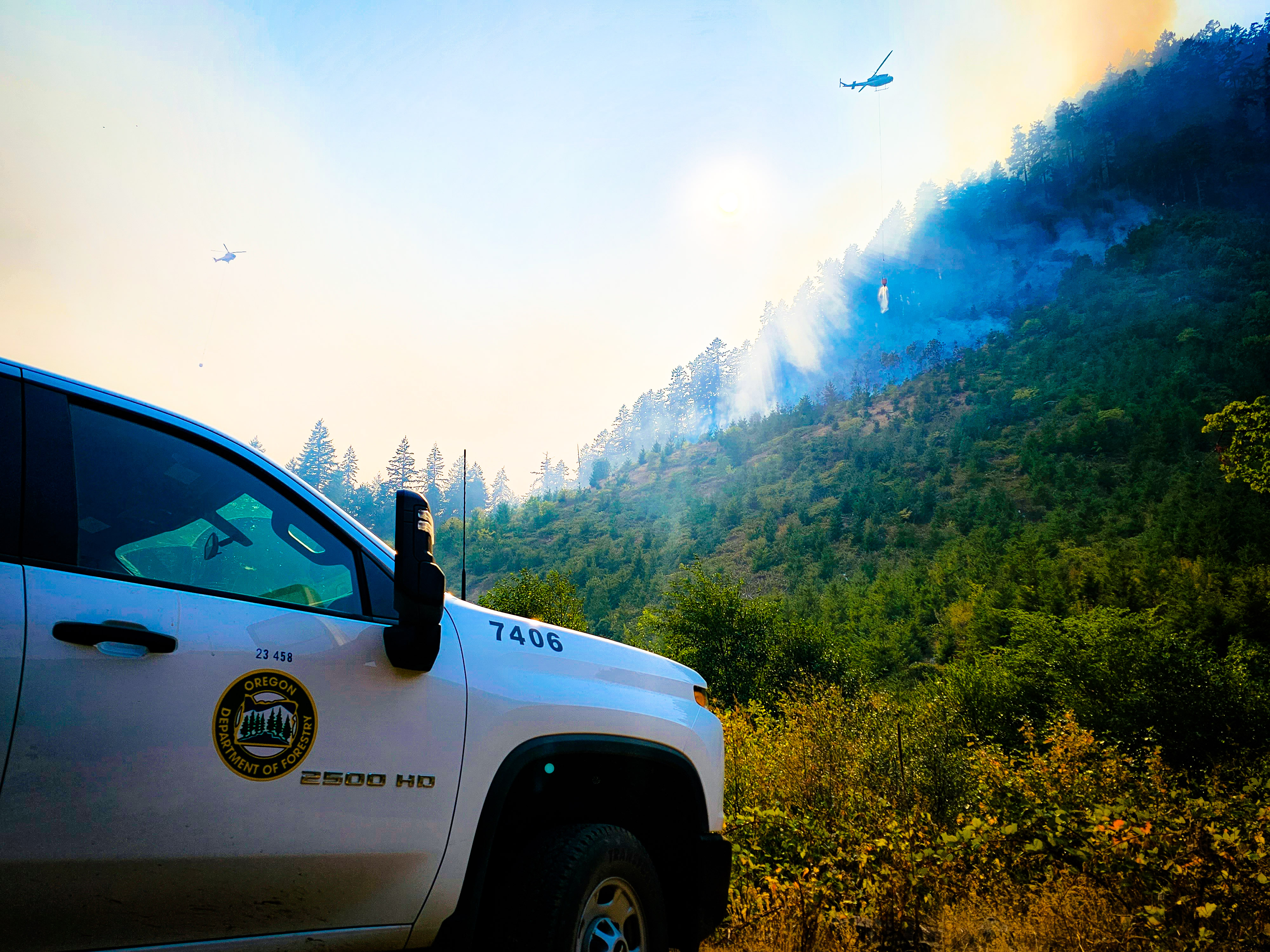
Tyee Ridge Complex Morning Update 082823
Related Incident: Tyee Ridge Complex
Publication Type: Announcement
Acreage: 2,897
Containment: 5%
Progress Continues on Tyee Ridge Complex
Umpqua, OR – Overnight, crews made good progress building hand and dozer line on the Tyee Mountain, Hardscrabble, and Big Tom Fires. Strategic backfiring helped reinforce these lines and create additional safety zones for firefighters. Lines held successfully on the Yellow Point and Blue Hole Fires. On the Cougar Creek Fire, crews established a handline and hose lay from Hubbard Creek up to the bluffs. Efforts were aided by slightly cooler temperatures and higher relative humidities. With steep terrain, rolling material and falling snags continue to be a challenge and caused slopovers of fire across lines on the Hardscrabble and Cougar Creek Fires.
More firefighters and equipment are arriving today from around the nation, including hotshot crews and heavy equipment. A total of seven Oregon State Fire Marshal taskforces continue to engage in structure protection. Day shift operations will continue to build on last night’s progress. This will include dozer line on Big Tom, Hardscrabble, and Cougar Creek. This will allow further strategic backfiring over the next few operational periods. Twelve helicopters are in use and will be dropping water on the fires when smoke conditions permit.
Weather is expected to be in the mid 70s today with areas of smoke. Where smoke is present, it will help moderate fire behavior. Winds will be 2 to 5 miles per hour from the NW. Relative humidities recovered well overnight but fuels still will burn actively during the day, especially where the smoke lifts.
All evacuation notices issued by the Douglas County Sheriff's Office remain unchanged. The Red Cross shelter for evacuees at the Oakland Elementary School will be relocating today and the new location will be posted to the Tyee Ridge Complex and Douglas County Sheriff Facebook pages as soon as it is available. To shelter livestock, contact Douglas County Fairgrounds at 541-957-7010. Companion pets can be sheltered at Saving Grace Pet Adoption Center in Roseburg. To view the current evacuation information map, go to www.dcso.com/evacuations.
Community Meeting Scheduled: The Tyee Ridge Complex management teams will be holding a community meeting tonight, Monday, Aug. 28, 2023 at 7 pm.
Location: Roseburg Country Club, 5051 Garden Valley Road, Roseburg; and streamed on Facebook Live and YouTube.
Evacuations: Level 3 (Go Now!) from the 11000 block of Hubbard Creek Rd. to Millwood Dr. Level 2 (Be Set) from Hubbard Creek Rd. from the Millwood Dr. intersection to Melqua Rd. Level 1 (Be Ready) for Tyee Road at the intersection with Rock Creek Road to Fanchin Lane.
Closures: Hubbard Creek Road at Millwood Drive. Please avoid this area.
LookoutHorse CreekPothole Fires Daily Update 8282023
Related Incident: Lookout Fire
Publication Type: News
August 28, 2023
Morning Update
Size: 22,317 acres
Start Date: August 5, 2023
Cause: Lightning
Containment: 17%
Point of origin: 3 miles North of McKenzie Bridge, OR
Total personnel: 986
Resources: 55 engines l 16 crews l 15 bulldozers l 28 water tenders l 12 masticators l 9 helicopters
Lookout Fire
Cooler temperatures and higher humidity helped moderate fire behavior allowing firefighters to make good progress Sunday. Primary and alternate control lines are being prepared across the northern, western and eastern flanks of the fire to stop further growth beyond those lines. Helicopters were mostly grounded due to smoke but, as conditions allow, are being repositioned to better support ground resources. On the southeast flank, near Belknap Springs, the fire has been slowly backing downhill toward completed containment lines near Highway 126. Across the fire area, Forest system roads are being prepped by tree fallers, fire crews, and heavy equipment, as indirect containment lines.
Horse Creek Fire
Size: 616 acres | Start date: August 25, 2023| Cause: Lightning | Containment 0%
Horse Creek fire is located about five miles southeast of the community of McKenzie Bridge. Fire crews, equipment, and air resources are actively engaged in full suppression efforts in the Horse Creek drainage. Firelines on the north and west edges are holding well. The fire has been moving eastward due to terrain and winds. Some dozer and hand lines have been installed to check eastern fire spread.
Pothole Fire
Size: 99 acres| Start Date: August 25, 2023| Cause: Lightning| Containment: 0%
This start is located about 6.5 miles south of Belknap Springs, near the Three Sisters Wilderness. It is adjacent to a previously burned area which is slowing its rate of spread. Active fire is moving uphill to the west.
All Fires
Firefighters and law enforcement officers will maintain a presence in evacuated areas. Unmanned Aerial System (UAS) or drones, are flying through the smoke to provide infrared heat imaging to locate hotspots near control lines. Drones also support firing operations in areas that are hard to access, which reduces risk to firefighters.
Weather
The weather forecast for today is similar to yesterday, with slightly cooler temperatures and higher humidity due to the incoming onshore flow. Winds from the west may be gusty along ridgetops and where topography aligns with winds. This condition often results in increased fire behavior where winds and drainages align.
Evacuations:
Lane County evacuation updates visit: https://www.lanecountyor.gov/cms/one.aspx?pageId=19729054
Linn County evacuation updates visit: https://www.linnsheriff.org/
Evacuation Centers: An evacuation center is in place at Westridge Middle School in Oakridge for evacuees and small pets from the Bedrock and Lookout Fires. A large animal shelter is established at the Lane County Fairgrounds in Eugene.
Road Closures: Highway 242, McKenzie Highway, is closed between milepost 61-76, 14 miles west of Sisters, Oregon to just east of the junction with Highway 126. Highway 126 is currently open. Please monitor Trip Check for any updates at: https://tripcheck.com/
Forest Closures: The Willamette National Forest has implemented new Forest closures due to the increased fire activity. Closures can be found at: https://www.fs.usda.gov/detail/willamette/alerts-notices/?cid=fseprd552029 Fire Restrictions are in place on the Willamette National Forest: https://www.fs.usda.gov/willamette
Smoke Outlook: Available at: https://outlooks.wildlandfiresmoke.net/outlook/4c92bc1a?
Information Line: 541-215-6735 8am-8pm
Email: 2023.lookout@firenet.gov
Facebook: https://www.facebook.com/LookoutFire2023
Inciweb: https://inciweb.nwcg.gov/incident-information/orwif-lookout-fire
South Fork Complex Update August 28 2023
Related Incident: South Fork Complex
Publication Type: News
People and Equipment:
844 personnel, crews, engines, dozers, water tenders and air support
Current Situation:
3-9 Fire: 1,816 acres with 1% containment
Pilot Fire: 1,055 acres with 64% containment
Pellitreau Fire: 3 acres with 100% containment
Sulphur Fire: 31 acres with 100% containment
25% overall containment for the Complex
3-9 Fire The northern portion of the 3-9 Fire has 100% hand line completed around the perimeter. Fire personnel
will continue to focus on mopping up and securing the containment line. Along the southern perimeter, crews continue to improve the Berry Summit-Mad River Road, a dozer line, and Road 03N06 to increase and strengthen control lines and limit fire spread to the south and continue to assess opportunities to go direct on the fire. Helicopters continue to support firefighting efforts with water and retardant drops in this area. Firefighters continue to improve indirect lines down to and paralleling Pilot Creek. On the eastern portion of the fire, dozers and excavators continue to open up the road systems to access spot fires and allow firefighters opportunity to go direct and monitor and mop up these spot fires. A contingency line is being built along road systems in the south near spot fires that started on Friday.
Pilot Fire Crews have successfully finished 100% containment line around the perimeter. They
continued to focus on mopping up and adding depth. The contingency lines along the eastern flank have been completed to protect Grouse Creek, and chicken wire has been placed to prevent rollout across the Creek. Fire personnel will continue to place chicken wire, secure and mop up the perimeter, and improve contingency lines.
The Pellitreau Fire and the Sulfur Fire are 100% contained. Crews will continue to mop up the areas and monitor and patrol to ensure fire remains within the containment lines. Most equipment has been pulled from these fires to assist with the Pilot and 3-9 Fires.
Weather: Maximum temperatures are expected to be 70-75 ºF. Minimum relative humidities are expected to be around 35-40%. West-southwest winds in the morning are expected to become northwest in the evening. Winds are expected to be mild in the morning and increase throughout the day, with gusts 15 mph in the evening. On Tuesday morning, winds are expected to be sustained at 10-15 mph with gusts of 30 mph in the evening.
Evacuation Warning: These remain in effect. Please continue to check the Trinity County Wildfire and Evacuation site for up-to-date status and locations: Trinity County Wildfire and Evacuation Map
Forest Closure: There are new Forest Closure orders for the South Fork Complex Fire that have been posted on the Shasta-Trinity National Forest - Home (usda.gov)and on the Six Rivers National Forest - Alerts & Notices (usda.gov). Please avoid the closed areas.
Smith River Complex South Public meeting on Monday August 28 at 600 pm
Related Incident: Smith River Complex
Publication Type: Announcement
Smith River Complex South is holding a public meeting on Monday, August 28 at 6:00 p.m.
The meeting will be at:
Art and Craft Building at Del Norte County Fair Grounds
421 US 101
Crescent City, CA 95531
The public meeting will be simulcast on the Six Rivers National Forest Facebook page, and recorded for later viewing. Fire managers and cooperators will present fire updates and answer questions.
Smith River Complex South Update August 28 2023
Related Incident: Smith River Complex
Publication Type: News
Start date: Aug 15, 2023
Location: Six Rivers National Forest
Cause: Lightning
Acres: 70,716
Containment: 6%
Personnel: 2,661
Gasquet, Calif., August 28, 2023. Crews continued to work hard under favorable weather conditions to contain as much of the Smith River Complex as possible before an adverse weather pattern sets up for Wednesday and Thursday. Yesterday, the crews were able to increase containment lines along the Corral fire. The insertion of a helitack module to the Diamond fire was once again postponed due to poor visibility.
Hotshot crews continued their burning operations on the control line that connects French Hill Road south to Highway 199. This operation is anticipated to be completed today. Once this line is in place it will limit the western spread of the Kelly fire towards the structures along French Hill Road. Burning operations also continued on the northside of Highway 199 between the 18N10 Road and Highway 199. Once this operation is connected to the dozer line it will keep the main fire from impacting Gasquet in the North Fork area.
Although smoky conditions didn’t allow for much air support throughout the day, several fixed wing air tankers were able to place aerial retardant along the northeast flank of the Coon fire to keep it from crossing over to the eastern side of the 405, the planned control line for this portion of the fire.
Today, favorable weather should persist and crews are optimistic they will be able to finish the firing operations on both sides of the highway. Engine crews are aggressively securing the fires edge that can be accessed with hose to prepare for a switch to an easterly wind pattern early Wednesday morning as a trough moves inland to our north. Winds will remain offshore moving smoke more westward than previous days along with bringing warmer temperatures. This offshore wind pattern weakens by Thursday as another Pacific trough begins to develop off the coast with a return to southwest flow, increased cloud cover and a chance for showers headed into Friday.
Evacuations
All evacuation orders are issued by the Del Norte County Sheriff's Office. If you are in the Del Norte County, area please sign up for their Community Alert System to receive emergency notifications. Evacuation levels as of August 27, 8:00 a.m., as follows:
Level 3 “Go Now”: Patrick Creek, Little Jones Creek, Copper Creek Drainage, Coon Creek/ 16n19 17n07, Washington Flat, Pioneer Road, Panther Flat Campground Area, all communities between Slant Bridge Road north to the Oregon Border along Highway 199, French Hill Road.
Level 2 “Be Set”: Low Divide, High Divide, Rowdy Creek, Big Flat/Rock Creek
Level 1 “Be Ready”: Hiouchi from Slant Bridge to the east end of North Bank Road
Closures
South Fork Road is open to residents only. Resident must provide proof of residency.
Rowdy Creek Road remains closed at the top of Low Divide.
Howland Hill Road (Residents Only)
County road 316, Shelly Creek,
County Road 315 Holiday Mine
County Road 311 Old Gasquet Toll Road
Forest Service Roads 16N19 and 17N07
U.S. Highway 199 is closed in Del Norte County from Slant Bridge Road to Oregon Mountain Road (PM 16 to 31) due to the fire activity. A hard closure is in place on U.S. 199 at the Agriculture Station near the Oregon border. For the latest road conditions please visit quickmap.dot.ca.gov
Effective Sunday, August 20, 2023, the Six Rivers National Forest has issued a forest-wide closure order. https://www.fs.usda.gov/detail/srnf/notices/?cid=FSEPRD1096395
The American Red Cross has a shelter at the Del Norte County Fairgrounds (421 US-101 N, Crescent City, CA 95531) for those displaced by evacuations. Red Cross disaster workers are partnering with local officials to help ensure evacuees receive necessities, including food, water, and shelter.
More Information
Smith River Complex Inciweb: inciweb.nwcg.gov/incident-information/casrf-smith-river-complex
Six River National Forest: https://www.facebook.com/SixRiversNF
Del Norte Office of Emergency Services: https://www.facebook.com/DelNorteOfficeOfEmergencyServices
Del Norte County Sheriff’s Office: https://www.facebook.com/DelNorteCountySheriffDepartment
Smith River Complex North: https://www.facebook.com/smithrivercomplexnorth
Rogue River-Siskiyou National Forest: https://www.facebook.com/R6RRSNF/
Josephine County Emergency Management: https://www.facebook.com/josephinecountyEM
For an interactive evacuation map please visit: https://rvem.org/.
Bedrock Daily Update August 28th
Related Incident: Bedrock Fire
Publication Type: Announcement
Bedrock Fire
August 28, 2023
Daily Fire Update
Bedrock Fire Quick Facts
Size: 31,592 acres Origin: Willamette National Forest Resources: 39 engines;
Containment: 71% Cause: Under Investigation 13 crews; 11 helicopters;
Total personnel: 715 Start Date: July 22, 2023 8 dozers, 28 water tenders
There was no measurable growth on the Bedrock Fire on Sunday and containment is now at 71%. Firefighters will continue to secure portions of containment line along the northwest area of the perimeter. Across most of the fire the focus is now shifting to hauling out equipment that is no longer needed and repairing damage to the land and forest system roads that happened during the firefight.
While conditions were not as hot as predicted on Sunday, fire managers say the fuels remain very dry and active burning is possible today. Smoke will continue to be visible inside the fire lines until the area receives sufficient moisture to extinguish remaining hot spots.
Evacuations: A small area to the west of the western edge of the fire remains on a Level 2 evacuation notice from Lane County. Level 2 means residents in that area should still be ready to evacuate immediately if conditions change. An up-to-date and searchable evacuation map is available through the county’s website: Bedrock Fire Evacuation Areas (https://bit.ly/44rF8Gd).
Smoke: A changing weather pattern is expected to help push smoke out of the area starting today. The daily West-Central Oregon Smoke Outlook provides a detailed air quality forecast for the Bedrock Fire, as well as other nearby fires. The Fire and Smoke Map (fire.airnow.gov) is another source for air quality information.
Weather: Cooler temperatures and higher humidity is expected this week as moisture moves in off the Pacific Ocean. Temperatures today will be in the upper 70s with a chance for precipitation tonight.
Safety and Closures: The Willamette National Forest emergency area closure maps for the Bedrock and Lookout Fires are available on InciWeb and the “alerts and notices” page of the forest website. Temporary Flight Restrictions remain in place over the Bedrock and Lookout fire areas.
InciWeb Bedrock: https://inciweb.wildfire.gov/incident-information/orwif-bedrock-fire
Facebook: https://www.facebook.com/BedrockFire2023/
Fire Information: (541) 414-6272, 8:00 AM – 8:00 PM Email: 2023.bedrock@firenet.gov
Oregon Fire Update 28 August 2023
Related Incident: Oregon Fire
Publication Type: News
Oregon Fire Morning Update for August 26, 2023
Size: 10,898 acres Start Date: 18 August 2023, 1600hrs
Point of origin: Under Investigation
Containment: 44%
Cause: Under Investigation
Total Personnel: 653
Resources: 43 engines |13 crews |6 bulldozers |15 water tenders |1 helicopters |4 skidgens
Current Situation: The strategy of the fire remains full suppression and crews continue to focus work on containment line, mop-up, and suppression repair. Major sections of the fire are now transitioning from mop-up activities to being patrolled. To further aid in residents’ return to their property, 24-hour operations will continue in the near term. Air resources continue to assist with hot spot detection and reconnaissance on the east flank of the fire.
Today’s activities: Across the fire perimeter and interior, successful mop-up and suppression repair will lead to areas entering a patrol status as appropriate. Firefighters continue to make improvements to containment lines on the north/northeast to east flanks of the fire. These areas of the perimeter will continue to make use of engines, hand crews, air assets and skidgens as needed to work through mop-up. The west, north and south flanks of the fire will all be patrolled with resources at the ready for individual hot-spot response. Air assets will remain available to aid ground efforts.
Disaster assistance: Resources are available through the Spokane County Disaster Assistance Center located at the Spokane Falls Community College, Building 9, 3305 W. Whistalks Way, Spokane, WA 99224 - phone: (509) 998-2750. Additional resources for property clean-up can be found at Spokane Regional Health and Spokane Air: bit.ly/44o05BX.
Evacuations: Level 1 and 2 evacuation zones remain in effect throughout the fire area. For updated evacuation maps of Spokane County go to www.facebook.com/GEGEmergencyMgt and for evacuation maps of Pend Oreille County go to www.facebook.com/pocsheriff. Please check these two sources of information regularly for the most up to date information. Spokane County has a new tool for pin-pointing your address and its corresponding evacuation status: https://arcg.is/1z98v10. The evacuation center is currently located at Riverside High School 4120 E. Deer Park Milan Rd, Chattaroy, WA 99003.
Weather: Today will be the warmest and driest weather over the fire since the day it started. Temperatures are expected to be in the mid-90s with a low relative humidity of about 15%. Increased fire activity is possible with the continued warming and drying. Wetting rains and thunderstorms are predicted on Tuesday and Wednesday, with temperatures dropping slightly and SW winds with gusts up to 20 mph.
Smoke Outlook: Washington State Department of Ecology has up to date air quality information at: enviwa.ecology.wa.gov/home/map.
Fire Information:(509) 508-3323 (8:00am – 8:00pm) Email: 2023.oregon@firenet.gov
Facebook: www.facebook.com/newfireinfo Inciweb: inciweb.nwcg.gov/incident-information/wanes-oregon-fire
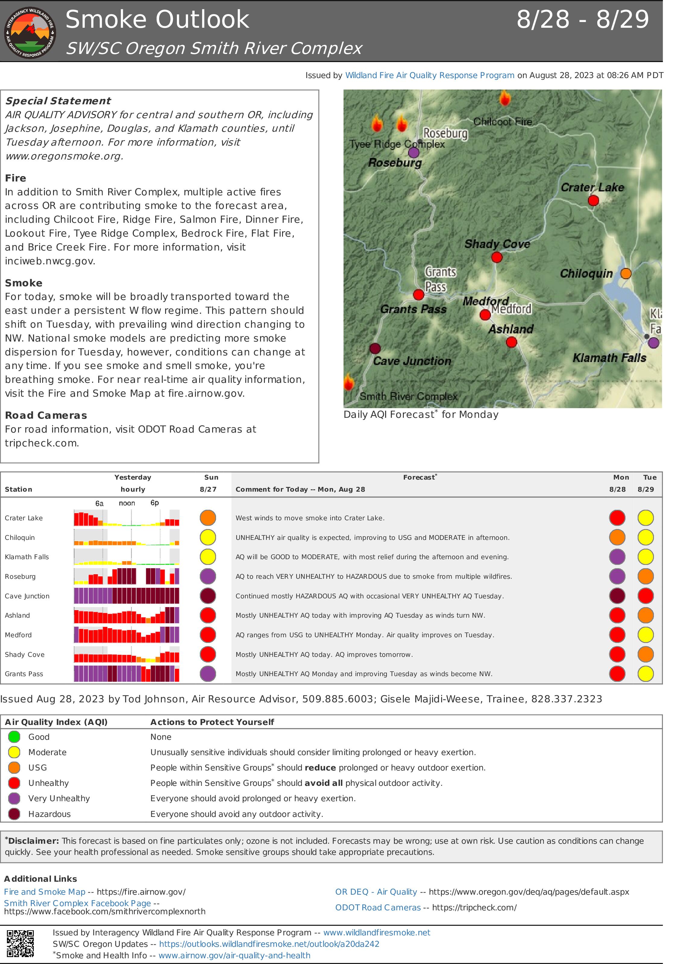
Smoke Outlook 828 829 Smith River Complex
Related Incident: Smith River Complex
Publication Type: News
Special Statement
AIR QUALITY ADVISORY for central and southern OR, including Jackson, Josephine, Douglas, and Klamath counties, until Tuesday afternoon. For more information, visit www.oregonsmoke.org.
Fire
In addition to Smith River Complex, multiple active fires across OR are contributing smoke to the forecast area, including Chilcoot Fire, Ridge Fire, Salmon Fire, Dinner Fire, Lookout Fire, Tyee Ridge Complex, Bedrock Fire, Flat Fire, and Brice Creek Fire. For more information, visit
inciweb.nwcg.gov.
Smoke
For today, smoke will be broadly transported toward the east under a persistent W flow regime. This pattern should shift on Tuesday, with prevailing wind direction changing to NW. National smoke models are predicting more smoke dispersion for Tuesday, however, conditions can change at any time. If you see smoke and smell smoke, you're breathing smoke. For near real-time air quality information, visit the Fire and Smoke Map at fire.airnow.gov.
Road Cameras
For road information, visit ODOT Road Cameras at tripcheck.com.
2023 Six Rivers National Forest Lightning Complex and Redwood Lightning Complex Update 82823
Related Incident: 2023 SRF Lightning Complex and Redwood Lightning Complex
Publication Type: News
2023 Six Rivers National Forest Lightning Complex and Redwood Lightning Complex August 28, 2023 – California Incident Management Team 2 is in command of the Six Rivers National Forest (SRF) 2023 Lightning Complex and Redwood Lightning Complex, which is now comprised of 18 fires. CIIMT2 has taken command of the Marlow Fire from the Smith River Complex due to its proximity to the Blue Creek 2. Total acreage is estimated at 10,969.4 acres with containment at 15%.
Fires in the Redwood National and State Parks Area
Lost – 40% contained. 722 acres. Crews continue full suppression tactics on this fire which is burning in the Lost Man watershed. CAL FIRE and Green Diamond Resource Company are collaborating in suppression efforts. Most the fire is in previously logged, second growth forest. Crews have held the fire on Holter Ridge. A small portion of the fire has slowly spread downslope into old growth redwood forest, where higher humidity has reduced fire activity.
Bridge Ridge – 17-acres burning near the Devil Fire with poor accessibility. Crews expect to have the fire contained by the end of the day.
The Glen Fire (0.1 acre) and Devil Fire (12.4 acres) are 100 percent contained and in patrol status.
Fires in the Hoopa Area
Lone Pine – 90% contained. 1,684 acres. The fire is smoldering with isolated areas of heat and minimal growth. The line has been mopped up 100-150 feet deep. Crews are removing unused hose lines.
Fires in the Orleans Area
Pearch - East of Orleans is estimated at 2,278 acres. Yesterday, crews began a firing operation along the south side of the fire. They continue to prepare for a burning operation along the west side of the fire to prevent the fire from a westerly spread towards Orleans. Structure protection personnel are continuing structure protection activities throughout the area. Hose line and sprinklers have been deployed around values at risk.
The Creek (8 acres), Flat (2.4 acres), Iron (20 acres), and Blue Creek (0.1-acre) are contained and in patrol status.
Merrill Mountain – 2 acres near the 12N08 Road. The team expects this fire will be in patrol status by the end of today.
The following fires are unstaffed due to difficult terrain and Firefighter safety: Monument (2 acres) Hancock (607 acres) Located in the Wooley Creek area within the Marble Mountain Wilderness. Point protection measures were put in place to protect values at risk in Wooley Creek. Let er-Buck Fire (42 acres).
Mosquito - Near the Bluff Creek area north of Mosquito Lake is estimated at 1,945 acres. The fire remains north of Forest Road 11N19 and west of Forest Road 12N12 (Cedar Camp Road). Containment lines along the 12N12 Road have held. Crews continue constructing containment lines.
Bluff #1 – 1,419 acres with minimal movement. Firing operations have been utilized to assist with line construction along the 11N16 Road.
Creek 2 (976 acres)
Marlow (1,106 acres)
Visit this link to access all resources listed on this update: www.linktr.ee/srffirepio
Pearch Fire Evacuation Warning:
Orleans Area:
Zone HUM-E009 (Southeast of the Klamath River in Orleans) Zone HUM-E008-B (Community of Orleans, west of Klamath River. East of Crawford Creek, including Orleans proper). Hwy 96 and Red Cap Road along the east bank of Klamath River, south from Salmon River, east to Orleans Mountain. Approximately 243 residents live in these 2 zones. Somes Bar Area: Zone SIS-1701: NORTH of Monte Creek Road, SOUTH OF Camp Three Road, EAST OF Camp Three Road, WEST OF Wooley Creek Trailhead. Anyone in these areas should be prepared for potential evacuations, including personal supplies and overnight accommodations. Be ready to go at a moment's notice.
Weather – Today’s weather will be similar to yesterday with low-level stratus below 1500-2000 feet. Cloud cover is expected to burn off in the early afternoon except for along the coast.
Closures:
Six Rivers National Forest: Area and campground closures are in effect on Six Rivers National Forest. A new Closure Order was issued for the Orleans Ranger District and a portion of the Lower Trinity Ranger District. They can be found at: https://www.fs.usda.gov/detail/srnf/notices/?cid=FSEPRD1096395.
Redwood National Park and State Park: There are multiple closures in the parks due to several fires, including closures in the Lost Man area.
For a full list of closures and impacts, please visit www.nps.gov/redw/planyourvisit/conditions.htm
Alert Notifications:
ZoneHaven/Genasys for map and zone identification: https://protect.genasys.com
Humboldt County Residents Register for Humboldt Alert Notification: www.humboldt.gov/alerts
Siskiyou County Resident Register at Code Red Alert Notification: https://public.coderedweb.com/CNE/en-US/6F327CCDFFFD
Redwood National and State Parks Information Hotline
Phone: 707-464-6101
https://www.nps.gov/redw/planyourvisit/conditions.htm
2023 SRF Lightning Complex Fire Information
Phone: 530-536-0767
Email: 2023.lightningcomplex@firenet.gov
Hoopa Information Hotline
Phone: 530-618-2995
Email: serene.oes@gmail.com
California Interagency Incident Management Team 2 will host a community meeting on Monday, August 28, 2023, at 4:00 pm. The meeting will be held in person at the Karuk Department of Natural Resources, 39051 Highway 96, Hoopa, CA If bandwidth allows, the meeting will also be streamed via Facebook Live at: https://www.facebook.com/SixRiversNF
Tiger Island Fire Daily UPdate 8282023
Related Incident: Tiger Island Fire
Publication Type: News
Hours: 8 am-8 pm Phone: 318-239-9263 Email: 2023.TigerIsland@firenet.gov InciWeb: htps://inciweb.nwcg.gov/incident-informa?on/lalas-?ger-island-fire
Facebook: htps://www.facebook.com/TigerIslandFire
Tiger Island Fire: The Tiger Island Fire was first reported on Tuesday August 22nd. The fire is located east of Merryville, south of Hwy 190, SW of DeRidder and North of Singer. The fire is burning in pine planta?ons of mul?ple ages and access to por?ons of the fire area is difficult and fuel loads in these pine planta?ons are high. Heavy residual fuels as a result of Hurricane Laura in 2020 exist and contribute to extreme fire behavior.
Acreage: 33,294 acres Containment: 50%
Personnel and Equipment: 180 total personnel; 8 Helicopters, 10 Type-6 Engines, 10 Type-2 Tractor Plow Units, and 15 Dozers. Addi?onal support is being provided by the Na?onal Guard, Parish authori?es, the Governor’s Office of Homeland Security and Emergency Preparedness, the Louisiana State Fire Marshal Team, Beauregard Sherriff’s office, and the Office of Emergency Preparedness. The Na?onal Guard is suppor?ng with Black Hawk helicopters and 16 dozers and the fire response is using Large Air Tankers, Scoopers and Air Atack from Texas.
Today: With many addi?onal personnel and equipment arriving yesterday, the focus for opera?ons will be to con?nue to establish dozer lines as direct as possible to the fire edge, mop up areas of heat and to con?nue work on iden?fying structures and ensuring structure protec?on is in place. Along the northern edge of the fire, crews will work to keep the fire south of Stamps Road and Shins Road and west of Schuetz Road. Several spot fires were iden?fied yesterday west of Schuetz Road and dozers lines were quickly established to contain those spots. These areas will con?nue to be monitored today. Fire personnel will con?nue to work twenty-four hours with day and night shi? opera?ons.
Weather and Fire Behavior: Night opera?ons reported light rain over parts of the Tiger Island Fire last night over a three-hour period resul?ng in minimal fire spread overnight a?er record high temperatures were reported across the region yesterday. Although this rain was not considered a “we?ng” rain across the fire, these condi?ons do provide a window of opportunity for the firefighters today. “We have an opportunity to catch two things today. We can catch a break and catch up,” shares Incident Commander Steve Parrish during the morning opera?ons briefing. The front that brought showers and storms yesterday will push south of the area today, reducing the chances of rain. A?ernoon highs will drop back into the middle 90s with minimum rela?ve humidity dropping briefly into the 40% range. Overall, condi?ons will con?nue to be dry and hot, causing firefigh?ng efforts to con?nue to be challenging.
Evacua?ons: Updates on evacua?ons and shelters can be found on the Beauregard Parish Sheriff’s Office Facebook Page at htps://www.facebook.com/beauregardsheriff.