
Happy Camp Complex Incident Update August 29 2023 Morning
Related Incident: 2023 Happy Camp Complex Klamath NF
Publication Type: News
HAPPY CAMP COMMUNITY MEETING: A community meeting and fire operations update will be taking place today, August 29th at 5:30 p.m. at the Karuk Administration Gym located at 64236 Second Avenue, Happy Camp, CA 96039.
WEST SIDE OVERVIEW (ACRES/CONTAINMENT): Elliot (9,915 acres, 2%), Malone (741 acres, 7%), Ufish (2,148 acres, 0%)
Strategic firing operations towards Elk Creek Road took place on the Malone Fire last night. Today, firefighters will work to improve and hold progress made on securing fire lines. Last night on the Ufish Fire, winds were unfavorable for the planned strategic firing operation. Crews will be prepared to execute the plan today, as necessary. On the Elliot Fire, crews patrolled Highway 96 and mopped up hot spots near the fire line. Today, firefighters will continue to strengthen containment lines near Highway 96 and scout for indirect contingency lines on the north and west flanks of the fire.
EAST SIDE OVERVIEW (ACRES/CONTAINMENT): Head (6,931 acres, 45%), Block (0.1 acres, 100%), Townsend (81 acres, 100%), Den (294 acres, 100%), Scott (1,886 acres, 70%), Lake (199, acres, 5%)
Firefighters continue to make progress to the north and south of Hamburg on the Head Fire. On the north end, crews are working in steep terrain, through dense vegetation. Upcoming winds are expected to push the north end of the Head Fire back into its’ burned area today. CAL FIRE has made good progress on the Scott Fire. Both the Townsend and Lake fires have held within established containment lines.
EVACUATIONS: View current Siskiyou County evacuation orders and warnings by visiting: community.zonehaven.com. Siskiyou County residents are encouraged to sign up for rapid emergency notifications using the CodeRED emergency alert system. https://www.co.siskiyou.ca.us/emergencyservices/page/codered-emergency-alert
An evacuation center has been established at the Kahtishraam Wellness Center, 1403 Kahtishraam, Yreka, CA 95097. Call (530) 340-3539 if you have questions regarding the shelter.
ROAD CONDITIONS: State Route 96 is now open. One-way traffic control remains in place in several areas while crews work to repair damaged infrastructure, remove debris, and stabilize slopes. Delays at the locations with one-way traffic control could be up to an hour or more. The road will be closed to the public east of Seiad daily from 8:00 a.m. to 9:00 a.m. and from 6:30 p.m. to 8:00 p.m. to facilitate fire traffic. For the exact locations of where this work is taking place, please use quickmap.dot.ca.gov. County road closures will be listed on the Siskiyou County Public Works website: https://www.co.siskiyou.ca.us/publicworks/page/closures-and-delays.
FOREST CLOSURE: Two closure orders have been implemented: Happy Camp Complex Emergency Fire Closure, No.05-05-23-06; Happy Camp Complex Emergency Fire Closure, No. 05-05-23-07. Please refer to https://www.fs.usda.gov/alerts/klamath/alerts-notices to view the orders and maps.
TEMPORARY FLIGHT RESTRICTION (TFR): A TFR has been established over the fire area. Flight restrictions include the use of drones. The operation of drones under the TFR is prohibited.
PACIFIC CREST TRAIL: The Pacific Crest Trail is closed between the Shelly Fork Junction and Seiad as part of an area closure under Forest Order 05-05-23-07. It is suggested that northbound through-hikers exit the trail at Etna Summit and resume northward travel from Seiad.
AIR QUALITY: For information regarding smoke impacts and what you can do to protect yourself, visit: https://www.airnow.gov/
Lookout Bedrock Horse Creek Pothole Fires Daily Update 08292023
Related Incident: Lookout Fire2023 Horse Creek FireBedrock Fire
Publication Type: News
August 29, 2023
Morning Update
Community Public Meeting: There will be an in-person community meeting Wednesday, August 30, 2023, at 5:00 p.m. at the McKenzie High School in McKenzie Bridge, Oregon. There will be a question-and-answer session following the presentations. For those who cannot attend, the meeting will be recorded and posted on both the Bedrock Fire https://www.facebook.com/BedrockFire2023/ and Lookout Fire pages https://www.facebook.com/LookoutFire2023/. Information officers will monitor and answer incoming questions.
Public reminder: Willamette National Forest closure orders remain in place around all four fire areas. These closures help provide firefighters with safer driving conditions and decrease the potential for search and rescue operations that could interrupt firefighting activities. Please see links to this information below.
Horse Creek, Lookout, Pothole Fires Total Personnel: 937
Resources: 54 engines l 15 crews l 13 bulldozers l 29 water tenders l 11 masticators l 8 helicopters
Horse Creek: Size: 597 acres l Start Date: August 24, 2023 l Cause: Lightning l Containment: 0%
Fire behavior was limited yesterday morning but picked up in the late afternoon when the marine layer lifted over the fire. Fire crews, equipment, and air resources are actively engaged in full suppression efforts in the Horse Creek drainage. Firelines on the north and west edges are holding well. The fire has been moving eastward due to terrain and winds. Some dozers and hand lines have been installed to check eastern fire spread. Today, as conditions allow, firefighters will fly a drone above the fire to detect hotspots near the fire’s edge.
Lookout: Size: 22,317 acres l Start Date: August 5, 2023 l Cause: Lightning l Containment: 17%
Cooler temperatures and higher humidity helped moderate fire behavior allowing firefighters to make good progress. Along the northern, western, and eastern flanks of the fire; fuel breaks are being prepared by tree fallers, fire crews, and heavy equipment along forest system roads that are being utilized as primary and alternate control lines to contain fire spread. On the southeast flank, near Belknap Springs, the fire has been slowly backing downhill toward completed containment lines near Highway 126. Where containment lines are confidently secured along the south edge, crews are beginning to remove unneeded fire equipment like fire hose and pumps, while continuing to hold and secure the fireline. Of particular concern for the safety of firefighters, are both live and dead trees falling near work areas.
Pothole: Size: 99 acres l Start Date: August 25, 2023 l Cause: Lightning l Containment: 0%
This fire is adjacent to the Three Sisters Wilderness. Yesterday firefighters installed critical direct fireline to contain fire on the northwest corner. Today they will continue identifying options to build fireline around the remainder of the northern flank.
Bedrock: Size: 31,592 acres l Start Date: July 22, 2023 l Cause: under investigation l Containment: 71%
Total Personnel: 696
Resources: 35 engines l 12 crews l 8 bulldozers l 27 water tenders l 8 masticators l 11 helicopters
There was no measurable growth on the Bedrock Fire yesterday. Firefighters continue to secure portions of the containment line along the northwest area of the perimeter. Across most of the fire, the focus has shifted to hauling out equipment, firehose, and pumps and repairing damage to the land and forest roads (grading, installing water bars, and re-contouring dozer lines).
All Fires
Cooler temperatures and higher humidity yesterday resulted in minimal fire growth on all fires. Firefighters and law enforcement officers maintain a presence in evacuated areas. Trained firefighters are flying Unmanned Aerial Systems (UAS) or drones through the smoke to provide infrared heat imaging to locate hotspots near control lines. Drones also support firing operations in areas that are hard to access, which reduces risk to firefighters.
Weather
Light rain is predicted over the fires today. Winds from the west may be gusty along ridgetops and where river and creek drainages align with winds. This condition often results in increased fire behavior where winds and drainages align. Cool, moist onshore flow is expected to continue through Labor Day.
Evacuation Centers: An evacuation center is in place at Westridge Middle School in Oakridge for evacuees and small pets from the Bedrock and Lookout Fires. A large animal shelter is established at the Lane County Fairgrounds in Eugene.
An up-to-date and searchable evacuation map is available through Lane county’s website.
Lane County Evacuations: https://www.lanecountyor.gov/cms/one.aspx?pageId=19729054
Linn County Evacuations: https://www.linnsheriff.org/
Road Closures: Highway 242, McKenzie Highway, is closed between milepost 61-76, 14 miles west of Sisters, Oregon to just east of the junction with Highway 126. Highway 126 is currently open. Please monitor Trip Check for any updates at: https://tripcheck.com/
Forest Closures: Closures can be found at: https://www.fs.usda.gov/detail/willamette/alerts-notices/?cid=fseprd552029
Restrictions: Fire Restrictions are in place on the Willamette National Forest: https://www.fs.usda.gov/willamette. Temporary Flight Restrictions remain in place over the Bedrock and Lookout fire areas.
Smoke Outlook: https://outlooks.wildlandfiresmoke.net/outlook/4c92bc1a The Fire and Smoke Map (fire.airnow.gov) is another source for air quality information.
Lookout Information Line: 541-215-6735 (8am-8pm)
Email: 2023.lookout@firenet.gov
Facebook: https://www.facebook.com/LookoutFire2023
Inciweb: https://inciweb.nwcg.gov/incident-information/orwif-lookout-fire
Bedrock Fire Information: 541-414-6272 (8am-8pm)
Email: 2023.bedrock@firenet.gov
Facebook: https://www.facebook.com/BedrockFire2023/
InciWeb Bedrock: https://inciweb.wildfire.gov/incident-information/orwif-bedrock-fire
Informacin al da para el Incendio Flat y Incendio Anvil 29 de Agosto 2023
Related Incident: Flat Fire
Publication Type: News
Incendio Flat
Extensión: 34,242 acres
Origen: 2 millas Sureste de Agness, OR
Contencion: 58%
Fecha de Inicio: `15 de Julio, 2023
Personal: 381
Recursos: 11 escuadrillas de bomberos l 3 helicópteros l 17 camiones de bomberos l 3 buldóceres l 16 cisternas l 4 máquinas masticadoras
Actividades para el día de hoy: El incendio se mantiene en el mismo lugar permitiendo a los bomberos hacer progresos significativos con los esfuerzos de supresión. El trabajo continuo de reparación abarcando los campamentos de Oak Flat, las carreteras y los senderos ayuda a la estabilización del área después del trabajo de supresión y minimiza el impacto del incendio sobre los recursos naturales. Los recursos que trabajan sobre el terreno aunados al apoyo aéreo continúan patrullando y monitoreando toda el área del incendio. El domingo, una escuadrilla de bomberos encontró algunas fuentes de calor en el lado Sur del incendio respondiendo rápidamente con operaciones de supresión. Un grupo de Ataques Iniciales (IA) compuesto de varios recursos del Incendio Flat continúa apoyando la Unidad Local en el Incendio Cedar el cual está localizado al Norte del Incendio Flat.
Informe matutino del Incendio Anvil:
Extensión: 25.6 acres
Origen: 8 millas Este de Port Orford, OR
Contención: 0%
Fecha de Inicio: 25 agosto, 2023
Personal: 52
Recursos: 2 escuadrillas de bomberos l 2 helicópteros l 12 rapeles l 1 camión de bombero l 1 buldócer
Actividades para el día de hoy: Buen progreso se continúa realizando en el Incendio Anvil en donde los trabajadores sobre el terreno y desde las aeronaves se enfocan hacia una supresión total. El fuego esta localizado sobre terrenos escarpados y algunas veces inaccesibles, dificultándose para los bomberos el introducirse por tierra. En horas tempranas del sábado, CFPA brindo su apoyo utilizando la máquina de buldócer local para limpiar una carretera vieja de asfalto en las afueras de la frontera de las tierras vírgenes. De esta forma, abrieron camino acerca de 1.25 millas adicionales en donde logaron bajar a las escuadrillas y suministros, ahorrándoles la mitad de la distancia a caminar. Al final del turno nocturno de la noche de ayer, con 12 rapeles en el lugar, los recursos lograron completar la línea aldedor del incendio. Los recursos aéreos continúan apoyando, pero la baja visibilidad limita de vez en cuando en los periodos operacionales. No se llevarán a cabo trabajos utilizando la ayuda de buldóceres dentro de las tierras vírgenes. El lunes, los bomberos evaluaron la línea de retardantes de incendio, enfocados en asegurar el eje y a su vez limpiar el área. Ese mismo día, arribaron mas recursos incluyendo escuadrillas de trabajadores a mano y maquinas masticadoras. El incendio localizado en las tierras vírgenes de Grassy Knob se esta quemando dentro de un bosque antiguo, aproximadamente 23 millas al Noroeste del Incendio Flat.
Condiciones climáticas: Durante los próximos días, un clima más templado deberá ayudar a mantener una actividad mínima en el incendio debido al enfriamiento en la temperatura y en el incremento de los niveles de humedad. Un frente frio traerá consigo temperaturas ligeramente frescas para el lunes y martes, así como también una incrementación ligera de los vientos del Noroeste.
Condiciones de humo: La prolongación del humo dentro del área está desplazándose hacia el Norte extendiéndose desde el Incendio Smith River Complex y asentándose en las comunidades cercanas como Brookings. Información acerca de las perspectivas de Humo se encuentran disponibles en:https://bit.ly/SWORNWCALsmoke
Ordenes de Cierres: El U.S. Highway 199 ha sido cerrado al Norte de Gasquet debido a incendios en el Bosque Nacional de Six Rivers, por favor use la ruta U.S. Route 101 hacia SR 42s para viajar hacia y desde Rogue Valley. Las carreteras del Servicio Forestal y BLM no deberán ser utilizadas como rutas alternativas debido a la actividad de surgimiento de incendios en la zona. El Bosque Nacional de Rogue River-Siskiyou ha declarado una orden de cierre incluyendo senderos, caminos y una porción del área de Illinois River. Información acerca los cierres en el área del Incendio pueden encontrarse en: https://bit.ly/RRSNFAlerts
Evacuaciones: Se mantiene un Nivel 1 “Prepárese” para todas las áreas en las proximidades del Incendio Flat. Para más información: https://bit.ly/CurryCoEM
Orden de restricción: Actualmente, el Nivel de Peligro de Incendio es “Extremo”. El Bosque Nacional de Rogue River-Siskiyou implemento un Nivel 3 en las Restricciones para el Uso Público (PURs). Asimismo, se encuentra en pie un Nivel 3 (PURs) para la Sección Nacional Virgen de Rogue que fue implementada por el Bosque Nacional de Rogue River-Siskiyou, BLM en Medford y ODF. Para mayor información visite:https://bit.ly/RRSNFnews
Camp Creek Fire Update for Tuesday August 29 2023
Related Incident: Camp Creek Fire
Publication Type: News
Fire Size: 1,607 acres
Containment: 0%
Total Personnel: 254
Weather and Fire Behavior:
Due to heavy cloud cover overnight the infrared mapping mission was unable to update the fire size, however firefighters report only modest growth to the east and south. The previous mission mapped the Camp Creek Fire at 1,607 acres. The fire remains at 0% containment.
Yesterday, firefighters continued to improve Forest Roads 12 and 14 to serve as primary containment lines and observed some backing and flanking fire spread despite the misty, cool conditions. Fire behavior analysts expect to see limited spread today with persistent burning due to how dry the large fuels are. Cool temperatures and partly to mostly cloudy conditions are predicted this week, with light rain expected through Wednesday. A second round of precipitation, forecasted Thursday through Friday, could bring even more rain, slowing fire activity and improving air quality. Fire behavior may be moderated by the cool and moist conditions, but heavy tree canopy will likely prevent rain from wetting the understory, allowing fuels like logs and timber litter to smolder and creep due to long-term seasonal dryness.
Operations:
Firefighters will continue to implement protection measures around the Portland Water Bureau water treatment infrastructure and minimize the impacts to the Bull Run Watershed. Additional crews, engines, and heavy equipment ordered by the Great Basin Incident Management Team have been arriving, bringing the total number of fire personnel to 254. Additional resources will continue arrive daily.
Firefighters plan to lay hoses, along constructed handline, connecting Forest Roads 12 and 14 where possible. This will help box in the fire and prevent progression to the north, west and south. Managers will assess potential future locations for a possible strategic burnout of fuels that would create a more solid blackline between containment lines and the fire’s edge. In order to better monitor the changes in temperatures, humidity, and precipitation in various parts of the fire, crews will be adding two more Remote Automatic Weather Stations (RAWS) in the field today: one near Hickman Lookout and one at Bear Creek House.
A night shift has been added to patrol and monitor for any spotting or increased activity throughout the evening. Scoopers and large helicopters remain available to support ground crews when conditions allow. An Unmanned Aircraft System (UAS) and accompanying crew is expected to arrive later in the week to assist with operations.
A community meeting is scheduled for 6:30 p.m. Tuesday evening at Columbia Grange 267, 37493 NE Grange Hall Rd, Corbett, OR 97019. The meeting will be livestreamed on Facebook Live at: https://www.facebook.com/campcreekfire
Additional Information:
Check current Air Quality at Air Now: https://www.airnow.gov/?city=Sandy&state=OR&country=USA
Information regarding the fire’s effect on the Bull Run Watershed: https://www.portland.gov/water/camp-creek-fire
Closures and Evacuations:
Currently there are no fire related closures or evacuations, but people in the area should be prepared for both. Clackamas County residents can sign up to receive critical emergency messaging via email, phone call, and text: https://www.clackamas.us/dm/publicalerts
Temporary Flight Restrictions (TFR): There is a TFR over the fire area and public drone use is illegal.
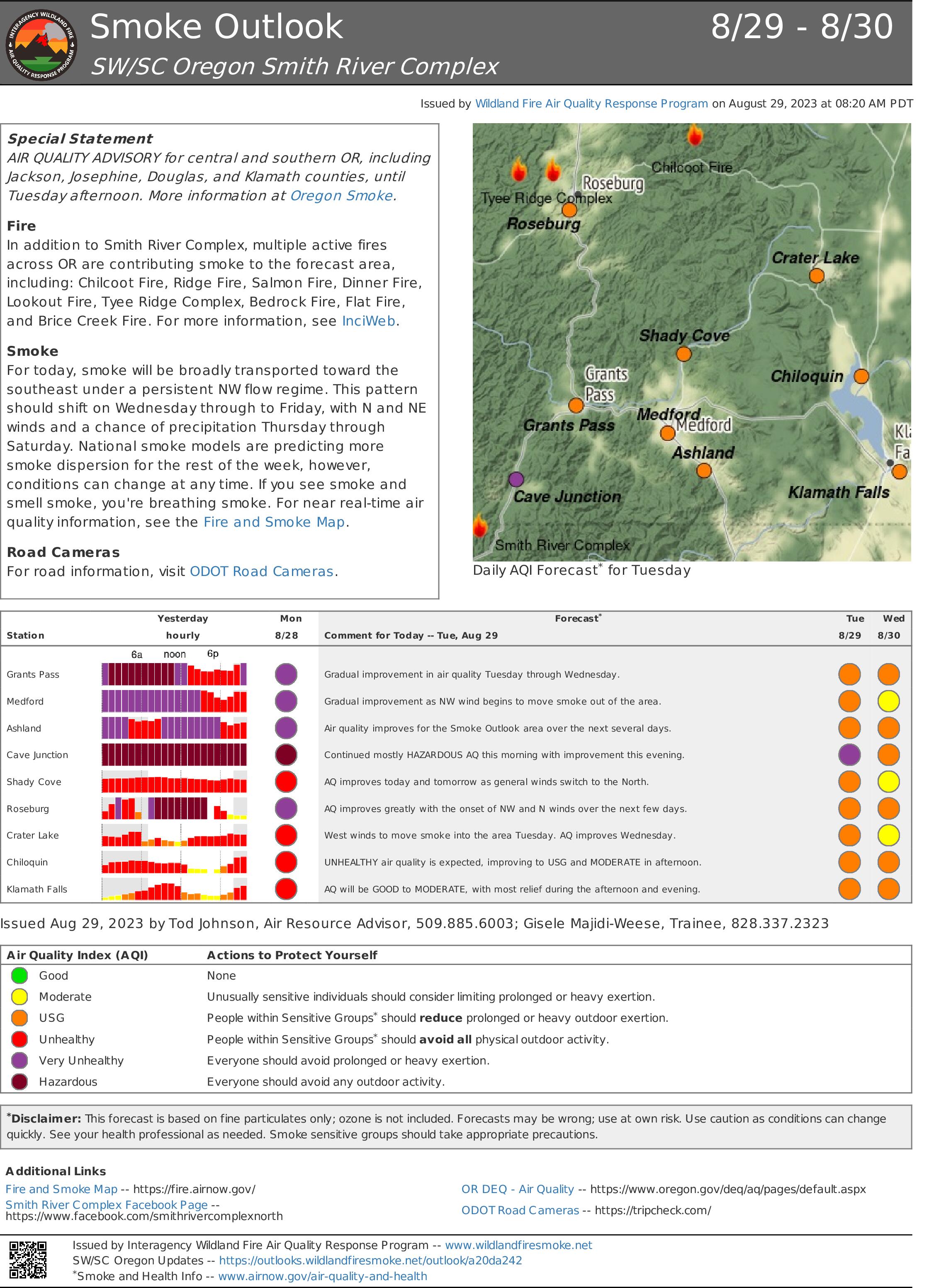
Smoke Outlook 829 830 Smith River Complex
Related Incident: Smith River Complex
Publication Type: News
Special Statement
AIR QUALITY ADVISORY for central and southern OR, including Special Statement AIR QUALITY ADVISORY for central and southern OR, including Jackson, Josephine, Douglas, and Klamath counties, until Tuesday afternoon. More information at Oregon Smoke.
Fire
In addition to Smith River Complex, multiple active fires across OR are contributing smoke to the forecast area, including: Chilcoot Fire, Ridge Fire, Salmon Fire, Dinner Fire, Lookout Fire, Tyee Ridge Complex, Bedrock Fire, Flat Fire, and Brice Creek Fire. For more information, see InciWeb.
Smoke
For today, smoke will be broadly transported toward the southeast under a persistent NW flow regime. This pattern should shift on Wednesday through to Friday, with N and NE winds and a chance of precipitation Thursday through Saturday. National smoke models are predicting more
smoke dispersion for the rest of the week, however, conditions can change at any time. If you see smoke and smell smoke, you're breathing smoke. For near real-time air quality information, see the Fire and Smoke Map.
Road Cameras
For road information, visit ODOT Road Cameras.
Flat Fire and Anvil Fire Daily Update 08292023
Related Incident: Flat Fire
Publication Type: News
Flat Fire
Size: 34,242 acres
Start Date: July 15, 2023
Point of origin: 2 miles southeast of Agness, OR
Containment: 58%
Total personnel: 381
Resources: 11 crews l 3 helicopters l 17 engines l 3 bulldozers l 16 water tenders l 4 masticators
Today’s Activities: The fire remains within its footprint giving crews the ability to make meaningful progress with suppression efforts. Ongoing repair work, including by Oak Flats campground, roads, and trails helps stabilize the area after suppression work and minimizes the fire’s impact to natural resources. Ground resources along with aerial support continue patrolling and monitoring. On Sunday, crews discovered some heat on the south side of the fire and quickly suppressed those areas. An Initial Attack (IA) group consisting of several Flat Fire resources continue to support the local unit on the Cedar fire located north of the Flat Fire.
Anvil Fire
Size: 25.6 acres
Start Date: August 25, 2023
Point of origin: 8 miles east of Port Orford, OR
Containment: 0%
Total personnel: 52
Resources: 2 crews l 2 helicopters l 12 rappelers l 1 engine l 1 bulldozer
Today’s Activities: Good progress continues to be made on the Anvil Fire as ground crews and aircraft work in tandem to move toward full suppression. The fire is located in steep, and in some areas, inaccessible terrain making access difficult by ground. CFPA provided support with their local dozer early Saturday to clear an old roadbed outside of the wilderness boundary, gaining an additional 1.25 miles of drivable access to deliver crews and supplies cutting the hike in half. Working with the 12 Rappelers on scene, resources were able to complete line around the fire by end of shift last night. Aircraft continue to support the incident, but low visibility has limited work at times during the operational periods. No dozer work will be conducted within the wilderness. On Monday, crews assessed retardant line, focused on securing fire edge, and mopped up. Additional resources, including hand crews and masticators arrived on the fire Monday. The fire, located within the Grassy Knob Wilderness is burning in old growth timber approximately 23 miles northwest of the Flat Fire.
Weather: Milder weather over the next few days should help keep fire activity to a minimum due to cooler temperatures and increased humidity levels. A dry cold front will bring slightly cooler temperatures Monday and Tuesday along with a slight increase in northwest winds.
Smoke: Smoke lingering within the area is moving north from the Smith River Complex and settling within some nearby communities, like Brookings. The smoke outlook for the Smith River Complex is available at: https://bit.ly/SWORNWCALsmoke
Closures: U.S. Highway 199 has been closed north of Gasquet due to fires on the Six River National Forest, please use U.S. Route 101 to SR 42 for all travel to and from the Rogue Valley. Forest Service and BLM roads should not be used as alternate routes due to emerging fire activity. The Rogue River-Siskiyou National Forest (RRSNF) has issued a closure order for the fire area including trails, roads, and a portion of the Illinois River. Visit https://bit.ly/RRSNFAlerts for more information.
Evacuations: Level 1 “Get Ready” evacuation status in place for areas in the vicinity of the Flat Fire. Link to more information: https://bit.ly/CurryCoEM
Restrictions: Fire danger is currently extreme; the RRSNF is implementing Level 3 Public Use Restrictions (PUR). Level 3 PURs on the Wild Section of the Rogue River have been implemented by the RRSF, Medford BLM and ODF. More information: https://bit.ly/RRSNFnews
Smith River Complex South Spanish Update August 29 2023
Related Incident: Smith River Complex
Publication Type: News
Fecha de inicio: Aug 15, 2023
Localizado: Bosque Nacional Seis Ríos
Causa: Relampagos
Hectáreas: 73,799
Contención: 7%
Personal: 2,780
Gasquet, Calif., Agosto 29, 2023. Ayer, los recursos contra incendios continuaron sus esfuerzos para contener y asegurar la mayor parte del perímetro de los incendios antes de que las condiciones cambien a un patrón desfavorable de corta duración a partir de la madrugada del miércoles. Las cuadrillas completaron la operación de quema desde French Hill Road hacia el norte hasta la autopista 199. Este fue un esfuerzo extenso tanto de los motores como de las cuadrillas de expertos para construir la línea de control, sondearla con manguera y quemar con éxito casi 1 milla de línea en pendiente. terreno accidentado. Esta operación probablemente evitará que el incendio continúe avanzando hacia el oeste hasta las estructuras a lo largo de French Hill Road.
Los recursos continuaron asegurando y absorbiendo el calor alrededor de la línea de topadoras en el lado noreste del vecindario de North Fork y alrededor de las estructuras a lo largo de Pioneer Road. En la División YY, los equipos trabajaron para mantener el incendio Coon al oeste de la carretera 405, la principal línea de contención planificada tanto para el incendio Coon como para el flanco sur del incendio Kelly.
El martes será un día de transición de patrones climáticos con vientos más fuertes del noroeste por la tarde y menos intrusión marina. Los vientos cambiarán a dirección mar adentro el martes por la noche y permanecerán fuera del noreste hasta el miércoles por la noche. Esto traerá un período de condiciones climáticas de incendio casi críticas el miércoles con vientos más fuertes y una humedad relativa más seca. Los recursos contra incendios han estado trabajando arduamente en preparación para este evento, incluida la rotación de personal en un turno nocturno robusto que se concentrará en defender las estructuras. El patrón climático volverá rápidamente a un patrón húmedo el jueves por la noche con nubes crecientes, posibilidad de lluvias ligeras y flujo hacia la costa a medida que una vaguada en el nivel superior del noroeste del Pacífico se adentre en el área.
Evacuaciones
Todas las órdenes de evacuación son emitidas por la Oficina del Sheriff del Condado de Del Norte. Si se encuentra en el área del condado de Del Norte, regístrese para recibir su Community Alert System para recibir notificaciones de emergencia. Niveles de evacuación al 27 de agosto a las 8:00 a.m., como sigue:
Nivel 3 “Vaya ahora”: Patrick Creek, Little Jones Creek, Copper Creek Drainage, Coon Creek/ 16n19 17n07, Washington Flat, Pioneer Road, Panther Flat Campground Area, todas las comunidades entre Slant Bridge Road al norte hasta la frontera de Oregón a lo largo de la autopista 199, Camino de la colina francesa.
Nivel 2 “Prepárate”: División baja, División alta, Rowdy Creek, Big Flat/Rock Creek.
Nivel 1 “Esté preparado”: Hiouchi desde Slant Bridge hasta el extremo este de North Bank Road.
Cierres
South Fork Road está abierta únicamente para residentes. El residente debe proporcionar prueba de residencia.
Rowdy Creek Road permanece cerrada en la parte superior de Low Divide.
Howland Hill Road (solo residentes)
Carretera del condado 316, Shelly Creek,
County Road 315 Mina de vacaciones
Carretera del condado 311 Antigua carretera de peaje de Gasquet
Carretera del condado 305 Weimer Road
Carreteras del Servicio Forestal 16N19 y 17N07
La autopista estadounidense 199 está cerrada en el condado de Del Norte desde Slant Bridge Road hasta Oregon Mountain Road (PM 16 a 31) debido a la actividad del incendio. Existe un cierre estricto en la U.S. 199 en la Estación Agrícola cerca de la frontera con Oregón. Para conocer las últimas condiciones de la carretera, visite quickmap.dot.ca.gov
A partir del domingo 20 de agosto de 2023, el Bosque Nacional Six Rivers ha emitido una orden de cierre de todo el bosque. https://www.fs.usda.gov/detail/srnf/notices/?cid=FSEPRD1096395
La Cruz Roja Estadounidense tiene un refugio en el recinto ferial del condado de Del Norte (421 US-101 N, Crescent City, CA 95531) para los desplazados por las evacuaciones. Los trabajadores de desastres de la Cruz Roja se están asociando con funcionarios locales para ayudar a garantizar que los evacuados reciban las necesidades, incluidos alimentos, agua y refugio.
Más información
Complejo del río Smith Inciweb: inciweb.nwcg.gov/incident-information/casrf-smith-river-complex
Bosque Nacional de los Seis Ríos: https://www.facebook.com/SixRiversNF
Oficina de Servicios de Emergencia Del Norte: https://www.facebook.com/DelNorteOfficeOfEmergencyServices
Oficina del Sheriff del Condado de Del Norte: https://www.facebook.com/DelNorteCountySheriffDepartment
Complejo del Río Smith Norte: https://www.facebook.com/smithrivercomplexnorth
Bosque Nacional Rogue River-Siskiyou: https://www.facebook.com/R6RRSNF/
Manejo de Emergencias del Condado de Josephine: https://www.facebook.com/josephinecountyEM
Para obtener un mapa de evacuación interactivo, visite: https://rvem.org/.
Valentine Fire Daily Update Tuesday August 29 2023
Related Incident:
Publication Type: News
Local Type 4 organization to assume command of the Valentine Fire
August 29, 2023 – Daily Update
Size: 14 acres
Start Date: August 16, 2023
Cause: Lightning
Completion: 30%
Total personnel: 234
Location: 11 miles northeast of Young, Arizona and 27 miles east of Payson, Arizona
Fuels: Hardwood litter and timber
Highlights: Last night, the Southwest Area Type 2 Incident Management Team 4 hosted a community meeting in Christopher Creek to share updates and information about the Valentine Fire. Over 60 community members attended the meeting to hear presentations from the incident management team and the Tonto National Forest, followed by a question and answer session. At 7:00 PM on Tuesday, August 29, Team 4 will transfer command of the Valentine Fire to a local Type 4 organization, led by Incident Commander David Rasmussen. Team 4 extends its sincere thanks to the local communities for their support, gratitude, and hospitality throughout this incident. Firefighters are either demobilizing to return to their home units or reassigning to assist other wildfires across the country.
Future Fire Information: The Valentine Fire Information phone number and email address will no longer be active after 7:00 PM on Tuesday, August 29. For future updates, please contact the Tonto National Forest Public Affairs Office at SM.FS.TontoPIO@usda.gov or 602-525-1042. This will be the final update for the Valentine Fire.
Operations: The size of the Valentine Fire remains at 14 acres, and firefighters have successfully increased the completion of operational objectives to 30%. Remaining crews are continuing to conduct road maintenance and repair dozer lines around the planning area. The objectives achieved on the Valentine Fire, including line preparation and point protection, were designed to support the Forest Service Wildfire Crisis Strategy, a national strategy to address the wildfire crisis in places where it poses the most immediate threats to communities. To learn more about the Wildfire Crisis Strategy, please visit: https://www.fs.usda.gov/managing-land/wildfire-crisis.
Weather: Conditions will be mostly clear in the morning with a pronounced morning inversion. Temperatures will rise to above normal levels in the upper 80s to lower 90s this afternoon with continued dry conditions. A light northeast wind in the morning will transition to the southwest then west by late afternoon. Cumulus clouds will develop late morning through the afternoon, although chances of any rain are very low (15%). Relative humidity this afternoon will drop into the 20-25% range after moderate overnight recoveries.
Closures: The Tonto National Forest has issued an emergency area closure for the Valentine Fire. The purpose of the closure order is to protect public health and safety during the Valentine Fire, and to protect assigned firefighting personnel engaging in wildland firefighting operations. The full closure order (No. 03-12-05-23-22) and map are available on the Tonto National Forest website: https://www.fs.usda.gov/alerts/tonto/alerts-notices/?aid=82769.
Safety: The health and safety of firefighters and the public are always the first priority. Members of the public should stay away from Valentine Fire operations. The Temporary Flight Restriction over the fire area has now been lifted.
Smoke: Smoke has become less visible as rainstorms have moved into the Valentine Fire area. An interactive smoke map at https://fire.airnow.gov/ allows you to zoom into your area to see the latest smoke conditions.
Fire updates are posted on InciWeb and the Tonto National Forest Facebook and Twitter
Email: 2023.valentine@firenet.gov • Phone: (928) 588-4033 • Office Hours: 8:00 AM – 8:00 PM
Oregon Fire Update 29 August 2023
Related Incident: Oregon Fire
Publication Type: News
Oregon Fire Update - August 29, 2023
Size: 10,817 acres
Start Date: 18 August 2023, 1600hrs
Point of origin: Under Investigation
Containment: 79%
Cause: Under Investigation
Total Personnel: 562
Resources: 43 engines |13 crews |5 bulldozers |8 water tenders |1 helicopters |4 skidgens
Current Situation: The strategy of the fire remains full suppression. Most sections of the fire are now transitioning from mop-up activities to being patrolled. To further aid in residents’ return to their property, 24-hour operations will continue into Tuesday night but using a shorter shift so as to return those resources to the following day shift. Air resources continue to assist firefighters in hot spot detection, reconnaissance and water bucket drops on the east flank of the fire.
Today’s activities: Across the fire perimeter and interior, successful mop-up and suppression repair will lead to more areas shifting to a patrol status. Firefighters continue to make improvements to containment lines on the east flank of the fire. This area of the perimeter will continue to make use of engines, hand crews, air assets and skidgens as needed to work through mop-up. The south, west, and north flanks of the fire will all be patrolled as well as to seek and mop-up any hot-spots. Air assets will assist ground efforts if needed.
Pacific Northwest Incident Management Team 3 (PNW3) will transfer command of the fire to Northeast WA Incident Management Team (IMT) 3 at 6 a.m. on Wednesday, August 30. The two IMTs will work together over the next two days to insure a thorough and seamless transition.
Disaster assistance: Spokane County Emergency Management will host a community meeting focusing on debris management and clean-up tonight at 6 p.m. at Riverside High School, 4120 E. Deer Park - Milan Rd, Chattaroy, WA 99003. A fire update will also be provided. Resources are available through the Spokane County Disaster Assistance Center located at the Spokane Falls Community College, Building 9, 3305 W. Whistalks Way, Spokane, WA 99224 - phone: (509) 998-2750. Additional resources for property clean-up can be found at Spokane Regional Health and Spokane Air: bit.ly/44o05BX.
Evacuations: Only Level 1 evacuation zones remain in effect throughout the fire area. For updated evacuation maps of Spokane County go to www.facebook.com/GEGEmergencyMgt and for evacuation maps of Pend Oreille County go to www.facebook.com/pocsheriff. The evacuation center is currently located at Riverside High School 4120 E. Deer Park Milan Rd, Chattaroy, WA 99003.
Weather: Warm weather and gusty winds will arrive on Tuesday afternoon ahead of a cold front that is expected to push into the area by mid afternoon. Afternoon thunderstorms will likely come with gusty winds (up to 35-40 mph), small hail and heavy rain. 0.5” to 1.0" of rain is expected to fall over the fire through Wednesday.
Smoke Outlook: Washington State Department of Ecology has up to date air quality information at: enviwa.ecology.wa.gov/home/map.
Bear Creek Daily Update 08292023
Related Incident: Bear Creek Fire
Publication Type: News
August 29, 2023 Type 3 Team, Incident Commander: Nick Collard ICT3
Daily Update – 9:00 AM Grif Cochran ICT3 (T)
Highlights: The Mosca (Piedra) Road (NFS #631) has reopened with other closures remaining in effect. Fire activity is expected to be minimal with smoldering, creeping, and backing where pockets of heat remain. Isolated to scattered showers and thunderstorms are expected again this afternoon. Crews and air resources are available to respond quickly if conditions change.
Quartz Ridge Fire: 1,833 acres, no change in acreage | 73% of objectives achieved | 71 personnel assigned
Infrared images from the latest Multi-Mission Aircraft (MMA) showed some pockets of heat on the southeast portion of the fire and on the east side of Quartz Creek. Direct control lines are being utilized to suppress accessible parts of the fire and indirect control lines are providing confinement on remote areas that present high safety risks to firefighters.
Bear Creek Fire: 443 acres, no change in acreage | 79% of objectives achieved | 13 personnel assigned
A few pockets of heat remain on the Bear Creek fire on the ridge between Bear Creek and Shaw Creek with mainly minimal fire behavior. Some areas of more active fire behavior may produce smoke in interior areas of the fire as conditions continue to dry out. Fire spread is not expected since most hot spots are not located near the fire perimeter.
Weather: Drier air continues to move in from the north but enough moisture will remain over the San Juans to allow a few showers and thunderstorms this afternoon. High temperatures will be in the mid 70s with afternoon minimum relative humidity of 20 to 35%. Gusty and erratic winds can be expected near thunderstorms.
San Juan National Forest Temporary Area Closures: Closure orders are in effect and additional information can be found here. Roads and trails within area closures are Quartz Meadows Rd (NFSR#684), Quartz Ridge Trail (NFST#570), Quartz Creek Trail (NFST#571), Little Sand Creek Trail (NFST #591), and Shaw Creek Trail (NFST #584).
Restrictions: Stage 1 Fire Restrictions are in place for the San Juan National Forest and additional information is available here.
Fire Information
Office Hours: 8:00 AM – 8:00 PM Phone: 970-426-5370
Quartz Ridge Fire
Email: 2023.QuartzRidge@firenet.gov
InciWeb:
https://inciweb.nwcg.gov/incident-information/cosjf-quartz-ridge-fire
https://www.facebook.com/profile.php?id=100095556640621
Bear Creek Fire
Email: 2023.BearCreek@firenet.gov
Inciweb
https://inciweb.nwcg.gov/incident-information/cosjf-bear-creek-fire