
Deep Fire Update August 30 2023
Related Incident: Deep Fire
Publication Type: News
CURRENT SITUATION
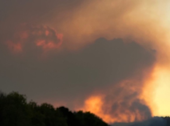
The Deep Fire is currently mapped at 4,114 acres and is 60% contained.
Yesterday’s gusty conditions did cause an increase in fire behavior, but again only in the steep slopes aligned with the wind on the northeast corner of the fire. There is a high probability that will continue today. Weather conditions are expected to trend drier and warmer, with gusty north winds moving into the fire area in the afternoon. There is a Fire Weather Warning issued for areas just to our south and west. While we are not included in that warning, we are likely to experience some higher winds.
With the southern area of the fire looking cold both on field observation and via infrared mapping, the priority today is to limit the fire’s northern spread. While the bulk of the activity in the northeastern end of the Deep Creek drainage is poised to run into high elevation rock, the backing into Little Salt Creek continues, and crews have been working their way north on the Stuart Fork Trial, preparing to turn east.
Crews pulled most of the equipment from around the structures in the private property including the Van Matre inholding and the Trinity Alps Resort, but are maintaining a presence, especially through today’s predicted weather. They also continue to walk the Stuart Fork Trail to ensure that no burning material has rolled off the hillside.
Residents and visitors are likely to see smoke interior to the fire for the foreseeable future.
WEATHER
Smoke from fires across the north state continues to push into the Trinity Lake/Weaverville issue. With predicted winds, that is likely to continue through today. However, a major change in conditions is anticipated for as early as late Thursday night as a strong system pushes into the area, bringing cooler, wetter conditions to the area. Clouds and showers will keep temperatures well below normal through Sunday with a good chance of wetting rain.
FOREST CLOSURES
There is a forest closure associated with the Deep Fire. For current information on forest closures, visit https://www.fs.usda.gov/stnf
EVACUATION UPDATES
For the latest evacuation information from the Trinity County Sheriff’s Department: https://www.facebook.com/people/Trinity-County-Sheriffs-Office/100064589806351/
For information on evacuation resources from the Trinity County Office of Emergency Services: https://www.trinitycounty.org/OES
To sign up for codeRED notifications: text “TrinityCA” to 99411.
Oregon Fire Evacuation Information August 29 2023
Related Incident: Oregon Fire
Publication Type: Announcement
Both Spokane and Pend Oreille Counties rescinded all evacuation designations for the Oregon Fire effective at 4 p.m. on Tuesday, August 29, 2023.
Tiger Island Fire Smoke Report 83023
Related Incident: Tiger Island Fire
Publication Type: News
Daily Smoke Report and outlook for the Tiger Island Fire.
Fire The fire is 31,342 acres. Increasing fire activity is expected today with limited fire growth. Large fuels continue to smolder and provide the potential for active fire behavior with hotter, drier and windier weather. The latest fire information for the fire is located on Inciweb at https://inciweb.nwcg.gov/incident-information/lalas-tiger-island-fire
Smoke Increasing smoke in localized areas of the fire due to hotter and drier weather. Expect some smoke on roads adjacent to the fire, especially in the Merryville area. If we have active fire behavior with fire progression, or new starts, there could be high levels of smoke for short durations in the vicinity of the fire. Winds will carry smoke toward the coast and could cause spikes of smoke to UNHEALTHY for SENSITIVE GROUPS levels in the Lake Charles area and the I-10 corridor. If you encounter smoke on roads, reduce speeds if visibility drops.
FOR MORE INFORMATION Conditions can change at any time. If you see smoke and smell smoke, you are breathing smoke. For near time air quality information see EPA's Fire and Smoke Map: https://fire.airnow.gov/
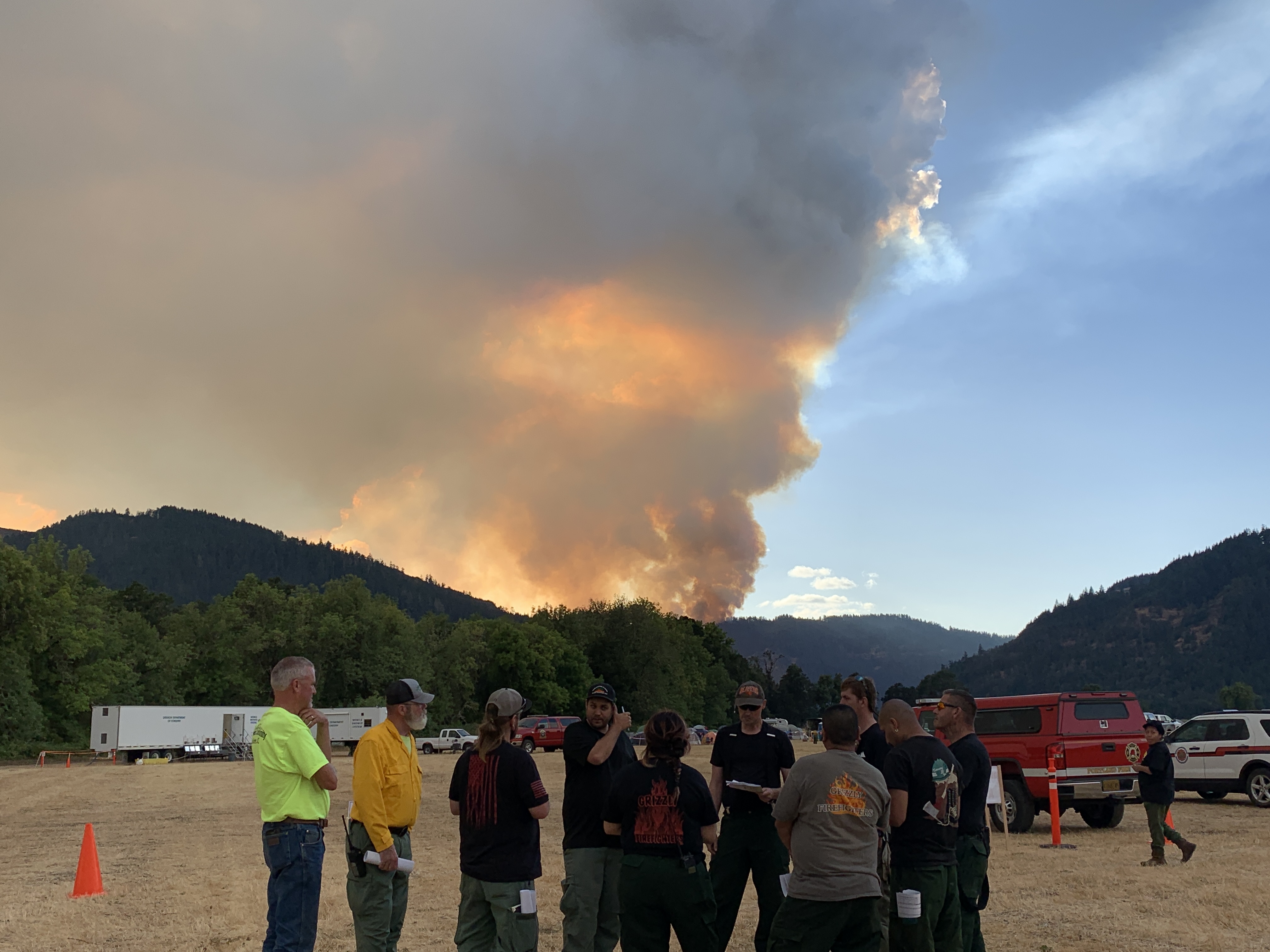
Tyee Ridge Complex Evening Update 082923
Related Incident: Tyee Ridge Complex
Publication Type: Announcement
Acreage: 2,899
Containment: 5%
Growing Air and Ground Resources Support Fire Response
Umpqua, Ore. – Resources continued to arrive on the Tyee Ridge Complex today with a total of 1093 personnel engaged. Aircraft assisted with water and retardant drops, supporting ground operations in areas of steep or inaccessible terrain. Two Very Large Air Tankers (VLATs) from Medford provided retardant drops on ridges on the Lighthouse 3 Fire. To the north, crews increased mopup on the Big Tom, Hardscrabble, Blue Hole, and Yellow Point Fires. Tactical firing operations also helped improve line on Big Tom. Moving these fires toward patrol status will aid the overall effort by allowing resources to focus on the more active fires to the south.
Fire behavior became very active in the afternoon on the Lighthouse and Cougar Creek Fires with spotting, slopovers, and uphill runs. Thermal belts, or pockets of warmer air over the fires, contributed to this activity. Oregon Department of Forestry wildland fire resources responded, including helicopters, single engine air tankers, heavy equipment, and hand crews. They built and reinforced line, and engaged in initial attack on spots and slopovers. Two Oregon State Fire Marshal task forces worked around structures, installing sprinkler kits at the Lighthouse Center and along Hubbard Creek Road.
Continued active fire behavior is likely overnight. Winds are expected to become gusty at 7 to 13 miles per hour. Night operations will focus on digging hand line, attacking any spot fires that cross lines, and addressing slopovers. Crews will continue tactical firing operations where possible to remove fuels between control lines and the fire’s edge.
All evacuation notices issued by the Douglas County Sheriff's Office remain unchanged. An estimated 183 persons have evacuated. The Red Cross shelter for evacuees is now located at The Way Church of Sutherlin located at 1352 E. Central Ave. in Sutherlin, OR. To shelter livestock, contact Douglas County Animal Control at 541-440-4471. Companion pets can be sheltered at Saving Grace Pet Adoption Center in Roseburg. To view the current evacuation information map, go to www.dcso.com/evacuations.
Oregon Department of Forestry Team 1
Joe Hessel, Incident Commander
OSFM Red Team, Ian Yocum, Incident Commander
Happy Camp Complex Incident Update August 29 2023 Evening
Related Incident: 2023 Happy Camp Complex Klamath NF
Publication Type: News
VIRTUAL PUBLIC MEETING: A virtual public meeting for the Happy Camp Complex will be held on Wednesday, August 30th, at 5:30 p.m. Fire personnel will provide an operational overview of the fire situation. The meeting will be live-streamed on Facebook (facebook.com/KlamathNF) and YouTube (youtube.com/@ciimt5). A Facebook account is not necessary to view the meeting.
WEST SIDE OVERVIEW (ACRES/CONTAINMENT): Elliot (9,915 acres, 21%), Malone (741 acres, 15%), Ufish (2,148 acres, 0%)
Strategic firing operations towards Elk Creek were conducted on the Malone Fire today. Tonight, firefighters will focus on holding and securing the fire’s south flank. Fire crews worked to maintain fire lines from last night's strategic firing operation on the Ufish Fire. If conditions permit, strategic firing will occur again tonight. The Elliot Fire increased in containment on the east flank along Highway 96, where crews continue to mop up and patrol the corridor. The west flank of the Elliot Fire remains active, and crews are working to establish indirect fire lines.
EAST SIDE OVERVIEW (ACRES/CONTAINMENT): Head (6,935 acres, 61%), Block (0.1 acres, 100%), Townsend (81 acres, 100%), Den (294 acres, 100%), Scott (1,886 acres, 70%), Lake (199, acres, 5%)
Containment increased today on the east side of the Head Fire. Better visibility allowed helicopters to make water drops over the fire, supporting firefighters on the ground. Firefighters will continue to focus on the north and south flanks of the Head fire to protect the community of Hamburg. The Lake Fire also increased in containment today, and crews will continue extinguishing interior pockets of heat tonight. The Scott Fire held within established containment lines, and firefighters will monitor the area. The Townsend Fire is 100 percent contained.
EVACUATIONS: View current Siskiyou County evacuation orders and warnings by visiting: community.zonehaven.com. Siskiyou County residents are encouraged to sign up for rapid emergency notifications using the CodeRED emergency alert system at: https://www.co.siskiyou.ca.us/emergencyservices/page/codered-emergency-alert
An evacuation center has been established at the Kahtishraam Wellness Center, 1403 Kahtishraam, Yreka, CA 95097. Call (530) 340-3539 if you have questions regarding the shelter.
ROAD CONDITIONS: State Route 96 is now open. One-way traffic control remains in place in several areas while crews work to repair damaged infrastructure, remove debris, and stabilize slopes. Delays at the locations with one-way traffic control could be up to an hour or more. The road will be closed to the public east of Seiad daily from 8:00 a.m. to 9:00 a.m. and from 6:30 p.m. to 8:00 p.m. to facilitate fire traffic. For the exact locations of where this work is taking place, please use quickmap.dot.ca.gov. County road closures will be listed on the Siskiyou County Public Works website: https://www.co.siskiyou.ca.us/publicworks/page/closures-and-delays.
FOREST CLOSURE: Two closure orders have been implemented: Happy Camp Complex Emergency Fire Closure, No.05-05-23-06; Happy Camp Complex Emergency Fire Closure, No. 05-05-23-07. Please refer to https://www.fs.usda.gov/alerts/klamath/alerts-notices to view the orders and maps.
TEMPORARY FLIGHT RESTRICTION (TFR): A TFR has been established over the fire area. Flight restrictions include the use of drones. The operation of drones under the TFR is prohibited.
PACIFIC CREST TRAIL: The Pacific Crest Trail is closed between the Shelly Fork Junction and Seiad as part of an area closure under Forest Order 05-05-23-07. It is suggested that northbound through-hikers exit the trail at Etna Summit and resume northward travel from Seiad.
AIR QUALITY: For information regarding smoke impacts and what you can do to protect yourself, visit: https://www.airnow.gov/
Trail and road closures in effect Please see below info for details
Related Incident: Eagle Point Fire
Publication Type: Closures
Due to wildfire activity the following closures are in effect until further notice:
- Elwha River Trail from Elkhorn to Low Divide
- Hayden Pass Trail
- Dosewallips River Trail from Dose Meadows to Hayden Pass
- Dodger Point Way Trail
- North Fork Quinault Trail from Elip Creek trail junction to Low Divide
- Skyline Trail from Elip Creek Trail junction to Low Divide
- Martin Park Trail
- Obstruction Point Road and Trailhead
Olympic National Park Wilderness Information Center (WIC) will be notifying backcountry permit holders who may be impacted by this closure. Any permit holders who plan to backpack in the above impacted areas should contact the WIC at 360-565-2992 or by emailing OLYM_WIC@nps.gov.
Settings - change map background and toggle additional layers
Filter - control incident types displayed on map.
Zoom to your location
Reset map zoom and position
Could not determine your location.
Show Legend
 Wildfire
 Prescribed Fire
 Burned Area
Response
Burned Area
Response Other
Other
Hurricane Fire
Unit Information
Incident Contacts
Happy Camp Complex Virtual Public Meeting August 30 2023 530 pm
Related Incident: 2023 Happy Camp Complex Klamath NF
Publication Type: Announcement
The Happy Camp Complex will hold the next virtual public meeting and fire operations update on Wednesday, August 30, 2023 at 5:30 pm.
Fire personnel will provide an operational overview of the fire situation.
The meeting will be live-streamed on both Facebook and YouTube.
- Facebook at https://facebook.com/KlamathNF
- YouTube at https://YouTube/@ciimt5
If you missed the meeting, view the video on YouTube
Umpqua National Forest Emergency Fire Closure 06150023475
Related Incident: 2023 Chilcoot Fire UNF2023 Ridge Fire UNF
Publication Type: Closures
Effective immediately, a forest closure has gone into effect today on portions of the Umpqua National Forest in response to fire activity in the area, and to protect public and wildland firefighter safety. This closure encompasses all of the Cottage Grove Ranger District, as well as portions of the North Umpqua and Diamond Lake Ranger Districts. A detailed closure map can be found at the bottom of this email. A number of recreation sites are included in this closure, but much of the forest remains open to the public. The following areas, while adjacent to the closure, remain open:
- North Umpqua Trail between FSR 34 and Masters Bridge on Highway 138
- Canton Creek Campground
- Steamboat Ballfield
- Gravel Bin Boat Ramp
- Island Campground
- Apple Creek Campground
- Horseshoe Bend Campground
- Eagle Rock Campground
- Boulder Flat Campground and Boat Ramp
- Toketee Lake Campground
- Forest Service Trail #1495, Toketee Falls trail and trailhead
This closure order can be found on our website and is in response to impacts from wildfires in the northern portion of the forest. There are currently twelve lightning-caused fires that firefighters have been working to extinguish or hold. Two fires are controlled, four are contained, and six are active. Here are the latest updates:
California Interagency Incident Management Team 12 (CAIIMT12) assumed command of the Chilcoot and the Ridge Fires as of 6:00 am, Monday, August 28, 2023. CAIIMT12. CA IMT12 is working unified command with Douglas Forest Protective Association (DFPA), and Oregon Department of Forestry (ODF) and are also coordinating closely with Bureau of Land Management (BLM) and local landowners to manage these fires.
- Chilcoot Fire – This fire is estimated at 921 acres. Firefighters have been constructing handline and using existing roads to build containment lines where possible. Crews are using portions of the 3806 Road to act as a barrier on the eastern perimeter of the fire. Yesterday dozer crews were able to work with Douglas Forest Protective Agency to build strong containment lines on the northwest corner of the fire. A Facebook page has been set-up for the most up-to-date information on the Chilcoot Fire.
- Ridge Fire – The fire is holding at approximately 250 acres and has shown minimal growth since its start. There was a small breach of the fire line into the Boulder Creek Wilderness, however crews are succeeding in using natural barriers as containment lines around it. The fire is holding at the 3810 Road on the south. Minimum Impact Suppression Tactics (MIST) are being utilized in wilderness areas. The higher elevation of the Ridge Fire has created greater visibility above the smoke layer and crews expect to be able to use aviation resources to the full extent possible. A Facebook page has been set-up for the most up-to-date information on the Ridge Fire.
- Dinner Fire – This fire is estimated around 200 acres and is located near Forest Service Road 17 to and Forest Service Road 1746, also known as Holland Meadows Road, A Type 2 Incident Management Team (PNW IMT12) has been ordered.
- Grizzly Fire – The fire estimated at 200 acres and is located near Grizzly Creek. Currently ODF resources are working this fire.
- Brice Creek Fire – Estimated at 169 acres this fire is near Brice Creek. Four engines and a hand crew are on scene.
- Wyatt Fire – Previously Brice Fire, is estimated at 30 acres and is located near Noonday Ridge.
- Timbered Knoll Fire – This fire is located west of Forest Service Road 5050, is less than an acre and is contained.
- Prather Fire – This 10-acre fire east of Prather Creek is contained.
- Snowpark Fire – This fire is less than one acre south of Cinnamon Butte and is controlled.
- Bohemia Fire – A lightning-caused start on private land that is less than one acre and controlled.
- Hill Fire – This fire is currently contained and under one acre.
- Watson Creek Fire – A less than one acre fire that is contained.
More information can be found at: https://www.wildwebe.net/?dc_name=ORRICC. Smoke has been present in Roseburg and surrounding communities in the area, air resource advisors work with communities to forecast smoke and notify the public through sites like AirNow.gov and https://outlooks.airfire.org/outlook.
Community Meeting Chilcoot and Ridge Fires August 30 at 7 pm
Related Incident: 2023 Ridge Fire UNF2023 Chilcoot Fire UNF
Publication Type: Announcement
Join California Interagency Incident Management Team 12 tomorrow, Wednesday 8/30 at 7pm for a community meeting across from Glide Revitalization, where fire staff will share information and answer questions about the Chilcoot Fire and Oregon Ridge Fire. Fire staff will discuss fire activity and suppression operations on the Umpqua National Forest's Chilcoot and Ridge Fires.
The public can join in person across from Glide Revitalization (125 Wild Thyme Lane, Glide, OR 97443) or virtually on the Chilcoot Fire Information page.
Do you have questions about the fire? Contact the U.S. Forest Service - Umpqua National Forest Supervisor's Office at (541) 957-3200 or message us here. We will post the daily update shortly.