
Smith River Complex South Update August 30 2023
Related Incident: Smith River Complex
Publication Type: News
Start date: Aug 15, 2023
Location: Six Rivers National Forest
Cause: Lightning
Acres: 75,775
Containment: 7%
Personnel: 3,035
Gasquet, Calif., August 30, 2023. Fire resources were prepared for increased fire activity due to the expected uptick in afternoon westerly winds. Although the winds did arrive with gusts up to 20 mph on the upper elevations, an increase in moisture helped limit overall fire activity. Firefighters spent the day using hose lays to secure containment lines north of Gasquet, near Pioneer Road, and along Highway 199 to the French Hill Road. These lines continue to hold and the threat of fire reaching Gasquet continues to decrease each day. Another focus has been to fall hazard trees and work hot areas along Highway 199 to expedite the opening of the critical road system.
Firefighters also focused efforts in the area where the Kelly fire and Coon fire are close to connecting near the 405 road. Several days ago, the Coon fire made a small run adjacent to Gordon Creek and challenged this line. Holding the fire on the west side of the 405 road was challenging due to stronger westerly winds, but firefighters have been successful thus far.
Winds have begun to shift to more of an offshore direction today and are expected to remain out of the northeast through tonight. This will bring a period of near critical fire weather conditions today through the evening hours, especially in the areas of the fire over 2,500’ elevation where the stronger winds are predicted. Firefighters will be on high alert today during these critical weather conditions in anticipation of increased fire activity. These adverse conditions will quickly moderate as conditions become more favorable by tomorrow morning. The potential for light rain increases by Thursday night, along with clouds and onshore flow as an upper-level Pacific Northwest trough enters the area and lingers into Saturday.
Evacuations
All evacuation orders are issued by the Del Norte County Sheriff's Office. If you are in the Del Norte County, area please sign up for their Community Alert System to receive emergency notifications. Evacuation levels as of August 27, 8:00 a.m., as follows:
Level 3 “Go Now”: Patrick Creek, Little Jones Creek, Copper Creek Drainage, Coon Creek/ 16n19 17n07, Washington Flat, Pioneer Road, Panther Flat Campground Area, all communities between Slant Bridge Road north to the Oregon Border along Highway 199, French Hill Road.
Level 2 “Be Set”: Low Divide, High Divide, Rowdy Creek, Big Flat/Rock Creek
Level 1 “Be Ready”: Hiouchi from Slant Bridge to the east end of North Bank Road
Closures
South Fork Road is open to residents only. Resident must provide proof of residency.
Rowdy Creek Road remains closed at the top of Low Divide.
Howland Hill Road (Residents Only)
County road 316, Shelly Creek,
County Road 315 Holiday Mine
County Road 311 Old Gasquet Toll Road
Forest Service Roads 16N19 and 17N07
U.S. Highway 199 is closed in Del Norte County from Slant Bridge Road to Oregon Mountain Road (PM 16 to 31) due to the fire activity. A hard closure is in place on U.S. 199 at the Agriculture Station near the Oregon border. For the latest road conditions please visit quickmap.dot.ca.gov
Effective Sunday, August 20, 2023, the Six Rivers National Forest has issued a forest-wide closure order. https://www.fs.usda.gov/detail/srnf/notices/?cid=FSEPRD1096395
The American Red Cross has a shelter at the Del Norte County Fairgrounds (421 US-101 N, Crescent City, CA 95531) for those displaced by evacuations. Red Cross disaster workers are partnering with local officials to help ensure evacuees receive necessities, including food, water, and shelter.
More Information
Smith River Complex Inciweb: inciweb.nwcg.gov/incident-information/casrf-smith-river-complex
Six River National Forest: https://www.facebook.com/SixRiversNF
Del Norte Office of Emergency Services: https://www.facebook.com/DelNorteOfficeOfEmergencyServices
Del Norte County Sheriff’s Office: https://www.facebook.com/DelNorteCountySheriffDepartment
Smith River Complex North: https://www.facebook.com/smithrivercomplexnorth
Rogue River-Siskiyou National Forest: https://www.facebook.com/R6RRSNF/
Josephine County Emergency Management: https://www.facebook.com/josephinecountyEM
For an interactive evacuation map please visit: https://rvem.org/.
Clear Lake Fire Final Daily Update August 28 2023
Related Incident:
Publication Type: News
Clear Lake Fire
News - 08/28/2023
Size: 771 acres
Containment: 100%
Start Date: August 28, 2023
Current Situation:
Crews from Texas A&M Forest Service have completed containment lines and mop-up operations. All state resources have been released and, pending any significant change in fire activity, this incident will no longer be updated.
South Fork Complex Update August 30 2023
Related Incident: South Fork Complex
Publication Type: News
People and Equipment: 850 personnel, crews, engines, dozers, water tenders
Current Situation:
3-9 Fire: 2,427 acres with 22% containment
Pilot Fire: 1,055 acres with 96% containment and air support
Pellitreau Fire: 3 acres with 100% containment
Sulphur Fire: 31 acres with 100% containment
45% overall containment for the Complex
3-9 Fire The northern division (Division O), has 100% hand line completed around the perimeter. Fire personnel continue to mop up and increase depth of the containment line. Yesterday, in the southern division (Division A), a 400-acre slop over crossed over the dozer line and contingency line as the fire was in alignment with the wind and topography. Dozers will continue to open up roads south of the fire perimeter. Aircraft continue supporting firefighting efforts with water and retardant drops to slow fire progression and allow crews an opportunity to go direct along the fire perimeter. Along the northwestern perimeter, crews continue to mop up and secure control lines down to and paralleling Pilot Creek. On the eastern portion of the fire (Division W), they continue to monitor and mop up spot fires with the assistance of helicopter water drops.
Pilot Fire Crews have successfully finished 100% containment line around the perimeter and continued to focus on mopping up and adding depth. Fire personnel will continue to secure and mop up the perimeter and improve contingency lines.
The Pellitreau Fire and the Sulfur Fire are 100% contained. Firefighters will continue to monitor and patrol to ensure fire remains within the containment lines.
Weather: Maximum temperatures are expected to be 60-65 ºF. Minimum relative humidities are expected to be 26-28%. North-northwest winds are expected to be 10-15 mph throughout the day with gusts of 30 mph.
Evacuation Warning: An Evacuation Warning has been issued for Zone HUM E 114 A, north of Henry Ridge and east of the Mad River. An Evacuation Warning for Zone HUM E 114 B, south of Henry Ridge, north and east of the Mad River. Please note: Zone HUM E 114 has been split into three zones A, B, and C. For more information go to humboldtsheriff.org/emergency. Or call 707-268-2500. All previous Evacuation Warnings surrounding the South Fork Complex remain in effect. Please continue to check the Trinity County Wildfire and Evacuation site for up-to-date status and locations: Trinity County Wildfire and Evacuation Map.
Forest Closure: There are new Forest Closure orders for the South Fork Complex Fire that have been posted on the Shasta-Trinity National Forest website home page and on the Six Rivers National Forest (click on Forest Closures). Please avoid the closed areas
Quartz Ridge and Bear Creek Fires Daily Update August 30 2023
Related Incident: Bear Creek Fire
Publication Type: News
August 30, 2023 Type 3 Team, Incident Commander: Nick Collard ICT3, Grif Cochran ICT3 (T)
Daily Update – 9:00 AM
Highlights: The Mosca (Piedra) Road (NFSR#631) reopened on Wednesday, August 30th. Additional road and trail closures remain in effect. Fire activity is expected to be minimal with smoldering, creeping, and backing where pockets of heat remain. Resources are available to respond quickly if conditions change.
Quartz Ridge Fire: 1,840 acres, increase of 7 acres | 76% of objectives achieved | 61 personnel assigned
Infrared mapping from aircraft showed scattered heat on the south side of the fire on the east side of Quartz Creek near the trail. Direct control lines are being utilized to suppress accessible parts of the fire and indirect control lines are providing confinement on remote areas that present high safety risks to firefighters.
Bear Creek Fire: 443 acres, no change in acreage | 82% of objectives achieved | 15 personnel assigned
Infrared mapping from aircraft showed isolated points of heat along the ridge between Bear Creek and Shaw Creek. Minimal fire behavior is expected, but more active fire behavior may produce smoke in interior areas of the fire as conditions continue to dry out. Fire spread is not expected as fuel moistures remain elevated.
Weather: Not much change to the forecast except a subtle increase in atmospheric moisture as the high pressure ridge begins to shift to the east ushering in moisture out of the southwest. There will be a better chance for isolated to scattered thunderstorms in the afternoon with gusty winds, lightning, and brief periods of heavy rain.
San Juan National Forest Temporary Area Closures: Closure orders are in effect and additional information can be found here. Roads and trails within area closures are Quartz Meadows Rd (NFSR#684), Quartz Ridge Trail (NFST#570), Quartz Creek Trail (NFST#571), Little Sand Trail (NFST #591), and Shaw Creek Trail (NFST#584).
Restrictions: Stage 1 Fire Restrictions are in place today for the San Juan National Forest. This restriction will be lifted starting tomorrow (Thursday). Additional information is available here.
Fire Information
Office Hours: 8:00 AM – 8:00 PM
Phone: 970-426-5370
Quartz Ridge Fire
Email: 2023.QuartzRidge@firenet.gov
InciWeb:
https://inciweb.nwcg.gov/incident-information/cosjf-quartz-ridge-fire
https://www.facebook.com/profile.php?id=100095556640621
Bear Creek Fire
Email: 2023.BearCreek@firenet.gov
Inciweb
https://inciweb.nwcg.gov/incident-information/cosjf-bear-creek-fire
https://www.facebook.com/profile.php?id=100095241777192
Quartz Ridge Fire Daily Update 08302023
Related Incident: Quartz Ridge Fire
Publication Type: News
August 30, 2023 Daily Update – 9:00 AM
Type 3 Team, Incident Commander: Nick Collard ICT3 Grif Cochran ICT3 (T)
Highlights: The Mosca (Piedra) Road (NFSR#631) reopened on Wednesday, August 30th. Additional road and trail closures remain in effect. Fire activity is expected to be minimal with smoldering, creeping, and backing where pockets of heat remain. Resources are available to respond quickly if conditions change.
Quartz Ridge Fire: 1,840 acres, increase of 7 acres | 76% of objectives achieved | 61 personnel assigned
Infrared mapping from aircraft showed scattered heat on the south side of the fire on the east side of Quartz Creek near the trail. Direct control lines are being utilized to suppress accessible parts of the fire and indirect control lines are providing confinement on remote areas that present high safety risks to firefighters.
Bear Creek Fire: 443 acres, no change in acreage | 82% of objectives achieved | 15 personnel assigned
Infrared mapping from aircraft showed isolated points of heat along the ridge between Bear Creek and Shaw Creek. Minimal fire behavior is expected, but more active fire behavior may produce smoke in interior areas of the fire as conditions continue to dry out. Fire spread is not expected as fuel moistures remain elevated.
Weather: Not much change to the forecast except a subtle increase in atmospheric moisture as the high pressure ridge begins to shift to the east ushering in moisture out of the southwest. There will be a better chance for isolated to scattered thunderstorms in the afternoon with gusty winds, lightning, and brief periods of heavy rain.
San Juan National Forest Temporary Area Closures: Closure orders are in effect and additional information can be found here. Roads and trails within area closures are Quartz Meadows Rd (NFSR#684), Quartz Ridge Trail (NFST#570), Quartz Creek Trail (NFST#571), Little Sand Trail (NFST #591), and Shaw Creek Trail (NFST#584).
Restrictions: Stage 1 Fire Restrictions are in place today for the San Juan National Forest. This restriction will be lifted starting tomorrow (Thursday). Additional information is available here.
Fire Information
Office Hours: 8:00 AM – 8:00 PM
Phone: 970-426-5370
Quartz Ridge Fire
Email: 2023.QuartzRidge@firenet.gov
InciWeb:
https://inciweb.nwcg.gov/incident-information/cosjf-quartz-ridge-fire
https://www.facebook.com/profile.php?id=100095556640621
Bear Creek Fire
Email: 2023.BearCreek@firenet.gov
Inciweb
https://inciweb.nwcg.gov/incident-information/cosjf-bear-creek-fire
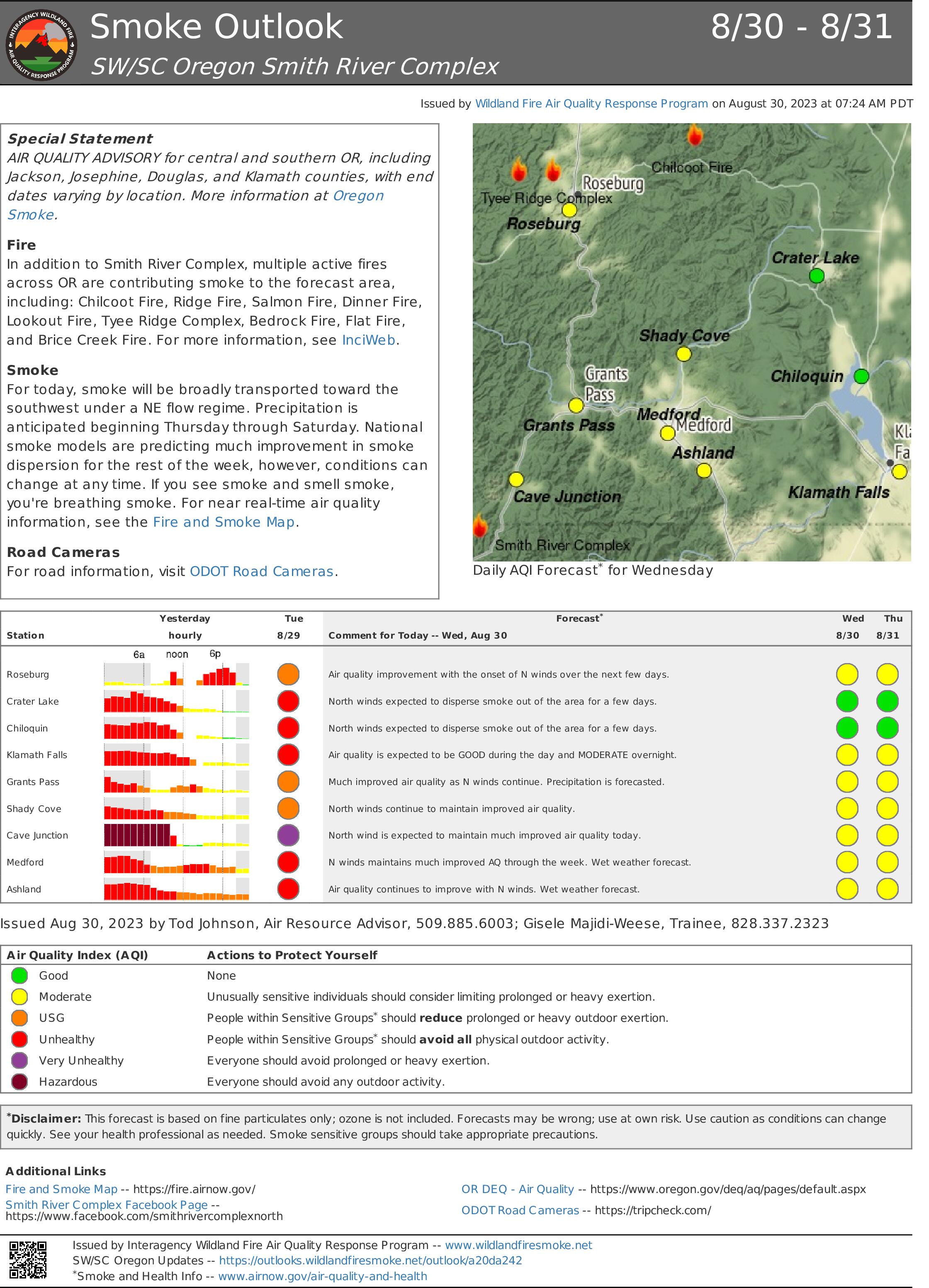
Smoke Outlook 830 831 Smith River Complex
Related Incident: Smith River Complex
Publication Type: News
Special Statement
AIR QUALITY ADVISORY for central and southern OR, including Jackson, Josephine, Douglas, and Klamath counties, with end dates varying by location. More information at Oregon Smoke.
Fire
In addition to Smith River Complex, multiple active fires across OR are contributing smoke to the forecast area, including: Chilcoot Fire, Ridge Fire, Salmon Fire, Dinner Fire, Lookout Fire, Tyee Ridge Complex, Bedrock Fire, Flat Fire, and Brice Creek Fire. For more information, see InciWeb.
Smoke
For today, smoke will be broadly transported toward the southwest under a NE flow regime. Precipitation is anticipated beginning Thursday through Saturday. National smoke models are predicting much improvement in smoke dispersion for the rest of the week, however, conditions can change at any time. If you see smoke and smell smoke, you're breathing smoke. For near real-time air quality information, see the Fire and Smoke Map.
Road Cameras
For road information, visit ODOT Road Cameras.
Loop Fire Final Update Wednesday August 30 2023 at 1000 am
Related Incident:
Publication Type: News
Size: 2230
Containment: 100%
Start Date: August 18, 2023
Cause: Lightning
This is the final update for the Loop Fire as the Texas A&M Forest Service transitioned command of the fire to local fire departments this morning.
At approximately 4:30 p.m. on Aug. 18, Texas A&M Forest Service received a request for assistance on a fire burning approximately 10 miles south of Abilene, in Taylor County, Texas.
Yesterday: Engine crews and sawyers continued to patrol and engaged in mop up operations when necessary. Fire managers reported all threats to the containment line had been mitigated at the end of shift last evening.
Today: The fire will be monitored by local fire departments and Clay County Emergency Management.
Evacuations: There are no evacuations in place at this time, but citizens are encouraged to refer to the Clay County Sheriff's Office's Facebook page for more information.
Damages/Injuries: None reported
Closures/Restrictions:
Clay County implemented a county-wide burn ban for Clay County effective immediately July 26. Please follow the link below for more information.
East Fork Fire August 30 2023 Update
Related Incident: East Fork Fire
Publication Type: News
NORTHERN ROCKIES TEAM 6
INCIDENT COMMANDER: Paul Roose
East Fork Fire
Kootenai National Forest/Flathead National Forest
Fire Information 406-285-8634 Eastforkfireinfo@gmail.com
August 30, 2023
Location: 12 miles south of Trego, MT
Start Date: 7/30/2023
Cause: Lightning
Size: 5,162 acres
Containment: 20%
Total Personnel: 662
Engines: 15
Hand Crews: 12
Helicopters: 2
Yesterday’s Events: Tuesday's strategy was tailored to the final day of hot, dry conditions in advance of an incoming cold front. Crews performed successful back burning operations on the north and south side of the fire to remove fuels between the fire and the mechanically created fireline. Ground crews spent time mopping up these areas before winds were anticipated to hit the fire at around 6pm. (as seen in picture) These back burns along with some continued creeping in the interior of the fire are what has largely contributed to the increase in acreage.There were a few areas that had increased fire activity and fire fighters observed single trees torching. This fire behavior was anticipated and crews were prepared. The line of thunderstorms on the leading edge of the cold front did not materialize and evening wind gusts were more moderate on the fire. Heavy rains moved over the fire around midnight.
Plans for Today: With the wet weather, Wednesday's approach will focus on safety, rehabilitation and repair. All crews have been advised to use extra caution in the inclement weather and take into account falling tree hazards. The weather will be monitored closely and firefighters will look for breaks in the rain to remove downed trees and work on the line. This is another season slowing event and it will likely be 5-7 days before we see any real fire activity once the weather gets hot and dry again.
Weather Update: Up to 1/2 inch of rain fell overnight and the incident meteorologist anticipates another ½ to 1 inch of rain throughout the day. We will see showers, possible afternoon wind gusts and cooler temperatures. The temperature should be steady around 50 degrees. The low pressure system should hover in the area for at least the day.
Evacuations: Some communities remain in a Pre-Evacuation Warning. Residents may return to their homes under a Pre-Evacuation Warning, but may need to leave again on short notice. For more information, go to the Lincoln County and Flathead County Sheriff’s Department Facebook pages.
Public Meetings: No public meetings are scheduled at this time, though fire personnel are available to address questions or concerns via the email address and telephone number noted above.
Fire information Officers Available in the Community Wednesday
Related Incident: Camp Creek Fire
Publication Type: Announcement
No community meeting is scheduled for this evening. However, fire information offers will be stationed at two locations today and available for questions:
- Sandy Fire Station #71 from 12:00 - 2:00 p.m.
- Hoodland Thriftway from 2:00 - 4:00 p.m.
Tiger Island Fire Daily Report 83023
Related Incident: Tiger Island Fire
Publication Type: News
Louisiana Statewide Burn Ban: The state of Louisiana has declared a statewide burn ban to include any open flame outdoors. The message from the State Fire Marshal’s Office is “don’t burn anything” until further notice. Citations and arrests ARE happening across this state in partnership with local and state law enforcement agencies.
Tiger Island Fire: The Tiger Island Fire was first reported on Tuesday, August 22nd. The fire is located east of Merryville, south of Hwy 190, SW of DeRidder and North of Singer. The fire is burning in pine plantations of multiple ages. Access to portions of the fire area is difficult. Fuel loads in these pine plantations are high. Heavy residual fuels because of Hurricane Laura in 2020 exist and contribute to extreme fire behavior.
Acreage: 31,342 acres Containment: 50%
Personnel and Equipment: 275 total personnel; 7 Helicopters, 13 Type-6 Engines, 2 Type-2 Tractor Plow Units, 20 Dozers, and 4 Ambulances. Additional support is being provided by the National Guard, Parish authorities, the Governor’s Office of Homeland Security and Emergency Preparedness, the Louisiana State Fire Marshal Team, Beauregard Sherriff’s office, and the Office of Emergency Preparedness. The National Guard is supporting with Black Hawk helicopters and 16 dozers and the fire response is using Large Air Tankers, Scoopers, and Air Attacks from Texas.
Operations: Yesterday’s operations reported fire activity near Shin Road. Ground crews, with support from helicopters, were able to ensure that there was no fire progression in this area. On the western perimeter of the fire, there was active burning interior, with no threat to containment in that area. Along the north, northeastern and eastern perimeters, crews and equipment continued to connect containment line as direct to the fire perimeter as possible, while improving lines for engines to access to begin mopping up interior heat. Night operations have shifted to a swing shift to put additional crews on the line during the afternoon when fire activity may increase.
Weather and Fire Behavior: A Red Flag Warning is in effect from 10:00 a.m. until 8:00 p.m. for hot, very dry conditions with wind gusts up to 25 mph. Temperatures will continue to be in the mid to high 90s, and humidity levels will drop into the teens, which is unheard of in Louisiana in August. Extreme and Exceptional drought conditions remain. Fuels remain critically dry and, combined with gusty winds, have the potential to produce extreme fire behavior.
Air Quality: There will be increasing smoke in localized areas of the fire due to hotter and drier weather. Expect some smoke on roads adjacent to the fire, especially in the Merryville area. If we have active fire behavior with fire progression, or new starts, there could be high levels of smoke for short durations in the vicinity of the fire. Winds will carry smoke toward the coast and could cause spikes of smoke to UNHEALTHY for SENSITIVE GROUPS levels in the Lake Charles area and the I-10 corridor. If you encounter smoke on roads, reduce speeds if visibility drops. Conditions can change at any time. If you see smoke and smell smoke, you are breathing smoke. For near time air quality information see EPA's Fire and Smoke Map: https://fire.airnow.gov/
Temporary Flight Restriction: A Temporary Flight Restriction (TFR) remains in place over the fire area; information is at Federal Aviation Administration website. This is necessary to protect aerial operations. If there are intrusions into the Temporary Flight Restrictions, we must ground all aircraft.
Evacuations: Updates on evacuations and shelters can be found on the Beauregard Parish Sheriff’s Office Facebook Page at https://www.facebook.com/beauregardsheriff.