
Gibbs Forest Fire Daily Update August 31 2023
Related Incident:
Publication Type: News
Gibbs Forest Fire Daily Update
August 31, 2023
10:00 am
Size: 300 acres
Containment: 95%
Start Date: August 29, 2023
Cause: Under Investigation
Texas A&M Forest Service received a request for assistance from Walker County for a fire at State Highway 30 and Pool Road 12.5 miles west of Huntsville, Texas on August 29, at 3:30 pm.
In coordination with local fire departments, crews from Texas A&M Forest Service and several aviation resources were engaged in mop-up operation efforts yesterday. Crews identified spots outside the containment yesterday morning causing the containment percentage to drop. Two Type 1 helicopters and up to 4 super-scoopers took action to put out those spots under the coordination of Air Attack and ground resources. Dozers and 1 motor grader continued to improve and widen containment lines up to 3 dozer blade widths wide.
State crews are back on scene today containing multiple pieces of heavy equipment and engines to improve existing containment lines and patrol the area for spot fires.
Weather:
Hot and dry conditions will persist. A Red Flag Warning is in effect for the area and relative humidity values will average 20-25%. Winds are expected to be around 5 mph from the east before rotating to the northeast this afternoon. Current conditions coupled with extremely dry fuel and hot temperatures make it important to be extremely cautious with - or avoid entirely - the use of fire or equipment that can cause sparks on dry vegetation. Burn bans are in effect for the entirety of southeast Texas.
Evacuations:
There are no evacuations at this time.
Closures:
There are no road closures at this time.
Damages and Injuries:
Currently, there have been no reports of injuries from the public or first responders. No structure or critical infrastructure have been lost.
Bear Creek Daily Update 08312023
Related Incident: Bear Creek Fire
Publication Type: News
August 31, 2023
Type 3 Team, Incident Commander: Nick Collard ICT3, Grif Cochran ICT3 (T)
Daily Update – 9:00 AM
Highlights: San Juan National Forest has lifted Stage 1 Fire Restrictions effective today. Fire activity is expected to be minimal with smoldering, creeping, and backing where pockets of heat remain. Scattered areas of heat may produce more smoke today as conditions continue to dry out. Resources are available to respond quickly if conditions change.
Quartz Ridge Fire: 1,840 acres, no change in acreage | 76% of objectives achieved | 56 personnel assigned
Crews continue to work on building a shaded fuel break along Quartz Meadows Rd (NFSR#684). Direct control lines are being utilized to suppress accessible parts of the fire and indirect control lines are providing confinement on remote areas that present high safety risks to firefighters.
Bear Creek Fire: 443 acres, no change in acreage | 82% of objectives achieved | 15 personnel assigned
Minimal fire behavior is expected, but more active fire behavior may produce smoke as conditions continue to dry out. Fire spread is not expected as fuel moistures remain elevated.
Weather: Thursday is looking drier with breezy conditions with increasing moisture holding off until late Friday into the weekend. Friday’s forecast continues to call for scattered showers and thunderstorms. Gusty and erratic winds can be expected near thunderstorms.
San Juan National Forest Temporary Closures: Closure orders are in effect and additional information can be found here. Roads and trails within area closures are Quartz Meadows Rd (NFSR#684), Quartz Ridge Trail (NFST#570), Quartz Creek Trail (NFST#571), Little Sand Trail (NFST #591), and Shaw Creek Trail (NFST#584).
Pagosa Springs, Cloman Park: Cloman Park is no longer being used as a camp for fire crews and is available for public use as determined by the city.
Fire Information
Office Hours: 8:00 AM – 8:00 PM
Phone: 970-426-5370
Quartz Ridge Fire
Email: 2023.QuartzRidge@firenet.gov
InciWeb:
https://inciweb.nwcg.gov/incident-information/cosjf-quartz-ridge-fire
https://www.facebook.com/profile.php?id=100095556640621
Bear Creek Fire
Email: 2023.BearCreek@firenet.gov
Inciweb
https://inciweb.nwcg.gov/incident-information/cosjf-bear-creek-fire
https://www.facebook.com/profile.php?id=100095241777192
####
31 de agosto 2023 Informacin al da para el Incendio Flat y Incendio Anvil
Related Incident: Flat Fire
Publication Type: News
Informe matutino del Incendio Flat
Extensión: 34,242 acres
Origen: 2 millas Sureste de Agness, OR
Contencion: 58%
Fecha de Inicio: `15 de Julio, 2023
Personal: 330
Recursos: 5 escuadrillas de bomberos l 3 helicópteros l 8 camiones de bomberos l 3 buldóceres l 9 cisternas l 4 máquinas masticadoras
El Equipo 3 de Gestión de Incidentes de las Rocosas del Norte asumirá el mando de los incendios de Flat y Anvil a partir de las 7:00 a.m. del viernes 1 de septiembre de 2023, de manos del Equipo 3 de Gestión de Incidentes del Área Suroeste (SWAIMT-T3). El SWAIMT-T3 proporcionó el mando de los recursos asignados durante 14 días mientras se coordinaba con el condado, la ciudad y varias otras agencias, incluido el Bosque Nacional Rogue River-Siskiyou.
Actividad del incendio: Las cuadrillas y los aviones continúan patrullando y vigilando el borde del incendio, completando los trabajos de reparación de senderos y trabajando con los propietarios privados en cualquier reparación necesaria debido a las actividades de supresión. Astillando combustibles continúa a lo largo de la carretera forestal 109 y se completará durante el fin de semana. El incendio no ha crecido, pero el humo será visible a medida que se consuman los combustibles interiores. Los recursos de ataque inicial están listos para ayudar al bosque si es necesario.
Informe matutino del Incendio Anvil:
Extensión: 51 acres
Origen: 8 millas Este de Port Orford, OR
Contención: 0%
Fecha de Inicio: 25 agosto, 2023
Personal: 97
Recursos: 3 escuadrillas de bomberos l 6 helicópteros l12 rapeladores l 3 camiones de bomberos l 1
Actividad del fuego: El Anvil Fire estaba activo ayer con el crecimiento hacia el oeste como el fuego se trasladó hasta drenajes en Anvil Mountain. Los aviones utilizaron agua y retardante a lo largo de las crestas para frenar su progresión y ayudar a los bomberos en tierra. El humo era muy visible ayer y seguirá siéndolo hoy, aunque las condiciones meteorológicas cambiarán y el aumento de la humedad, la bajada de las temperaturas y la posibilidad de humedad ralentizarán la progresión del incendio. El fuego está ardiendo en el Grassy Knob Wilderness en pendientes pronunciadas y terreno difícil con acceso limitado. Los aviones seguirán apoyando las labores de extinción y controlando la actividad.
Tiempo: Temperaturas por debajo de lo normal y una mayor humedad se espera que el jueves junto con el aumento de las posibilidades de lluvia. Los chubascos persistirán en la zona el viernes y el sábado, aunque las posibilidades de lluvia sobre el Incendio Anvil serán más limitadas. La humedad se mantendrá elevada durante el fin de semana.
Humo: El humo que permanece en la zona se está desplazando hacia el norte desde el Complejo Smith River y se está asentando en algunas comunidades cercanas, como Brookings. La perspectiva de humo para el Complejo Smith River está disponible en:https://outlooks.airfire.org/outlook/es/a20da242
Cierres: U.S. Highway 199 ha sido cerrada al norte de Gasquet debido a los incendios en el Six River National Forest, por favor, utilice U.S. Route 101 a SR 42 para todos los viajes hacia y desde el Valle Rogue. El Servicio Forestal y las carreteras BLM no deben utilizarse como rutas alternativas debido a la actividad del fuego emergente. El Bosque Nacional Rogue River-Siskiyou (RRSNF) ha emitido una orden de cierre de la zona del incendio que incluye senderos, carreteras y una parte del río Illinois.
Visite Rogue River-Siskiyou National Forest - Alerts & Notices (usda.gov) para más información.
Evacuaciones: Como recordatorio, esté atento al peligro en la zona. Manténgase informado: Suscríbase a las alertas de emergencia de su condado. Consulte el sitio web de gestión de emergencias del condado y siga a los servicios de emergencia locales en las redes sociales para obtener actualizaciones (condado, oficina del sheriff, agencias de bomberos). Nivel 1 "Prepárese" estado de evacuación en su lugar para las áreas en las proximidades de la Flat Fire. Enlace a más información: https://www.co.curry.or.us/government/county_sheriff/index.php
Restricciones: El peligro de incendio es actualmente extremo; la RRSNF está implementando Restricciones de Uso Público de Nivel 3 (PUR). El RRSF, Medford BLM y ODF han implementado PUR de nivel 3 en la sección salvaje del río Rogue. Para más información: Bosque Nacional Rogue River-Siskiyou - Noticias y eventos (usda.gov)
2023 SRF Lightning Complex and Redwood Lightning Complex Update 8312023
Related Incident: 2023 SRF Lightning Complex and Redwood Lightning Complex
Publication Type: News
2023 Six Rivers National Forest Lightning Complex and Redwood Lightning Complex
August 31, 2023 – California Incident Management Team 2 is in command of the Six Rivers National Forest (SRF) 2023 Lightning Complex and Redwood Lightning Complex, which is now comprised of 20 fires. Total acreage is estimated at 16481.2 acres with containment at 20%.
Redwood National and State Parks Area
Lost – 55% contained. 722 acres. Crews continue full suppression tactics on the fire that is burning in the Lost Man watershed. CAL FIRE and Green Diamond Resource Company are collaborating in suppression efforts. Most of the fire is in previously logged, second growth forest. Crews have held the fire on Holter Ridge. Mop up has begun on the east side of the fire along Holter Ridge.
Bridge Ridge – 100% contained. 17-acres burning near the Devil Fire. Containment lines have been established around the perimeter and crews are increasing the depth of the lines.
Devil – 100% contained. 12.4 acres. In patrol status.
Glen – 100% contained. 0.1 acre. In patrol status.
Hoopa Area
Lone Pine – 90% contained. 1,684 acres. Crews have almost completed removing unused hose line.
Orleans Area
Pearch - East of Orleans is estimated at 3,959 acres. Aerial controlled firing operations utilizing an Unmanned Aerial System (UAS) began yesterday and will continue over the next several days to increase lines north from DP 14 to DP11. Type 1 Structure Protection crews are working 24-hour shifts. Hose line and sprinklers have been deployed around values at risk. Structure Assessment Teams have been assessing structures for structure protection in the Somes Bar and Butler Creek areas.
The following fires are contained and in patrol status: Creek – 8 acres, Flat – 2.4 acres, Iron – 20 acres, Blue Creek - 0.1-acre, Big Foot - 0.8 acres.
The following fires are unstaffed due to difficult terrain and Firefighter safety: Monument – 2 acres, Hancock – 1,554 acres, Merrill Mountain – 2 acres, Blue Creek 2 – 2,608 acres, Marlow – 1,433 acres, Let er-Buck - 67 acres. Copper – 272 acres.
Pearch Fire Evacuation Warning:
Orleans Area: Zone HUM-E009 (Southeast of the Klamath River in Orleans) Zone HUM-E008-B (Community of Orleans, west of Klamath River. East of Crawford Creek, including Orleans proper). Hwy 96 and Red Cap Road along the east bank of Klamath River, south from Salmon River, east to Orleans Mountain. Approximately 243 residents live in these 2 zones.
Somes Bar Area: Zone SIS-1701: NORTH of Monte Creek Road, SOUTH OF Camp Three Road, EAST OF Camp Three Road, WEST OF Wooley Creek Trailhead. Anyone in these areas should be prepared for potential evacuations, including personal supplies and overnight accommodations. Be ready to go at a moment's notice.
NEW EVACUATION WARNING: Siskiyou County has issued Evacuation Warnings for Zones SIS-1402, SIS-1515, and SIS-1518
Mosquito - Near the Bluff Creek area north of Mosquito Lake is estimated at 2,262 acres. The fire remains north of Forest Road 11N19 and west of Forest Road 12N12 (Cedar Camp Road). Containment lines along the 12N12 Road have held. Crews continue constructing containment lines.
Bluff #1 – 1,855 acres with minimal movement. Firing operations have been utilized to assist with line construction along the 11N16 Road. Crews are constructing indirect line and conducting mop up.
Weather – An on-shore system is expected late this afternoon. The system will bring cooler temperatures, higher RH recovery, and a slight chance of rain.
Six Rivers National Forest Closures
Area and campground closures are in effect on Six Rivers National Forest. A new Closure Order was issued for the Orleans Ranger District and a portion of the Lower Trinity Ranger District. They can be found at: https://www.fs.usda.gov/detail/srnf/notices/?cid=FSEPRD1096395.
Redwood National Park and State Parks Closures
There are multiple closures in the parks due to several fires, including closures in the Lost Man area. For a full list of closures and impacts, please visit www.nps.gov/redw/planyourvisit/conditions.htm
Alert Notifications
ZoneHaven/Genasys for map and zone identification: https://protect.genasys.com
Humboldt County Residents Register for Humboldt Alert Notification: www.humboldt.gov/alerts
Siskiyou County Resident Register at Code Red Alert Notification: https://public.coderedweb.com/CNE/en-US/6F327CCDFFFD
Redwood National and State Parks Information Hotline
Phone: 707-464-6101
https://www.nps.gov/redw/planyourvisit/conditions.htm
2023 SRF Lightning Complex Fire Information
Phone: 530-536-0767 Email: 2023.lightningcomplex@firenet.gov Hoopa Information Hotline Phone: 530-618-2995 Email: serene.oes@gmail.com
Visit this link to access all resources listed on this update: www.linktr.ee/srffirepio
CALIFORNIA INTERAGENCY INCIDENT MANAGEMENT TEAM 2 will be transitioning with ROCKY MOUNTAIN COMPLEX INCIDENT MANAGEMENT TEAM 1 on Saturday, September 2, 2023
Flat Fire and Anvil Fire Morning Update 08312023
Related Incident: Flat Fire
Publication Type: News
Flat Fire
Size: 34,242 acres
Start Date: July 15, 2023
Point of origin: 2 miles southeast of Agness, OR
Containment: 58%
Total personnel: 330
Resources: 5 crews l 3 helicopters l 8 engines l 3 bulldozers l 9 water tenders l 4 masticators
The Northern Rockies Incident Management Team - Team 3 will assume command of the Flat and Anvil Fires as of 7:00 am, Friday September 1, 2023, from the Southwest Area Incident Management Team 3 (SWAIMT-T3). The SWAIMT-T3 provided command for the resources assigned for 14 days while coordinating with county, city and various other agencies including the Rogue River-Siskiyou National Forest.
Fire Activity: Crews and aircraft continue to patrol and monitor the fire’s edge, complete trail repair work and work with private landowners on any repairs needed due to suppression activities. Chipping of fuels continues along Forest Road 109 and will be completed over the weekend. The fire has not grown, but smoke will be visible as interiors fuels consume. Initial Attack resources are staged and ready to assist the forest if needed.
Anvil Fire Morning Update
Size: 51 acres
Start Date: August 25, 2023
Point of origin: 8 miles east of Port Orford, OR
Containment: 0%
Total personnel: 92
Resources: 3 crews l 6 helicopters l 12 rappelers l 3 engine l 1 bulldozer
Fire Activity: The Anvil Fire was active yesterday with growth to the west as the fire moved up into drainages on Anvil Mountain. Aircraft used water and retardant along ridges to slow its progression and assist firefighters on the ground. Smoke was very visible yesterday and will continue today, however weather conditions will be changing and higher humidity, lower temperatures and the possibility of moisture will slow the fires progression. The fire is burning in the Grassy Knob Wilderness on steep slopes and difficult terrain with limited access. Aircraft will continue to support fire suppression work and monitor activity.
Weather: Below normal temperatures and higher humidity is expected on Thursday along with increased chances of rain. Showers will linger in the area Friday and Saturday, although rain chances over the Anvil will be more limited. Humidity will remain elevated through the weekend.
Smoke: Smoke lingering within the area is moving north from the Smith River Complex and settling within some nearby communities, like Brookings. The smoke outlook for the Smith River Complex is available at: https://outlooks.airfire.org/outlook/en/a20da242
Closures: U.S. Highway 199 has been closed north of Gasquet due to fires on the Six River National Forest, please use U.S. Route 101 to SR 42 for all travel to and from the Rogue Valley. Forest Service and BLM roads should not be used as alternate routes due to emerging fire activity. The Rogue River-Siskiyou National Forest (RRSNF) has issued a closure order for the fire area including trails, roads, and a portion of the Illinois River. Visit Rogue River-Siskiyou National Forest - Alerts & Notices (usda.gov) for more information.
Evacuations: As a reminder, be aware of danger in the area. Stay informed: Sign up for emergency alerts with your county. Check the county emergency management website and follow local emergency services on social media for updates (county, sheriff’s office, fire agencies). Level 1 “Get Ready” evacuation status in place for areas in the vicinity of the Flat Fire. Link to more information: https://www.co.curry.or.us/government/county_sheriff/index.php
Restrictions: Fire danger is currently extreme; the RRSNF is implementing Level 3 Public Use Restrictions (PUR). Level 3 PURs on the Wild Section of the Rogue River have been implemented by the RRSF, Medford BLM and ODF. More information: Rogue River-Siskiyou National Forest - News & Events (usda.gov)
Quartz Ridge and Bear Creek Fires Daily Update August 31 2023
Related Incident: Quartz Ridge Fire
Publication Type: News
August 31, 2023
Type 3 Team, Incident Commander: Nick Collard ICT3, Grif Cochran ICT3 (T)
Daily Update – 9:00 AM
Highlights: San Juan National Forest has lifted Stage 1 Fire Restrictions effective today. Fire activity is expected to be minimal with smoldering, creeping, and backing where pockets of heat remain. Scattered areas of heat may produce more smoke today as conditions continue to dry out. Resources are available to respond quickly if conditions change.
Quartz Ridge Fire: 1,840 acres, no change in acreage | 76% of objectives achieved | 56 personnel assigned
Crews continue to work on building a shaded fuel break along Quartz Meadows Rd (NFSR#684). Direct control lines are being utilized to suppress accessible parts of the fire and indirect control lines are providing confinement on remote areas that present high safety risks to firefighters.
Bear Creek Fire: 443 acres, no change in acreage | 82% of objectives achieved | 15 personnel assigned
Minimal fire behavior is expected, but more active fire behavior may produce smoke as conditions continue to dry out. Fire spread is not expected as fuel moistures remain elevated.
Weather: Thursday is looking drier with breezy conditions with increasing moisture holding off until late Friday into the weekend. Friday’s forecast continues to call for scattered showers and thunderstorms. Gusty and erratic winds can be expected near thunderstorms.
San Juan National Forest Temporary Closures: Closure orders are in effect and additional information can be found here. Roads and trails within area closures are Quartz Meadows Rd (NFSR#684), Quartz Ridge Trail (NFST#570), Quartz Creek Trail (NFST#571), Little Sand Trail (NFST #591), and Shaw Creek Trail (NFST#584).
Pagosa Springs, Cloman Park: Cloman Park is no longer being used as a camp for fire crews and is available for public use as determined by the city.
Fire Information
Office Hours: 8:00 AM – 8:00 PM
Phone: 970-426-5370
Quartz Ridge Fire
Email: 2023.QuartzRidge@firenet.gov
InciWeb:
https://inciweb.nwcg.gov/incident-information/cosjf-quartz-ridge-fire
https://www.facebook.com/profile.php?id=100095556640621
Bear Creek Fire
Email: 2023.BearCreek@firenet.gov
Inciweb
https://inciweb.nwcg.gov/incident-information/cosjf-bear-creek-fire
https://www.facebook.com/profile.php?id=100095241777192
East Fork Fire August 31 2023 Update
Related Incident: East Fork Fire
Publication Type: News
NORTHERN ROCKIES TEAM 6
INCIDENT COMMANDER: Paul Roose
East Fork Fire
Kootenai National Forest/Flathead National Forest
Fire Information 406-285-8634 Eastforkfireinfo@gmail.com
August 31, 2023
Location: 12 miles south of Trego, MT
Start Date: 7/30/2023
Cause: Lightning
Size: 5,162 acres
Containment: 20%
Total Personnel: 662
Engines: 15
Hand Crews: 14
Helicopters: 2
Yesterday’s Events: Steady rain on Wednesday restricted fire suppression work on the East Fork Fire. Crews were limited to patrolling roads in the fire area for possible hot spots and trees that may have fallen across the fireline and/or access roads. The rain event was of sufficient duration and amount that fire behavior will be greatly reduced. According to Fire Behavior Analyst Eric Tremble, fuels have now become so moist that active fire is not likely for at least the next five days.
Plans for Today: Crews are facing challenges today such as slippery, wet roads and weakened, dangerous trees. As firefighters are able, they will construct fireline close to burned areas and remove unstable trees. Care will continue to be taken to protect roads and streams, which may be vulnerable to damage from recent rains.
Northern Rockies Team 5 will be taking command of the fire tomorrow morning at 6:00am. Team 6 has appreciated the warm welcome of the communities near the East Fork Fire and look forward to continuing the friendships we have formed with you.
Weather Update: An estimated 2” of precipitation fell on the fire area during the last 24 hours. Today’s forecast calls for cloudy skies and light winds with high temperatures in the low to mid 60’s. Relative humidity will stay fairly high, dropping only to 45 to 50%.
Evacuations: Flathead County Sheriff Brian Heino, in coordination with Team 6, lifted the recent pre-evacuation order on Wednesday because “the imminent risk of danger to life and properties in the vicinity of the East Fork Fire has diminished.” For more information, go to the Lincoln County and Flathead County Sheriff’s Department Facebook pages.
Public Meetings: No public meetings are scheduled at this time, though fire personnel are available to address questions or concerns via the email address and telephone number noted above.
To view today's operations video, go to https://youtu.be/644dpOGMGkY
Deep Fire Update August 31 2023
Related Incident: Deep Fire
Publication Type: News
CURRENT SITUATION
The Deep Fire is currently mapped at 4,186 acres and is 60% contained.
California Interagency Incident Management Team 10 will be transferring command of the Deep Fire to Nevada Team 5 tomorrow morning at 6:00 a.m.
A change in the weather is anticipated this afternoon, and gusty, erratic winds could enter the fire area in advance of a strong storm system. With lower humidity recovery overnight, fire behavior could temporarily increase this morning before the anticipated precipitation.
The fire continued to be active yesterday in the Deep Creek drainage on its northeastern edge, making an approximately 50-acre run in contiguous vegetation upslope, but did hold on the top of the ridge. These small runs are hitting high elevation rock and have little potential to spread.
In Little Salt Creek, fire continues to back into the drainage, and aircraft worked yesterday to slow momentum. Crews will work to build line across the northern edge of the fire, where safe, to prevent northern spread. Residual heat was also observed on the southwestern edge of Little Deep Creek along the Stuart Fork Trail and on the southeastern edge of the fire south of Sunday Creek. Helicopters worked both those areas yesterday, supporting firefighters who are on site to extinguish and contain those spots. They will continue that today.
WEATHER
A strong storm system is expected to move into the area late afternoon into evening tonight, bringing the potential for considerable rainfall and gusty winds. There is a possibility of heavy rain, which could impact the fire area. Firefighters will be receiving regular weather updates to ensure their safety on the line.
FOREST CLOSURES
There is a forest closure associated with the Deep Fire. For current information on forest closures, visit https://www.fs.usda.gov/stnf
EVACUATION UPDATES
For the latest evacuation information from the Trinity County Sheriff’s Department: https://www.facebook.com/people/Trinity-County-Sheriffs-Office/100064589806351/
For information on evacuation resources from the Trinity County Office of Emergency Services: https://www.trinitycounty.org/OES
To sign up for codeRED notifications: text “TrinityCA” to 99411.
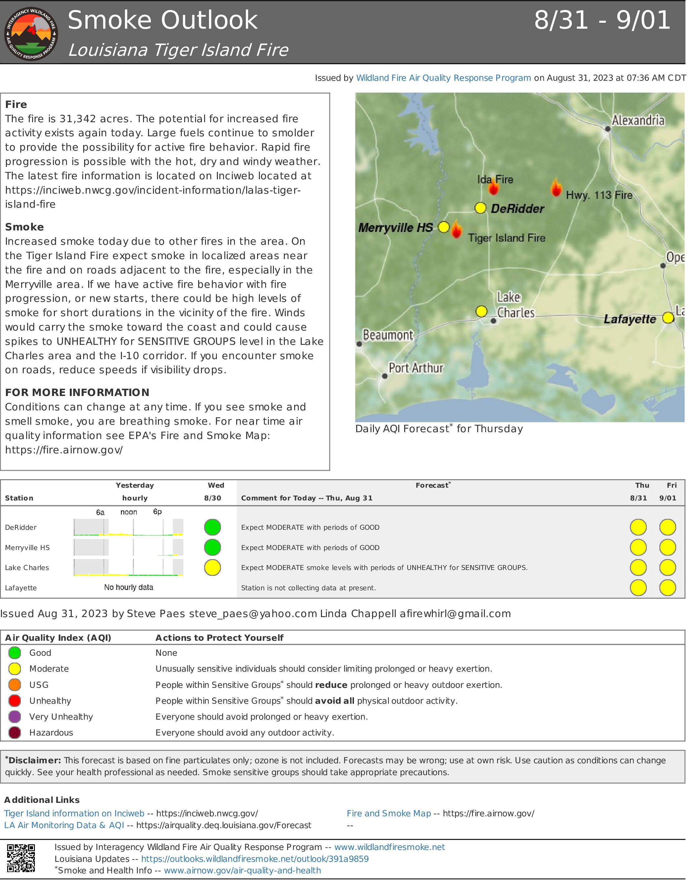
Tiger Island Fire Smoke Report 83123
Related Incident: Tiger Island Fire
Publication Type: News
Fire The fire is 31,342 acres. The potential for increased fire activity exists again today. Large fuels continue to smolder to provide the possibility for active fire behavior. Rapid fire progression is possible with the hot, dry and windy weather. The latest fire information is located on Inciweb located at https://inciweb.nwcg.gov/incident-information/lalas-tiger-island-fire
Smoke Increased smoke today due to other fires in the area. On the Tiger Island Fire expect smoke in localized areas near the fire and on roads adjacent to the fire, especially in the Merryville area. If we have active fire behavior with fire progression, or new starts, there could be high levels of smoke for short durations in the vicinity of the fire. Winds would carry the smoke toward the coast and could cause spikes to UNHEALTHY for SENSITIVE GROUPS level in the Lake Charles area and the I-10 corridor. If you encounter smoke on roads, reduce speeds if visibility drops.
FOR MORE INFORMATION Conditions can change at any time. If you see smoke and smell smoke, you are breathing smoke. For near time air quality information see EPA's Fire and Smoke Map: https://fire.airnow.gov
Tyee Ridge Complex Evening Update 083023
Related Incident: Tyee Ridge Complex
Publication Type: Announcement
Acreage: 4,770
Containment: 5%
Another Night of Busy Firefighting Ahead for Tyee Ridge Firefighters
UMPQUA, Ore. – Firefighters have been working since last night with very active fire behavior on the Cougar Creek and Lighthouse Fires. Active fire behavior is expected tonight until cooler conditions and light showers arrive tomorrow morning. Today, firefighters controlled a number of spot fires that crossed containment lines, and worked to extend lines and build backup ones.
Water and retardant drops continued to support ground operations in areas of steep or inaccessible terrain. Single-engine air tankers and helicopters worked closely with heavy equipment operators and hand crews. Among the aircraft were two Chinook (CH47) helicopters, from the Oregon Air National Guard.
To the north, the Big Tom Fire saw more active fire, while there was increased mopup on the Hardscrabble, Blue Hole, and Yellow Point Fires, which are moving toward patrol status in coming days. Oregon State Fire Marshal task forces worked around structures, installing sprinkler kits along Hubbard Creek, Briarwood Road, and the Lighthouse community. They have continued to be integrated with Oregon Dept. of Forestry crews to assist in cutting lines and protecting threatened homes.
Continued active fire behavior is likely overnight. Night crews remain focused on digging hand line, attacking any spot fires that cross lines, and addressing slopovers. Crews will conduct tactical firing operations where possible to remove fuels between control lines and the fire’s edge.
The Douglas County Sheriff's Office raised evacuation levels in two areas to Level 3 (Go Now!), put two other areas on a Level 2 (Get Set) evacuation level. Two new
Level 1 (Be Prepared) evacuation areas were also announced. An estimated 197 persons have evacuated. No structures have been damaged or destroyed. The Red Cross shelter for evacuees now located at The Way Church of Sutherlin located at 1352 E. Central Ave. in Sutherlin, OR. To shelter livestock, contact Douglas County Animal Control at 541-440-4471. Companion pets can be sheltered at Saving Grace Pet Adoption Center in Roseburg.
Oregon Department of Forestry Team 1
Joe Hessel, Incident Commander
OSFM Red Team, Ian Yocum, Incident Commander