
Ridge Creek Fire Update Thursday August 31 2023
Related Incident:
Publication Type: News
Location: Approximately 3.5 miles east of the north tip of Hayden Lake, along the Hayden Creek Road (Forest Service Road 437) from the Ridge Creek drainage to South Chilco Mountain.
Start Date: 8/3/2023 Cause: Human-caused Size: 4,474 acres Containment: 49%
Total Personnel: 374 Heavy Equipment: 20 Engines: 14 Crews: 10
The "Ready" notification (level 1) evacuation status for the Bunco area was lifted yesterday. There are NO evacuation orders in Kootenai County. Please monitor official county sources for the most up-to-date information. https://www.kcsheriff.com/186/Emergency-Management
FIRE STATUS
The Ridge Creek Fire was reported on 8/3/23 at 2:30 PM in the Ridge Creek drainage, approximately three miles east of the northern tip of Hayden Lake. Investigators have determined that the fire was human-caused.
Yesterday, 1.5-1.8 inches of rain fell in and around the fire area. Estimates of total rainfall dropped within the fire perimeter are around 219.6 million gallons. Firefighters engaged in operations until weather conditions made it was unsafe to do so. They will continue to improve and mop up fire lines today as weather permits. Repairs to roads and other features damaged by fire suppression on all sides of the fire will continue as needed.
Fire personnel continue to strengthen indirect fire lines on the southeast portion of the fire along Roads 437 and 1507. Masticators and graders continue work on the 385 Road, and a chipping operation continues along Bunco Road on the fires northern end.
To the southwest, firefighters and heavy equipment continue to work on the 206 Road, as well as snagging trees and chipping on the 625 Road. Backhaul of equipment such as pumps and hoses and suppression repair are underway.
Structure protection continues in the Nunn Road, Bunco Road and Hayden Lake communities while crews begin to remove unused firefighting equipment. Initial attack firefighters are available to respond to any new starts in the surrounding area.
As fire behavior decreases and completion of tasks increases, firefighting personnel assigned to the Ridge Creek Fire will be released over the next several days and re-assigned to other incidents as needed.
WEATHER AND FIRE BEHAVIOR
Live and dead vegetation will remain wet from recent rainfall, and the weather pattern is not expected to provide drying conditions in the near term. Fire behavior analyst Kelly Cagle stated, "Little to no fire behavior is expected today, although some smoke may be visible in heavy timbers within the fire perimeter." Overall temperatures have decreased over the last two days, and total rainfall was 1.8 inches. Temperatures are expected to be a high of 65 and a low of 60, and winds are forecast to be 7-11 mph with gusts up to 16 mph. Relative humidity is expected to be 58-63%.
Air quality information is available at www.airnow.gov and www.wildlandfiresmoke.net.
CLOSURES AND SPECIAL MESSAGES — CHANGED
Kootenai County has lifted all evacuation notices.
A daylight hours temporary flight restriction remains in place. Information is available at https://tfr.faa.gov/save_pages/detail_3_3347.html
Closure Order #01-04-03-23-003 for the Idaho Panhandle National Forest remains in place for Forest Service land north of Forest Service Road (FSR) 206, west of FSR 209 and FSR 385, and south of FSR 332; and for Forest Service land surrounding and north of the Yellowbanks Creek area and west of FSR 1535.
The closure includes all Forest Service Roads within the area:
- FSR 332, 385, 392, 428A, 437, 1507, 1511, 1530, 1552 and 1587.
- FSR 206 north of the junction with FSR 406.
- FSR 406 north of the junction with FSR 206.
- Bunco Road/FSR 332 from the National Forest boundary east to the junction of FSR 385.
- FSR 385 from the junction with Bunco Road/FSR 332 south to the junction of FSR 209 and FSR 794.
It also includes Forest Service Trails 69, 78, 234, 577 and 802.
This order is necessary for public and firefighter safety due to heavy fire traffic and equipment in the area. For more information, please see the Idaho Panhandle National Forest website at Idaho Panhandle National Forests - Alerts & Notices (usda.gov)
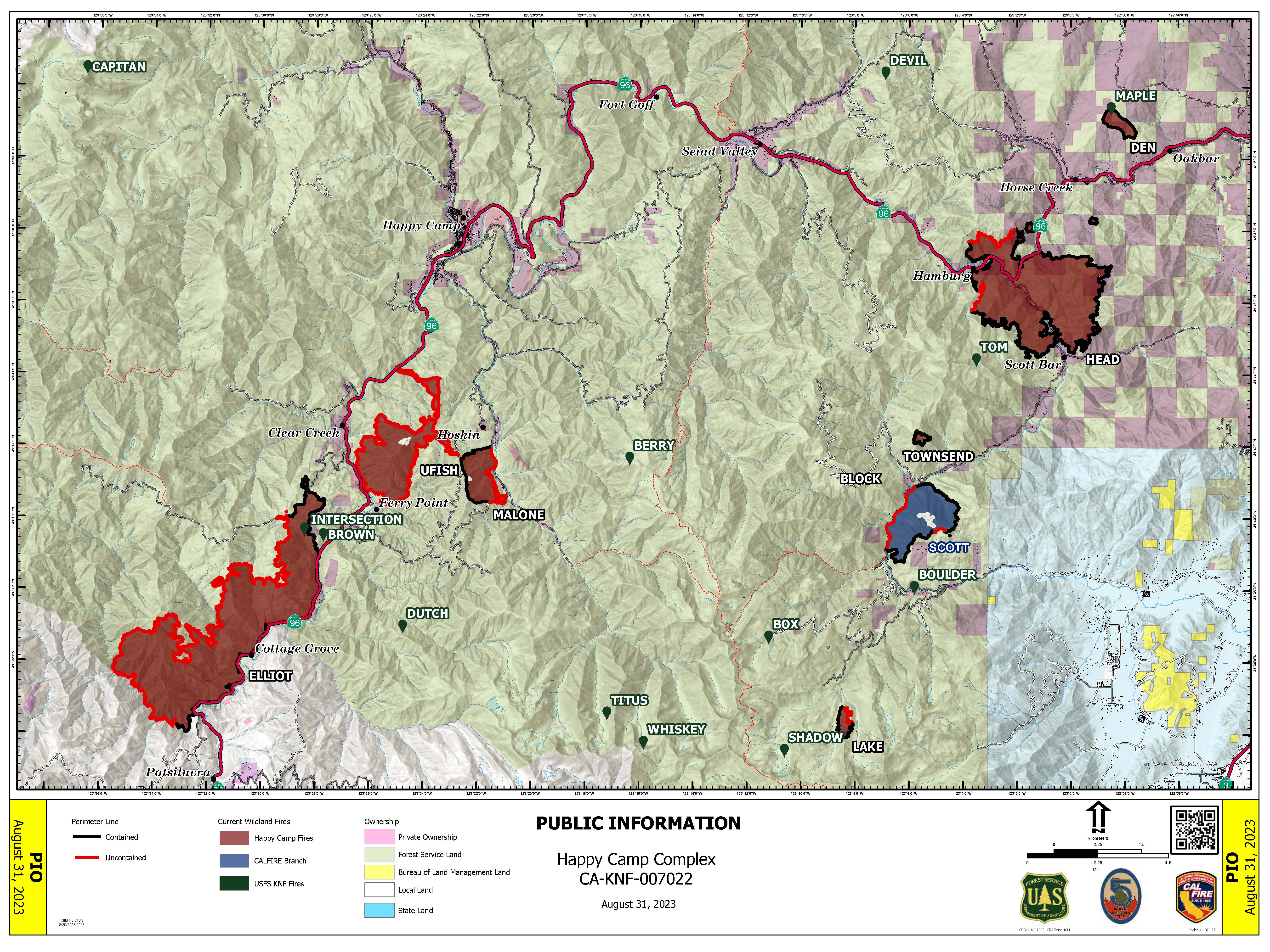
Happy Camp Complex Incident Update August 31 2023 Morning
Related Incident: 2023 Happy Camp Complex Klamath NF
Publication Type: News
WEATHER: Cooler temperatures and a chance of precipitation are forecasted for today and Friday on the Happy Camp Complex. The National Weather Service has issued a flash flood watch for late Thursday night through Friday evening for the Mckinney (2022) and Head fire burn areas.
WEST SIDE OVERVIEW (ACRES/CONTAINMENT): Elliot (11,452 acres, 25%), Ufish (4,651 acres, 3%)
The Ufish and Malone fires have merged and will now be referred to as the Ufish Fire. Last night, strategic firing operations took place on the north end of the Elliot and Ufish fires. Today, firefighters will focus on holding and securing fire lines and continue the strategic firing operation.
EAST SIDE OVERVIEW (ACRES/CONTAINMENT): Head (6,940 acres, 75%), Block (0.1 acres, 100%), Townsend (81 acres, 100%), Den (294 acres, 100%), Scott (1,886/ acres, 70%), Lake (199, acres, 50%)
The Head, Scott, and Lake fires remained in their established containment lines overnight. Today, firefighters will focus on gaining additional containment on the Head and Lake fires and mop up and patrol the Scott Fire.
EVACUATIONS: View current Siskiyou County evacuation orders and warnings by visiting: community.zonehaven.com. Siskiyou County residents are encouraged to sign up for rapid emergency notifications using the CodeRED emergency alert system at: www.co.siskiyou.ca.us/emergencyservices/page/codered-emergency-alert
An evacuation center has been established at the Kahtishraam Wellness Center, 1403 Kahtishraam, Yreka, CA 95097. Call (530) 340-3539 if you have questions regarding the shelter.
ROAD CONDITIONS: State Route 96 is now open. One-way traffic control remains in place in several areas while crews work to repair damaged infrastructure, remove debris, and stabilize slopes. Delays at the locations with one-way traffic control could be up to an hour or more. County road closures will be listed on the Siskiyou County Public Works website: www.co.siskiyou.ca.us/publicworks/page/closures-and-delays
FOREST CLOSURE: Two closure orders have been implemented: Happy Camp Complex Emergency Fire Closure, No.05-05-23-06; Happy Camp Complex Emergency Fire Closure, No. 05-05-23-07. View closure orders and maps at: www.fs.usda.gov/alerts/klamath/alerts-notices
TEMPORARY FLIGHT RESTRICTION (TFR): A TFR has been established over the fire area. Flight restrictions include the use of drones. The operation of drones under the TFR is prohibited.
PACIFIC CREST TRAIL: The Pacific Crest Trail is closed between the Shelly Fork Junction and Seiad as part of an area closure under Forest Order 05-05-23-07. It is suggested that northbound through-hikers exit the trail at Etna Summit and resume northward travel from Seiad.
AIR QUALITY: For information regarding smoke impacts and what you can do to protect yourself, visit the Siskiyou County Air Pollution Control District Fire and Smoke Information Website at: www.co.siskiyou.ca.us/airpollution/page/fire-and-smoke-information or AirNow.gov
Rescind Mandatory Evacuation Order Tin Soldier Complex
Related Incident:
Publication Type: Closures
BRIAN HEINO SHERIFF / CORONER
SHERIFF’S OFFICE
920 SOUTH MAIN STREET, STE 100, KALISPELL MONTANA
PHONE: 406-758-5585 FAX: 406-758-2420
FLATHEAD COUNTY
FOR IMMEDIATE RELEASE
Rescind Mandatory Evacuation Order – Tin Soldier Complex
Heinrude Community, MT - Thursday, August 31, 2023 @ 09:00 a.m.
Flathead County Sheriff Brian Heino in coordination with Southwest Area Incident Management Team 1 and the Flathead National Forest, has deemed that the imminent risk of danger to life and properties of the Heinrude Community in the vicinity of the Tin Soldier Complex has diminished at this time.
The Evacuation Order issued on August 1, 2023, for all properties have been rescinded and will be effective at 09:00 a.m. on Thursday, August 31, 2023.
A forest area closure is still in place, and residents will need to contact the Hungry Horse Ranger Station at (406) 387-3800 to make arrangements to access their properties. A Pre-Evacuation Warning or Evacuation Order may need to be reissued if the risk of danger to life and property should again warrant such action.
For the most current information regarding evacuation status please visit https://flathead.mt.gov/department-directory/oes/emergency-management/ridge-fire-information or call the Flathead County Office of Emergency Services Public Information Line at 406-758-2111.
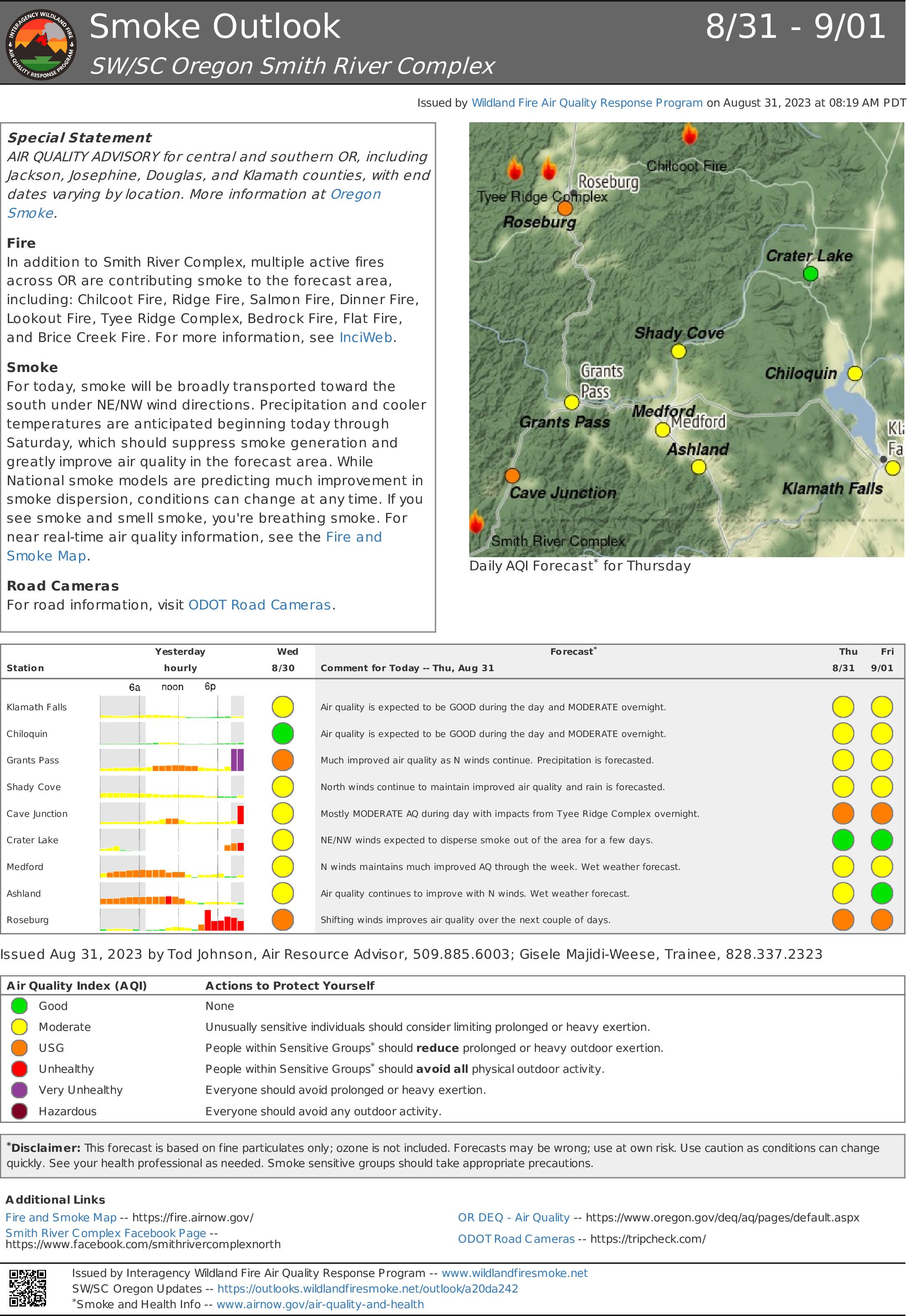
Smoke Outlook 831 91 Smith River Complex
Related Incident: Smith River Complex
Publication Type: News
Special Statement
AIR QUALITY ADVISORY for central and southern OR, including Jackson, Josephine, Douglas, and Klamath counties, with end dates varying by location. More information at Oregon Smoke.
Fire
In addition to Smith River Complex, multiple active fires across OR are contributing smoke to the forecast area, including: Chilcoot Fire, Ridge Fire, Salmon Fire, Dinner Fire, Lookout Fire, Tyee Ridge Complex, Bedrock Fire, Flat Fire, and Brice Creek Fire. For more information, see InciWeb.
Smoke
For today, smoke will be broadly transported toward the south under NE/NW wind directions. Precipitation and cooler temperatures are anticipated beginning today through Saturday, which should suppress smoke generation and greatly improve air quality in the forecast area. While National smoke models are predicting much improvement in smoke dispersion, conditions can change at any time. If you see smoke and smell smoke, you're breathing smoke. For near real-time air quality information, see the Fire and Smoke Map.
Road Cameras
For road information, visit ODOT Road Cameras.
River Road East Fire Daily Update Thursday August 31
Related Incident:
Publication Type: News
River Road East Fire
Fact Sheet
Thursday, August 31, 2023 at 10:00 am
NORTHERN ROCKIES TEAM 1
INCIDENT COMMANDER: BRENT OLSON
Information Phone: 406-345-5972
https://inciweb.nwcg.gov/incident-information/mtlnf-river-road-east-fire
Email: 2023.RiverRoadEast@firenet.gov
Facebook: https://www.facebook.com/riverroadeastfire
Location: 6 miles southeast of Plains, Montana
Start Date: 8/18/2023 Cause: Unknown Size: 17,227 acres Containment: 35%
Total Personnel: 625 Crews: 13 Engines: 37 Helicopters: 6
KEY MESSAGE: Containment means more than just constructing control line around a fire. After firefighting resources construct control line, the next step is to remove wildland fuel available to burn and/or extinguish sources of heat by mopping up. These actions are taken to secure control lines and prevent the fire from escaping under the current and expected weather forecast. Operations personnel then make the decision on if that area of the fire can be designated as contained.
CURRENT STATUS: The rain stopped falling on the fire area by early morning yesterday. Containment was increased along the northern flank of the fire (Henry’s Creek and Henry’s Peak) and crews continued to patrol and monitor that area. The northern control and containment lines continued to hold well. Along the eastern side along the National Forest and CSKT boundary, fire personnel worked to connect control lines and worked towards finishing some last segments. On the southeast corner crews used an Unmanned Aerial System (UAS) or drone to seek out and map heat sources to focus firefighter efforts for mop up. UAS can be a valuable tool used to cover a large area in a short amount of time. Crews continued to mop up and secure control lines on the northwest corner where firing operations were completed in recent days. Crews attempted to work on the indirect line on the southwest corner of the fire south of Pat’s Knob but had to turn back when they encountered hazardous conditions from recent rain.
PLANNED ACTIONS: Operations will start to consolidate some of the personnel around the fire perimeter and adjust the number of crews and engines based on increased containment. On the north, east, and southeast sides of the fire crews will patrol and mop up areas of heat. On the northwest corner firefighters will continue to mop up and secure the control line where firing operations were completed recently. Along the west side north of Pat’s Knob, equipment and crews will clean up the area where the shaded fuels break was constructed. A crew will reengage on indirect control line construction along the southwest corner of the fire if conditions allow. A slightly warming and drying trend in the weather begins today and continues through the weekend. Fire personnel will continue to work on control lines and patrol containment lines while monitoring fire activity as the weather conditions change.
WEATHER: The weather will be partly cloudy and start a slight warming and drying trend. Temperatures will be 63-73 degrees. Minimum relative humidity levels will be 32-42%. Winds will be from the west at 5-15 mph.
CLOSURES: The Flathead River closure from the Perma Bridge to the Confederated Salish & Kootenai Tribes boundary has been rescinded as of August 30, 2023.
Montana Fish, Wildlife and Parks has a closure in place on segments of the Flathead River and Clark Fork River within and near the River Road East Fire area. Details can be found at Restrictions and Closures: https://fwp.mt.gov/news/current-closures-restrictions.
The Lolo National Forest has an emergency closure of roads and trails (Closure #23-010-Lolo-D5) effective August 21, 2023. This Order is for public and firefighter safety during fire suppression efforts of the River Road East Fire. For a complete listing of the closed roads & trails visit: https://www.fs.usda.gov/alerts/lolo/alerts-notices.
A Temporary Flight Restriction (TFR) is in effect over the fire (FDC 3/9687) for the safety of aviation resources.
Lookout Bedrock Horse Creek Pothole Fires Daily Update 8312023
Related Incident: Lookout FireBedrock Fire2023 Horse Creek Fire
Publication Type: News
Alert: Highway 126 between Highways 242 and 20 reopened on Wednesday evening at 6:30 pm.
August 31, 2023
Morning Update
Lookout, Horse Creek, Pothole Fires Total Personnel: 940
Resources: 61 engines l 15 crews l 12 bulldozers l 35 water tenders l 11 masticators l 11 helicopters
Horse Creek: Size: 763 acres l Start Date: August 24, 2023 l Cause: Lightning l Containment: 10%
Fire behavior was limited yesterday. Fire crews and equipment completed a fireline around the perimeter of the fire and used a drone to identify hot spots and map the perimeter of the fire last night. This will help guide crews today as they widen and secure the line. Masticators are working to reduce fuels along the Horse Creek Road to create a fuel break and more secure control line.
Lookout: Size: 24,575 acres l Start Date: August 5, 2023 l Cause: Lightning l Containment: 17%
Three small spot fires were detected east of Highway 126 about four miles north of Belknap Springs, the largest was about two acres. Aviation resources dropped water and retardant on the fires immediately after detection. This aided on-the-ground resources to surround the fires with containment line. Crews will continue to secure and mop-up these spot fires today. Along the northern, western, and eastern flanks of the fire, fuel breaks continue to be prepared by tree fallers, fire crews, and heavy equipment along forest system roads to be used as primary and alternate control lines. On the southeast flank, near Belknap Springs, smoke may become more visible in the McKenzie River corridor as the fire slowly backs downhill toward completed containment lines near Highway 126. On the southern edge, crews are removing unneeded firehose, pumps, etc where containment lines are confidently secure. To provide a safer working environment for firefighters, teams of expert tree fallers are working out in front of crews to remove fire weakened trees. Please Note: In the northwest corner of the Lookout Fire, west of the Trail Bridge Reservoir, there is a mapping error, the fire has not expanded quite as much to the north. This error will be adjusted in tomorrow’s maps.
Pothole: Size: 109 acres l Start Date: August 25, 2023 l Cause: Lightning l Containment: 0%
No measurable growth on this fire during the past couple of days has provided firefighters opportunities to build direct fireline around most of this fire. Today they will work to connect control lines around the entire perimeter.
Bedrock: Total Personnel: 631
Size: 31,590 acres l Start Date: July 22, 2023 l Cause: under investigation l Containment: 80%
Resources: 24 engines l 11 crews l 6 bulldozers l 27 water tenders l 8 masticators l 11 helicopters
There has been no measurable growth on the Bedrock Fire for several days. Pockets of unburned fuels within the established control lines will continue to produce visible smoke. Fire crews are now focused on hauling out equipment, fire hose, and pumps and repairing damage to the land and forest roads (grading, installing water bars, and re-contouring dozer lines). Sprinklers and other fire suppression equipment are being removed from the community of Big Fall Creek as the danger of active fire has substantially diminished.
All Fires
Firefighters and law enforcement officers maintain a presence in evacuated areas. Trained firefighters are flying Unmanned Aerial Systems (UAS) or drones through the smoke to provide infrared heat imaging to locate hotspots near control lines and provide more accurate mapping of the fire perimeter. Drones also support firing operations in areas that are hard to access, which reduces risk to firefighters.
Weather
Widespread light to moderate rain is predicted beginning today through Friday, with a total accumulation of precipitation for Thursday and Friday between 0.5”-1”. For today, west/southwest light winds are expected with some gusty conditions on ridgetops and where river and creek drainages align.
Evacuation Centers: An evacuation center is in place at Westridge Middle School in Oakridge for evacuees and small pets from the Bedrock and Lookout Fires. A large animal shelter is established at the Lane County Fairgrounds in Eugene. An up-to-date and searchable evacuation map is available through Lane county’s website.
Lane County Evacuations: https://www.lanecountyor.gov/cms/one.aspx?pageId=19729054
Linn County Evacuations: https://www.linnsheriff.org/
Road Closures:
Highway 242, McKenzie Highway, is closed between milepost 61-76, 14 miles west of Sisters, Oregon to just east of the junction with Highway 126. Highway 126 is currently open. Please monitor Trip Check for any updates at: https://tripcheck.com/
Forest Closures: Willamette National Forest closure orders remain in place around all four fire areas. These closures help provide firefighters with safer driving conditions and decrease the potential for search and rescue operations that could interrupt firefighting activities. Closures can be found at: https://www.fs.usda.gov/detail/willamette/alerts-notices/?cid=fseprd552029
Restrictions: Fire Restrictions are in place on the Willamette National Forest: https://www.fs.usda.gov/willamette. Temporary Flight Restrictions remain in place over the Bedrock and Lookout fire areas.
Smoke Outlook: https://outlooks.wildlandfiresmoke.net/outlook/4c92bc1a The Fire and Smoke Map (fire.airnow.gov) is another source for air quality information.
Lookout Information Line: 541-215-6735 (8am-8pm)
Email: 2023.lookout@firenet.gov
Facebook: https://www.facebook.com/LookoutFire2023
Inciweb: https://inciweb.nwcg.gov/incident-information/orwif-lookout-fire
Bedrock Fire Information: 541-414-6272 (8am-8pm)
Email: 2023.bedrock@firenet.gov
Facebook: https://www.facebook.com/BedrockFire2023/
InciWeb Bedrock: https://inciweb.wildfire.gov/incident-information/orwif-bedrock-fire
Ridge Doris Point and Tin Soldier Fires Daily Update August 31 2023
Related Incident:
Publication Type: News
Ridge Fire
Location: 6 miles southeast of Hungry Horse
Size: 3665 acres
Percent Contained: 76%
Cause: Lightning
Start Date: July 30th, 2023 @ 3:45 PM
Personnel Assigned: 320
Doris Point Fire
Location: 8 miles south of Hungry Horse
Size: 1606 acres
Percent Completed: 95%
Cause: Lightning
Start Date: July 30th, 2023 @ 3:45 PM
Personnel Assigned: 22
Tin Soldier Fires
Location: 17 miles east of Swan Lake
Size: 8165 acres
Percent Completed: 94%
Cause: Lightning
Start Date: July 30th, 2023 @ 3:45 PM
Personnel Assigned: 80
Highlights:
As of 9 am this morning, the mandatory evacuation order for the Heinrude Community has been rescinded. The closure order for the Hungry Horse Reservoir still remains in place and residents of the Heinrude Community need to contact the Hungry Horse Ranger Station to make arrangements to access their properties. Recent precipitation has limited fire activity to smoldering on all fires and the rainfall has slowed repair work. A low amplitude ridge of high pressure will build over the region today through the weekend causing a slow warming and drying trend. However, another low-pressure system will impact the area with cooler temperatures and more moisture on Monday.
Operations:
Ridge and Doris Point Fires:
The Ridge and Doris Point Fire areas received over 1.5 inches of rain over the last operational period, which limited fire activity significantly. This also slowed ongoing repair work on contingency lines on the Ridge Fire. Additionally, debris came down on the roadway near the Doris Point Fire that firefighters were not able to remove. Montana Department of Transportation is assisting with the road debris removal. Firefighters also noticed rising creek water in the area and took action to remove pumps from streambeds and shorelines in anticipation of rising waters. Today crews will assess access and rollout on the roads, as well as load some pumps and hoses for backhaul. Ground resources will seek out opportunities for additional repair work on contingency lines.
Tin Soldier Fire:
The Tin Solider Fires received less precipitation than the Ridge and Doris Point Fires with 0.5 to 0.75 inches of rainfall, but amounts were significant enough to reduce fire activity and cause erosion issues on roadways accessing the fire areas. Some repair work was successfully conducted with excavators. Ground resources today will be assessing roads for areas that need improvement and grading. If able, crews will continue with mechanical thinning on the Bruce Fire, but the focus today will be on road access.
Weather and Fire Behavior:
Near-record precipitation amounts impacted the greater fire areas yesterday with 1.72 inches recorded at the Incident Command Post. A few light showers will be possible today, especially this morning, as the weather system continues to exit the region. A ridge of high pressure will be building over the fires today through Friday allowing for a warming and drying trend.
Ridge, Doris Point, and Tin Soldier Fires: 66-71° in the lower elevations and 56-61° in the mid-slopes to ridges with minimum relative humidity at 40-45%. Winds on the Ridge and Doris Point Fires will be southwest 5-10 mph. On the Tin Soldier Fires winds will be southwest 5-10 mph with gusts to 15 mph.
The Hungry Horse Reservoir is closed to all public access, including both the east and west side roads. Residents of the Heinrude Community need to contact the Hungry Horse Ranger Station at (406) 387-3800 to arrange access to their properties. For the most current information regarding evacuation status please visit https://flathead.mt.gov/department-directory/oes/emergency-management/ridge-fire-information. As firefighting efforts continue on the Ridge Fire, Doris Point Fire, and Tin Soldier Fire the closure is in place to provide for public and firefighter safety. https://www.fs.usda.gov/alerts/flathead/alerts-notices/?aid=82283
Additional Information:
Residents should stay alert for changing conditions and visit https://www.ready.gov/wildfires for preparing for wildfires. Information for the Ridge, Doris Point, and Tin Soldier Complex Fires is found at https://inciweb.nwcg.gov/incident-information/mtfnf-ridge-fire.
Fire Information: 406-998-6074 (8:00 am to 7:00 pm)
Email: 2023.ridge@firenet.gov
https://www.facebook.com/ridge.fire.information https://www.youtube.com/@2023ridgefire
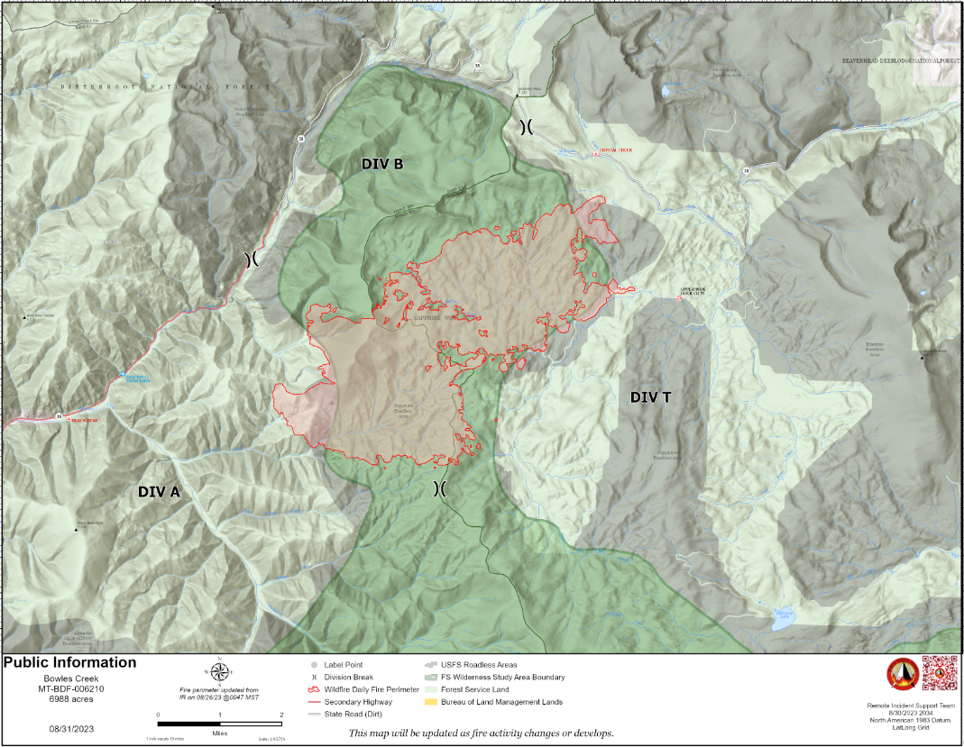
Bowles Creek Fire Update for August 31 2023
Related Incident: Bowles Creek Fire
Publication Type: News
The Nevada Team 3 Incident Management Team will be transferring command of the Bowles Creek fire to the Bitterroot and Beaverhead-Deerlodge National Forests on September 4th. All future updates will be posted to the Forest Facebook pages and the Inciweb site. Frequency of updates will be dictated by fire activity and/or changes to operations and closures.
Completion of fire management objectives has increased to 37%. The fire danger is below normal due to recent rains and predicted weather. Firefighters are focusing on suppression repair to mitigate adverse resource effects resulting from fire suppression activities. Firefighters will continue to patrol and monitor existing fire line and fire perimeter. Active fire growth is diminishing, but with a future drying trend, increased smoke may be visible at times. Hot spots within the fire’s perimeter will continue to smolder until extinguished naturally by repeated rain and snow.
Smith River Complex North update August 31 2023
Related Incident: Smith River Complex
Publication Type: News
Smith River Complex North update for Thursday, August 31, 2023
GRANTS PASS, Ore. – Firefighters continue to make steady progress establishing fire lines to protect the communities of the Illinois Valley and halt the spread of the Smith River Complex North.
“We are working aggressively to fully suppress this fire,” said Scott Blower, Wild River District Ranger for the Rogue River-Siskiyou National Forest.
With aviation support and favorable winds, tactical firing operations are occurring during both day and night shift. Tactical firing is strategic ignition by a team of fire experts under controlled conditions to bring the fire perimeter to a predetermined containment feature. It stops the forward progression of a wildfire while consuming ground litter and dried vegetation. Shrubs and trees are generally left intact.
Oregon State Fire Marshal (OSFM) task forces continue to expand defensible space around threatened structures, protecting them from any firebrands or embers. Firebrands are small pieces of burning vegetation such as small branches or leaves that can be carried across a fire line by the wind.
After dark, OSFM crews are conducting perimeter patrols, watching for spot fires and assisting wildland resources as needed.
Winds out of the northeast have been pushing the fire back on itself the past several days but are expected to shift again this weekend and come from the southwest. Cooler weather and measurable rain are also predicted this weekend, which may reduce fire activity, but will not be sufficient to extinguish the fire.
A Level 3 – GO NOW evacuation remains in place for the Hwy 199 area south of O’Brien from milepost 38 to the state line. A Level 2 – GET SET evacuation is in place for O’Brien and the Takilma area. A Level 1 – GET READY evacuation is in place north to Cave Junction. An American Red Cross evacuation shelter is located at Rogue Community College in Grants Pass. Livestock can be sheltered at the Josephine County Fairgrounds.
Due to fire activity, the public is encouraged to monitor the Rogue Valley Emergency Management site at https://rvem.org for evacuation updates. An interactive Fire First Response Map showing evacuation areas can also be found there.
Rogue River-Siskiyou National Forest has implemented an area and road closure order for the Smith River Complex. Visit the forest website for additional information at https://tinyurl.com/2s4hymku. The Bureau of Land Management Coos Bay District announced an emergency closure of public lands near the Oregon/California border. For additional information see https://www.blm.gov/orwafire.
South Fork Complex Update August 31 2023
Related Incident: South Fork Complex
Publication Type: News
People and Equipment: 850 personnel, crews, engines, dozers, water tenders
Current Situation:
3-9 Fire: 2,686 acres with 26% containment
Pilot Fire: 1,055 acres with 96% containment and air support
Pellitreau Fire: 3 acres with 100% containment
Sulphur Fire: 31 acres with 100% containment
46% overall containment for the Complex
3-9 Fire No major movement occurred along the southern perimeter yesterday in the area of the slop over, with the exception of a few spot fires that are contributing to a small amount of fire spread to the south. On the southeastern flank of the slop over, dozers, engines, and hand crews were able to go direct along the fire perimeter. Aircraft assisted crews by placing retardant along the south and southwestern flank of the slop over to prevent spread down to Pilot Creek and dozers opened up roads covered in fallen snags to increase access to the southwestern side of the slop over. Contingency line is being built along Henry Ridge west to Pilot Creek and firefighters will assess going north along Pilot Creek and going through Pilot Creek over to Pilot Ridge for additional contingency line. The northern division has 100% hand line completed around the perimeter. Fire personnel continue to add additional security to control lines, and spot fires in the northeast portion of the fire continue to be evaluated and secured with the assistance of aircraft.
Pilot Fire Crews have successfully finished 100% containment line around the perimeter and continued to focus on mopping up and adding depth. They will continue to get additional security on all control lines and backhaul supplies and trash. Resources are starting to be released from the Pilot Fire to assist with the 3-9 Fire.
The Pellitreau Fire and the Sulfur Fire are 100% contained. Firefighters will continue to monitor and patrol to ensure fire remains within the containment lines.
Weather: Maximum temperatures are expected to be 64-70 ºF, and minimum relative humidities are expected to be 35-42%. North-northwest winds are expected to be reduced compared to yesterday at 6-9 mph with gusts to 14 mph. In the evening, there is about a 20% chance of rain after 5:00 pm.
Evacuation Warning:
In Humboldt County, an Evacuation Warning continues to be in place for Zone HUM E 114 A and Zone HUM E 114 B. For more information go to the Humboldt County Sheriff’s Office website or call 707-268-2500. In Trinity County, an Evacuation Warning continues to be in effect for Zone HYM-505 and Zone HYM-509. Please continue to check the Trinity County Wildfire and Evacuation website for up-to-date information.
Forest Closure: Forest Closure orders for the South Fork Complex Fire continue to be in effect. They have been posted on the Shasta-Trinity National Forest website home page and on the Six Rivers National Forest (click on Forest Closures). Please avoid the closed areas.