
Informacin al da del Incendio Smith River Complex North 30 de agosto 2023
Related Incident: Smith River Complex
Publication Type: News
Información actualizada para el Incendio Smith River Complex North, Miércoles 30 de agosto, 2023
GRANTS PASS, Ore. – Durante el día de ayer, un cambio en la dirección del viento despejo el humo en el Valle de Illinois, lo cual permitió que los recursos de aviación apoyaran a los bomberos trabajando en tierra. Estos trabajadores se encuentran manteniendo el fuego fuera del contacto con las residencias, negocios y el corredor en donde se encuentran establecidas las líneas eléctricas a lo largo de Lone Mountain y el Hwy. 199.
Los esfuerzos de supresión fueron fortalecidos por el Governador de Oregon, Tina Kotek, que emitió una declaración de conflagración, movilizando el Grupo Blue para Manejo de Incidentes del Jefe de Bomberos Oregon así como también, cinco grupos de trabajo para la protección de la infraestructura y así poder asistir al distrito de Incendios de Illinois Valley. Este grupo de trabajo provienen de las ciudades de Marion, Polk, Lane, Benton y Klamath.
Este martes, el Grupo Blue se unió al Grupo 13 para Manejo de Incidente del Northwest. Después de la sesión informativa, las escuadrillas de bomberos se integraron dentro de las operaciones, continuando con las preparaciones en tierra alrededor de las casas y otro tipo de infraestructura. Con el grupo de trabajo OSFM (Jefe de Bomberos del Estado de Oregon) en el área, los bomberos forestales que estaban asistiendo en la protección de las viviendas, regresaron al trabajo primario de supresión de incendio. Gracias al trabajo del servicio aéreo con retardadores de incendio, las escuadrillas de bomberos podrán continuar con las operaciones de tácticas más agresivas de incendio con el objetivo de reforzar las líneas primarias de contención al Oeste de Lone Mountain Road y sobre la carretera del Hwy. 199. Durante el día de hoy, un viento del Noreste ayudará a empujar el fuego de regreso a su lugar de origen, pero también estará brindando dos elementos críticos en las condiciones climáticas del incendio: vientos fuertes y una recuperación pobre de la humedad relativa en horas de la noche. Los bomberos proseguirán monitoreando cuidadosamente las condiciones del sitio y harán cambios según sea necesario.
Un Nivel de Evacuación 3 – SALGA permanece en pie para el Hwy. 199 al sur de O’Brien extendiéndose desde la milla 38 hasta la línea estatal.
Un Nivel de Evacuación 2 – LISTOS ha sido emitido para O’Brien y el área de Takilma.
Un Nivel de Evacuación 1 – PREPARESE fue dictado para el área al Norte de Cave Junction. La Cruz Roja Americana abrió un centro de albergue localizado dentro de Rogue Community College en Grants Pass. Los recursos pecuarios (ganado) pueden guarecerse en el Fairgrounds de Josephine County.
Debido a la incrementación en la actividad del incendio, se aconseja al público en general que revisen el sitio para el Manejo de Emergencia de Rogue Valley: https://rvem.org para información actualizada acerca de las evacuaciones. Asimismo, podrán encontrar un mapa señalando las áreas de Respuestas Iniciales de incendio.
El Bosque Nacional de Rogue River-Siskiyou ha implementado una Orden de Cierre de área y carretera para el Incendio Smith River Complex. Para mayor información, visite: https://tinyurl.com/2s4hymku. La Oficina para el Manejo de Tierras (BLM) en Coos Bay ha anunciado un Cierre de Emergencia de tierras publicas cercanas a la frontera de Oregon/California. Para información más detallada visite: https://www.blm.gov/orwafire.
Happy Camp Complex Incident Update August 30 2023 Morning
Related Incident: 2023 Happy Camp Complex Klamath NF
Publication Type: News
VIRTUAL PUBLIC MEETING: A virtual public meeting for the Happy Camp Complex will be held tonight, August 30th, at 5:30 p.m. Fire personnel will provide an operational overview of the fire situation. The meeting will be live-streamed on Facebook (facebook.com/KlamathNF) and YouTube (youtube.com/@ciimt5). A Facebook account is not necessary to view the meeting.
WEATHER: Today will be the last dry day before moisture moves in on Thursday, bringing a chance of precipitation to the Happy Camp Complex.
WEST SIDE OVERVIEW (ACRES/CONTAINMENT): Elliot (9,915 acres, 21%), Malone (741 acres, 15%), Ufish (2,148 acres, 0%)
The main objective on the west side is to hold and secure the fire lines on all three fires. Firefighters worked throughout the night to secure containment lines and extinguish any hotspots on the east side of the Elliot Fire, along Highway 96. A strategic firing operation that was initiated last night in order to prevent the fire from spreading toward the north and west will be initiated again tonight if conditions allow.
Additionally, firefighters conducted a strategic firing operation towards the west on the Ufish Fire last night. They will continue with this operation tonight if conditions are favorable.
EAST SIDE OVERVIEW (ACRES/CONTAINMENT): Head (6,935 acres, 61%), Block (0.1 acres, 100%), Townsend (81 acres, 100%), Den (294 acres, 100%), Scott (1,886 acres, 70%), Lake (199, acres, 5%)
Firefighters made substantial progress on containing the Head Fire as they worked on its north and south flanks last night, ensuring the safety of the Hamburg community. The visibility conditions are now better, allowing air operations to make water drops over the fire, which will further help the firefighters on the ground today. The Scott and Lake fire crews continued their mop-up operation overnight, and those efforts will continue today.
EVACUATIONS: View current Siskiyou County evacuation orders and warnings by visiting: community.zonehaven.com. Siskiyou County residents are encouraged to sign up for rapid emergency notifications using the CodeRED emergency alert system at: https://www.co.siskiyou.ca.us/emergencyservices/page/codered-emergency-alert
An evacuation center has been established at the Kahtishraam Wellness Center, 1403 Kahtishraam, Yreka, CA 95097. Call (530) 340-3539 if you have questions regarding the shelter.
ROAD CONDITIONS: State Route 96 is now open. One-way traffic control remains in place in several areas while crews work to repair damaged infrastructure, remove debris, and stabilize slopes. Delays at the locations with one-way traffic control could be up to an hour or more. County road closures will be listed on the Siskiyou County Public Works website: https://www.co.siskiyou.ca.us/publicworks/page/closures-and-delays.
FOREST CLOSURE: Two closure orders have been implemented: Happy Camp Complex Emergency Fire Closure, No.05-05-23-06; Happy Camp Complex Emergency Fire Closure, No. 05-05-23-07. Please refer to https://www.fs.usda.gov/alerts/klamath/alerts-notices to view the orders and maps.
TEMPORARY FLIGHT RESTRICTION (TFR): A TFR has been established over the fire area. Flight restrictions include the use of drones. The operation of drones under the TFR is prohibited.
PACIFIC CREST TRAIL: The Pacific Crest Trail is closed between the Shelly Fork Junction and Seiad as part of an area closure under Forest Order 05-05-23-07. It is suggested that northbound through-hikers exit the trail at Etna Summit and resume northward travel from Seiad.
AIR QUALITY: For information regarding smoke impacts and what you can do to protect yourself, visit: https://www.airnow.gov/
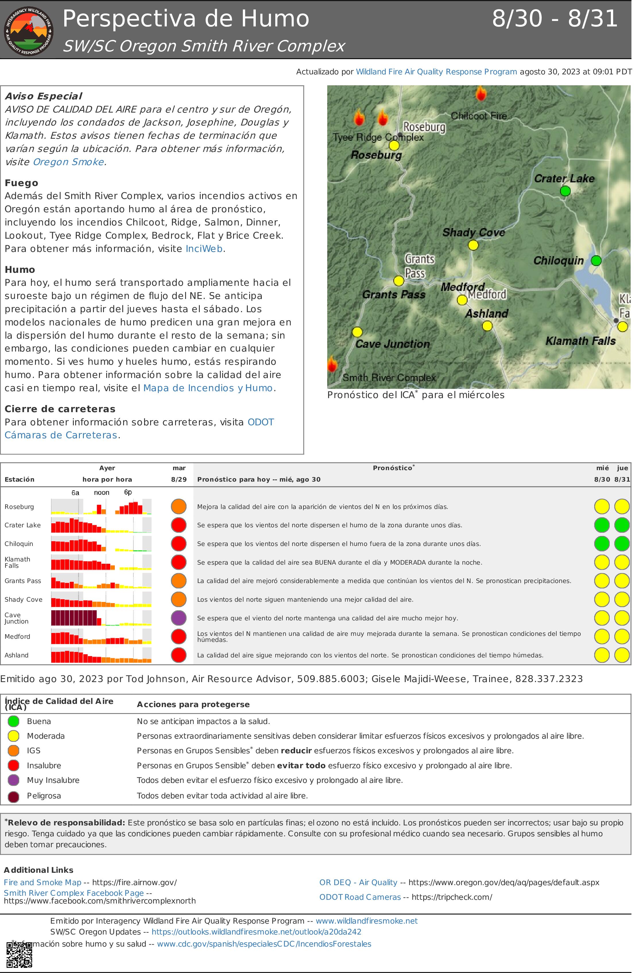
Perspectiva de Humo Smith River Complex 308 318
Related Incident: Smith River Complex
Publication Type: News
Aviso Especial
AVISO DE CALIDAD DEL AIRE para el centro y sur de Oregón, incluyendo los condados de Jackson, Josephine, Douglas y Klamath. Estos avisos tienen fechas de terminación que varían según la ubicación. Para obtener más información, visite Oregon Smoke.
Fuego
Además del Smith River Complex, varios incendios activos en Oregón están aportando humo al área de pronóstico, incluyendo los incendios Chilcoot, Ridge, Salmon, Dinner, Lookout, Tyee Ridge Complex, Bedrock, Flat y Brice Creek. Para obtener más información, visite InciWeb.
Humo
Para hoy, el humo será transportado ampliamente hacia el suroeste bajo un régimen de flujo del NE. Se anticipa precipitación a partir del jueves hasta el sábado. Los modelos nacionales de humo predicen una gran mejora en la dispersión del humo durante el resto de la semana; sin embargo, las condiciones pueden cambiar en cualquier momento. Si ves humo y hueles humo, estás respirando humo. Para obtener información sobre la calidad del aire casi en tiempo real, visite el Mapa de Incendios y Humo.
Cierre de carreteras
Para obtener información sobre carreteras, visita ODOT Cámaras de Carreteras.
San Juan National Forest Fall Prescribed Fire Program Burn Implementation
Related Incident: 2025 San Juan National Forest Prescribed Fire Program
Publication Type: Announcement
The Columbine and Dolores Ranger Districts on the San Juan National Forest have outlined their plans for the Fall Prescribed Fire Program.
The Columbine District has identified two areas for burn implementation:
· Beaver Meadows: Approximately 2,000 acres planned, located 10 miles northeast of Bayfield
· Southern HD mountains: Approximately 1,000 acres planned, located 12 miles southeast of Bayfield
The Dolores District has identified three areas for burn implementation:
· Haycamp Mesa: 10,658 acres located 10 miles east of Dolores, along the Haycamp Mesa Road, Forest Service Road NFSR 556
· Boggy Draw: 8,706 acres located 3 to 15 miles northeast of Dolores, along the Dolores-Norwood Road near Little Bean Canyon, Boggy Draw Road NFSR 527, and Cottonwood Canyon Road NFSR 532
· Salter: 5,379 acres located 7 to 15 miles east of Cahone, near Salter Y and Ormiston Point Road NFSR 521
Operations may begin as soon as weather permits and may continue into late fall, depending on weather, fuel conditions, and availability of fire personnel and other resources.
The forests in Southwest Colorado are part of a fire-adapted ecosystem, which historically experienced frequent, low-intensity fires on a large scale. Prescribed fire replicates that fire regime and helps keep our forest healthy, reducing the risk of bigger, catastrophic fires in the future.
River Road East Fire Daily Update Wednesday August 30
Related Incident:
Publication Type: News
River Road East Fire
Fact Sheet
Wednesday, August 30, 2023 at 10:00 am
NORTHERN ROCKIES TEAM 1
INCIDENT COMMANDER: BRENT OLSON
Information Phone: 406-345-5972
https://inciweb.nwcg.gov/incident-information/mtlnf-river-road-east-fire
Email: 2023.RiverRoadEast@firenet.gov
Facebook: https://www.facebook.com/riverroadeastfire
Location: 6 miles southeast of Plains, Montana
Start Date: 8/18/2023 Cause: Unknown Size: 17,227 acres Containment: 26%
Total Personnel: 685 Crews: 15 Engines: 40 Helicopters: 6
KEY MESSAGE: Following firing operations in recent days, fire crews focused on mop-up operations along the control lines to contain the fire and prevent its spread. Mop-up is the process of extinguishing or removing burning material near control lines, felling fire damage trees, and cooling ash pits to make a fire less likely to escape. Rain received overnight is expected to diminish fire activity today.
CURRENT STATUS: Yesterday, crews continued working on the control line along the north flank of the fire above Henry’s Creek. The containment lines around Henry’s Peak and the northeast corner were patrolled and monitored. On the eastern side of the fire along the forest and CSKT boundary, crews continued working on the control line making more progress to the south towards an indirect line already constructed. On the southeastern corner crews were again working in a couple of areas along the unburnt island and Knowles Creek. Over on the southwest corner and western flank crews and equipment continued their work on control line construction and strengthening. On the northwest corner where firing operations were completed yesterday, crews worked along the edge mopping up and extinguishing hot spots. Smoke continued to be visible as interior pockets of trees and vegetation burned. A cold front with thunderstorms moved through the fire area in the late afternoon with lightning and high winds. Firefighters from the incident supported the local units by responding to new fires started by the lightning.
PLANNED ACTIONS: The weather and road conditions will determine the plan of work for today following steady rain received overnight. Approximately ½ inch of rain fell on the fire area which will help with suppression efforts. Engine crews will monitor and patrol the Highway 200 corridor near Paradise. Crews will patrol and mop up along the northern, western and eastern control lines as well. If conditions allow, crews will continue constructing control line off the southwestern corner near Sheep Creek, moving west toward the Clark Fork River. Low cloud cover and forecasted rain could prevent helicopters from being used today.
WEATHER: The weather will be mostly cloudy with rain showers and a slight chance of thunderstorms in the morning and rain likely in the afternoon. Temperatures will be 55-65 degrees in the valleys and 48-58 degrees on the ridges. Minimum relative humidity levels will be 59-69%. Winds will be from the southwest at 20-30 mph.
CLOSURES: The Flathead River closure from the Perma Bridge to the Confederated Salish & Kootenai Tribes boundary has been rescinded as of August 30, 2023.
Montana Fish, Wildlife and Parks has a closure in place on segments of the Flathead River and Clark Fork River within and near the River Road East Fire area. Details can be found at Restrictions and Closures: https://fwp.mt.gov/news/current-closures-restrictions.
The Lolo National Forest has an emergency closure of roads and trails (Closure #23-010-Lolo-D5) effective August 21, 2023. This Order is for public and firefighter safety during fire suppression efforts of the River Road East Fire. For a complete listing of the closed roads & trails visit: https://www.fs.usda.gov/alerts/lolo/alerts-notices.
A Temporary Flight Restriction (TFR) is in effect over the fire (FDC 3/9687) for the safety of aviation resources.
Prescribed burns planned for the Dolores Ranger District this fall
Related Incident: 2025 San Juan National Forest Prescribed Fire Program
Publication Type: News
San Juan National Forest Prescribed Fire Program
DOLORES, Colo., August 30th, 2023—The San Juan National Forest’s Dolores Ranger District is planning to conduct several prescribed burns starting in September. Burning operations will take place over multiple days when weather and fuel conditions are favorable and may continue into fall based on conditions. Both hand and aerial ignition methods may be utilized, following the weather, fuel, and smoke parameters stated in the prescribed fire plan. Burning operations will be conducted by Forest Service personnel assisted by fire resources from cooperating agencies. The acres listed are planned, however, may not be fully accomplished due to weather and fuel conditions.
Project areas identified for burn implementation are:
- Haycamp Mesa: 10,658 acres located 10 miles east of Dolores, along the Haycamp Mesa Road, Forest Service Road (NFSR) 556
- Boggy Draw: 8,706 acres located 3 to 15 miles northeast of Dolores, along the Dolores-Norwood Road near Little Bean Canyon, Boggy Draw Road NFSR 527, and Cottonwood Canyon Road NFSR 532
- Salter: 5,379 acres located 7 to 15 miles east of Cahone, near Salter Y and Ormiston Point Road NFSR 521
Reintroduction of prescribed fire is necessary to improve and restore vegetative conditions. This effort will reduce hazardous ground fuels, lessen the risk of unplanned large-scale wildfire, help restore ponderosa pine ecosystems, and improve wildlife habitat. Prescribed fire also reduces the ladder fuels that can carry fire into the canopy, killing mature trees.
During burning operations, smoke may be visible around Mancos, Dolores, Dove Creek, Cortez, and HWY 491 between Dove Creek and Pleasant View. Smoke may settle into low lying valleys and the Dolores River Canyon overnight. Smoke monitoring will be conducted and ignitions will be scheduled to minimize smoke impacts to communities. Prescribed fire smoke may affect your health. More information can be found at: https://www.colorado.gov/pacific/cdphe/wood-smoke-and-health. There may also be temporary road and trail closures associated with burning operations.
Maps of the prescribed burn units and additional San Juan National Forest Prescribed Fire Program news can be found on InciWeb: https://inciweb.nwcg.gov/incident-information/cosjf-san-juan-national-forest-prescribed-fire-program.
For more information, please contact Dolores District Fire Management Officer Matthew Traynham at Matthew.Traynham@usda.gov.
For information on the San Juan National Forest, call (970) 247-4874, visit the forest website, or follow us on social media (Twitter and Facebook).
-USDA-
USDA is an equal opportunity provider, employer, and lender.
Gibbs Forest Fire Daily Update August 30 2023
Related Incident:
Publication Type: News
Gibbs Forest Fire Daily Update
August 30, 2023
11:30 pm
Size: 310 acres
Containment: 75%
Start Date: August 29, 2023
Cause: Under Investigation
Texas A&M Forest Service received a request for assistance from Walker County for a fire at State Highway 30 and Farm to Market 3179 12.5 miles west of Huntsville, Texas on August 29, at 3:30 pm.
In coordination with local fire departments, crews from Texas A&M Forest Service and USDA Forest Service- Sam Houston National Forest as well as several aviation resources were engaged in suppression efforts last night. Crews worked through the night constructing containment line around the fire. A burnout operation took place to enhance containment lines by removing a green vegetation pocket from the fire perimeter’s interior. Dozers were able to complete line construction around the fire at 5:50 am.
State crews are back on scene today with fresh resources containing multiple pieces of heavy equipment and engines to improve existing containment lines, patrol the area for spot fires, and mitigate any hazardous snags threatening containment lines.
Weather:
North winds continue to supply the area with some drier air with the departure of a weak frontal boundary that has now moved well offshore. That same wind has allowed temperatures to remain below the triple digit mark at most locations for today. The relative humidity is forecasted to remain in the high 50s to low 60s by daybreak tomorrow.
Evacuations:
There are no evacuations at this time.
Closures:
There are no road closures at this time.
Damages and Injuries:
Currently, there have been no reports of injuries from the public or first responders. No structure or critical infrastructure have been lost.
Camp Creek Fire Update for Wednesday August 30
Related Incident: Camp Creek Fire
Publication Type: News
Fire Size: 1,969 acres
Containment: 0%
Total Personnel: 306
Cool, cloudy, and moist conditions dampened fire behavior on Tuesday. The fire remained moderately active in heavy timber fuels with minimal additional increase in acres burned. The fire is reported as 1,969 acres with 0% containment.
The forecast calls for cool temperatures and cloudy conditions to continue throughout the week, with over a 0.25” of rain to the fire region. Weather conditions are expected to diminish spread potential and reduce fire behavior to smoldering and creeping with pockets of active fire behavior. Rain may not thoroughly wet the understory in areas with a closed tree canopy. These sheltered fuels, including thick duff, are still very dry and have the potential to carry fire. A drying trend is expected over the weekend. Smoke will likely be present in the area and may contribute to hazy skies.
Operations:
Fire personnel have cleared brush and timber adjacent to Forest Road 12 to act as a barrier to fire spread. Crews have been strategically burning small pockets of vegetation between the road and the fire’s edge. This will reduce the amount of available fuel along the fire perimeter to work towards containment. Fire personnel will continue to “plumb” the Forest Road 14, a term that refers to unrolling hoses and placing them along a fire line so water can be used to assist with suppression and containment efforts.
Portland Fire Department personnel have been working with the Portland Water Bureau to mitigate potential impacts to the water treatment plant, including removing burnable vegetation from around the plant building, as well removing excess stockpiles of the chlorine to reduce the likelihood of a gas leak.
A night shift will continue to patrol the fire’s edge for any spotting or increased activity throughout the evening. Their work will be aided by excellent overnight humidity recovery expected due to the change in weather.
No community meeting is scheduled this evening. Information officers will be staged at the Sandy Fire Station #71 from 12 to 2 p.m. and the Hoodland Thriftway from 2 to 4 p.m.
Incident information can also be found on Inciweb: https://inciweb.nwcg.gov/incident-information/ormhf-camp-creek-fire
Additional Information:
Smoke Outlook for August 30 and 31 - https://outlooks.airfire.org/outlook/2c7a8f9b
Closures and Evacuations:
Currently there are no fire related closures or evacuations, but people in the area should be prepared for both. Clackamas County residents can sign up to receive critical emergency messaging via email, phone call, and text: https://www.clackamas.us/dm/publicalerts
Temporary Flight Restrictions (TFR): There is a TFR over the fire area and public drone use is illegal.
Oregon Fire Update 30 August 2023
Related Incident: Oregon Fire
Publication Type: Announcement
Fire Size: 10,817 acres
Initial Start: 8/18/2023 at 1600 pm
Location: Approximately 4 miles northeast of Elk, WA.
Cause: Under Investigation
Containment: 79%
Resources Committed: 27 Engines, 9 Crews, 4 Bulldozers, 7 Water Tenders, 1 Skidgen
Personnel: 455
Road Closures: None
Elk, WA, - Current Situation: Northeast WA Incident Management Team (IMT)
3 took command of the fire this morning at 6 a.m. from Pacific Northwest
Incident Management Team 3 (PNW3). The two IMTs will work together again
today to ensure a thorough and seamless transition.
The full suppression strategy of the fire is close to being met. Most sections of
the fire are now transitioning from mop-up activities to being patrolled. Due to
receiving over one inch of rain on the fire last night, air resources are being
released from the incident. In the event air resources are needed they are
able to be called back.
Today’s activities: Across the fire perimeter and interior, successful mop-up
and suppression repair will lead to more areas shifting to a patrol status.
Firefighters continue to make improvements to containment lines on the east
flank of the fire. This area of the perimeter will continue to make use of
engines, hand crews, air assets and skidgens as needed to complete mopup.
The south, west, and north flanks of the fire will all be patrolled to seek
and mop-up any hot-spots.
Disaster assistance: Resources are available through the Spokane County
Disaster Assistance Center located at the Spokane Falls Community College,
Building 9, 3305 W. Whistalks Way, Spokane, WA 99224 - phone: (509) 998-
2750. Additional resources for property clean-up can be found at Spokane
Regional Health and Spokane Air: bit.ly/44o05BX.
Evacuations: All evacuations throughout the entire fire area have been
rescinded. An evacuation center for those in need remains open until there is
no further need at Riverside High School 4120 E. Deer Park Milan Rd,
Chattaroy, WA 99003.
Weather: Rain is likely through the day and expected to taper off during the
evening. 0.5" of rain is expected over the fire through Wednesday evening.
High temperatures will be nearly 20 degrees cooler and relative humidity
readings will be 25 to 30 percent higher. Winds will continue to be gusty
through the day with gusts up to 30 mph possible in the late morning and
early afternoon.
Smoke Outlook: Washington State Department of Ecology has up to date air
quality information at: enviwa.ecology.wa.gov/home/map.
For fire information contact the Public Information Officer at 509-508-3323 or
email 2023.oregon@firenet.gov
30 de agosto 2023 Informacin al da para el Incendio Flat y Incendio Anvil
Related Incident: Flat Fire
Publication Type: News
Información al día para el Incendio Flat y Incendio Anvil
Extensión: 34,242 acres
Origen: 2 millas Sureste de Agness, OR
Contencion: 58%
Fecha de Inicio: `15 de Julio, 2023
Personal: 366
Recursos: 11 escuadrillas de bomberos l 3 helicópteros l 17 camiones de bomberos l 3 buldóceres l 16 cisternas l 4 máquinas masticadoras
Actividades de hoy: Las cuadrillas continúan trabajando en estrecha colaboración con los Asesores de Recursos Forestales locales (READs) para proporcionar una reparación de supresión estrategizada en toda la zona del incendio. Los READ proporcionan orientación y tácticas a las cuadrillas mientras se esfuerzan por minimizar y restaurar los impactos del incendio en los recursos naturales y las tierras después de los esfuerzos de supresión del incendio. Además, los recursos están vigilando y patrullando el perímetro, centrándose en la línea no controlada del flanco este. Debido a lo accidentado del terreno en ese lado, los aviones están proporcionando reconocimiento aéreo junto con vigías preposicionados en posiciones calculadas sobre el terreno. El fuego no se ha movido fuera de su huella y sólo muestra algo de calor menor y humos interiores a veces. Los recursos de Ataque Inicial (AI) que apoyaban el incendio de Barklow fueron devueltos al incendio de Flat. En el incendio de Cedar, los recursos de ataque inicial siguen trabajando en la limpieza de combustible denso en terreno escarpado. Los recursos de ataque inicial se han comprometido a apoyar al bosque con nuevas actuaciones en la zona.
Informe matutino del Incendio Anvil
Extensión: 45 acres
Origen: 8 millas Este de Port Orford, OR
Contención: 0%
Fecha de Inicio: 25 agosto, 2023
Personal: 74
Recursos: 2 escuadrillas de bomberos l 2 helicópteros l 12 rapeles l 1 camión de bombero l 1 buldócer
Actividades de hoy: Las temperaturas más cálidas de la tarde aumentaron la actividad y empujaron el fuego hacia el norte. Sin embargo, la mejora de la visibilidad permitió a los aviones despegar con seguridad y ayudar en las labores de extinción. Aviones de ala fija junto con helicópteros apoyaron a los equipos de tierra proporcionando retardante y gotas de agua para ayudar a frenar la progresión del fuego. Los equipos están trabajando para asegurar el borde del fuego. El humo puede ser visible desde Port Orford y residencias a lo largo de Elk Creek Road. El fuego está ardiendo en el Grassy Knob Wilderness dentro de laderas empinadas y terreno difícil con acceso limitado. En las zonas inaccesibles, los aviones seguirán prestando apoyo según sea necesario para vigilar o realizar labores de extinción.
Tiempo: Se prevé un calentamiento y secado el miércoles con humedad por la tarde, que caerá por debajo del 30% en algunas zonas. Temperaturas más frías y el aumento de las posibilidades de lluvia se mueven sobre la región el jueves y el viernes como una vaguada de nivel medio se mueve sobre la zona.
Humo: Humo persistente dentro de la zona se está moviendo hacia el norte desde el Smith River Complex y la solución dentro de algunas comunidades cercanas, como Brookings. La perspectiva de humo para el Complejo Smith River está disponible en: Current Smoke Outlook for SW Oregon/NW California (wildlandfiresmoke.net)
Cierres: U.S. Highway 199 ha sido cerrado al norte de Gasquet debido a los incendios en el Six River National Forest, por favor, utilice U.S. Route 101 a SR 42 para todos los viajes hacia y desde el Valle de Rogue. El Servicio Forestal y las carreteras BLM no deben utilizarse como rutas alternativas debido a la actividad del fuego emergente. El Bosque Nacional Rogue River-Siskiyou (RRSNF) ha emitido una orden de cierre de la zona del incendio que incluye senderos, carreteras y una parte del río Illinois. Visite Rogue River-Siskiyou National Forest - Alerts & Notices (usda.gov) para más información.
Evacuaciones: Estado de evacuación de nivel 1 "Prepárense" para las zonas cercanas al Flat Fire. Enlace a más información: https://www.co.curry.or.us/government/county_sheriff/index.php
Restricciones: El peligro de incendio es actualmente extremo; la RRSNF está aplicando el Nivel 3 de Restricciones de Uso Público (PUR). El RRSF, Medford BLM y ODF han implementado PUR de nivel 3 en la sección salvaje del río Rogue. Para más información: Bosque Nacional Rogue River-Siskiyou - Noticias y eventos (usda.gov)