
South Fork Complex Update August 29 2023
Related Incident: South Fork Complex
Publication Type: News
People and Equipment: 750 personnel, crews, engines, dozers, water tenders
Current Situation: 3-9 Fire: 1,863 acres with 22% containment
Pilot Fire: 1,055 acres with 86% containment and air support
Pellitreau Fire: 3 acres with 100% containment
Sulphur Fire: 31 acres with 100% containment
45% overall containment for the Complex
3-9 Fire The northern division (Division O), has 100% hand line completed around the perimeter. Fire personnel continue to mop up and increase depth of the containment line. In the southern division (Division A), they improved the primary control lines along Berry Summit-Mad River Road, a dozer line, and Road 03N06 along the southern perimeter and continue to assess opportunities to go direct on the fire. Aircraft are supporting firefighting efforts with water and retardant drops in this area. Along the northwestern perimeter, crews continue to mop up and secure control lines down to and paralleling Pilot Creek. On the eastern portion of the fire (Division W), they continue to monitor and mop up spot fires with the assistance of helicopter water drops. A contingency line continues to be improved along road systems in the south near spot fires that started on Friday.
Pilot Fire: Crews have successfully finished 100% containment line around the perimeter and continued to focus on mopping up and adding depth. Aircraft supported cool-down efforts of interior heat with water drops in anticipation of increased winds on Monday night. Fire personnel will continue to secure and mop up the perimeter and improve contingency lines.
The Pellitreau Fire and the Sulfur Fire are 100% contained. Crews will continue to mop up the areas and monitor and patrol to ensure fire remains within the containment lines.
Weather: An area of low pressure approaching the California-Oregon coast is expected to bring cooler and windy conditions that will extend through most of this week. Maximum temperatures are expected to be 60-65 ºF. Minimum relative humidities are expected to be 43-48%. North-Northwest winds are expected to be 8-15 mph throughout the day with gusts of 30 mph.
Evacuation Warning: These remain in effect. Please continue to check the Trinity County Wildfire and Evacuation site for up-to-date status and locations: Trinity County Wildfire and Evacuation Map
Forest Closure: There are new Forest Closure orders for the South Fork Complex Fire that have been posted on the Shasta-Trinity National Forest - Home (usda.gov)and on the Six Rivers National Forest - Alerts & Notices (usda.gov). Please avoid the closed areas.
Little Mesa Fire Update August 29 2023
Related Incident: Little Mesa Fire
Publication Type: News
Little Mesa Fire - August 29, 2023
Recently, Little Mesa Fire has shown minimal fire behavior, but some heat remains within the interior on the southern end, between Black Point and Dry Mesa Road. Over the weekend the fire received .5” of precipitation. Firefighters continue to patrol the fire edge and monitor interior heat. Warm and dry conditions will develop Wednesday, with gusty winds 25-35 mph. Monsoonal showers and thunderstorms are back in the area on Thursday through the weekend. The Little Mesa Fire remains at 4,009 acres and 40% contained.
For updated information follow on these outlets:
Inciweb: https://inciweb.wildfire.gov/incident-information/coupd-little-mesa-fire
Facebook: @LittleMesaFire Twitter: @SWD_Fire
Spanish Translations of Daily Fire Updates Available
Related Incident: Camp Creek Fire
Publication Type: Announcement
Beginning Tuesday, August 29, Spanish translations of each daily fire update will be available online.
Click on an individual fire update on our News tab and scroll to the bottom of the narrative. There, you'll see a table with attachments. A printable Spanish version will be one of the attachments posted there.
Informacin al da del Incendio Smith River Complex North 29 de agosto 2023
Related Incident: Smith River Complex
Publication Type: News
Información al día para el Incendio Smith River Complex North, martes, 29 de agosto, 2023
GRANTS PASS, Ore. – Las escuadrillas de bomberos trabajando sobre el terreno, continúan trabajando arduamente, día y noche en las tácticas de incendio, a lo largo de la carretera 4402 al Oeste de Gilligan Butte y con el objetivo de proteger la infraestructura en O’Brien y en el Valle de Illinois River.
En los últimos días, a pesar de la presencia de un humo pesado que ha limitado a los helicópteros tratando de ayudar con los esfuerzos de supresión, se ha logrado asistir con otro tipo de estrategia activa de aviación. Un Sistema Aéreo Automatizado (UAS drones) equipado con sensores infrarrojos, ha logrado localizar varias fuentes pequeñas de calor las cuales no son visibles por la alta densidad del humo. Utilizando la información generada por UAS, el personal de incendio ha podido localizar estos puntos de emanación de calor y extinguirlos rápidamente.
El lunes, ráfagas de vientos alineadas sobre un terreno escarpado y sobre los drenajes, empujaron brasas hasta una milla de distancia del centro del incendio principal.
En las horas de la tarde del lunes, se localizaron ciertas zonas incendiándose en el drenaje de Rock Creek al Noroeste de Gilligan Butte cerca del empalme de la carretera 4402 y 461.
Se han estado desarrollando planes de tácticas de incendio para prevenir el peligro de que el incendio se propague y cruce la carretera 461 y la 4402 al Noroeste de Gilligan Butte. Esta operación es crítica para la protección de las comunidades a lo largo de Lone Mountain Road y O’Brien. Las operaciones en las tácticas de incendios fortalecen una línea de incendio al consumir el material de combustión situado entre el eje del fuego y las líneas de control establecidas. Esta implementación se realiza solamente cuando las condiciones del tiempo y el comportamiento del incendio se presentan favorables. Los bomberos tienen que monitorear en su totalidad y cuidadosamente dichas condiciones para prevenir el escape del fuego. El día de hoy, un frente débil del clima y desplazándose en las proximidades del incendio, nos brindara temperaturas frescas y ráfagas de vientos provenientes del Oeste. Para el miércoles, una vez que este frente haya pasado, se espera que el viento cambie hacia un alineamiento Norte-Sur, empujando el humo desde Smith River Complex hacia afuera del Valle de Illinois River. Por primera vez, en cinco días consecutivos, se espera que los helicópteros realicen su trabajo sobre el eje Norte del incendio. Sin embargo, todavía se podrá observar el humo proveniente de otros incendios más al Norte.
Un Nivel de Evacuación 3 – SALGA permanece en pie para el Hwy. 199 al sur de O’Brien extendiéndose desde la milla 38 hasta la línea estatal. Un Nivel de Evacuación 2 – LISTOS ha sido emitido para O’Brien y el área de Takilma. Un Nivel de Evacuación 1 – PREPARESE fue dictado para el área al Norte de Cave Junction. La Cruz Roja Americana abrió un centro de albergue localizado dentro de Rogue Community College en Grants Pass. También ofrece servicios para los residentes en el área que necesiten permanecer fuera del alcance del humo. Los recursos pecuarios (ganado) pueden guarecerse en el Fairgrounds de Josephine County.
Debido a la incrementación en la actividad del incendio, se aconseja al publico en general que revisen el sitio para el Manejo de Emergencia de Rogue Valley: https://rvem.org para información actualizada acerca de las evacuaciones. Asimismo, podrán encontrar un mapa señalando las áreas de Respuestas Iniciales de incendio.
El Bosque Nacional de Rogue River-Siskiyou ha implementado una Orden de Cierre de área y carretera para el Incendio Smith River Complex. Para mayor information, visite: https://tinyurl.com/2s4hymku. La Oficina para el Manejo de Tierras (BLM) en Coos Bay ha anunciado un Cierre de Emergencia de tierras publicas cercanas a la frontera de Oregon/California. Para información más detallada visite: https://www.blm.gov/orwafire.
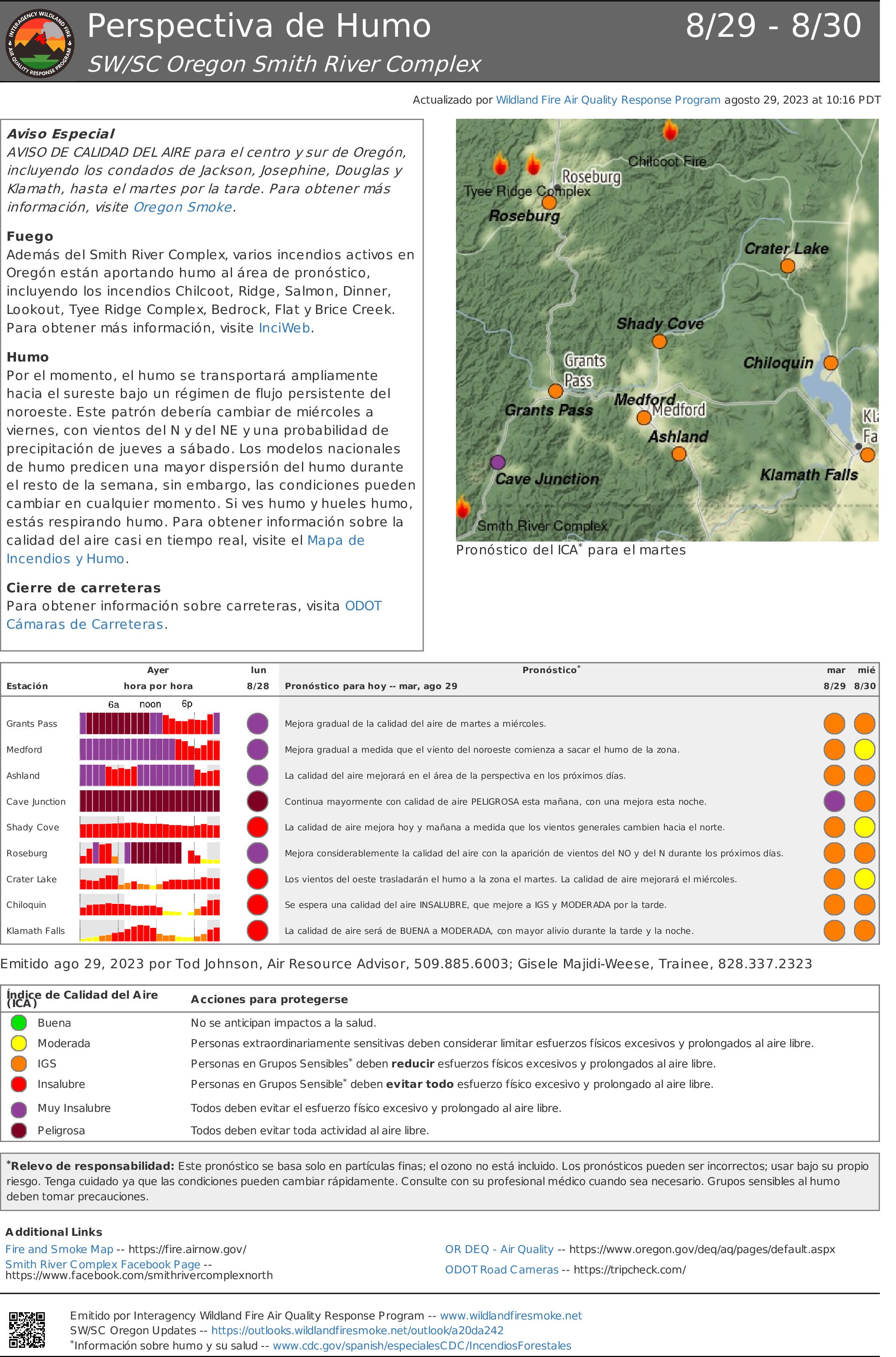
Perspectiva de Humo Smith River Complex 298 308
Related Incident: Smith River Complex
Publication Type: News
Aviso Especial
AVISO DE CALIDAD DEL AIRE para el centro y sur de Oregón, incluyendo los condados de Jackson, Josephine, Douglas y Klamath, hasta el martes por la tarde. Para obtener más información, visite Oregon Smoke.
Fuego
Además del Smith River Complex, varios incendios activos enOregón están aportando humo al área de pronóstico, incluyendo los incendios Chilcoot, Ridge, Salmon, Dinner, Lookout, Tyee Ridge Complex, Bedrock, Flat y Brice Creek. Para obtener más información, visite InciWeb.
Humo
Por el momento, el humo se transportará ampliamente hacia el sureste bajo un régimen de flujo persistente del noroeste. Este patrón debería cambiar de miércoles a viernes, con vientos del N y del NE y una probabilidad de precipitación de jueves a sábado. Los modelos nacionales
de humo predicen una mayor dispersión del humo durante el resto de la semana, sin embargo, las condiciones pueden cambiar en cualquier momento. Si ves humo y hueles humo, estás respirando humo. Para obtener información sobre la calidad del aire casi en tiempo real, visite el Mapa de Incendios y Humo.
Cierre de carreteras
Para obtener información sobre carreteras, visita ODOT Cámaras de Carreteras.
Commonly Asked Questions from Previous Community Meetings
Related Incident: Camp Creek Fire
Publication Type: News
Our Camp Creek Fire Public Information team has compiled and answered some of the commonly asked questions that were brought up at our community meetings on Monday, August 27 in Welches and Tuesday, August 28 in Corbett.
We will continue to do our best to address concerns and share information that may be useful to the public. In the meantime, we invite you to visit our Inciweb page on a daily basis, where we post an update each day under the News tab and also feature it on the home page as a Highlighted Activity for your convenience.
Do you think Eagle Creek, OR will be affected by this fire?
Eagle Creek is approximately 13.5 miles from the Camp Creek Fire. It's highly unlikely the Camp Creek Fire will affect the Eagle Creek community.
How far is this fire from Brightwood?
Currently, the Camp Creek Fire is approximately 5 miles from the community of Brightwood.
In 2020, the schools were delayed in opening due to fire an air quality. Will the Camp Creek Fire impact school openings?
At the August 27, 2023, public meeting in Sandy, Oregon, School Superintendent Aaron Bayer stated there is currently no plan to postpone the opening of schools due to air quality concerns. However, if the fire becomes more active and air quality is significantly affected, these discussions would be reevaluated.
Is the Sandy Ridge Bike Park still open?
For information on the Sandy Ridge Bike Park, visit their web site at https://www.blm.gov/programs/recreation/mountainbike/sandyridge
Are you using the 14 Road to the south of the Camp Creek Fire as a fire break?
Firefighters are clearing brush along the Road 14. This road will be used as a control feature.
Is the overnight humidity helping this fire?
Yes. Higher humidity levels help to reduce fire intensity.
Is the rain forecast for Tuesday (August 29) through Thursday (August 31) going to help us at all?
Yes. While the limited precipitation forecasted for the area will not extinguish the fire, it may help to temporarily moderate fire activity.
Why hasn’t any thinning or other mitigation been done in the Bull Run area if there have been concerns about the fuel load in the watershed?
The area within and around the Bull Run Watershed is off-limits to logging, mining, and public recreation.
What types and how many aircraft are working this fire?
Currently, there are three Type 1 and one Type 3 helicopters assigned to the Camp Creek Fire as well as two Canadair CL-415 (Super Scooper) fixed wing aircraft.
- Type 1 Helicopter: Type 1 helicopters are the largest, fastest flying, and the most expensive helicopters used on wildland fires. They can typically carry 700 gallons of water or retardant via a bucket or a snorkel that fills an internal tank. These helicopters can strategically drop thousands of gallons of water or retardant with pinpoint accuracy while working closely with ground personnel and other firefighting aircraft.
- Type 3 Helicopter: Type 3 helicopters are smaller. They have a higher cruise speed than a typical Type 2 helicopter and can arrive faster on the scene of an initial attack wildfire. They are capable of carrying four to five firefighters at a time and use a 180 gallon water bucket.
- Canadair CL-415 (Super Scooper): Water Scoopers are amphibious aircraft that skim the surface of a body of water, scoop water into an onboard tank, and then drop it on a wildland fire. Canadair CL-415 can hold up to 1,600 gallons of water and can take as little as 12 seconds to fill the tank to capacity. The aircraft can scoop from water sources that are roughly 6.5 feet deep and 300 feet wide. Scoopers usually pull water from lakes but can also scoop from rivers.
Are there any plans to shut off electrical power to the communities near the fire?
Under certain circumstances, Portland General Electric (PGE) may choose to deenergize their power lines. These might include periods of high winds or elevated fire weather conditions. Also, power might be cut off if a wildland fire is encroaching upon overhead power lines or structures. For more information on PGE policies and procedures, visit the PGE website at https://portlandgeneral.com/
Many locations only get cell service through Wi-Fi . If the power is cut off, cellular data won’t work. How will we be notified of evacuations?
Residents who live in areas without reliable cell phone or WiFi coverage might consider working with a friend or family member who does have reliable connectivity. They can monitor the situation and agree to alert you in the event a warning or evacuation notice is issued.
We have been waiting for evacuation information and have heard nothing even though the fire is only a few miles from our homes. Who can we talk to?
Current evacuation planning information is available on the Clackamas County website at https://www.clackamas.us/wildfires
How will I know when it's time to evacuate?
Clackamas County's Emergency Operations Center continues to monitor the Camp Creek Fire and is working in coordination with the incident management team. They have created a fire evacuation planning map, found on this site: https://www.clackamas.us/wildfires Here you can also sign up for emergency alerts, learn evacuation levels, and find other useful information on how to prepare for wildfires.
Where can I take my animals?
There are currently no evacuation orders in place in Clackamas County. In the event evacuations were ordered, plans for housing animals and livestock would be addressed by the county. For more information, contact the Clackamas County Disaster Manager at 503-655-8378 or by email at ccdm@clackamas.us.
Has the city posted water restrictions?
At this time, there are no water restrictions in place for Sandy, Oregon.
Are chemical fire retardants being used?
Fire retardants were used in limited areas during the initial attack on Friday, August 25 to support fire suppression efforts and protect the Bull Run Watershed. Fire retardants may be used again to support firefighting efforts. However, retardant will not be used in defined exclusion zones that drain into the Bull Run Reservoirs to protect water quality. Portland Water Bureau will continue to rigorously monitor for potential impacts to water quality. Follow this link to read the Interagency Wildland Fire Chemicals Policy and Guidance: https://www.fs.usda.gov/managing-land/fire/chemicals
Do fire suppression activities affect water quality?
Drinking water quality is best assured if the watershed remains forested. If the Forest Service decides that fire retardant must be used to prevent a catastrophic fire in the watershed, the Multnomah County Health Department has determined the risk to human health would be negligible not only because of the retardant’s components (85 percent water, 10 percent fertilizer, and five percent minor ingredients) but because of the dilution by the billions of gallons of water in the reservoirs. At all times, water quality from the Bull Run is rigorously monitored.
Tyee Ridge Complex Morning Update 082923
Related Incident: Tyee Ridge Complex
Publication Type: Announcement
Acreage: 2,896
Containment: 5%
Resources Expand and Line Construction Continues on Tyee Ridge Complex
Umpqua, Ore. – Firefighters are taking advantage of cooler temperatures, higher humidities, and minimal winds. However, they remain challenged by steep slopes and dry fuels. The Lighthouse and Cougar Creek Fires were active overnight. Oregon Department of Forestry wildland resources, including hand crews and dozers, continued line construction and holding, working to keep these fires in check as much as possible. Numerous resources including heavy equipment engaged along Hubbard Creek Road as the fire backed down to the road in many places. The Tyee Mountain Fire near Umpqua is also in mopup, although some activity is expected today. Crews made good progress on the Big Tom Fire, including mopup and plumbing, which is staging of hose lays around the fire perimeter. The Hardscrabble, Blue Hole, and Yellow Point Fires are moving toward patrol status.
Resources on the Complex have grown to over 900 personnel and containment is at 5%. Fifteen aircraft will be working throughout today’s shift pending smoke and weather conditions. The focus continues to be creating and holding line, and being ready for initial attack as needed in the Hubbard Creek area. Because weather conditions are largely favorable, crews aim to expand their gains to date and prepare for possible weather shifts later in the week. Oregon State Fire Marshal task forces will be in the Lighthouse Road area with sprinkler kits, and on Hubbard Road providing protection and removing hazard trees near residences.
Today, temperatures are forecast to reach 70 degrees with winds 5 to 8 miles per hour from the NW. Although fuels are becoming less dry, there is still potential for active fire behavior including uphill runs, torching, and spotting. Areas of heavy smoke are likely along with continued poor air quality.
All evacuation notices issued by the Douglas County Sheriff's Office remain unchanged. An estimated 183 persons have evacuated. The Red Cross shelter for evacuees is now located at The Way Church of Sutherlin located at 1352 E. Central Ave. in Sutherlin, OR. To shelter livestock, contact Douglas County Fairgrounds at 541-957-7010. Companion pets can be sheltered at Saving Grace Pet Adoption Center in Roseburg. To view the current evacuation information map, go to www.dcso.com/evacuations.
Ridge Creek Fire Update for August 29 2023
Related Incident:
Publication Type: News
Location: Approximately 3.5 miles east of the north tip of Hayden Lake, along the Hayden Creek Road (Forest Service Road 437) from the Ridge Creek drainage to South Chilco Mountain.
Start Date: 8/3/2023 Cause: Human caused Size: 4,369 acres Containment: 35%
Total Personnel: 466 Heavy Equipment: 18 Engines: 15 Crews: 13
The "Set" notification (level 2) evacuation status has been lowered for BUNCO AREA RESIDENTS to “Ready” (level 1). This would not have been possible without the tremendous work done by firefighters who continue to manage the fire. This status will continue to be reassessed. Please continue to monitor official sources for the most up to date information. https://www.kcsheriff.com/186/Emergency-Management
FIRE STATUS
The Ridge Creek Fire was reported on 8/3/23 at 2:30 PM, and is burning in the Ridge Creek drainage, approximately three miles east of the northern tip of Hayden Lake. Investigators have determined that the fire was human-caused.
Firefighters will work to construct, improve and mop up fire lines this morning and prepare for stormy weather this afternoon. They will continue to make significant progress with suppression, including beginning repairs to roads and other features damaged by fire suppression on all sides of the fire.
Overall, fire lines are holding, with isolated heat remaining in the interior. Firefighters continue to mop up, using water to extinguish hot spots near the perimeter. Crews patrol daily to check for heat that may pose a threat to the line.
Fire personnel continue to strengthen indirect fire lines on the southeast portion of the fire along Roads 437 and 1507. Masticators and graders continue work on the 385 Road.
Handline and dozer line is complete on the 406M Road, where yesterday firefighters ignited unburned vegetation in a tactical firing operation to strengthen containment. Helicopters and bulldozers supported firefighters during the successful operation and the containment line held. Chipping operations continue along Bunco Road.
To the southwest, resources gridded the fire area to extinguish hot spots. Firefighters continue to improve contingency fire lines. Grader work continues on the 206 Road as well as snagging trees and chipping on the 625 Road. Backhaul of equipment such as pumps and hoses and suppression repair are underway.
Structure protection continues in the Nunn Road, Bunco Road and Hayden Lake communities.
WEATHER AND FIRE BEHAVIOR
Humidity recovered poorly overnight, leading to a dry start to the day, with temperatures as warm as 70 degress at 4000 feet this morning. Highs will be near 85 degrees and minimmum relative humidity around 20 percent. Showers and thunderstorms are expected to reach the incident in the afternoon. Heavy rain is anticipated and will persist into the overnight hours. Storms have the potential to be severe with gusty outflow winds, small hail and lightning all possible.Winds are forecast to be 16-20 mph with gusts up to 30 mph. Winds are expected to continue overnight. A Flood Watch is in effect Tuesday afternoon through Wednesday afternoon in Kootenai County and much of northern Idaho.
Air quality information is available at www.airnow.gov and www.wildlandfiresmoke.net
CLOSURES AND SPECIAL MESSAGES — CHANGED
The Coeur d’Alene Dispatch Zone has reduced Fire Restrictions to Stage 1 for the Idaho Panhandle, including Kootenai County that begin at 12:01am on 8/30/23.
A daylight hours temporary flight restriction remains in place https://tfr.faa.gov/save_pages/detail_3_3347.html
Closure Order #01-04-03-23-003 for the Idaho Panhandle National Forest remains in place for Forest Service land north of Forest Service Road (FSR) 206, west of FSR 209 and FSR 385, and south of FSR 332; and for Forest Service land surrounding and north of the Yellowbanks Creek area and west of FSR 1535.
The closure includes all Forest Service Roads within the area:
• FSR 332, 385, 392, 428A, 437, 1507, 1511, 1530, 1552 and 1587.
• FSR 206 north of the junction with FSR 406.
• FSR 406 north of the junction with FSR 206.
• Bunco Road/FSR 332 from National Forest boundary east to the junction of FSR 385.
• FSR 385 from junction with Bunco Road/FSR 332 south to the junction of FSR 209 and FSR 794.
It also includes Forest Service Trails 69, 78, 234, 577 and 802.
This order is necessary for public and firefighter safety due to heavy fire traffic and equipment in the area. For more information please see the Idaho Panhandle National Forest website at Idaho Panhandle National Forests - Alerts & Notices (usda.gov)
-END-
Ridge Creek Fire
Idaho Panhandle National Forests
Coeur d’Alene River Ranger District
Fire Information 208-953-7022
2023.ridgecreek@firenet.gov
https://inciweb.wildfire.gov/incident-information/idipf-ridge-creek
https://www.facebook.com/USFSIPNF/
August 29, 2023
Ridge Doris Point and Tin Soldier Fires Daily Update August 29 2023
Related Incident:
Publication Type: News
Cold and Wet Weather Will Follow Today’s Hot and Dry Conditions on the Ridge, Doris Point, and Tin Soldier Fires
August 29, 2023 Daily Update
????? ????
3,665 Acres
76% Contained
332 Personnel assigned
????? ????? ????
1,600 Acres
68% Completed
44 Personnel Assigned
??? ??????? ???????
8,165 Acres
81% Completed
97 Personnel assigned
Highlights:
Conditions today will be hot and dry followed by an abrupt change in the late afternoon as a strong cold front pushes through the area bringing wind, rain, and possible lightning. Afternoon fire activity will increase on the southwest corner of Doris Point as well as the Tin Soldier Fires, but then be moderated by the rain and cool weather arriving later in the day and continuing through tomorrow.
Operations:
Ridge Fire:
Ground and aerial resources observed a small amount of heat in interior areas of the fire yesterday. Crews continue suppression repair work spreading wood chip piles along contingency lines west and north of the Ridge Fire. Resources will also be pulling in large berms from constructed dozer line.
Doris Point Fire:
Firefighters completed suppression repair operations yesterday and are felling snags upslope from roads to ensure public safety. Structure protection remains in the Lost Johnny Point area. Crews expect increased fire behavior with today’s weather and will actively monitor fire behavior to prevent movement across Lost Johnny Road.
Tin Soldier Fire:
Mechanical thinning with heavy equipment continues along the road north of Spotted Bear to mitigate any future fire growth in that direction. Crews have finished removing plumbing in the Heinrude community. Structure protection remains in place around the Spotted Bear Ranger Station. Observers documented smoke in interior pockets of the fire areas yesterday with similar conditions expected today.
Weather and Fire Behavior:
Hot and dry conditions will build today with an increase in southerly winds and a period of unstable conditions in the afternoon, creating near critical fire weather conditions later today. Fire activity is expected to increase, and smoke may be visible. A strong cold front will push through the fire locations this evening, bringing strong outflow winds, rainfall, and possible lightning. Steady rain is expected tonight through Wednesday with minimal warming.
Ridge, Doris Point, and Tin Soldier Fires: 90-95° in the lower elevations and 79-84° in the mid-slopes to ridges with minimum relative humidity at 18-23%. Winds will be variable 3-8 mph becoming south 5-13 mph in the afternoon. Wednesday will be cloudy and rainy with maximum temperatures 53-58° at lower elevations and 44-49° mid-slopes to ridges.
The Hungry Horse Reservoir is closed to all public access, including both the east and west side roads. The Forest Closure Order that includes the Heinrude Community remains in effect. As firefighting efforts continue on the Ridge Fire, Doris Point Fire, and Tin Soldier Fire the closure is in place to provide for public and firefighter safety. https://www.fs.usda.gov/alerts/flathead/alerts-notices/?aid=82283
Additional Information:
Residents should stay alert for changing conditions and visit https://www.ready.gov/wildfires for preparing for wildfires. Information for the Ridge, Doris Point, and Tin Soldier Complex Fires is found at https://inciweb.nwcg.gov/incident-information/mtfnf-ridge-fire.
Transfer of Sourdough Fire Command to North Cascades National Park Service Complex August 29 2023
Related Incident:
Publication Type: Announcement
The Northwest Incident Management Team 8 (NWIMT8) will be transferring management of the Sourdough Fire back to North Cascades National Park Service Complex on Tuesday, August 29, 2023 at 6 PM. This change reflects a successful suppression strategy that resulted in achieving containment along the full length of the fire’s southern perimeter that protects the critical values of homes and other structures, hydroelectric infrastructure, a power utility corridor, and SR 20. This level of containment also means that a reduced number firefighting resources and a smaller management team will be effective at managing the fire going forward.
After today, Tuesday, August 29, 2023, future communications related to the Sourdough Fire will be distributed through North Cascades National Park Service Complex.
Email: 2023.sourdough@firenet.gov
Facebook: https://www.facebook.com/NorthCascadesNationalPark