
Ridge Creek Fire Update for August 30 2023
Related Incident:
Publication Type: News
August 30, 2023
Location: Approximately 3.5 miles east of the north tip of Hayden Lake, along the Hayden Creek Road (Forest Service Road 437) from the Ridge Creek drainage to South Chilco Mountain.
Start Date: 8/3/2023 Cause: Human-caused Size: 4,474 acres Containment: 45% Total Personnel: 428 Heavy Equipment: 19 Engines: 15 Crews: 11
The "Ready" notification (level 1) evacuation status remains in effect for RESIDENTS IN THE BUNCO AREA. This status will continue to be reassessed. Please monitor official sources for the most up-to-date information. https://www.kcsheriff.com/186/Emergency-Management
FIRE STATUS
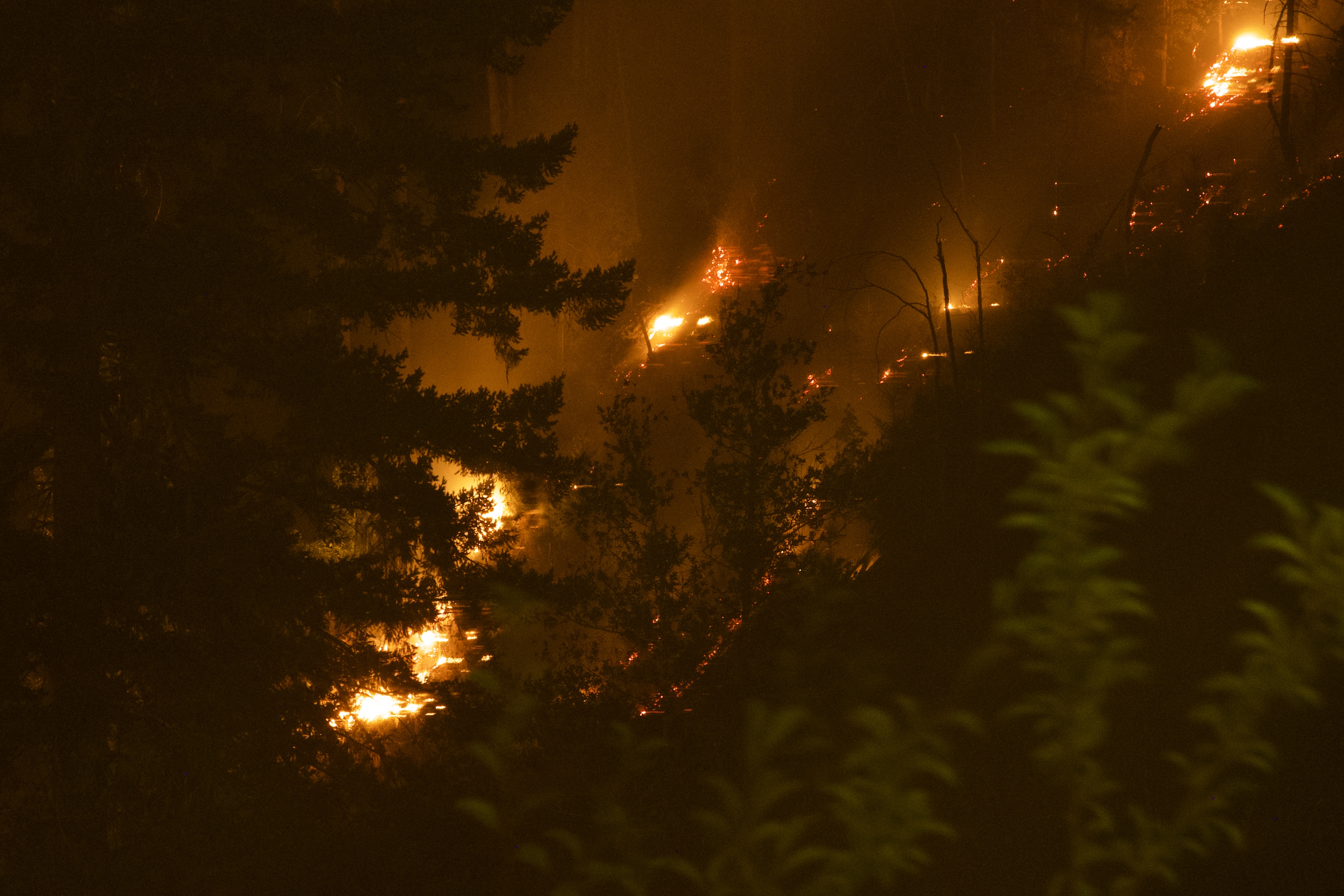
The Ridge Creek Fire was reported on 8/3/23 at 2:30 PM, and is burning in the Ridge Creek drainage, approximately three miles east of the northern tip of Hayden Lake. Investigators have determined that the fire was human-caused.
Firefighters will continue to improve and mop up fire lines today as weather permits. Significant rainfall and cooler temperatures will help firefighting efforts for several days. As weather permits, repairs to roads and other features damaged by fire suppression on all sides of the fire will continue.
Overall, fire lines are holding, with isolated heat remaining in the interior. Firefighters continue to mop up, using water to extinguish hot spots near the perimeter. Crews continue to patrol, checking for heat that may threaten the line.
Fire personnel continue to strengthen indirect fire lines on the southeast portion of the fire along Roads 437 and 1507. Masticators and graders continue work on the 385 Road, and a chipping operation continues along Bunco Road.
To the southwest, resources gridded the fire area to extinguish hot spots. Firefighters continue to improve contingency fire lines. Grader work continues on the 206 Road, as well as snagging trees and chipping on the 625 Road. Backhaul of equipment such as pumps and hoses and suppression repair are underway.
Structure protection continues in the Nunn Road, Bunco Road, and Hayden Lake communities. Initial attack firefighters are available to respond to any new starts in the surrounding area.
FIRE STATISTICS
As of 8/29/2023, the perimeter of the Ridge Creek fire is 22.3 miles, with 10.5 miles considered contained. Crews have completed 39.4 miles of direct and indirect fire lines. Air resources have dropped 270,000 gallons of water and 143,000 gallons of retardant.
WEATHER AND FIRE BEHAVIOR
Significant precipitation was observed in and around the fire area during the overnight hours. In some areas, as much as .70 inches of rain fell. The potential for continued rainfall is expected for the next several days. Live and dead vegetation is expected to be wet and unable to support any significant fire activity. No noteworthy fire spread or growth is anticipated due to cool and cloudy weather for the next few days.
Temperatures are expected to be a high of 59 and a low of 54, and winds are forecast to be 12-20 mph with gusts up to 20 mph. Relative humidity is expected to be 58-63%. A Flood Watch is in effect Tuesday afternoon through Wednesday afternoon in Kootenai County and much of northern Idaho.
Air quality information is available at www.airnow.gov and www.wildlandfiresmoke.net.
CLOSURES AND SPECIAL MESSAGES — CHANGED
Today the Coeur d'Alene Dispatch Zone reduced Fire Restrictions to Stage 1 for the Idaho Panhandle, including Kootenai County.
A daylight hours temporary flight restriction remains in place but was reduced today. Information is available at https://tfr.faa.gov/save_pages/detail_3_3347.html
Closure Order #01-04-03-23-003 for the Idaho Panhandle National Forest remains in place for Forest Service land north of Forest Service Road (FSR) 206, west of FSR 209 and FSR 385, and south of FSR 332; and for Forest Service land surrounding and north of the Yellowbanks Creek area and west of FSR 1535.
The closure includes all Forest Service Roads within the area:
- FSR 332, 385, 392, 428A, 437, 1507, 1511, 1530, 1552 and 1587.
- FSR 206 north of the junction with FSR 406.
- FSR 406 north of the junction with FSR 206.
- Bunco Road/FSR 332 from National Forest boundary east to the junction of FSR 385.
- FSR 385 from junction with Bunco Road/FSR 332 south to the junction of FSR 209 and FSR 794.
It also includes Forest Service Trails 69, 78, 234, 577 and 802.
This order is necessary for public and firefighter safety due to heavy fire traffic and equipment in the area. For more information, please see the Idaho Panhandle National Foret website at Idaho Panhandle National Forests - Alerts & Notices (usda.gov)
Lookout Bedrock Horse Creek Pothole Fires Daily Update 8302023
Related Incident: Lookout Fire2023 Horse Creek FireBedrock Fire
Publication Type: News
August 30, 2023
Morning Update
Community Public Meeting: There will be an in-person community meeting this evening Wednesday, at 5:00 p.m. at the McKenzie High School in Vida, Oregon. There will be a question-and-answer session following the presentations. For those who cannot attend, the meeting will be recorded and posted on both the Bedrock Fire and Lookout Fire pages. Information officers will monitor and answer incoming questions.
Horse Creek, Lookout, Pothole Fires Total Personnel: 914
Resources: 51 engines l 16 crews l 12 bulldozers l 30 water tenders l 11 masticators l 11 helicopters
Horse Creek: Size: 703 acres l Start Date: August 24, 2023 l Cause: Lightning l Containment: 0%
Fire behavior was limited yesterday morning but picked up in the late afternoon when the marine layer lifted over the fire. Containment lines continue to hold on the west, north and south edges of the fire. Air resources assisted firefighters on the ground to limit fire spread to the east. Fire crews and equipment are building a fireline from the ridgeline down into Horse Creek on the eastern edge of the fire.
Lookout: Size: 22,317 acres l Start Date: August 5, 2023 l Cause: Lightning l Containment: 17%
Cooler temperatures and higher humidity helped moderate fire behavior allowing firefighters to make good progress. In order to provide a safe working environment for firefighters, fallers will be working in advance of crews as both live and dead trees pose a threat in some work areas. Along the northern, western, and eastern flanks of the fire, fuel breaks are being prepared by tree fallers, fire crews, and heavy equipment along forest system roads. When completed, these roads will be used as primary and alternate control lines to contain fire spread. On the southeast flank, near Belknap Springs, the fire has been slowly backing downhill toward completed containment lines near Highway 126. Where containment lines are confidently secured along the south edge, crews are removing unneeded fire equipment like fire hose and pumps, while continuing to hold and secure the fireline.
Pothole: Size: 99 acres l Start Date: August 25, 2023 l Cause: Lightning l Containment: 0%
No measurable growth on this fire during the past couple of days has provided firefighters opportunities to build direct fireline around most of this fire. Today they will work to connect firelines around the perimeter.
Bedrock: Total Personnel: 641
Size: 31,590 acres l Start Date: July 22, 2023 l Cause: under investigation l Containment: 80%
Resources: 27 engines l 11 crews l 7 bulldozers l 27 water tenders l 8 masticators l 11 helicopters
There has been no measurable growth on the Bedrock Fire for several days. Pockets of unburned fuels within the established control lines will produce visible smoke. Firefighters continue to secure and patrol portions of the containment line along the northwest flank. Across most of the fire, the focus has shifted to hauling out equipment, firehose, and pumps and repairing damage to the land and forest roads (grading, installing water bars, and re-contouring dozer lines). Sprinklers and other fire suppression equipment are being removed from the community of Big Fall Creek as the danger of active fire is substantially diminished.
All Fires
Continued cooler temperatures and higher humidity for the past few days resulted in minimal or no fire growth on all fires. Firefighters and law enforcement officers maintain a presence in evacuated areas. Trained firefighters are flying Unmanned Aerial Systems (UAS) or drones through the smoke to provide infrared heat imaging to locate hotspots near control lines. Drones also support firing operations in areas that are hard to access, which reduces risk to firefighters.
Weather
Light precipitation is predicted over the fires this morning before giving way to slightly warmer and drier conditions this afternoon. Winds are predicted to be lighter from the west with possible gusts along ridgetops and where river and creek drainages align with winds. This condition often results in increased fire behavior where winds and drainages align. Cool, moist onshore flow is expected to increase, with about 1/3 of an inch of rain predicted beginning Thursday night through Friday.
Evacuation Centers: An evacuation center is in place at Westridge Middle School in Oakridge for evacuees and small pets from the Bedrock and Lookout Fires. A large animal shelter is established at the Lane County Fairgrounds in Eugene. An up-to-date and searchable evacuation map is available through Lane county’s website.
Lane County Evacuations: https://www.lanecountyor.gov/cms/one.aspx?pageId=19729054
Linn County Evacuations: https://www.linnsheriff.org/
Road Closures: Highway 242, McKenzie Highway, is closed between milepost 61-76, 14 miles west of Sisters, Oregon to just east of the junction with Highway 126. Highway 126 is currently open. Please monitor Trip Check for any updates at: https://tripcheck.com/
Forest Closures: Willamette National Forest closure orders remain in place around all four fire areas. These closures help provide firefighters with safer driving conditions and decrease the potential for search and rescue operations that could interrupt firefighting activities. Closures can be found at: https://www.fs.usda.gov/detail/willamette/alerts-notices/?cid=fseprd552029
Restrictions: Fire Restrictions are in place on the Willamette National Forest: https://www.fs.usda.gov/willamette. Temporary Flight Restrictions remain in place over the Bedrock and Lookout fire areas.
Smoke Outlook: https://outlooks.wildlandfiresmoke.net/outlook/4c92bc1a The Fire and Smoke Map (fire.airnow.gov) is another source for air quality information.
Lookout Information Line: 541-215-6735 (8am-8pm)
Email: 2023.lookout@firenet.gov
Facebook: https://www.facebook.com/LookoutFire2023
Inciweb: https://inciweb.nwcg.gov/incident-information/orwif-lookout-fire
Bedrock Fire Information: 541-414-6272 (8am-8pm)
Email: 2023.bedrock@firenet.gov
Facebook: https://www.facebook.com/BedrockFire2023/
InciWeb Bedrock: https://inciweb.wildfire.gov/incident-information/orwif-bedrock-fire
Please note: Due to an internet outage, we were unable to produce new maps for Lookout/Horse Creek/Pothole today. Little has changed from yesterday.
Tyee Ridge Complex Morning Update 083023
Related Incident: Tyee Ridge Complex
Publication Type: Announcement
Acreage: 4,876
Containment: 5%
Firefighters Prepare for an Active Day on Tyee Ridge Complex
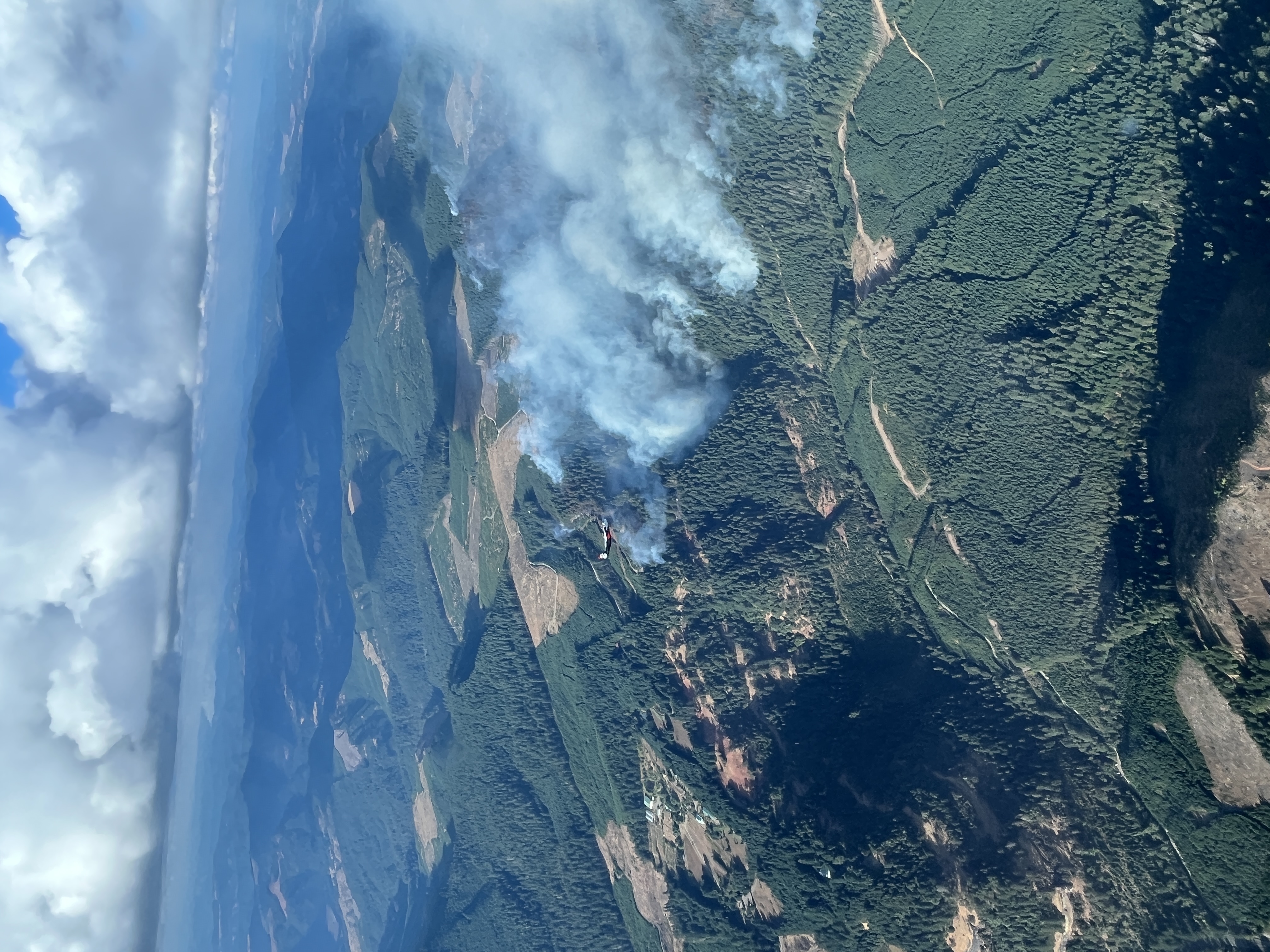
Umpqua, Ore. – Over the last two operational periods, fire behavior has been active. Overnight, crews made progress in some areas but faced challenges in others. The Hardscrabble, Blue Hole, Yellow Point, and Big Tom Fires continue to be in mopup, and tactical firing operations occurred on Big Tom until early this morning. The Lighthouse 3 Fire reached 656 acres. The Cougar Creek Fire grew to the south at Day Creek and to the NE, reaching 3,965 acres. Crews worked to hold and establish line and mop up spot fires throughout the night. Strong coordination between Oregon Department of Forestry wildland resources and Oregon State Fire Marshal structural task forces protected homes on Hubbard Creek Road.
Today, warmer temperatures and drier conditions are expected to keep fire behavior active. Fuels remain dry and ready to ignite, and rolling material and snags may create slopovers across lines. Firefighters will likely encounter backing and flanking, with the potential for isolated uphill runs and short range spotting in the afternoon. Clear and sunny weather conditions will drive this behavior, but may also allow for air resources to engage. Seventeen aircraft will be available including Single Engine Air Tankers (SEATs) and 17 helicopters. Today’s mission is to work aggressively to line and hold fires wherever possible. Task forces will mop up around residences on Hubbard Creek Road, conduct structure preparation on Briarwood Road, and scout opportunities for structure preparation on Cole Road east of the Lighthouse Fires. After today, weather conditions are likely to become cooler and showers are forecasted.
All evacuation notices issued by the Douglas County Sheriff's Office remain unchanged. An estimated 183 persons have evacuated. The Red Cross shelter for evacuees is now located at The Way Church of Sutherlin located at 1352 E. Central Ave. in Sutherlin, OR. To shelter livestock, contact Douglas County Animal Control at 541-440-4471. Companion pets can be sheltered at Saving Grace Pet Adoption Center in Roseburg. To view the current evacuation information map, go to www.dcso.com/evacuations.
Oregon Department of Forestry Team 1
Joe Hessel, Incident Commander
OSFM Red Team, Ian Yocum, Incident Commander
##
Smith River Complex North update August 30 2023
Related Incident: Smith River Complex
Publication Type: News
Smith River Complex North update for Wednesday, August 30, 2023
GRANTS PASS, Ore. – A shift in wind direction Tuesday cleared smoke out of the Illinois Valley, allowing aviation resources to go to work supporting ground crews who were working to keep the fire away from the homes, businesses and powerline corridor along Lone Mountain Road and Hwy 199.
Suppression efforts were also bolstered by Oregon Governor Tina Kotek’s issuance of a conflagration declaration, mobilizing the Oregon State Fire Marshal’s Incident Management Blue Team and five structure protection task forces to assist Illinois Valley Fire District with structure protection. The task forces are from Marion, Polk, Lane, Benton and Klamath counties.
The Blue Team joined Northwest Incident Management Team 13 in unified command Tuesday. After in-briefing, crews spent the day integrating into operations and continuing surface preparations around homes and other structures.
With the OSFM task forces in place, wildland firefighters assisting with structure protection returned to primary fire suppression work. Thanks to retardant drops by aviation, crews can continue with more aggressive tactical firing operations to strengthen primary containment lines west of Lone Mountain Road and along Hwy 199.
Although a northeasterly wind will help by pushing the fire back onto itself today, it also brings two elements of critical fire weather – strong winds and poor overnight relative humidity recovery. Firefighters will monitor conditions carefully and make adaptations as needed.
A Level 3 – GO NOW evacuation remains in place for the Hwy 199 area south of O’Brien from milepost 38 to the state line. A Level 2 – GET SET evacuation is in place for O’Brien and the Takilma area. A Level 1 – GET READY evacuation is in place north to Cave Junction. An American Red Cross evacuation shelter is located at Rogue Community College in Grants Pass. Livestock can be sheltered at the Josephine County Fairgrounds.
Due to fire activity, the public is encouraged to monitor the Rogue Valley Emergency Management site at https://rvem.org for evacuation updates. An interactive Fire First Response Map showing evacuation areas can also be found there.
Rogue River-Siskiyou National Forest has implemented an area and road closure order for the Smith River Complex. Visit the forest website for additional information at https://tinyurl.com/2s4hymku. The Bureau of Land Management Coos Bay District announced an emergency closure of public lands near the Oregon/California border. For additional information see https://www.blm.gov/orwafire.
Smith River Complex South Spanish Update August 29 2023
Related Incident: Smith River Complex
Publication Type: News
Fecha de inicio: Aug 15, 2023
Localizado: Bosque Nacional Seis Ríos
Causa: Relampagos
Hectáreas: 75,775
Contención: 7%
Personal: 3,035
Gasquet, Calif., Agosto 30, 2023. Los recursos contra incendios estaban preparados para una mayor actividad de incendios debido al aumento esperado de los vientos del oeste de la tarde. Aunque los vientos llegaron con ráfagas de hasta 20 mph en las elevaciones superiores, un aumento de la humedad ayudó a limitar la actividad general del incendio. Los bomberos pasaron el día usando mangueras para asegurar las líneas de contención al norte de Gasquet, cerca de Pioneer Road y a lo largo de la autopista 199 hasta French Hill Road. Estas líneas continúan manteniéndose y la amenaza de que un incendio alcance a Gasquet continúa disminuyendo cada día. Otro enfoque ha sido derribar árboles peligrosos y trabajar en áreas calientes a lo largo de la autopista 199 para acelerar la apertura del sistema vial crítico.
Los bomberos también centraron sus esfuerzos en el área donde el incendio Kelly y el incendio Coon están cerca de conectarse cerca de la carretera 405. Hace varios días, el incendio Coon avanzó un poco junto a Gordon Creek y desafió esta línea. Los fuertes vientos del oeste hicieron que apagar el fuego en el lado oeste de esta carretera fuera un desafío, pero los bomberos han tenido éxito hasta ahora.
Los vientos han comenzado a cambiar a una dirección más alejada de la costa hoy y se espera que permanezcan fuera del noreste hasta esta noche. Esto traerá un período de condiciones climáticas casi críticas para el incendio desde hoy hasta las horas de la tarde, especialmente en las áreas del incendio a más de 2500 pies de altura donde se pronostican vientos más fuertes. Los bomberos estarán en alerta máxima hoy durante estas condiciones climáticas críticas en anticipación de una mayor actividad de incendios. Estas condiciones adversas se moderarán rápidamente a medida que las condiciones se vuelvan más favorables mañana por la mañana. El potencial de lluvia ligera aumenta el jueves por la noche, junto con las nubes y el flujo en tierra a medida que una vaguada en el nivel superior del noroeste del Pacífico ingresa al área y persiste hasta el sábado.
Evacuaciones
Todas las órdenes de evacuación son emitidas por la Oficina del Sheriff del Condado de Del Norte. Si se encuentra en el área del condado de Del Norte, regístrese para recibir su Community Alert System para recibir notificaciones de emergencia. Niveles de evacuación al 27 de agosto a las 8:00 a.m., como sigue:
Nivel 3 “Vaya ahora”: Patrick Creek, Little Jones Creek, Copper Creek Drainage, Coon Creek/ 16n19 17n07, Washington Flat, Pioneer Road, Panther Flat Campground Area, todas las comunidades entre Slant Bridge Road al norte hasta la frontera de Oregón a lo largo de la autopista 199, Camino de la colina francesa.
Nivel 2 “Prepárate”: División baja, División alta, Rowdy Creek, Big Flat/Rock Creek.
Nivel 1 “Esté preparado”: Hiouchi desde Slant Bridge hasta el extremo este de North Bank Road.
Cierres
South Fork Road está abierta únicamente para residentes. El residente debe proporcionar prueba de residencia.
Rowdy Creek Road permanece cerrada en la parte superior de Low Divide.
Howland Hill Road (solo residentes)
Carretera del condado 316, Shelly Creek,
County Road 315 Mina de vacaciones
Carretera del condado 311 Antigua carretera de peaje de Gasquet
Carretera del condado 305 Weimer Road
Carreteras del Servicio Forestal 16N19 y 17N07
La autopista estadounidense 199 está cerrada en el condado de Del Norte desde Slant Bridge Road hasta Oregon Mountain Road (PM 16 a 31) debido a la actividad del incendio. Existe un cierre estricto en la U.S. 199 en la Estación Agrícola cerca de la frontera con Oregón. Para conocer las últimas condiciones de la carretera, visite quickmap.dot.ca.gov
A partir del domingo 20 de agosto de 2023, el Bosque Nacional Six Rivers ha emitido una orden de cierre de todo el bosque. https://www.fs.usda.gov/detail/srnf/notices/?cid=FSEPRD1096395
La Cruz Roja Estadounidense tiene un refugio en el recinto ferial del condado de Del Norte (421 US-101 N, Crescent City, CA 95531) para los desplazados por las evacuaciones. Los trabajadores de desastres de la Cruz Roja se están asociando con funcionarios locales para ayudar a garantizar que los evacuados reciban las necesidades, incluidos alimentos, agua y refugio.
Más información
Complejo del río Smith Inciweb: inciweb.nwcg.gov/incident-information/casrf-smith-river-complex
Bosque Nacional de los Seis Ríos: https://www.facebook.com/SixRiversNF
Oficina de Servicios de Emergencia Del Norte: https://www.facebook.com/DelNorteOfficeOfEmergencyServices
Oficina del Sheriff del Condado de Del Norte: https://www.facebook.com/DelNorteCountySheriffDepartment
Complejo del Río Smith Norte: https://www.facebook.com/smithrivercomplexnorth
Bosque Nacional Rogue River-Siskiyou: https://www.facebook.com/R6RRSNF/
Manejo de Emergencias del Condado de Josephine: https://www.facebook.com/josephinecountyEM
Para obtener un mapa de evacuación interactivo, visite: https://rvem.org/.
Flat Fire and Anvil Fire Morning Update 8302023
Related Incident: Flat Fire
Publication Type: News
Flat Fire
Size: 34,242 acres
Start Date: July 15, 2023
Point of origin: 2 miles southeast of Agness, OR
Containment: 58%
Total personnel: 366
11 crews l 3 helicopters l 17 engines l 3 bulldozers l 16 water tenders l 4 masticators
Today’s Activities: Crews continue to work closely with local forest Resource Advisors (READs) to provide for strategized suppression repair throughout the fire area. READs provide guidance and tactics to crews as they strive to minimize and restore fire impacts to natural resources and lands after fire suppression efforts. Additionally, resources are monitoring and patrolling the perimeter with focus on the uncontained line on the east flank. Due to the rugged terrain on that side, aircraft is providing aerial reconnaissance along with lookouts prepositioned in calculated positions on the ground. The fire has not moved out of its footprint and only showing some minor heat and interior smokes at times. Initial Attack (IA) resources supporting the Barklow Fire were released back to the Flat Fire incident. On the Cedar Fire, IA resources remain engaged with heavy mop up in dense fuel within steep terrain. IA resources are committed to supporting the forest with additional starts in the area.
Anvil Fire
Size: 45 acres
Start Date: August 25, 2023
Point of origin: 8 miles east of Port Orford, OR
Containment: 0%
Total personnel: 74
Resources: 2 crews l 2 helicopters l 12 rappelers l 1 engine l 1 bulldozer
Today’s Activities: Warmer afternoon temperatures increased activity and pushed the fire out to the north. However, better visibility allowed aircraft to safely launch and assist with suppression efforts. Fixed wing aircraft along with helicopters supported ground crews by providing retardant and water drops to help slow the fire’s progression. Crews are working toward securing the fire edge. Smoke may be visible from Port Orford and residences along Elk Creek Road. The fire is burning in the Grassy Knob Wilderness within steep slopes and difficult terrain with limited access. In inaccessible areas, aircraft will continue to support as needed to monitor or provide suppression work.
Weather: Warming and drying is anticipated on Wednesday with afternoon humidity, dropping under 30% in certain areas. Cooler temperatures and increasing rain chances move over the region Thursday and Friday as a mid-level trough moves over the area.
Smoke: Smoke lingering within the area is moving north from the Smith River Complex and settling within some nearby communities, like Brookings. The smoke outlook for the Smith River Complex is available at: https://outlooks.airfire.org/outlook/en/a20da242
Closures: U.S. Highway 199 has been closed north of Gasquet due to fires on the Six River National Forest, please use U.S. Route 101 to SR 42 for all travel to and from the Rogue Valley. Forest Service and BLM roads should not be used as alternate routes due to emerging fire activity. The Rogue River-Siskiyou National Forest (RRSNF) has issued a closure order for the fire area including trails, roads, and a portion of the Illinois River. Visit Rogue River-Siskiyou National Forest - Alerts & Notices (usda.gov) for more information.
Evacuations: Level 1 “Get Ready” evacuation status in place for areas in the vicinity of the Flat Fire. Link to more information: https://www.co.curry.or.us/government/county_sheriff/index.php
Restrictions: Fire danger is currently extreme; the RRSNF is implementing Level 3 Public Use Restrictions (PUR). Level 3 PURs on the Wild Section of the Rogue River have been implemented by the RRSF, Medford BLM and ODF. More information: Rogue River-Siskiyou National Forest - News & Events (usda.gov)
Settings - change map background and toggle additional layers
Filter - control incident types displayed on map.
Zoom to your location
Reset map zoom and position
Could not determine your location.
Show Legend
 Wildfire
 Prescribed Fire
 Burned Area
Response
Burned Area
Response Other
Other
Petes Lake Fire
Unit Information
Incident Contacts
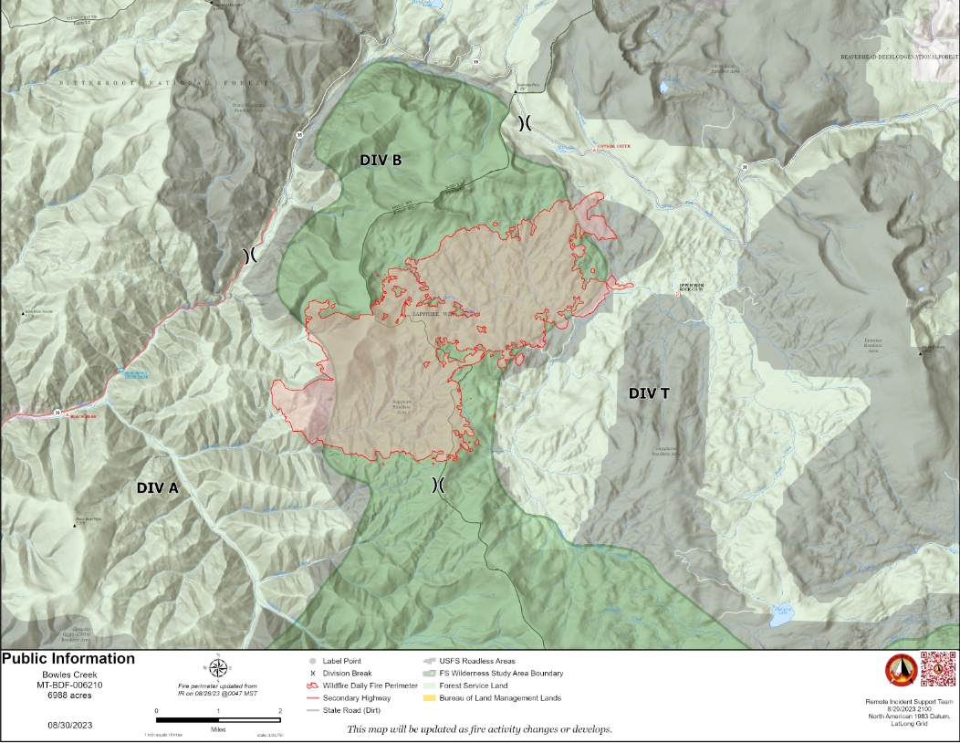
Bowles Creek Fire Daily Update for August 30 2023
Related Incident: Bowles Creek Fire
Publication Type: News
The Bowles Creek Fire is currently at 6,988 acres. Fire crews will be present along Hwy 38, Skalkaho Road, as fire suppression repair work along firelines, roads, trails, safety zones, and drop points continues. This work involves immediate post-fire actions taken to minimize environmental impacts resulting from fire suppression activities.
The fire completion has increased to 32%. Due to limited fire activity, fire personnel are beginning to focus on suppression repair to mitigate adverse resource effects resulting from fire suppression activities. Firefighters will continue to patrol and monitor existing fire line and fire perimeter.
2023 SRF Lightning Complex and Redwood Lightning Complex Update 83023
Related Incident: 2023 SRF Lightning Complex and Redwood Lightning Complex
Publication Type: News
2023 Six Rivers National Forest Lightning Complex and Redwood Lightning Complex August 30, 2023 – California Incident Management Team 2 is in command of the Six Rivers National Forest (SRF) 2023 Lightning Complex and Redwood Lightning Complex, which is now comprised of 20 fires. Total acreage is estimated at 14,783 acres with containment at 20%.
Redwood National and State Parks Area Lost – 55% contained. 722 acres. Crews continue full suppression tactics on the fire that is burning in the Lost Man watershed. CAL FIRE and Green Diamond Resource Company are collaborating in suppression efforts. Most of the fire is in previously logged, second growth forest. Crews have held the fire on Holter Ridge. Mop up has begun on the east side of the fire along Holter Ridge.
Bridge Ridge – 5% contained. 17-acres burning near the Devil Fire. Containment lines have been established around the perimeter and crews have begun mop up activities.
Devil – 100% contained. 12.4 acres. In patrol status.
Glen – 100% contained. .1 acre. In patrol status.
Hoopa Area
Lone Pine – 90% contained. 1,684 acres. Crews have almost completed removing unused hose line.
Orleans Area Pearch - East of Orleans is estimated at 3,466 acres. Crews have completed the firing operation along the southern edge to Drop Point 14. Aerial controlled firing operations utilizing an Unmanned Aerial System (UAS) began today to increase lines north from DP 14 to DP11. This operation will take several shifts to complete. Type 1 Structure Protection crews are working 24-hour shifts. Hose line and sprinklers have been deployed around values at risk. Structure Assessment Teams have been assessing structures for structure protection in the Somes Bar area.
The following fires are contained and in patrol status: Creek – 8 acres, Flat – 2.4 acres, Iron – 20 acres, Blue Creek - .1-acre, Big Foot - .8 acres.
The following fires are unstaffed due to difficult terrain and firefighter safety: Monument – 2 acres, Hancock – 1,425 acres, Merrill Mountain – 2 acres, Blue Creek 2 – 2,222 acres, Marlow – 1,231 acres, Let er-Buck - 60 acres. Copper – 98 acres.
Pearch Fire Evacuation Warning:
Orleans Area: Zone HUM-E009 (Southeast of the Klamath River in Orleans) Zone HUM-E008-B (Community of Orleans, west of Klamath River. East of Crawford Creek, including Orleans proper). Hwy 96 and Red Cap Road along the east bank of Klamath River, south from Salmon River, east to Orleans Mountain. Approximately 243 residents live in these 2 zones. Somes Bar Area: Zone SIS-1701: NORTH of Monte Creek Road, SOUTH OF Camp Three Road, EAST OF Camp Three Road, WEST OF Wooley Creek Trailhead. Anyone in these areas should be prepared for potential evacuations, including personal supplies and overnight accommodations. Be ready to go at a moment's notice.
Mosquito - Near the Bluff Creek area north of Mosquito Lake is estimated at 2,114 acres. The fire remains north of Forest Road 11N19 and west of Forest Road 12N12 (Cedar Camp Road). Containment lines along the 12N12 Road have held. Crews continue constructing containment lines.
Bluff #1 – 1,595 acres with minimal movement. Firing operations have been utilized to assist with line construction along the 11N16 Road. Crews are constructing indirect line. Weather – Today’s weather will be drier and warmer with high temperatures in the mid 90s. Winds will shift to North and North Northeast. This will bring smoke into the area from the Smith River Complex and Happy Camp complex. However, the Hancock Fire could see clear air with a possibility of greater fire growth.
Six Rivers National Forest Closures
Area and campground closures are in effect on Six Rivers National Forest. A new Closure Order was issued for the Orleans Ranger District and a portion of the Lower Trinity Ranger District. They can be found at: https://www.fs.usda.gov/detail/srnf/notices/?cid=FSEPRD1096395. Redwood National Park and State Parks Closures There are multiple closures in the parks due to several fires, including closures in the Lost Man area. For a full list of closures and impacts, please visit www.nps.gov/redw/planyourvisit/conditions.htm
Alert Notifications
ZoneHaven/Genasys for map and zone identification: https://protect.genasys.com
Humboldt County Residents Register for Humboldt Alert Notification: www.humboldt.gov/alerts
Siskiyou County Resident Register at Code Red Alert Notification: https://public.coderedweb.com/CNE/en-US/6F327CCDFFFD
Redwood National and State Parks Information Hotline
Phone: 707-464-6101 https://www.nps.gov/redw/planyourvisit/conditions.htm
2023 SRF Lightning Complex Fire Information
Phone: 530-536-0767
Email: 2023.lightningcomplex@firenet.gov
Hoopa Information Hotline
Phone: 530-618-2995
Email: serene.oes@gmail.com
Visit this link to access all resources listed on this update: www.linktr.ee/srffirepio
Ridge Doris Point and Tin Soldier Fires Daily Update August 30 2023
Related Incident:
Publication Type: News
Cool, Wet Weather Limits Fire Activity on
the Ridge, Doris Point, and Tin Soldier Fires
August 30, 2023 Daily Update
Ridge Fire
Location: 6 miles southeast of Hungry Horse
Size: 3665 acres
Percent Contained: 76%
Cause: Lightning
Start Date: July 30th, 2023 @ 3:45 PM
Personnel Assigned: 345
Doris Point Fire
Location: 8 miles south of Hungry Horse
Size: 1606 acres
Percent Completed: 83%
Cause: Lightning
Start Date: July 30th, 2023 @ 3:45 PM
Personnel Assigned: 42
Tin Soldier Fires
Location: 17 miles east of Swan Lake
Size: 8165 acres
Percent Completed: 86%
Cause: Lightning
Start Date: July 30th, 2023 @ 3:45 PM
Personnel Assigned: 80
Highlights:
Weather in the fire areas has changed significantly with the arrival of a strong cold front yesterday evening. Much cooler temperatures and rain are significantly limiting fire activity. Temporary flight restrictions have been lifted in the fire areas.
Operations:
Ridge Fire:
Firefighters worked on suppression repair including the construction of water bars on contingency lines west of the Ridge Fire. Water bars divert water drainage and reduce the likelihood of erosion. Crews worked on additional repair work near drop points on the west and north sides of the fire.
Doris Point Fire:
Fire personnel observed three areas of smoke on the west side of the Doris Point Fire yesterday. The smoke was in areas surrounded by previously burned fuels and were not expected to spread. Structure protection remains in the Lost Johnny Point area.
Tin Soldier Fire:
Resources observed smoke in the northeast and southeast corners of the Bruce fire yesterday. Mechanical thinning and repair work is almost complete along the road north of Spotted Bear. One small section of thinning will need to be completed by hand. Firefighting equipment is being collected and inventoried for removal from the area. Structure protection remains in place at Spotted Bear Ranger Station and private properties in that area.
Weather and Fire Behavior:
A low pressure system over the region will result in steady rain and significantly cooler temperatures today and through tonight. The fires should experience a total of 0.75 to 1.5 inches of rain by Thursday morning. A weak ridge of high pressure starts to build back over the region on Thursday allowing for warming and drying. No fire movement or growth is expected.
Ridge, Doris Point, and Tin Soldier Fires: 53-58° in the lower elevations and 44-49° in the mid-slopes to ridges with minimum relative humidity at 80-95%. Winds on the Ridge and Doris Point Fires will be southwest 5-10 mph with gusts to 15 mph. On the Tin Soldier Fires winds will be southwest 5-10 mph with gusts to 20 mph.
The Hungry Horse Reservoir is closed to all public access, including both the east and west side roads. The Forest Closure Order that includes the Heinrude Community remains in effect. As firefighting efforts continue on the Ridge Fire, Doris Point Fire, and Tin Soldier Fire the closure is in place to provide for public and firefighter safety. https://www.fs.usda.gov/alerts/flathead/alerts-notices/?aid=82283
Additional Information:
Residents should stay alert for changing conditions and visit https://www.ready.gov/wildfires for preparing for wildfires. Information for the Ridge, Doris Point, and Tin Soldier Complex Fires is found at https://inciweb.nwcg.gov/incident-information/mtfnf-ridge-fire.
Fire Information: 406-998-6074 (8:00 am to 7:00 pm)
Email: 2023.ridge@firenet.gov
https://www.facebook.com/ridge.fire.information https://www.youtube.com/@2023ridgefire