
Bowles Creek Fire Announcement
Related Incident: Bowles Creek Fire
Publication Type: Announcement
All future updates will be posted directly to the Forest Facebook pages and the Inciweb site. Frequency of updates will be dictated by fire activity and/or changes to operations and closures. For more information please call the Pintler Ranger District Office (406) 859-3211.
Tyee Ridge Complex Evening Update 083123
Related Incident: Tyee Ridge Complex
Publication Type: Announcement
Acreage: 6,678
Containment: 8%
Weather Improves Conditions on Tyee Ridge Complex
UMPQUA, Ore. – Today, rainfall was widespread throughout the Tyee Ridge Complex, with up to a quarter of an inch recorded at many locations. As a result, fire behavior was less active than in prior days. Smoldering and creeping occurred, with no spot fires or uphill runs. Firefighters took advantage of these conditions and built direct line at the fire’s edge in many locations. This tactic is intended to limit the overall footprint of a fire.
The weather also allowed crews to further increase mop up on the Big Tom, Hardscrabble, Blue Hole, and Yellow Creek Fires. Hotshot crews prepared line on the Lighthouse Fires for further tactical firing operations if needed. Ground operations made progress in several areas on the Cougar Creek Fire. They continued to attack and line existing spot fires and slopovers. Near residences on Hubbard Creek Road, Oregon State Fire Marshal task forces provided continued protection and enhanced defensible space, while wildland crews reinforced and held line. Hazard trees remain a challenge on many roads. Oregon Department of Forestry resources focused on identifying and removing those for firefighter and public safety.
Another significant hazard with the changes in weather is visibility. Smoke and fog were present today and will persist overnight. Motorists should use caution as sight distances will be limited.
Evacuation notices from the Douglas County Sheriff’s Office remained unchanged today. An estimated 197 persons have evacuated. No structures have been damaged or destroyed. The Red Cross shelter for evacuees now located at The Way Church of Sutherlin located at 1352 E. Central Ave. in Sutherlin, OR. To shelter livestock, contact Douglas County Animal Control at 541-440-4471. Companion pets can be sheltered at Saving Grace Pet Adoption Center in Roseburg.
Oregon Department of Forestry Team 1
Joe Hessel, Incident Commander
OSFM Red Team, Ian Yocum, Incident Commander
Happy Camp Complex Incident Update August 31 2023 Evening
Related Incident: 2023 Happy Camp Complex Klamath NF
Publication Type: News
WEATHER: Cooler temperatures and a chance of precipitation are forecasted this evening into Friday on the Happy Camp Complex. A flash flood watch issued by the National Weather Service is now in effect through Friday evening for the McKinney (2022) and Head fire burn areas.
WEST SIDE OVERVIEW (ACRES/CONTAINMENT): Elliot (11,459 acres, 25%), Ufish (4,651 acres, 3%) Hancock (1,653 acres, 0%)
As of this morning, the Ufish and Malone fires have merged and will now be referred to as the Ufish Fire. Today, firefighters worked to secure the perimeters of the Ufish and Elliot fires to ensure that the fire lines hold, preventing the fires from moving to the north. Tonight, crews will continue to hold and improve the fire lines.
This evening, the Hancock Fire, located southwest of the Elliot Fire, was added to the Happy Camp Complex. Fire managers are assessing the fire and planning suppression efforts.
EAST SIDE OVERVIEW (ACRES/CONTAINMENT): Head (6,940 acres, 75%), Block (0.1 acres, 100%), Townsend (81 acres, 100%), Den (294 acres, 100%), Scott (1,886 acres, 70%), Lake (199, acres, 55%)
Today, firefighters on the Head, Scott, and Lake fires continued to secure containment lines. Crews are working to complete the last two sections of uncontained fire line on the north and west sides of the Head Fire. Crews will patrol the areas tonight.
EVACUATIONS: View current Siskiyou County evacuation orders and warnings by visiting: community.zonehaven.com. Siskiyou County residents are encouraged to sign up for rapid emergency notifications using the CodeRED emergency alert system at: www.co.siskiyou.ca.us/emergencyservices/page/codered-emergency-alert
An evacuation center has been established at the Kahtishraam Wellness Center, 1403 Kahtishraam, Yreka, CA 95097. Call (530) 340-3539 if you have questions regarding the shelter.
ROAD CONDITIONS: State Route 96 is open. One-way traffic control remains in place in several areas while crews work to repair damaged infrastructure, remove debris, and stabilize slopes. Delays at the locations with one-way traffic control could be up to an hour or more. Scott River Road is now open with the exception of the area between Mill Creek to Highway 96. County road closures will be listed on the Siskiyou County Public Works website: www.co.siskiyou.ca.us/publicworks/page/closures-and-delays
FOREST CLOSURE: Two closure orders have been implemented: Happy Camp Complex Emergency Fire Closure, No.05-05-23-06; Happy Camp Complex Emergency Fire Closure, No. 05-05-23-07. View closure orders and maps at: www.fs.usda.gov/alerts/klamath/alerts-notices
TEMPORARY FLIGHT RESTRICTION (TFR): A TFR has been established over the fire area. Flight restrictions include the use of drones. The operation of drones under the TFR is prohibited.
PACIFIC CREST TRAIL: The Pacific Crest Trail is closed between the Shelly Fork Junction and Seiad as part of an area closure under Forest Order 05-05-23-07. It is suggested that northbound through-hikers exit the trail at Etna Summit and resume northward travel from Seiad.
AIR QUALITY: For information regarding smoke impacts and what you can do to protect yourself, visit the Siskiyou County Air Pollution Control District Fire and Smoke Information Website at: www.co.siskiyou.ca.us/airpollution/page/fire-and-smoke-information or AirNow.gov
Settings - change map background and toggle additional layers
Filter - control incident types displayed on map.
Zoom to your location
Reset map zoom and position
Could not determine your location.
Show Legend
 Wildfire
 Prescribed Fire
 Burned Area
Response
Burned Area
Response Other
Other
Anvil Fire
Unit Information
Incident Contacts
Water Sampling Station Protection
Related Incident: Camp Creek Fire
Publication Type: News
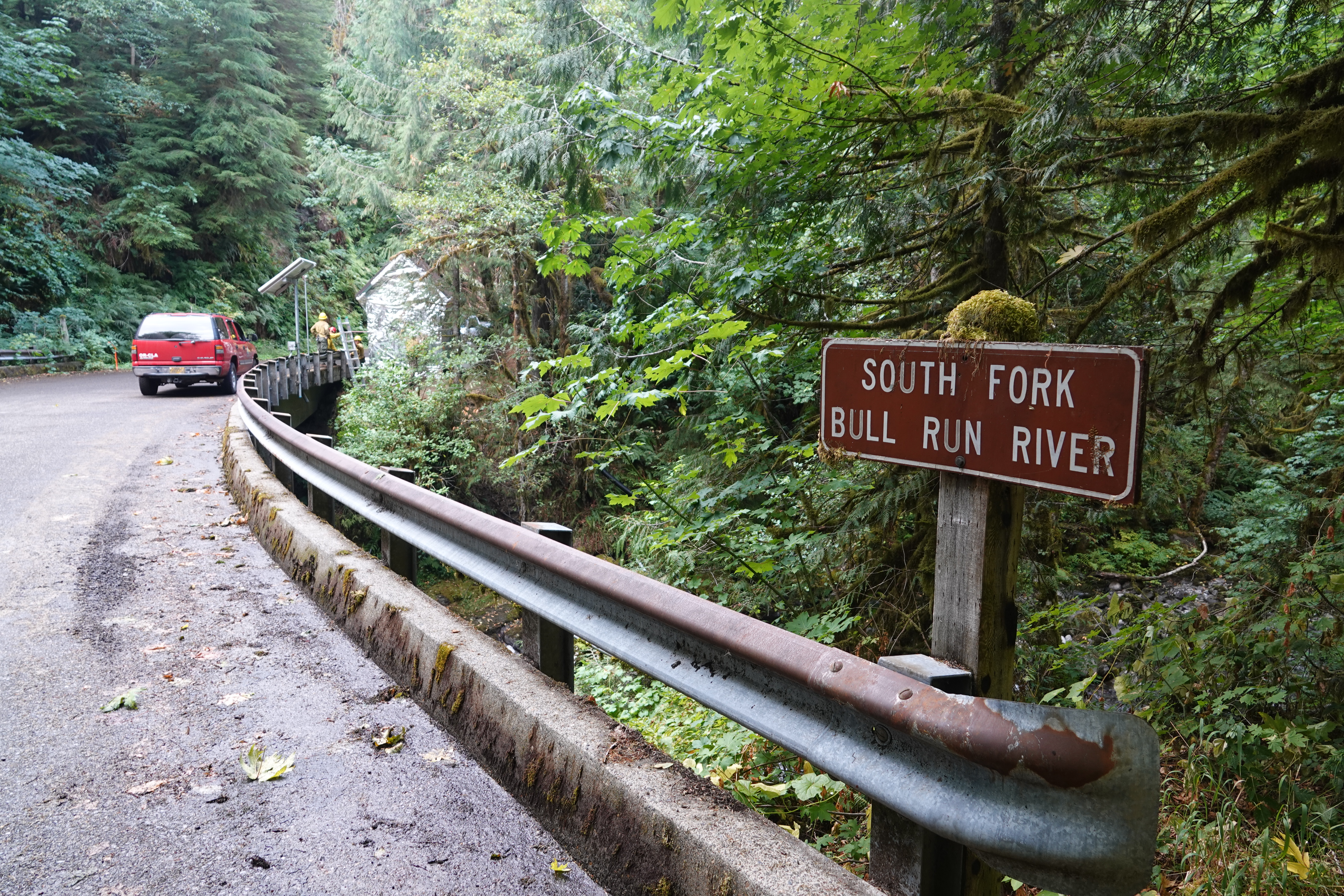
The Bull Run Watershed is an important source of drinking water for much of the greater Portland area. Access to the old growth forest is restricted in order to ensure the region’s drinking water remains clean and safe to drink. But those responsible for the water quality don’t just leave it to chance. This facility along the South Fork of the Bull Run River is a water sampling station.
The Camp Creek Fire has halted its advance nearby. But in case that changes and the building is threatened, firefighters took steps to protect it from flames. They covered the small structure with material like those used for the fire shelters they carry. Should fire activity increase and approach the building, the aluminized structure wrap will protect it from burning embers and radiant heat.
Four photos can be viewed below by clicking on the caption:
- Water sampling station along the South Fork of the Bull Run River, wrapped in order to protect it from fire.
- Water sampling station along the South Fork of the Bull Run River, wrapped in order to protect it from fire.
- U.S. Forest Service firefighter from the Columbia River Gorge National Scenic Area affixes aluminized structure wrap to a water sampling station in the Bull Run Watershed.
- Bridge on Forest Road 12 over the South Fork of the Bull Run River, with a water sampling station wrapped to protect it from fire.
Hurricane Fire Update August 31 2023
Related Incident: Hurricane Fire
Publication Type: News
For Immediate Release
Contact: Public Affairs Office, Olympic_PAO@nps.gov, 360-565-3005
Hurricane Fire holds at 3 acres following rainy and cloudy day
Port Angeles, Wash. - The Hurricane Fire did not grow following a rainy and cloudy day at Hurricane Ridge; fire suppression efforts made progress by establishing containment lines, laying a hose to the fire, and working to prevent rolling debris from causing additional fire spread. Aerial resources were not used today due to weather and poor visibility but are scheduled to be used tomorrow if weather allows.
The forecast going into the weekend calls for sunnier and drier conditions, which could promote fire growth. It will be closely monitored over the weekend.
Hurricane Ridge Road will remain closed on Friday, September 1, but that closure is being evaluated daily. Public and firefighter safety is the highest priority on the Hurricane Fire.
The fire is under a full suppression strategy and is currently being worked by a Type 2 initial attack hand crew, a Type 2 helicopter, a contracted water tender, and Olympic Fire Program staff. Aerial resources will be used when weather conditions allow. There are currently 30 personnel assisting with suppression efforts.
The Hurricane Fire was ignited on the afternoon of August 28, when a series of lightning strikes occurred on the Olympic Peninsula.
A reconnaissance flight is planned in the coming days to determine if there are any additional fire starts as a result of the recent lighting strikes. Flights have been delayed due to recent weather and low visibility.
The nearby Eagle Point Fire in the Obstruction Point area is approximately 1 acre in size. Due to cloud cover, the Eagle Point Fire was not visible today. No suppression actions have taken place due to steep and inaccessible terrain.
On August 18, Olympic National Park and Olympic National Forest implemented a total fire ban including charcoal fires. The move to Stage 2 fire restrictions is due to continued hot and dry conditions that are forecasted to continue at least through the end of October as dry conditions in the region persist.
Closures
The Hurricane Ridge Road is closed just past the Heart of the Hills entrance station for firefighter and public safety. Fire staff and park management are reviewing this closure daily. Visitors can still access the Heart of the Hills Campground. Lake Angeles and Heather Park Trails have reopened and are accessible. These trails are good options for visitors that want a strenuous hike that brings them into the mountain region of the park. For updates on road status and weather conditions please call 360-565-3131 or visit on the web at www.nps.gov/olym.
Obstruction Point Road and the trailhead will remain closed until further notice. Olympic National Park Wilderness Information Center (WIC) will be notifying backcountry permit holders who may be impacted by this closure. Any permit holders who plan to backpack via the Obstruction Point Trailhead should contact the WIC at 360-565-3100 or https://www.nps.gov/olym/planyourvisit/wic.htm.
Weather and Fire Behavior
Today’s weather called for rain and mostly cloudy skies with temperatures between 44 and 47 degrees. Winds remained below 10 mph. Friday and Saturday are calling for sunnier and drier conditions with highs in the 60s.
Smoke from the Hurricane and Eagle Point Fires may be visible depending on weather conditions.
Information for the Hurricane Fire can be found at: Hurricane Fire Information | InciWeb (wildfire.gov)
National Interagency Fire Center: https://www.nifc.gov
Olympic National Park information: www.nps.gov/olym
Olympic National Forest information: www.fs.usda.gov/olympic
State and county area burn bans: www.waburnbans.net
Perspectiva de Humo Smith River Complex 318 19
Related Incident: Smith River Complex
Publication Type: News
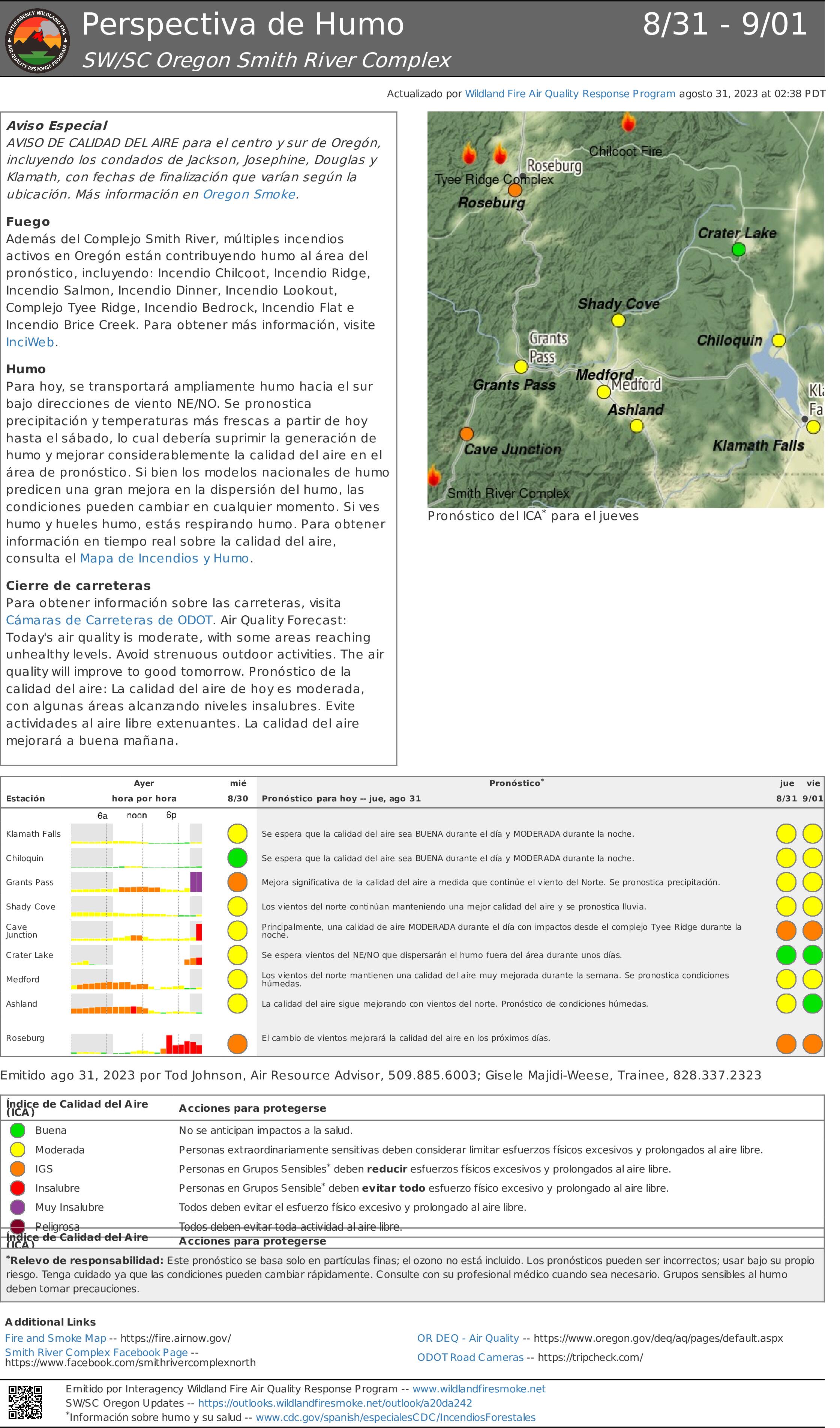
Aviso Especial
AVISO DE CALIDAD DEL AIRE para el centro y sur de Oregón, incluyendo los condados de Jackson, Josephine, Douglas y Klamath, con fechas de finalización que varían según la pubicación. Más información en Oregon Smoke.
Fuego
Además del Complejo Smith River, múltiples incendios activos en Oregón están contribuyendo humo al área del pronóstico, incluyendo: Incendio Chilcoot, Incendio Ridge, Incendio Salmon, Incendio Dinner, Incendio Lookout, Complejo Tyee Ridge, Incendio Bedrock, Incendio Flat e Incendio Brice Creek. Para obtener más información, visite InciWeb.
Humo
Para hoy, se transportará ampliamente humo hacia el sur bajo direcciones de viento NE/NO. Se pronostica precipitación y temperaturas más frescas a partir de hoy hasta el sábado, lo cual debería suprimir la generación de humo y mejorar considerablemente la calidad del aire en el
área de pronóstico. Si bien los modelos nacionales de humo predicen una gran mejora en la dispersión del humo, las condiciones pueden cambiar en cualquier momento. Si ves humo y hueles humo, estás respirando humo. Para obtener información en tiempo real sobre la calidad del aire, consulta el Mapa de Incendios y Humo.
Cierre de carreteras
Para obtener información sobre las carreteras, visita Cámaras de Carreteras de ODOT. Air Quality Forecast: Today's air quality is moderate, with some areas reaching unhealthy levels. Avoid strenuous outdoor activities. The air quality will improve to good tomorrow. Pronóstico de la
calidad del aire: La calidad del aire de hoy es moderada, con algunas áreas alcanzando niveles insalubres. Evite actividades al aire libre extenuantes. La calidad del aire mejorará a buena mañana.
Revised East Fire Closure Map and Order 83123
Related Incident:
Publication Type: Closures
Updated Map and Closure Order for the East Fire Closure Area 8/31/23
Level II evacuation level assigned to areas along the Elk River Road due to the Anvil Fire
Related Incident: Anvil Fire
Publication Type: Announcement
CURRY COUNTY SHERIFF’S OFFICE
SHERIFF JOHN WARD
CURRY COUNTY, OREGON
94235 MOORE STREET, SUITE 311
29808 Colvin Street (Physical)
GOLD BEACH, OR 97444
Regarding the Anvil Fire in the Grassy Knob Wilderness
In conjunction with the Fire Incident Management Team that is in charge of the Anvil Fire, northeast of Port Orford, Or., the Curry County Sheriff’s Office has decided to assign a Level II evacuation level to the areas along the Elk River Road from about milepost 4 to the USFS Butler Bar Camp Ground, located about twenty miles east of U.S. Highway 101 on Elk River Road. The increase of fire level is only precautionary due to the un-predictability of the fire behavior of the Anvil Fire. The Anvil Fire is a very difficult fire to fight due to the roadless wilderness area, very steep terrain, and heavily wooded thick old growth timber with a lot of fuel for the fire.
Again, this is only precautionary, and the Level II notice will be sent out over Everbridge to those who have signed up for Everbridge in that area. Curry County Sheriff’s Deputies will also go to all residences in the selected zone to provide the information. Remember, Level II is:
YOU MUST PREPARE TO LEAVE AT A MOMENTS NOTICE
“This level indicates there is significant danger to your area, and residents should either voluntarily relocate to a shelter or with family/friends outside of the affected area, or if choosing to remain, to be ready to evacuate at a moment’s notice.”
If you haven’t signed up for Everbridge Emergency Notices, you can go to the Curry County Webpage and sign up at co.curry.or.us. For any questions about Everbridge, you can call Ashley Thien in Emergency Management at 541 247-3275.
As your Sheriff, I want you to know that we will always make it a priority to protect you and your property as best we can. Stay safe and watch out for each other.
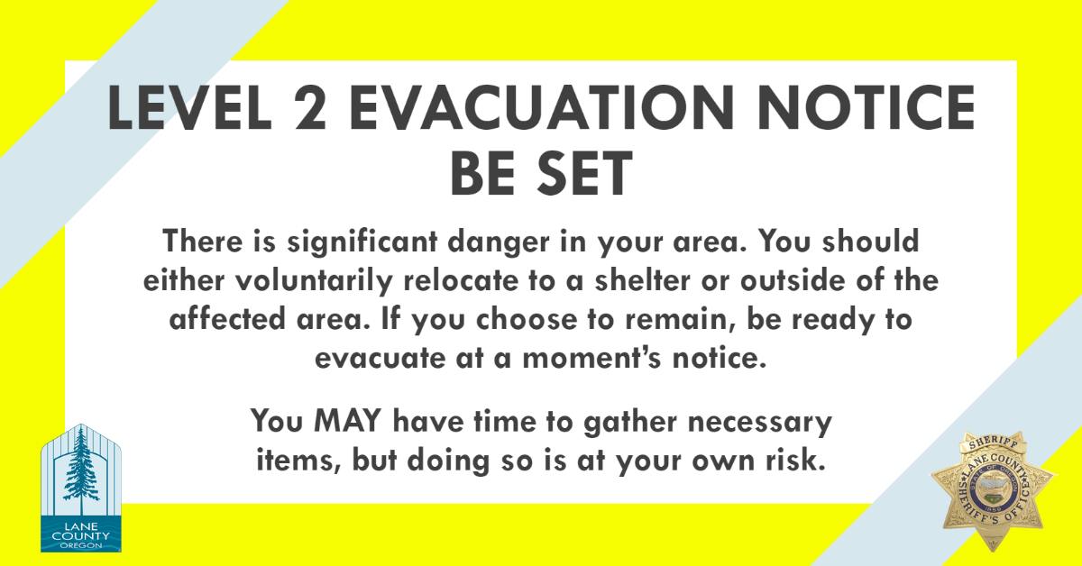
Level 2 Evacuation Notice Issued for Grizzly Fire by Lane County
Related Incident: Grizzly Fire
Publication Type: Announcement
Grizzly Fire Prompts Level 2 (Be Set) Evacuation Notice
Increased fire behavior on the Grizzly Fire, burning approximately 20 miles southeast of Dorena has prompted a Level 2 (Be Set) evacuation notice for the following areas:
All private lands & mining claims in the Bohemia areas within the Cottage Grove Ranger District of the Umpqua National Forest.
Level 2 means you must prepare to leave at a moment’s notice, and this may be the only notice that you receive. Public safety personnel cannot guarantee they will be able to notify you if conditions rapidly deteriorate.
--
This is the time for preparation and precautionary movement of persons with special needs, mobile property, pets and livestock.
An evacuation map is available at https://www.lanecounty.org/news/brice_dinner_grizzly_fires
Residents are encouraged to sign up for emergency alerts at www.LaneAlerts.org
--
The United States Forest Service has additionally implemented a forest closure for the entire Cottage Grove Ranger District.
 Grizzly 8-31.jpg?VersionId=MXbANEhZBAYG04WJCd2jROYOh84rcTep)
 Grizzly 8-31.jpg?VersionId=cItsgUH3x9hGlnP2nKfkoX4xn_8PKfBE)