
Montana Fish Wildlife Parks Reopens Flathead and Clark Fork Rivers in Sanders County Friday September 1
Related Incident:
Publication Type: Closures
Portions of the Flathead and Clark Fork rivers in Sanders County are reopened after being closed due to fire danger. Montana Fish, Wildlife & Parks is also reopening Kookoosint Fishing Access Site, Paradise Crossing Fishing Access Site, and Full Curl Wildlife Management Area south of Plains on Montana Highway 200.
FWP previously closed the stretches of rivers and access sites due to the River Road East fire. While conditions have improved, the fire continues to burn in the area, and recreationists are urged to be aware of fire conditions and weather.
All fire restrictions on FWP sites in northwest Montana are rescinded as well. Northwest Montana fire danger conditions have moderated and the threat of human caused fires growing out of control is reduced. Agencies are requesting the public to exercise caution with recreational campfires and continue to practice fire prevention throughout the remainder of summer and into the fall.
Fall hunters are reminded to drown all campfires with water and stir. Keep fires small and controllable. Never leave a campfire unattended. Completely extinguish all cooking and warming fires, even if you're leaving camp for a short period of time.
For the latest information on fires in Montana, visit https://www.mtfireinfo.org.
Happy Camp Complex Community Meeting in Horse Creek Sunday 530 pm
Related Incident: 2023 Happy Camp Complex Klamath NF
Publication Type: Announcement
There will be an in-person Community Meeting this Sunday, September 3, 2023 at 5:30 pm.
The meeting will be in the cafeteria at the Horse Creek Elementary School, 30438 Walker Road, Horse Creek, CA 96050.
Fire personnel and Klamath National Forest staff will provide an operational overview of the fire situation and answer questions from the community. All are welcome to attend!
TERMINATION of Salmo Basin Fire Closure
Related Incident: Salmo Basin Fire
Publication Type: Closures
TERMINATION OF ORDER
No. 06-21-35-23-04
COLVILLE NATIONAL FOREST
Colville National Forest Effective August 31st, 2023, Order No. 06-21-35-23-04 (Salmo Basin Fire Closure) dated August 9, 2023 is hereby terminated. Executed in Colville, Washington this 31st day of August 2023.
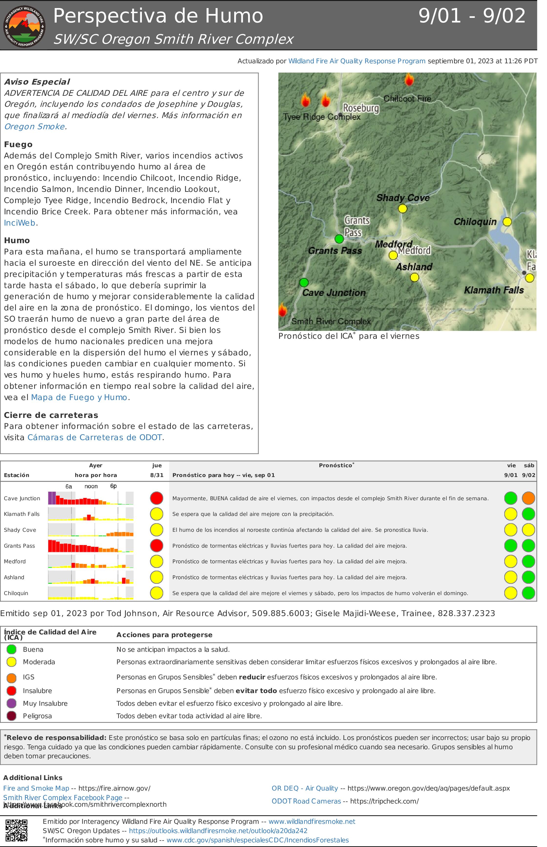
Perspectiva de Humo Smith River Complex 19 29
Related Incident: Smith River Complex
Publication Type: News
Aviso Especial
ADVERTENCIA DE CALIDAD DEL AIRE para el centro y sur de Oregón, incluyendo los condados de Josephine y Douglas, que finalizará al mediodía del viernes. Más información en Oregon Smoke.
Fuego
Además del Complejo Smith River, varios incendios activos en Oregón están contribuyendo humo al área de pronóstico, incluyendo: Incendio Chilcoot, Incendio Ridge, Incendio Salmon, Incendio Dinner, Incendio Lookout, Complejo Tyee Ridge, Incendio Bedrock, Incendio Flat y Incendio Brice Creek. Para obtener más información, vea InciWeb.
Humo
Para esta mañana, el humo se transportará ampliamente hacia el suroeste en dirección del viento del NE. Se anticipa precipitación y temperaturas más frescas a partir de esta tarde hasta el sábado, lo que debería suprimir la generación de humo y mejorar considerablemente la calidad del aire en la zona de pronóstico. El domingo, los vientos del SO traerán humo de nuevo a gran parte del área de pronóstico desde el complejo Smith River. Si bien los modelos de humo nacionales predicen una mejora considerable en la dispersión del humo el viernes y sábado, las condiciones pueden cambiar en cualquier momento. Si ves humo y hueles humo, estás respirando humo. Para obtener información en tiempo real sobre la calidad del aire, vea el Mapa de Fuego y Humo.
Cierre de carreteras
Para obtener información sobre el estado de las carreteras, visita Cámaras de Carreteras de ODOT
Tyee Ridge Complex Morning Update 090123
Related Incident: Tyee Ridge Complex
Publication Type: Announcement
Acreage: 6,674
Containment: 5%
Firefighters Productive in Favorable Weather
Umpqua, Ore. – The Tyee Ridge Complex fires had minimal growth in the last two operational periods. While firefighters continue to be engaged with active fire, the weather conditions enabled them to make direct attack, working safely on the fires edge. Overnight, crews faced new challenges with lack of visibility and wet road conditions. Oregon Department of Forestry crews to the north continued to secure lines and mop up. Crews on the Cougar Creek and Lighthouse Fires performed tactical firing operations of fuels within the fire line, identified contingency line options, and mitigated hazard trees.
Crews on the NW portion of the Cougar Creek Fire were able to establish hand lines between previously constructed dozer lines. Dozers and excavators were actively reinforcing lines for future use and continue to aid in structure protection. Protection of structures remains a high priority in the Hubbard Creek and Briarwood areas. Oregon State Fire Marshal structural task forces and hand crews are reinforcing lines around homes and continuing to mop up.
Today, the weather again offers favorable conditions allowing firefighters to go direct in some areas. Crews working the Lighthouse Fire will focus on preparing indirect lines for future burning on the difficult terrain to the west of the perimeter if needed. On the Cougar Creek Fire, firefighters to the SW are working along Bear Creek Road to keep a safe access point for personnel. On the SE portion crews will remain diligent in securing lines around homes and mopping up. Structure protection on Hubbard Creek Road will consist of hose lays on existing dozer lines and prepping structures to the south side. Air attack remains available to support control efforts and has set up of a mobile retardant base for future air operations.
There are significant changes to evacuation levels due to aggressive firefighting around homes by our structural and wildland crews. To view the current evacuation information map, go to www.dcso.com/evacuations. The Red Cross shelter for evacuees is now located at The Way Church of Sutherlin located at 1352 E. Central Ave. in Sutherlin, OR. To shelter livestock, contact Douglas County Animal Control at 541-440-4471. Companion pets can be sheltered at Saving Grace Pet Adoption Center in Roseburg.
Oregon Department of Forestry Team 1
Joe Hessel, Incident Commander
OSFM Red Team, Ian Yocum, Incident Commander
Settings - change map background and toggle additional layers
Filter - control incident types displayed on map.
Zoom to your location
Reset map zoom and position
Could not determine your location.
Show Legend
 Wildfire
 Prescribed Fire
 Burned Area
Response
Burned Area
Response Other
Other
Lions Camp Road Fire
Unit Information
Incident Contacts
Cowlitz Complex Fire Restrictions and Temporary Flight RestrictionsTFR
Related Incident: Cowlitz Complex
Publication Type: Announcement
Fire Restrictions: Fire Restrictions are in effect. Campfires are prohibited across the Gifford Pinchot National Forest – only propane-fueled fire pits, stoves and lanterns are allowed. Additional information is available on the forest’s website at Gifford Pinchot National Forest - Fire Management.
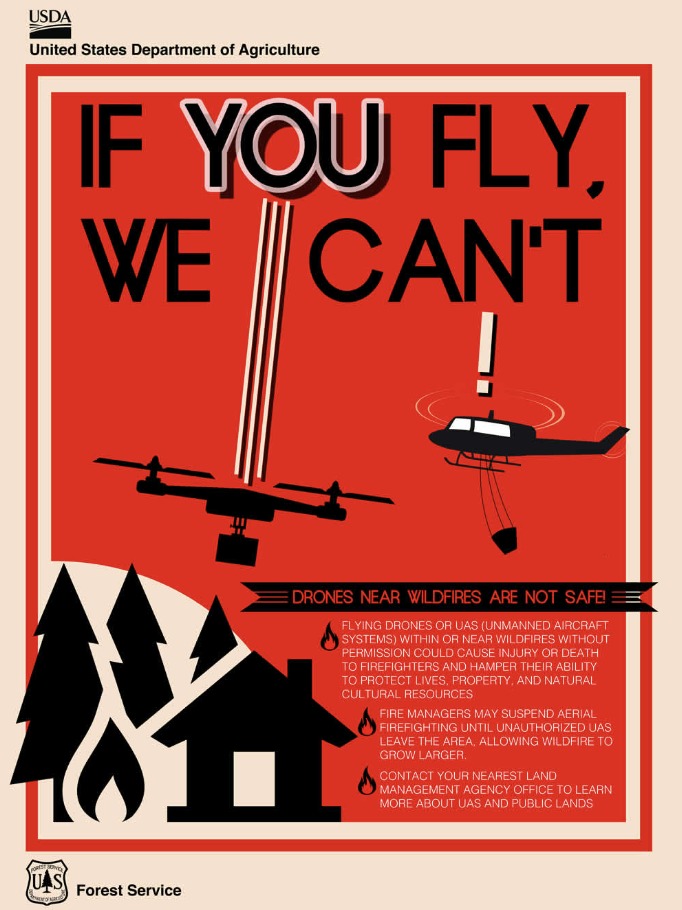
Temporary Flight Restrictions: Two TFRs are in effect, one located north of US-12 to Mount Rainier National Park, and a new TFR south of US-12 to include Snagtooth and Spencer Quartz. Fire aviation response is halted or delayed if an unauthorized aircraft enters the TFR. Temporary flight restrictions also apply to unmanned aircraft systems or drones. If you fly, we can’t! Learn more about how to use drones safely and responsibly at Home-Know Before you Fly.
Informacin actualizada para el Incendio Smith River Complex North viernes 1 de septiembre 2023
Related Incident: Smith River Complex
Publication Type: News
Información actualizada para el Incendio Smith River Complex North, viernes, 1 de septiembre, 2023
GRANTS PASS, Ore. – Debido a las posibilidades de tormentas con grandes cantidades de lluvias, el día de hoy, el Meteorólogo del Incidente, Jonathan Chriest, emitió un Aviso en la posibilidad de inundación repentina para el Incendio de Smith River Complex North. Se espera recibir hasta media pulgada de lluvia proveniente de algunas células de tormenta de movimiento lento. Las áreas de mayor peligro para inundaciones y flujo de escombros se encuentran a lo largo de Smith River, el área quemada en el incendio Slater y en las áreas afectadas recientemente por el incendio a lo largo del Hwy. 199 en California.
El jueves, se introdujeron en el área temperaturas frescas y un clima más húmedo. Este fenómeno logro moderar el comportamiento del incendio. La incrementación en la humedad ha limitado las operaciones de tácticas de quema en algunas partes del incendio. Las escuadrillas de bomberos se encuentran limpiando y asegurando las áreas que han sido quemadas en los últimos días en dichas operaciones. Se incluyen las líneas de fuego al Oeste de Gilligan Butte y a lo largo de las carreteras 4402 y 461. También, el jueves por la mañana, los recursos aéreos lograron dejar caer agua y retardantes cerca del área de Gilligan Butte y en otras áreas críticas. Esta labor sirvió de apoyo para los bomberos trabajando arduamente en el terreno. Mientras el sistema climático continue introduciéndose a mediados de la tarde del día de hoy y se observen nubes de baja altitud aunado a el humo cubriendo la zona del incendio, los recursos de aviación permanecerán en tierra hasta que se observen cambios favorables para seguir trabajando.
Anoche, se continuo con las operaciones de quema utilizando el Sistema Aéreo Automatizado (UAS, drones) en algunas zonas que aun no se han quemado y localizadas entre las carreteras 461 y 445. Una quema de baja intensidad en la misma área mencionada reducirá el peligro del incendio sobre la infraestructura al Este de O’Brien y a lo largo de Lone Mountain Road.
Las fuerzas de trabajo del Jefe de Bomberos para el estado de Oregon (OSFM) se encuentra laborando junto con los recursos de áreas silvestres con el único objetivo de asegurar las viviendas que se encuentran dentro de las comunidades en el Distrito de Incendio de Illinois Valley para minimizar de una manera estratégica las fuentes de material de combustión alrededor de la infraestructura. Tan pronto como se cumplan los objetivos de preparación de la infraestructura, las fuerzas de trabajo OSFM, iniciaran su extracción, regresando a su lugar de trabajo. Sin embargo, los recursos para la infraestructura silvestre permanecerán en pie. El miércoles, el personal de rapeles en Siskiyou, volaron hacia un área remota en el “pulgar” Noroeste del Incendio Smith River Complex. Este grupo especializado se dio a la tarea de explorar e improvisar 2 espacios para aterrizaje de helicópteros (helipuertos) así como también identificar puntos potenciales de anclaje para las líneas de incendio que se construyen con el propósito de reducir la propagación del fuego hacia el Noroeste dentro de las tierras vírgenes de Kalmiopsis.
Un Nivel de Evacuación 3 – SALGA permanece en pie para el Hwy. 199 al sur de O’Brien extendiéndose desde la milla 38 hasta la línea estatal. Un Nivel de Evacuación 2 – LISTOS ha sido emitido para O’Brien y el área de Takilma. Un Nivel de Evacuación 1 – PREPARESE fue dictado para el área al Norte de Cave Junction. La Cruz Roja Americana abrió un centro de albergue localizado dentro de Rogue Community College en Grants Pass. Los recursos pecuarios (ganado) pueden guarecerse en el Fairgrounds de Josephine County.
Debido a la actividad del incendio, se aconseja al público en general que revisen el sitio para el Manejo de Emergencia de Rogue Valley: https://rvem.org para información actualizada acerca de las evacuaciones. Asimismo, podrán encontrar un mapa señalando las áreas de Respuestas Iniciales de incendio.
El Bosque Nacional de Rogue River-Siskiyou ha implementado una Orden de Cierre de área y carretera para el Incendio Smith River Complex. Para mayor Información, visite: https://tinyurl.com/2s4hymku. La Oficina para el Manejo de Tierras (BLM) en Coos Bay ha anunciado un Cierre de Emergencia de tierras publicas cercanas a la frontera de Oregon/California. Para información más detallada visite: https://www.blm.gov/orwafire.
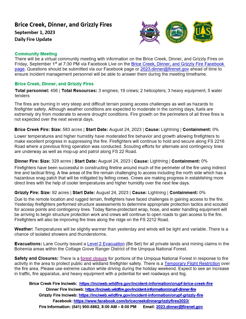
Brice Creek Dinner and Grizzly Fires Daily Update September 1 2023
Related Incident: Brice Creek FireGrizzly FireDinner Fire
Publication Type: News
Brice Creek, Dinner, and Grizzly Fires
September 1, 2023
Daily Fire Update
Community Meeting
There will be a virtual community meeting with information on the Brice Creek, Dinner, and Grizzly Fires on Friday, September 1st at 7:30 PM via Facebook Live on the Brice Creek, Dinner, and Grizzly Fire Facebook page. Questions should be submitted via our Facebook page or 2023.dinner@firenet.gov ahead of time to ensure incident management personnel will be able to answer them during the meeting timeframe.
Brice Creek, Dinner, and Grizzly Fires
Total personnel: 456 | Total Resources: 3 engines; 19 crews; 2 helicopters; 3 heavy equipment; 5 water tenders
The fires are burning in very steep and difficult terrain posing access challenges as well as hazards to firefighter safety. Although weather conditions are expected to moderate in the coming days, fuels are extremely dry from moderate to severe drought conditions. Fire growth on the perimeters of all three fires is not expected over the next several days.
Brice Creek Fire: Size: 583 acres | Start Date: August 24, 2023 | Cause: Lightning | Containment: 0%
Lower temperatures and higher humidity have moderated fire behavior and growth allowing firefighters to make excellent progress in suppressing the fire. Firefighters will continue to hold and secure along FS 2216 Road where a previous firing operation was conducted. Scouting efforts for alternate and contingency lines are underway as well as mop-up and patrol along FS 22 Road.
Dinner Fire: Size: 329 acres | Start Date: August 24, 2023 | Cause: Lightning | Containment: 0%
Firefighters have been successful in constructing fireline around much of the perimeter of the fire using indirect line and tactical firing. A few areas of the fire remain challenging to access including the north side which has a hazardous snag patch that will be mitigated by felling crews. Crews are making progress in establishing more direct lines with the help of cooler temperatures and higher humidity over the next few days.
Grizzly Fire: Size: 92 acres | Start Date: August 24, 2023 | Cause: Lightning | Containment: 0%
Due to the remote location and rugged terrain, firefighters have faced challenges in gaining access to the fire. Yesterday firefighters performed structure assessments to determine appropriate protection tactics and scouted for access points and contingency lines. Today flame-protectant wrap, hose, and water handling equipment will be arriving to begin structure protection work and crews will continue to open roads to gain access to the fire. Firefighters will also be improving fire lines along the ridge on the FS 2212 Road.
Weather: Temperatures will be slightly warmer than yesterday and winds will be light and variable. There is a chance of isolated showers and thunderstorms.
Evacuations: Lane County issued a Level 2 Evacuation (Be Set) for all private lands and mining claims in the Bohemia areas within the Cottage Grove Ranger District of the Umpqua National Forest.
Safety and Closures: There is a forest closure for portions of the Umpqua National Forest in response to fire activity in the area to protect public and wildland firefighter safety. There is a Temporary Flight Restriction over the fire area. Please use extreme caution while driving during the holiday weekend. Expect to see an increase in traffic, fire apparatus, and heavy equipment with a potential for wet roadways and fog.
Brice Creek Fire Inciweb: https://inciweb.wildfire.gov/incident-information/orupf-brice-creek-fire
Dinner Fire Inciweb: https://inciweb.wildfire.gov/incident-information/orupf-dinner-fire
Grizzly Fire Inciweb: https://inciweb.wildfire.gov/incident-information/orupf-grizzly-fire
Facebook: https://www.facebook.com/bricecreekdinnergrizzlyfires2023/
Fire Information: (541) 900-5862, 8:00 AM – 7:00 PM Email: 2023.dinner@firenet.gov
Ridge Doris Point and Tin Soldier Fires Daily Update Sept 1 2023
Related Incident:
Publication Type: News
Ridge Fire
Location: 6 miles southeast of Hungry Horse
Size: 3665 acres
Percent Contained: 76%
Cause: Lightning
Start Date: July 30th, 2023 @ 3:45 PM
Personnel Assigned: 219
Flathead NF Fire Restrictions Lifted & Hungry Horse Closure
Order Amended for Ridge, Doris Pt, and Tin Soldier Fires
September 1st, 2023 Daily Update
Doris Point Fire
Location: 8 miles south of Hungry Horse
Size: 1606 acres
Percent Completed: 98%
Cause: Lightning
Start Date: July 30th, 2023 @ 3:45 PM
Personnel Assigned: 16
Tin Soldier Fires
Location: 17 miles east of Swan Lake
Size: 8165 acres
Percent Completed: 94%
Cause: Lightning
Start Date: July 30th, 2023 @ 3:45 PM
Personnel Assigned: 84
Highlights:
Yesterday the Flathead National Forest announced changes to the closure order for Hungry Horse Reservoir. Please follow the links below for information regarding access to the area. Forest users are encouraged to watch out for fire personnel and equipment on the roadways and working in the area. The new closure order for the west side of the reservoir will be enforced. Additionally, fire restrictions were lifted for the Flathead National Forest. A type 3 team will assume command of the fire on Tuesday.
Operations:
Ridge and Doris Point Fires:
Yesterday the repair group worked on pulling in berms on contingency lines west and north of the Ridge Fire. The other divisions of the fire were inaccessible due to the rain event from the previous day. Crews will finish their repair missions today. On the Doris Point Fire ground resources backhauled pumps and hose, as well as identified sprinkler system locations and input them into a mapping database for future use by local fire managers. Firefighters also cut additional hazard trees around Lost Johnny Point resulting from the most recent storm system. Today crews will continue with those missions and monitor some heat sources on the south end of the fire.
Tin Soldier Fire:
Yesterday ground resources assessed road systems in need of improvement and began road grading from the horse corrals near Spotted Bear Ranger Station moving north. Road grading will continue today along FS RD 895 across the bridge over the South Fork Flathead River. An excavator will begin repair of the fire line along Meadow Creek with crews working in the same area repairing hand line. Additionally, firefighters will clean up tree debris on roadways from the mechanical thinning and log skidding project along Meadow Creek. Smoldering fire activity is expected on the Bruce Fire.
Weather and Fire Behavior:
The weak ridge of high pressure will continue to build over the region today through Saturday. Temperatures will warm another 10 degrees compared to yesterday with southeasterly winds. Thermal belts will start to build each night.
Ridge, Doris Point, and Tin Soldier Fires: 78-83° in the lower elevations and 68-73° in the mid-slopes to ridges with minimum relative humidity at 30-35%. Winds on the Ridge and Doris Point Fires will be southeast 5-10 mph. On the Tin Soldier Fires winds will be southeast 5-10 mph with gusts to 15 mph.
The Hungry Horse Reservoir closure order changed to allow access to the east side of the reservoir and on the west side down to the Doris Point Boat Launch. The lake is now open for boating. The closure remains in place on the west side of the reservoir as firefighter presence remains, however the mandatory evacuation order for the Heinrude Community has been lifted. Residents of the Heinrude community need to contact the Hungry Horse Ranger Station at (406) 387-3800 to arrange access to their properties. For the most current information regarding evacuation status please visit https://flathead.mt.gov/department-directory/oes/emergency-management/ridge-fire-information. As firefighting efforts continue on the Ridge Fire, Doris Point Fire, and Tin Soldier Fire the closure is in place to provide for public and firefighter safety. https://www.fs.usda.gov/alerts/flathead/alerts-notices/?aid=82283
Additional Information:
Residents should stay alert for changing conditions and visit https://www.ready.gov/wildfires for preparing for wildfires. Information for the Ridge, Doris Point, and Tin Soldier Complex Fires is found at https://inciweb.nwcg.gov/incident-information/mtfnf-ridge-fire.
Fire Information: 406-998-6074 (8:00 am to 7:00 pm)
Email: 2023.ridge@firenet.gov
https://www.facebook.com/ridge.fire.information https://www.youtube.com/@2023ridgefire