
Ridge Doris Point and Tin Soldier Fires Daily Update Sept 2 2023
Related Incident:
Publication Type: News
Fire Managers Support new fire start and utilize equipment from the Ridge, Doris Pt, and Tin Soldier Fires
September 2nd, 2023 Daily Update
?????, ????? ?????, ??? ??? ??????? ???? ????? ?????? - ????????? ?, ????
????? ????:
Location: 6 miles southeast of Hungry Horse
Size: 3665 acres
Percent Contained: 76%
Cause: Lightning
Start Date: July 30th, 2023 @ 3:45 PM
Personnel Assigned: 226
????? ????? ????:
Location: 8 miles south of Hungry Horse
Size: 1606 acres
Percent Completed: 98%
Cause: Lightning
Start Date: July 30th, 2023 @ 3:45 PM
Personnel Assigned: 16
??? ??????? ?????:
Location: 17 miles east of Swan Lake
Size: 8165 acres
Percent Completed: 94%
Cause: Lightning
Start Date: July 30th, 2023 @ 3:45 PM
Personnel Assigned: 50
Highlights:
There was a small fire reported yesterday, located on the 2847 road, in between the Tin Soldier complex fires. The lighting started fire is called the Soldier Fire. It is a single tree that is being handled by the local forest engines. The Tin Soldier Complex fire managers are supporting the local unit with any equipment needs.
Operations:
Ridge and Doris Point Fires:
The areas on the Northeast side of the Ridge fire are drying out and becoming accessible for firefighters to complete the repair work on the existing handlines. The repair work and the backhaul of pumps and hose are close to completion. Doris Point Campground project work is nearing completion as well. The areas around the campground are being assessed to ensure there are no hazards left behind, including fire weakened trees, when that area is turned back over to the local unit.
Tin Soldier Fire:
Road grading will continue along FS RD 895 near the bridge over the South Fork Flathead River. Crews, with the assistance of an excavator, are finishing the repair of the fire and hand line along Meadow Creek. Additionally, firefighters continue to clean up tree debris from the mechanical thinning and log skidding project along roadways in the Meadow Creek area. Fire managers are working closely with the local resource advisors to make sure that the repair plan lines up with what works best for resources that were impacted in the suppression efforts. Smoldering fire activity is expected on the Bruce Fire with minimal smoke being seen from the area.
Weather and Fire Behavior:
Today is expected to be sunny and warm. The warm weather will continue the drying trend and produce minimal smoke from the Bruce Fire.
Winds on the Ridge and Doris Point Fires will be southeast 5-10 mph. On the Tin Soldier Fires winds will be southeast 5-10 mph with gusts to 15 mph.
Fire Closure:
The Hungry Horse Reservoir closure order has been modified to allow access to the east road of the reservoir and on the west road down to the Doris Point Boat Launch. The lake is now open for recreation. The closure remains in place on the west side of the reservoir as firefighter presence remains. The Heinrude Community evacuation level has been lifted but residents but due to the forest closure, residents need to contact the Hungry Horse Ranger Station at (406) 387-3800 to arrange access to their properties.
For the most current information regarding evacuation status please visit https://flathead.mt.gov/.../emerge.../ridge-fire-information. As firefighting efforts continue on the Ridge Fire, Doris Point Fire, and Tin Soldier Fire the closure is in place to provide for public and firefighter safety. https://www.fs.usda.gov/alerts/flathead/alerts-notices/...
Additional Information:
Residents should stay alert for changing conditions and visit https://www.ready.gov/wildfires for preparing for wildfires. Information for the Ridge, Doris Point, and Tin Soldier Complex Fires is found at https://inciweb.nwcg.gov/incident.../mtfnf-ridge-fire.
???? ???????????: 406-998-6074 (8:00 am to 7:00 pm)
?????: 2023.ridge@firenet.gov
Informacin al da para el Incendio Smith River Complex North sbado 2 de septiembre 2023
Related Incident: Smith River Complex
Publication Type: News
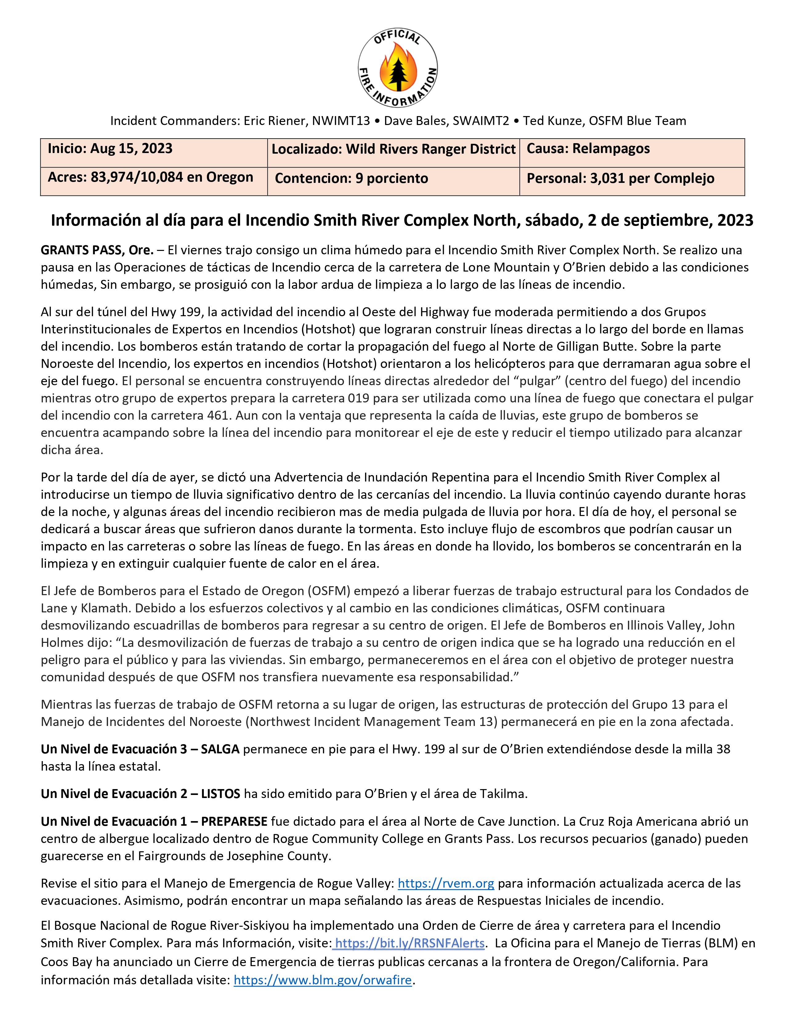
Información al día para el Incendio Smith River Complex North, sábado, 2 de septiembre, 2023
GRANTS PASS, Ore. – El viernes trajo consigo un clima húmedo para el Incendio Smith River Complex North. Se realizo una pausa en las Operaciones de tácticas de Incendio cerca de la carretera de Lone Mountain y O’Brien debido a las condiciones húmedas, Sin embargo, se prosiguió con la labor ardua de limpieza a lo largo de las líneas de incendio.
Al sur del túnel del Hwy 199, la actividad del incendio al Oeste del Highway fue moderada permitiendo a dos Grupos Interinstitucionales de Expertos en Incendios (Hotshot) que lograran construir líneas directas a lo largo del borde en llamas del incendio. Los bomberos están tratando de cortar la propagación del fuego al Norte de Gilligan Butte. Sobre la parte Noroeste del Incendio, los expertos en incendios (Hotshot) orientaron a los helicópteros para que derramaran agua sobre el eje del fuego. El personal se encuentra construyendo líneas directas alrededor del “pulgar” (centro del fuego) del incendio mientras otro grupo de expertos prepara la carretera 019 para ser utilizada como una línea de fuego que conectara el pulgar del incendio con la carretera 461. Aun con la ventaja que representa la caída de lluvias, este grupo de bomberos se encuentra acampando sobre la línea del incendio para monitorear el eje de este y reducir el tiempo utilizado para alcanzar dicha área.
Por la tarde del día de ayer, se dictó una Advertencia de Inundación Repentina para el Incendio Smith River Complex al introducirse un tiempo de lluvia significativo dentro de las cercanías del incendio. La lluvia continúo cayendo durante horas de la noche, y algunas áreas del incendio recibieron mas de media pulgada de lluvia por hora. El día de hoy, el personal se dedicará a buscar áreas que sufrieron danos durante la tormenta. Esto incluye flujo de escombros que podrían causar un impacto en las carreteras o sobre las líneas de fuego. En las áreas en donde ha llovido, los bomberos se concentrarán en la limpieza y en extinguir cualquier fuente de calor en el área.
El Jefe de Bomberos para el Estado de Oregon (OSFM) empezó a liberar fuerzas de trabajo estructural para los Condados de Lane y Klamath. Debido a los esfuerzos colectivos y al cambio en las condiciones climáticas, OSFM continuara desmovilizando escuadrillas de bomberos para regresar a su centro de origen. El Jefe de Bomberos en Illinois Valley, John Holmes dijo: “La desmovilización de fuerzas de trabajo a su centro de origen indica que se ha logrado una reducción en el peligro para el público y para las viviendas. Sin embargo, permaneceremos en el área con el objetivo de proteger nuestra comunidad después de que OSFM nos transfiera nuevamente esa responsabilidad.”
Mientras las fuerzas de trabajo de OSFM retorna a su lugar de origen, las estructuras de protección del Grupo 13 para el Manejo de Incidentes del Noroeste (Northwest Incident Management Team 13) permanecerá en pie en la zona afectada.
Un Nivel de Evacuación 3 – SALGA permanece en pie para el Hwy. 199 al sur de O’Brien extendiéndose desde la milla 38 hasta la línea estatal.
Un Nivel de Evacuación 2 – LISTOS ha sido emitido para O’Brien y el área de Takilma.
Un Nivel de Evacuación 1 – PREPARESE fue dictado para el área al Norte de Cave Junction. La Cruz Roja Americana abrió un centro de albergue localizado dentro de Rogue Community College en Grants Pass. Los recursos pecuarios (ganado) pueden guarecerse en el Fairgrounds de Josephine County.
Revise el sitio para el Manejo de Emergencia de Rogue Valley: https://rvem.org para información actualizada acerca de las evacuaciones. Asimismo, podrán encontrar un mapa señalando las áreas de Respuestas Iniciales de incendio.
El Bosque Nacional de Rogue River-Siskiyou ha implementado una Orden de Cierre de área y carretera para el Incendio Smith River Complex. Para más Información, visite: https://bit.ly/RRSNFAlerts. La Oficina para el Manejo de Tierras (BLM) en Coos Bay ha anunciado un Cierre de Emergencia de tierras publicas cercanas a la frontera de Oregon/California. Para información más detallada visite: https://www.blm.gov/orwafire.
Cowlitz Complex Update September 2 2023
Related Incident: Cowlitz Complex
Publication Type: News
Rocky Mountain Area Complex Incident Management Team Two
Jared Hohn, Incident Commander
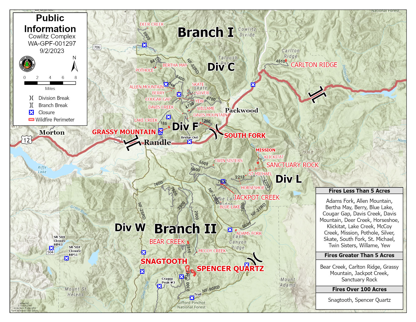
Current Situation: A total of 444 personnel are currently assigned to the Cowlitz Complex, which is 5% contained and encompasses a total of 646 acres. The word of the day is “safety”. The Cowlitz Complex encompasses a vast area of the Gifford Pinchot National Forest, with hundreds of firefighters equally dispersed. The timing of this incident brings added safety concerns occurring during the Labor Day holiday weekend, as well as berry and mushroom picking season, and the Packwood Flea Market. All of this concurrent activity has brought heavy traffic to roads paved and unpaved throughout the area. Please travel slowly in congested areas in town and on the forest. Be sure that parked vehicles are well off of roadways to allow passage by fire trucks and other large vehicles.
The dense forest and steep terrain are impediments to firefighter safety. Fire weakened trees and those with root rot are at risk of falling even under light windy conditions. Crews also need to be alert for potential rolling logs and other debris on steep slopes.
The conditions make for difficult access into and out of several of the individual fires, making extraction difficult in the event of an injury. Yesterday’s break in cloud cover allowed aerial reconnaissance flights to allow an overview of more remotely located fires that are less easily accessed on the ground. Aerial observers saw a few small wisps of smoke. As fuels dry out today, additional smoke may become evident.
In Branch 1/Division C, planning is taking place that could allow firefighters to move into the Deer Creek Fire, about 2.7 miles north of Forest Road 52, near Glacier View Trailhead. Yesterday, rappelers were inserted on the Berry Fire, located on Allen Mountain, about 8 miles north of Randle.
In Branch 2/Division L, additional rappelers dropped into the Sanctuary Rock Fire, located 11.5 miles south of Packwood near St. John Lake. Road access was opened up to the Bear Creek Fire, located 17 miles south of Randle on McCoy Peak, so that crews can begin taking suppression action.
Fire Restrictions: Fire Restrictions are in effect. Campfires are prohibited across the Gifford Pinchot National Forest – only propane-fueled fire pits, stoves and lanterns are allowed. Additional information is available on the forest’s website at Gifford Pinchot National Forest - Fire Management (usda.gov).
Weather & Smoke Information: Weather is expected to be mostly clear again this morning, with temperatures climbing into the 80s in the valley, cooler at higher elevations. Relative humidity will be lower today, dropping to around 35%. Some thunderstorm activity is expected in the southern end of the fire area, which may bring some scattered showers in the afternoon and overnight tonight.
Closures: In anticipation of ongoing fire activity in the vicinity of the Snagtooth Fire the following roads and trails will be closed to the public to reduce exposure and help ensure public safety: Forest Roads 9300 and 9341 (currently off limits), Boundary Trail #1(from Elk Pass to intersection with Summit Prairie), Summit Prairie #2, Craggy Peak #3, Snagtooth #4, Quartz #5, Stabler Camp #17, Wright Meadows #80, Basin Camp #3 A, Quartz #5 B, Quartz #5 C (French Creek), Snyder Pasture #80 A. Forest Road 8410 is closed for firefighter and public safety in the vicinity of the Pothole Fire.
Temporary Flight Restrictions: A temporary flight restriction (TFR) is in effect over the fire area between U.S. Highway 12 and Mount Rainier National Park. Fire aviation response is halted or delayed if an unauthorized aircraft enters the TFR. Temporary flight restrictions also apply to unmanned aircraft systems or drones. If you fly, we can’t! Learn more about how to use drones safely and responsibly at Home - Know Before You Fly.
Smoke Outlook 92 93 Smith River Complex
Related Incident: Smith River Complex
Publication Type: News
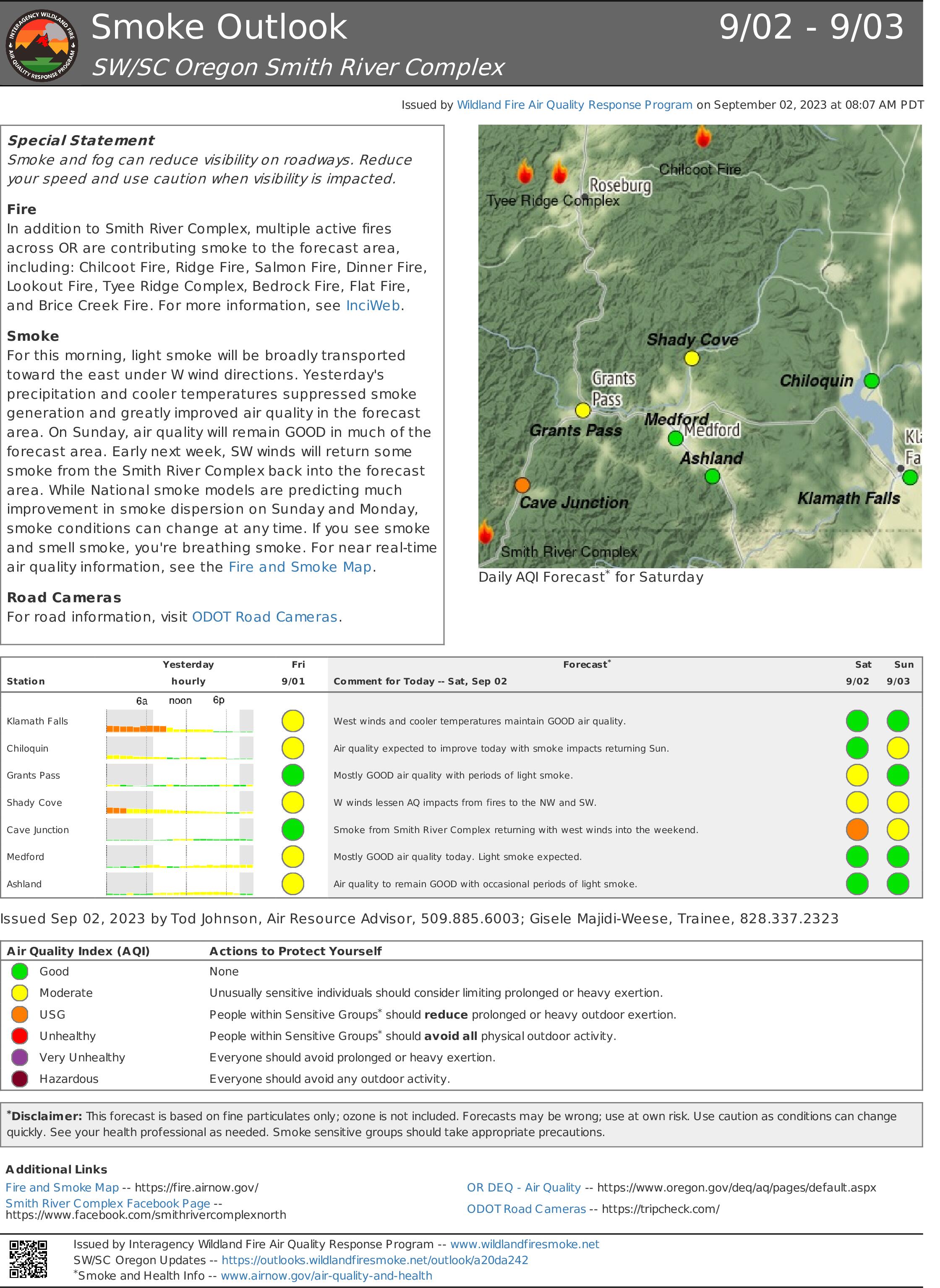
Special Statement
Smoke and fog can reduce visibility on roadways. Reduce your speed and use caution when visibility is impacted.
Fire
In addition to Smith River Complex, multiple active fires across Oregon are contributing smoke to the forecast area, including: Chilcoot Fire, Ridge Fire, Salmon Fire, Dinner Fire, Lookout Fire, Tyee Ridge Complex, Bedrock Fire, Flat Fire, and Brice Creek Fire. For more information, see InciWeb.
Smoke
For this morning, light smoke will be broadly transported toward the east under west wind directions. Yesterday's precipitation and cooler temperatures suppressed smoke generation and greatly improved air quality in the forecast area. On Sunday, air quality will remain GOOD in much of the forecast area. Early next week, southwest winds will return some smoke from the Smith River Complex back into the forecast area. While National smoke models are predicting much improvement in smoke dispersion on Sunday and Monday, smoke conditions can change at any time. If you see smoke and smell smoke, you're breathing smoke. For near real-time air quality information, see the Fire and Smoke Map.
Road Cameras
For road information, visit Oregon Department of Transportation Road Cameras.
Tyee Ridge Complex Morning Update 090223
Related Incident: Tyee Ridge Complex
Publication Type: Announcement
Acreage: 6,674
Containment: 15%
Containment Ticks Up on Tyee Ridge Complex
Umpqua, Ore. –Firefighting and favorable weather resulted in evacuation levels being reduced across the complex of fires. Fire perimeters on all fires have shown no growth in the last 24 hours. Roads remain closed in the Hubbard Creek area, but residents can now return to their homes with proof of residency.
Night crews continued to prepare for future tactical firing operations and put in direct line where the fire can be accessed safely. Firefighters on the SE perimeter of the Cougar Creek fire established fire line from Bear Creek Road to Bear Creek and opened roads to safely reach the fire. On the north end of the Cougar Creek Fire, crews continue to establish containment lines towards Cougar Creek. All crews continue to mop up, address smoldering areas and larger fuel flare ups.
The Oregon State Fire Marshal and Oregon Department of Forestry crews are using handheld Infrared cameras to locate hotspots around structures and on the fire line. These devices allow firefighters to quickly identify and address hotspots during mop up operations and structure protection.
Today, the weather again offers favorable conditions, with potential for more rain, up to a quarter of an inch in localized areas. As fire behavior is now mostly creeping and smoldering, crews will take advantage during day operations by establishing direct line where possible and mop up in all areas. On the southern portion of the Cougar Creek Fire, crews are scouting locations for contingency lines. Structure protection on Hubbard Creek Road will consist of wrapping structures, installing hose lays, using handheld infrared units to identify hotspots, and mop up operations. Air attack remains available to support control efforts.
The Douglas County Sherriff’s Office has reduced evacuation levels and removed the remaining Level 3 (Go Now!). To view the current evacuation information map, go to www.dcso.com/evacuations. The Red Cross shelter will be closing today at 12 PM. To shelter livestock, contact Douglas County Animal Control at 541-440-4471. Companion pets can be sheltered at Saving Grace Pet Adoption Center in Roseburg.
Oregon Department of Forestry Team 1
Joe Hessel, Incident Commander
OSFM Red Team, Ian Yocum, Incident Commander
Ridge Creek Fire Update Saturday September 2 2023
Related Incident:
Publication Type: News
Location: Approximately 3.5 miles east of the north tip of Hayden Lake, along the Hayden Creek Road (Forest Service Road 437) from the Ridge Creek drainage to South Chilco Mountain.
Start Date: 8/3/2023 Cause: Human-caused Size: 4,474 acres Containment: 51%
Total Personnel: 270 Heavy Equipment: 10 Engines: 6 Crews: 7
Note: All fire restrictions have been lifted for the Idaho Panhandle National Forest. While campfires are no longer restricted, hunters and recreationists are urged to continue to use caution. Never leave a campfire unattended, and make sure it is cold to the touch before walking away. Please visit https://www.idl.idaho.gov/fire-management/fire-restrictions-finder for a detailed map and current information regarding fire restrictions across the state.
With weekend traffic increasing, motorists are advised to watch for firefighting equipment as firefighters released from the incident travel home.
FIRE STATUS
The Ridge Creek Fire was reported on 8/3/23 at 2:30 pm in the Ridge Creek drainage, approximately three miles east of the northern tip of Hayden Lake. Investigators have determined that the fire was human-caused.
Yesterday, firefighters continued to monitor and patrol the fire’s edge, mop up hot spots, chip along roads and make repairs to roads and other features damaged by fire suppression. A grader completed work on the 209 Road to Bumblebee Campground. The Hudlow Warming Hut spike camp has been broken down and removed. Firefighters removed pumps and hoses from an area burned out with tactical firing operations near Sage Creel Saddle as that area has been mopped up. Chipping operations increased in the Bunco Road area with the addition of another chipper.
Today’s work focus is on suppression repair across the footprint of the fire area. According to Operations Section Chief Shawn Nagle, suppression repair work will “turn the fire area back to the way we found it”.
Suppression repair includes removing brush along fire lines and chipping it and grading roads and installing water bars on them to prevent erosion. Completion of this work will allow opening of roads and areas to the public. Because opening roads on the northern side of the fire is a priority, three chippers and two crews will work along Bunco Road today. Air operations include removing temporary repeaters installed for firefighter communications.
To the southwest heavy equipment continues to work on the 206 Road, as well as chippers on the 625 Road. Initial attack firefighters continue to be available to respond to new fire starts in the surrounding area.
The Southern Area Gold Incident Management Team will transition to a local Type 3 Incident Management Team tomorrow.
WEATHER AND FIRE BEHAVIOR
A slight warming trend is expected today and a slight chance of showers return to the area on Sunday. Temperatures are expected to be a high of near 77-82 degrees and a low near 55, and winds are forecast to be southwest 3-6 mph, increasing to west 8 to 12 mph after 10 am. Relative humidity is expected to be 33-38 percent.
Air quality information is available at www.airnow.gov and www.wildlandfiresmoke.net.
“Only four heat signatures were seen on the IR [infrared] flight last night,” said Fire Behavior Analyst Kelly Cagle. “That’s pretty minimal.” Live and dead vegetation remains damp from recent rainfall and active flames are unlikely. With a drying trend, some areas of smoke may appear where built-up organic material or large logs smolder, especially in areas with remaining heat at the northeast portion of the fire.
CLOSURES AND SPECIAL MESSAGES
Kootenai County has lifted all evacuation notices. Please monitor official county sources for the most up-to-date information. https://www.kcsheriff.com/186/Emergency-Management
A daylight hours temporary flight restriction remains in place. Information is available at https://tfr.faa.gov/save_pages/detail_3_3347.html
Closure Order #01-04-03-23-003 for the Idaho Panhandle National Forest remains in place for Forest Service land north of Forest Service Road (FSR) 206, west of FSR 209 and FSR 385, and south of FSR 332; and for Forest Service land surrounding and north of the Yellowbanks Creek area and west of FSR 1535.
The closure includes all Forest Service Roads within the area:
- FSR 332, 385, 392, 428A, 437, 1507, 1511, 1530, 1552 and 1587.
- FSR 206 north of the junction with FSR 406.
- FSR 406 north of the junction with FSR 206.
- Bunco Road/FSR 332 from the National Forest boundary east to the junction of FSR 385.
- FSR 385 from the junction with Bunco Road/FSR 332 south to the junction of FSR 209 and FSR 794.
It also includes Forest Service Trails 69, 78, 234, 577 and 802.
This order is necessary for public and firefighter safety due to heavy fire traffic and equipment in the area. For more information, please see the Idaho Panhandle National Forest website at Idaho Panhandle National Forests - Alerts & Notices (usda.gov)
2023 SRF Lightning Complex and Redwood Lightning Complex Update Saturday 90223
Related Incident: 2023 SRF Lightning Complex and Redwood Lightning Complex
Publication Type: News
Fire Update
2023 Six Rivers National Forest Lightning Complex & Redwood Lightning Complex
Saturday, September 2, 2023 – 9:00 a.m.
Rocky Mountain Complex Incident Management Team 1
Dan Dallas, Incident Commander
Information Phone: 530-536-0767
Email: 2023.lightningcomplex@firenet.gov
Information Staffing Hours: 8 am to 8 pm
Current Situation: Rocky Mountain Complex Incident Management Team 1 assumed command of the incident consisting of 19 fires at 6:00 am this morning. The Hancock Fire has been transferred to the Klamath Complex for logistical efficiency. The 19 fires on this incident total 16,478 acres and overall containment is 20%. Please note we have a new Facebook page at www.facebook.com/2023SRFRedwoodLightning .
Redwood National and State Parks Area Fires
Bridge Ridge (17 acres), Devil (12 acres) and Glen (0.1 acres) are 100% contained and in mop up and patrol status.
Lost – 55% contained, 722 acres. A combination of direct and indirect suppression tactics are being utilized to contain the fire between the mainstem and middle forks of Lost Man Creek and Holter Ridge. CALFIRE is assisting to keep this fire as small as possible.
Hoopa Area Fires
Lone Pine – 90% contained, 1,684 acres. Unused hoseline is being rehabbed and returned to supply.
Orleans and Somes Bar Area Fires
Pearch – 4,486 acres. Firing operations utilizing the Unmanned Aerial System (UAS) continue. Structure Protection crews are working 24-hour shifts, while Structure Assessment Teams have been assessing structures in the Somes Bar area. Firefighters continue to use full suppression strategies to protect values at risk including human life, communities, cultural improvements, and critical infrastructure.
Mosquito – 2,447 acres. Fire activity is minimal and mop up operations are in progress.
Bluff #1 – 1,993 acres. There is very minimal fire activity and mop up continues today.
Creek (8 acres), Flat (2 acres), Iron (20 acres), Blue Creek 0.1-acres), Big Foot (0.8 acres) are all 100% contained and in patrol status.
Monument (2 acres), Merrill Mountain (2 acres), Blue Creek 2 (2,898 acres), Marlow (1,491 acres), Let er-Buck (73 acres), Copper (619 acres) are currently unstaffed due to difficult terrain, firefighter safety, and other higher priority fires.
Evacuations: There are evacuation warnings in the areas listed below, but no actual evacuations currently. Anyone in an evacuation warning area should be prepared for potential evacuations, including packing personal supplies, and arranging overnight accommodations. Be ready to go at a moment's notice.
Pearch Fire Evacuation Warnings: Zone HUM-E009 (Southeast of the Klamath River in Orleans); Zone HUM-E008-B (Community of Orleans, west of Klamath River. East of Crawford Creek, including Orleans proper). Hwy 96 and Red Cap Road along the east bank of Klamath River, south from Salmon River, east to Orleans Mountain. Approximately 243 residents live in these two zones.
Siskiyou County Evacuation Warnings: Zone SIS-1701: NORTH of Monte Creek Road, SOUTH OF Camp Three Road, EAST OF Camp Three Road, WEST OF Wooley Creek Trailhead. Also zones SIS-1402, SIS-1515, and SIS-1518.
Weather: Clouds and showers will persist across the region today. There is a slight chance for a few thunderstorms especially along the ridges that could bring gusty and erratic winds. Rainfall amounts will generally be less than 0.25 inches. Temperatures will be in the mid-60s to low 70s.
Closures
Six Rivers National Forest: Area and campground closures are in effect on portions of Six Rivers National Forest. They can be found at: https://www.fs.usda.gov/detail/srnf/notices/?cid=FSEPRD1096395 .
Redwood National Park and State Park: There are multiple closures in the parks due to several fires, including closures in the Lost Man area. For a full list of closures and impacts, please visit: www.nps.gov/redw/planyourvisit/conditions.htm .
Alert Notifications
ZoneHaven/Genasys for map and zone identification: https://protect.genasys.com .
Humboldt County Residents Register for Humboldt Alert Notification: www.humboldt.gov/alerts
Siskiyou County Resident Register at Code Red Alert Notification: https://public.coderedweb.com/CNE/en-US/6F327CCDFFFD .
Fire Information Contacts
Phone: 530-536-0767 | Email: 2023.lightningcomplex@firenet.gov
InciWeb: https://inciweb.nwcg.gov/incident-information/casrf-2023-srf-lightning-complex
Facebook: www.facebook.com/2023SRFRedwoodLightning
Redwood National and State Parks Information Hotline: Phone: 707-464-6101
https://www.nps.gov/redw/planyourvisit/conditions.htm
Hoopa Information Hotline: Phone: 530-618-2995 | Email: serene.oes@gmail.com
More Fire Information Links: www.linktr.ee/srffirepio
Petes Lake Fire Update September 2 2023
Related Incident: Petes Lake Fire
Publication Type: News
Resources: 219 Total Personnel | 2 Hand Crews | 3 Dozers | 4 Helicopters |15 Engines | 5 Masticators | 2 Water tenders
Central Oregon – The Petes Lake Fire was started by a lightning strike on Friday, August 25, near the border of the McKenzie River Ranger District of the Willamette National Forest and the Bend Fort-Rock Ranger District of the Deschutes National Forest in the Mink Lake Basin area of the Three Sisters Wilderness. The footprint of the fire currently remains on the Willamette National Forest. The fire is burning five miles west of Elk Lake and is 318 acres in size.
Smoke jumpers, hotshots, and firefighters initially engaged directly with the fire in the rugged and remote terrain of the Wilderness area. Helicopters transported firefighters, supplies, and dropped water on the fire, but dense smoke limited consistent aviation support. Because firefighter and public safety are the top priority, the decision was made to employ the Cascade Lakes Highway as a control feature. The last of the smokejumpers hiked out of the Mink Lake Basin yesterday. Since direct attack of this fire is currently not a viable option, firefighters are focusing on protecting values at risk such as structures, campgrounds, and other recreation sites.
Yesterday: Firefighters continued to thin vegetation to improve the shaded fuel break along the Cascade Lakes Highway. Shaded fuel breaks thin dense tree stands to reduce fire's intensity while retaining enough shade to slow down ground fire. Skidders were employed to remove dead-and-down woody debris along the highway. Firefighters chipped brush and small trees that had been removed along the highway between Lava Lake and Elk Lake. Fire managers implemented partial lane closures to mitigate the risk to firefighters working along the roadway and allow for more efficient work on the fuel break. The structure protection team continued to assess and document structures to the east of the shaded fuel break and refine plans for structure protection.
Today: Fire crews and heavy equipment operators will be working to improve the shaded fuel break along the highway near Elk Lake. With more equipment arriving, the improvements to the fuel break along the highway continue to support control features for this and potential future fire activity.
Weather: Yesterday, the fire did not receive precipitation as predicted, but cooler temperatures and higher relative humidity continued to moderate fire behavior. Today, intermittent showers are predicted along with thunderstorms and the potential for lightning. The amount of precipitation expected is not enough to extinguish the fire. Fire managers say that a “season ending” weather event, such as sustained heavy rain or snow, is needed to extinguish this fire.
Evacuations: The Deschutes County Sheriff lifted the Level 1 Evacuation Notice for the areas east of the Cascade Lakes Highway. The Level 3 (Go Now) Evacuation Notice is still in place for all areas west of the Cascade Lakes Highway from the Lucky Lake Trailhead north to the Mirror Lake Trail. This includes the areas around Lucky Lake, Leech Lake, Doris Lake, Blow Lake and Mirror Lakes. Yesterday, the Deschutes County Sheriff’s Office lifted the Level 1 (Be Ready) Evacuation Notice for Elk and Lava Lakes. Evacuation notices and updates can be found at: www.deschutes.org/emergency.
Closures: The closure order on the Willamette and Deschutes National Forests for the Petes Lake Fire remains in place and can be found at: fs.usda.gov/detail/deschutes/news-events/?cid=FSEPRD1134682.
Resorts along the Cascade Lakes Highway remain open for business, though visitors may encounter delays with road flaggers and pilot cars.
Safety: The public is asked to use caution and follow all signage, flaggers, and pilot cars when driving along the Cascade Lakes Highway. The public can help prevent new wildfires by observing current public fire use restrictions and avoiding other common ignition causes.
2 de septiembre 2023 Informacin al da para el Incendio Flat y Incendio Anvil
Related Incident: Flat FireAnvil Fire
Publication Type: News
Se ha creado una página especifica en Inciweb para el Incendio Anvil. Visite: bit.ly/AnvilFireOR
Actividad en el Incendio Flat .
Extensión: 34,242 acres Fecha de Inicio: 15-Julio-2023 Origen: 2 millas Sureste de Agness, OR
Contencion: 58% Personal: 416
Recursos: 5 escuadrillas de bomberos, 6 helicópteros, 14 camiones de bomberos, 9 cisternas, 12 piezas de equipo pesado
Los bomberos continúan seleccionando y retornando a su lugar de origen el equipo que se encuentra alrededor del incendio, incluyendo sistemas de riego, mangueras, bombas y tanques de agua. La escuadrilla de bomberos que trabajan a mano y los operadores de las excavadoras se encuentran caminando los senderos para extraer las líneas alternativas de maquinaria pesada y aumentando el numero de zanjas (water bars) como una medida de prevención en el proceso de erosión del terreno afectado. Se continua con las actividades de astillado al final del lado Sureste localizadas a lo largo de la carretera Forestal 109. Una vez concluida dicha labor, la maquinaria de astillado será utilizada en otras áreas alrededor del Incendio. Los bomberos se encuentran patrullando y monitoreando alrededor del fuego, observando detenidamente la línea que no ha sido contenida al Este del perímetro. Se podrá observar la presencia del humo entre las líneas mientras se queman espacios con material de combustión en el interior de este. Los recursos para Ataque Inicial están posicionados y listos para asistir al bosque de cualquier forma que sea necesaria.
Actividad en el Incendio Anvil.
Extensión: 135 acres Fecha de Inicio: 25 de agosto, 2023 Origen: 8 millas al Este de Port Orford, OR
Contención: 0% Personal: 119
Recursos: 4 escuadrillas de bomberos, 1 helicóptero, 4 camiones de bomberos, 3 cisternas, 1 pieza de equipo pesado
La estrategia para el Incendio Anvil se basa en mantener el fuego lo más pequeño posible. Sin embargo, debido a las pendientes pronunciadas, el tipo de terreno accidentado y el peligro que representa la presencia de árboles muertos por la acción de las llamas, los bomberos han decidido evaluar otras opciones para atacar al incendio. Estas alternativas incluyen ataques directos (línea de distancia creada desde el eje del incendio con alta posibilidad de éxito y un riesgo mínimo para los bomberos) e indirectos (construcción de líneas sobre el eje del incendio), y puntos de protección. El día de hoy, si las condiciones del clima lo permiten, se conducirá un vuelo de reconocimiento para identificar crestas en la montaña las cuales podrían ser utilizadas para líneas de control alternativas. Las escuadrillas de bomberos han empezado evaluaciones a lo largo de las carreteras de Elk River y Sixes River con el objetivo de identificar la infraestructura y determinar puntos de protección necesarios. Este trabajo podría incluir la eliminación de vegetación y material de combustión situado alrededor de las viviendas y el resto de la infraestructura en el área y posicionando sistemas de riego con mangueras y bombas de agua. Los dueños de propiedades podrán notar la presencia de los bomberos en estas áreas. Los recursos aéreos continuaran apoyando a los bomberos mientras las condiciones lo permitan.
Condiciones climáticas: El día de ayer, cayo cierta humedad en ambos incendios. El clima permanecerá fresco con alto porcentaje de humedad para los próximos días. Sin embargo, el grado de temperatura se incrementará poco a poco para la próxima semana dándose un decrecimiento en el nivel de humedad, y como resultado un crecimiento potencial en el comportamiento del incendio.
Condiciones de humo: La información de la perspectiva del humo para el Incendio de Smith River Complex y los otros incendios a su alrededor, incluyendo el incendio Flat, puede ser encontrado en: https://tinyurl.com/smokeoutlook. Por la tarde de hoy, la precipitación y las temperaturas frescas deberán suprimir la generación de humo e improvisará la calidad del aire. Para el domingo, los vientos del Suroeste lograran regresar el humo dentro del área pronosticada para el clima.
Ordenes de Cierres: El U.S. Highway 199 ha sido cerrado al Norte de Gasquet debido a incendios en el Bosque Nacional de Six Rivers, por favor use la ruta U.S. Route 101 hacia SR 42s para viajar hacia y desde Rogue Valley. Las carreteras del Servicio Forestal y BLM no deberán ser utilizadas como rutas alternativas debido a la actividad de surgimiento de incendios en la zona. El Bosque Nacional de Rogue River-Siskiyou ha declarado una orden de cierre incluyendo senderos, caminos y una porción del área de Illinois River. Información acerca los cierres en el área del Incendio pueden encontrarse en: https://bit.ly/RRSNFAlerts.
Evacuaciones: Se encuentra en pie niveles de evacuación Nivel 1 “Prepárese” para todas las áreas en las proximidades del Incendio Flat. Un Nivel 2 “Listos” se ha dictado para el área a lo largo de Elk River desde la Milla 4 hasta el Campamento Buttler Bar del Servicio Forestal y cercano al incendio Anvil. Para más información acerca de los incendios y para registrarse en el Sistema de Alertas, visite: https://bit.ly/CurryCoEM
Orden de restricción: Actualmente, se encuentra vigente el Nivel 3 en las Restricciones para el Uso Público (PURs). Para mayor informacion visite https://bit.ly/RRSNFAlerts. Se implemento una orden temporal de restricción de vuelos (TFR) sobre las áreas de incendios. Se le pide al publico en general que por favor no vuelen equipos automatizados (drones) en la zona aledaña al incendio. “Si Usted vuela, nosotros no Podemos”.
How Mop Up Aids in Containment
Related Incident: Camp Creek Fire
Publication Type: News
As we start showing more containment on the Camp Creek Fire — indicated by a black line along the perimeter of the map — you may begin reading the phrase “mop up” in our daily updates or hearing it mentioned in our recorded videos. Mop up refers to a stage of firefighting to help remove any remaining heat along a containment line.
When you properly put out a campfire, you are essentially mopping up. Smokey Bear and fire prevention officers let people know they need to do more than just put water on a campfire to extinguish it. Instead, campers are instructed to pour water on the remaining ash and debris, stir it in, and repeat the process until there is no heat remaining. This is the same process firefighters use on a much larger scale.
Crews use a variety of tools and water sources to patrol the outer edge of the fire, working their way farther into the burned area to check for any heat sources that could produce or blow embers outside of the containment line. A nearby engine can serve as a water source, or a small portable pump can draw water from an adjacent pond or creek. Firefighters drag hoses through the area, feeling for heat, breaking up burned logs, and wetting any vegetation or ash that still feels hot. They also may carry a specialized backpack that can hold five gallons of water and has a small sprayer attached. They check tree stumps for heat, break up or trench logs that could roll outside the containment line, and stir and drown any hot areas that are still smoking. Sawyers may even fell snags or trees because of the danger they may topple and spread heat.
Mop up can last for days after the last active flames along the control line have died down. While completely extinguishing all material burning within the entire fire’s interior is impractical on large fires, firefighters instead focus on an area within a specified distance from the control line.