
Brice Creek Dinner and Grizzly Fires Daily Update September 3 2023
Related Incident: Brice Creek FireDinner FireGrizzly Fire
Publication Type: News
Brice Creek, Dinner, and Grizzly Fires
September 3, 2023
Daily Fire Update
Brice Creek, Dinner, and Grizzly Fires
Total personnel: 599 | Total Resources: 11 engines; 24 crews; 2 helicopters; 3 heavy equipment; 4 water tenders
Firefighters are taking advantage of the cooler temperatures and higher humidity to develop safe and methodical plans for engaging the Grizzly Fire in this difficult terrain. Fire behavior has been minimal and the fires have had no growth over the past few days. Challenges including inaccessible, steep terrain, and numerous snags that take significant time and effort to mitigate.
Brice Creek Fire: Size: 583 acres | Start Date: August 24, 2023 | Cause: Lightning | Containment: 15%
Hotshots completed hand line on the western flank yesterday and tied it into FS 2216 Road, effectively halting growth on the north and west fire perimeters. Primary fireline improvement along FS 22 Road continues today to prepare for tactical firing operations when conditions allow. Firefighters will resume the important but tedious mop-up process in deep duff and heavy downed wood, adding depth to firelines.
Dinner Fire: Size: 304 acres | Start Date: August 24, 2023 | Cause: Lightning | Containment: 30%
Successful mop-up work yesterday helped to further secure the fire perimeter and contributed to an increase in containment. Today crews are still working to mitigate snags to gain better access to areas of the fire to expand upon mop-up operations. (Small decrease in acreage due to more accurate mapping.)
Grizzly Fire: Size: 92 acres | Start Date: August 24, 2023 | Cause: Lightning | Containment: 0%
Due to the remote location and rugged terrain, firefighters face continued challenges in gaining access to the fire. Yesterday, sprinkler kits, flame-resistant wrap, and water handling equipment arrived to continue structure protection operations. Crews scouted potential areas for direct fireline in areas that are largely inaccessible by vehicles and encountered numerous challenges that posed a serious risk to firefighter safety that could not be mitigated. Today, additional scouting for primary lines will resume as well as structure protection work as fire crews begin setting up sprinkler systems and wrapping structures. Smokejumpers will work on wrapping the historic Fairview Peak Lookout and Musick Guard Station.
Weather: Temperatures will be slightly cooler than yesterday, with winds from the west-northwest gusting to 15 mph. There is a chance of showers in the late afternoon.
Evacuations: Lane County issued a Level 2 Evacuation (Be Set) for all private lands and mining claims in the Bohemia areas within the Cottage Grove Ranger District of the Umpqua National Forest.
Safety and Closures: There is a forest closure for portions of the Umpqua National Forest in response to fire activity in the area to protect public and wildland firefighter safety. There is a Temporary Flight Restriction over the fire area. Please use extra caution while driving this holiday weekend. Expect to see an increase in traffic, fire apparatus, and heavy equipment with a potential for wet roadways and fog.
Brice Creek Fire Inciweb: https://inciweb.wildfire.gov/incident-information/orupf-brice-creek-fire
Dinner Fire Inciweb: https://inciweb.wildfire.gov/incident-information/orupf-dinner-fire
Grizzly Fire Inciweb: https://inciweb.wildfire.gov/incident-information/orupf-grizzly-fire
Facebook: https://www.facebook.com/bricecreekdinnergrizzlyfires2023/
Fire Information: (541) 900-5862, 8:00 AM – 7:00 PM Email: 2023.dinner@firenet.gov
Smith Complex Fire South Zone Daily Update September 3 2023
Related Incident: Smith River Complex
Publication Type: News
September 3, 2023 Smith River Complex- South Daily Update
Start Date: Aug 15, 2023
Location: Six Rivers National Forest
Cause: Lightning
Acres: 84,802
Containment: 12%
Personnel: 2,969
Highlights: US-199 opened to all traffic on Saturday, September 2, 2023. Caltrans and CHP are piloting traffic between Patrick Creek and Oregon Mountain Road. Fire personnel, Caltrans, and construction crews are actively working along the road; continue to use caution and drive slowly. Be aware that fire operations are ongoing, the Smith River Complex is active, and conditions could change.
The Del Norte County Sheriff’s Office, in collaboration with the Del Norte County Office of Emergency Services, lowered the evacuation level in the Oregon Mountain Road Area and the Sun Star Evacuation Zone to Level 2. Repopulation of these communities began on September 2.
An Interactive Evacuation Map is available to keep residents informed on current evacuation levels.
Operations: Fire behavior is expected to gradually increase in scale, duration, and intensity over the next several days. The most active growth potential is expected to be on the Coon Fire as is closes the gap to Forest Road 405 and along Bear Basin Road for the Kelly Fire. The Hurdy Gurdy Fire is expected to continue to progress toward Bear Basin Road, continue flanking west along Fox Ridge Road, and continue slowly backing downslope east toward the Smith River.
Weather and Fire Behavior: Minimal precipitation fell over the fire area Saturday night. A warming, drying trend will begin Sunday. Fire activity will gradually increase, but significant growth is not anticipated.
Smoke and Air Quality: Expect smoke where the fire has moved into burn scars from previous wildfires: Biscuit (2002), Bear and Coon (2015), Eclipse (2017), and Slater (2020). Air quality information is available at www.airnow.gov.
Safety: Del Norte Sheriff’s Office is asking residents to refrain from unnecessary travel. Local roads will be very active with firefighters and firefighting apparatus, especially between 6:30 AM and 8:30 AM.
Area and Road Closures: Closures will be adjusted based on fire activity. All county roads within the closure area remain closed and are patrolled by law enforcement.
Evacuations: Evacuation orders are issued by the Del Norte County Sheriff's Office. If you are in the Del Norte County area, please sign up for their Community Alert System to receive emergency notifications. Current evacuations are on the Interactive Evacuation Map.
LEVEL 3 : “Go Now”: Rockland
LEVEL 2: “Be Set”: Rowdy Creek/Low Divide, Gasquet, Big Flat/Rock Creek, Little Jones/Washington Flat Residential Areas, Patrick Creek Lodge, Oregon Mountain Road Area, Sun Star
LEVEL 1 :“BeReady” Hiouchi
Fire Information: 2023.smithrivercomplex@firenet.gov
Facebook: www.facebook.com/SixRiversNF
Camp Creek Fire Update for Sunday September 3
Related Incident: Camp Creek Fire
Publication Type: News
Weather and Fire Behavior:
Temperatures are forecasted to reach 65 degrees this afternoon in the fire area followed by an 80% chance of light showers after 8 p.m. Winds may reach a high of 15 miles per hour and move from the southwest to a northeasterly direction. Weather is expected to get warmer and drier moving into next week with little chance of precipitation.
The fire’s fuels (timber, moss and duff) are continuing to respond to the drier conditions. However, this will also dry out small sticks and tree litter which may produce more small pockets of flames. This will help firefighters achieve their firing operation objectives, which is when they burn off small pockets of vegetation to reduce the amount of available fuel along the fire’s perimeter to help with fire containment.
Fire weakened trees and snags that fall suddenly without warning continue to be a major hazard to firefighters. Due to the increased holiday traffic, firefighter safety while driving with crews and heavy fire equipment is a concern. Please be cautious of crews and heavy equipment transportation on the road.
Operations:
Firefighting crews will continue to reinforce firelines and conduct firing operations when the right conditions are in place. They will also ensure critical structure protection of assets like a county repeater site, the Bull Run water treatment plant, and a SNOTEL weather station.
Yesterday, an uncrewed aircraft system (UAS) crew arrived to help the incident management team. The UAS will provide a better day-to-day view of the fire through a live video camera feed and more detailed acreage reporting via infrared mapping. It can also help with aerial firing operations in steep terrain to provide better control of fire behavior. This process is known as aerial ignitions and is further explained here on the Camp Creek Fire InciWeb.
Today, fire information officers will be stationed at Mt. Hood Foods in Rhododendron, OR., and Safeway in Sandy, OR, from 1 – 6 p.m. to provide fire information and answer questions in-person.
Additional Information:
Current smoke outlook: https://outlooks.wildlandfiresmoke.net/outlook/2c7a8f9b
Closures and Evacuations:
Barlow Wayside Park and the Sandy Ridge Recreation Site is temporarily closed due to fire activity. To receive critical emergency messaging via email, phone call, or text, Clackamas County residents can by sign up at https://www.clackamas.us/dm/publicalerts
Temporary Flight Restriction (TFR): There is a TFR over the fire area, which includes public drone use. If you fly, we can’t – illegal drone use in a TFR area can halt critical air resource support on the fire putting homes, infrastructure, and other values at risk.
Videos:
The link below takes you to a morning video update by Operations Section Chief Matt Call:
Morning video update for Sunday, September 3
River Road East Fire Daily Update Sunday September 3
Related Incident:
Publication Type: News
River Road East Fire
Fact Sheet
Sunday, September 3, 2023 at 10:00 am
NORTHERN ROCKIES TEAM 1
INCIDENT COMMANDER: BRENT OLSON
Information Phone: 406-345-5972
https://inciweb.nwcg.gov/incident-information/mtlnf-river-road-east-fire
Email: 2023.RiverRoadEast@firenet.gov
Facebook: https://www.facebook.com/riverroadeastfire
Location: 6 miles southeast of Plains, Montana
Start Date: 8/18/2023 Cause: Unknown Size: 17,310 acres Containment: 54%
Total Personnel: 308 Crews: 7 Engines: 14 Helicopters: 3
KEY MESSAGE: Fire suppression repair is work done immediately following fire suppression actions to repair damages and minimize potential soil erosion and related impacts from the suppression actions. Suppression repair usually begins after a segment of containment line has held for several days and before the fire is fully contained. The repair work is completed on hand and dozer fire control lines, roads, trails, staging areas, safety zones, and drop points that were used during fire suppression efforts.
CURRENT STATUS: Yesterday, crews continued to monitor the containment lines along the north side of the fire above Henry’s Creek and around Henry’s Peak as well as around the northeast corner and along the eastern flank of the fire following the Lolo National Forest and CSKT boundary. No heat or smoke was observed along these containment lines. Direct control line work was completed by crews on the southeast corner of the fire where areas of heat near the line continued to be worked on by the crews. Containment and control lines were patrolled and monitored by crews on the northwest corner. On the west flank the Heavy Equipment Task Force continued to slowly work their way out of the area on the forest road coming down from Pat’s Knob. The indirect control line shaded fuels break is in place on the west side and ready to be used if needed. On the southwest corner crews continued to work on constructing the fuels break as well as some hot spotting along the fire edge.
PLANNED ACTIONS: Crews will continue to monitor the northern, northeastern corner, and eastern containment lines where little to no fire activity has been seen along the fire edge. This includes the Henry’s Creek and Henry’s Peak areas as well as the forest and CSKT boundary. The southeastern corner of the fire will be patrolled and monitored throughout the day. Over on the northwest and west sides of the fire crews will patrol and monitor for any heat or smoke along the control line. The crews will continue working on an indirect control line on the southwest corner of the fire and might be able to finish that line in a couple of days. There are indirect control lines constructed on the west (north of Pat’s Knob), southwest, and southeast sides of the fire. These indirect lines will remain in place if needed this fall. Crews will start working on some fire suppression repair on a few small sections of hand constructed control line along the north side of the fire.
WEATHER: The weather will be mostly cloudy with a slight chance of rain. Temperatures will be 70-80 degrees in the valleys and 63-73 degrees on the ridges. Minimum relative humidity levels will be 39-49% in the valleys and 54-64% on the ridges. Winds will be from the west at 5-15 mph on the ridge tops and from the southwest at 5-15 mph at lower elevation.
CLOSURES: The Lolo National Forest has an emergency closure of roads and trails (Closure #23-010-Lolo-D5) effective August 21, 2023. This Order is for public and firefighter safety during fire suppression efforts of the River Road East Fire. For a complete listing of the closed roads & trails visit: https://www.fs.usda.gov/alerts/lolo/alerts-notices.
3 de septiembre 2023 Informacin al da para el Incendio Flat y Incendio Anvil
Related Incident: Flat FireAnvil Fire
Publication Type: News
Actividad en el Incendio Flat
Extensión: 34,242 acres Inicio: 15-Jul-2023 Origen: 2 millas al Sur de Agness, OR
Contencion: 70% Personal: 421
Recursos: 5 escuadrillas de bomberos, 3 helicópteros, 12 camiones de bomberos, 12 cisternas, 12 maquinaria pesada
El incendio Flat actualmente se encuentra contenido a un 70%. El día de ayer se efectuó un vuelo de reconocimiento confirmándose que el incendio permanece en su lugar de origen. Sin embargo, se continúa quemando material de combustión y existe un potencial de que se vuelva a quemar el área que aun contiene vegetación con hojas secas. En el lado que aun no se ha contenido el incendio, se recibieron lluvias hasta de media pulgada y granizo sobre el área Este. Para el día de hoy, los bomberos seguirán aprovechando las condiciones favorables del clima, enfriando espacios calientes profundizándose más el interior del incendio.
Se prosigue con el patrullaje, monitoreo y trabajos de supresión alrededor del perímetro. Recursos de Ataque inicial se encuentran organizados y listos para asistir al bosque en lo que sea necesario.
Actividad en el Incendio Anvil
Extensión: 299 acres Inicio: 25 de agosto, 2023 Origen: 8 millas al Este de Port Orford, OR
Contención: 0% Personal: 120
Recursos: 4 escuadrillas de bomberos, 1 helicóptero, 5 camiones de bomberos, 2 cisternas, 1 pieza de equipo pesado
Se recibió menos cantidad de lluvia en el Incendio Anvil que en el Incendio Flat. Sin embargo, se está dando un arrastre del fuego y la producción del humo debido a la reciente precipitación, a temperaturas frescas y al porcentaje de humedad más alto.
El día de ayer, las condiciones del tiempo hicieron imposible realizar un vuelo de reconocimiento sobre el Incendio Anvil. En cuanto las condiciones lo permitan, se intentará nuevamente el llevar a cabo esta operación. Además, el día de ayer por la tarde, el grupo de Expertos en Incendios (Hotshots) de la Agencia Interinstitucional de Winema logro volar un dron recolectando datos infrarrojos con la meta de obtener datos más exactos acerca del tamaño del Incendio. Se espera cierto crecimiento de este, producido por el despliegue de material de combustión, pero de una forma limitada gracias a las condiciones climáticas. Despliegue de material de combustión significa cuando los troncos, arboles quemados y otros escombros ruedan cuesta abajo. Esta acción puede causar la iniciación de fuegos y representa un peligro significativo para la seguridad de los bomberos. Se podría incrementar la actividad del fuego después del fin de semana cuando las temperaturas se calienten y aunado a las condiciones secas en la zona. Los manejadores del Incendio continúan estudiando opciones para construir líneas indirectas (creación de líneas de fugo a una distancia del eje del fuego con alta probabilidad de éxito y un bajo riesgo para los bomberos) y ataque directo (se refiere a la construcción de líneas de fuego sobre el eje de este) así como puntos de protección. Las escuadrillas de bomberos se encuentran evaluando y empezando a tomar medidas para puntos de protección a lo largo de las carreteras de Elk River y Sixes. Esta acción podría incluir la eliminación de la vegetación y material inflamable situado alrededor de las viviendas y otra infraestructura, así como instalando sistema de riego con mangueras y bombas. Los dueños de propiedad privada pueden esperar ver la presencia de bomberos en estas áreas.
Condiciones climáticas: Las temperaturas oscilan bajo un nivel normal. Sin embargo, el grado de temperatura se incrementará poco a poco para la próxima semana dándose un decrecimiento en el nivel de humedad. Esto puede dar como resultado un crecimiento en el comportamiento del incendio.
Condiciones de humo: La información de la perspectiva del humo para el Incendio de Smith River Complex y los otros incendios a su alrededor, incluyendo el incendio Flat, puede ser encontrado en: https://tinyurl.com/smokeoutlook. En el día de hoy, la calidad del aire permanecerá BUENA en la mayor parte del área pronosticada.
Ordenes de Cierres: El U.S. Highway 199 ha sido cerrado al Norte de Gasquet debido a incendios en el Bosque Nacional de Six Rivers, por favor use la ruta U.S. Route 101 hacia SR 42s para viajar hacia y desde Rogue Valley. Las carreteras del Servicio Forestal y BLM no deberán ser utilizadas como rutas alternativas debido a la actividad de surgimiento de incendios en la zona. El Bosque Nacional de Rogue River-Siskiyou ha declarado una orden de cierre incluyendo senderos, caminos y una porción del área de Illinois River. Información acerca los cierres en el área del Incendio pueden encontrarse en: https://bit.ly/RRSNFAlerts.
Ordenes de Cierre: El U.S. Highway 199 ha sido reabierto para el tráfico en general utilizando un sistema de carro piloto al Norte de Gasquet y hacia la frontera de Oregon con California. Si decide tomar esta ruta, este preparado para retrasos. El Bosque Nacional de Rogue River-Siskiyou (RRSNF) ha emitido una orden de cierre. Para mayor información, visite: https://bit.ly/RRSNFAlerts
Evacuaciones: Se encuentra en pie niveles de evacuación Nivel 1 “Prepárese” para todas las áreas en las proximidades del Incendio Flat. Un Nivel 2 “Listos” se ha dictado para el área a lo largo de Elk River desde la Milla 4 hasta el Campamento Buttler Bar del Servicio Forestal y cercano al incendio Anvil.
Para más información acerca de los incendios y para registrarse en el Sistema de Alertas, visite: https://bit.ly/CurryCoEM
Orden de restricción: Actualmente, se encuentra vigente el Nivel 3 en las Restricciones para el Uso Público (PURs). Para más información visite https://bit.ly/RRSNFAlerts. Se implemento una orden temporal de restricción de vuelos (TFR) sobre las áreas de incendios. Se le pide al público en general que por favor no vuelen equipos automatizados (drones) en la zona aledaña al incendio. “Si Usted vuela, nosotros no Podemos”.
Petes Lake Fire Update September 3 2023
Related Incident: Petes Lake Fire
Publication Type: News
Resources: 234 Total Personnel | 3 Hand Crews | 4 Dozers | 4 Helicopters |14 Engines | 5 Masticators | 2 Water tenders
Central Oregon – The Petes Lake Fire was started by a lightning strike on Friday, August 25, near the border of the McKenzie River Ranger District of the Willamette National Forest and the Bend Fort-Rock Ranger District of the Deschutes National Forest in the Mink Lake Basin area of the Three Sisters Wilderness. The fire has burned 320 acres and is burning in the Willamette National Forest five miles west of Elk Lake.
The cooler weather with occasional showers has limited fire spread in the rugged and difficult to access Wilderness area. It has also allowed the firefighters to focus on fire mitigation measures. Along the Cascade Lakes Highway between Lava Lake and Elk Lake, smaller trees and brush near the road have been cut and chipped to create shaded fuel breaks. Heavy equipment was used to remove dead trees (within 200’ from the edge of the road). Although there is still much more work to do, the shaded fuel break adds to the mitigation work initiated in response to the 2022 Cedar Creek Fire and helps reduce the threat of wildfire outside of the Wilderness area. The Cedar Creek Fire became active in September 2022, and burned over 112,000 acres in the Deschutes and Willamette National Forests.
Yesterday: Fire crews and heavy equipment operators continued to improve the shaded fuel break along the highway near Elk Lake. Specialized heavy equipment arrived that was better suited for removing dead and down trees. The structure protection team continued to assess structures, contact homeowners and work on the protection plan. The plan will help suppression crews prepare for predicted weather pattern changes next week and the potential future threat of fire.
Today: There are still isolated areas burning within the fire perimeter. Although potential for burning has decreased, the fire could experience some moderate heat along the edges. To protect values at risk such as structures, campgrounds, and other recreation sites, fire managers will continue working on the shaded fuel break between Lava Lake and Elk Lake. A pilot car will be used to guide vehicles through the area and wait times could be longer in duration than the last few days to facilitate work along the highway. For those driving in the area, please be patient and follow instructions from flaggers.
Weather: Cooler temperatures, higher relative humidity and low winds will continue to moderate fire behavior. Today, there could be light rain in the afternoon and possible increasing winds. Looking ahead to next week, the weather is expected to be drier and more typical for this time of year.
Evacuations: The Deschutes County Sheriff lifted the Level 1 Evacuation Notice for the areas east of the Cascade Lakes Highway around Elk and Lava Lakes. The Level 3 (Go Now) Evacuation Notice is still in place for all areas west of the Cascade Lakes Highway from the Lucky Lake Trailhead north to the Mirror Lake Trail. This includes the areas around Lucky Lake, Leech Lake, Doris Lake, Blow Lake and Mirror Lakes. Evacuation notices and updates can be found at: www.deschutes.org/emergency.
Closures: The closure order on the Willamette and Deschutes National Forests for the Petes Lake Fire remains in place and information can be found at: fs.usda.gov/detail/deschutes/news-events/?cid=FSEPRD1134682.
Resorts along the Cascade Lakes Highway remain open for business, though visitors may encounter delays with road flaggers and pilot cars.
Safety: The public can help prevent new wildfires by observing current public fire use restrictions and avoiding other common ignition causes.
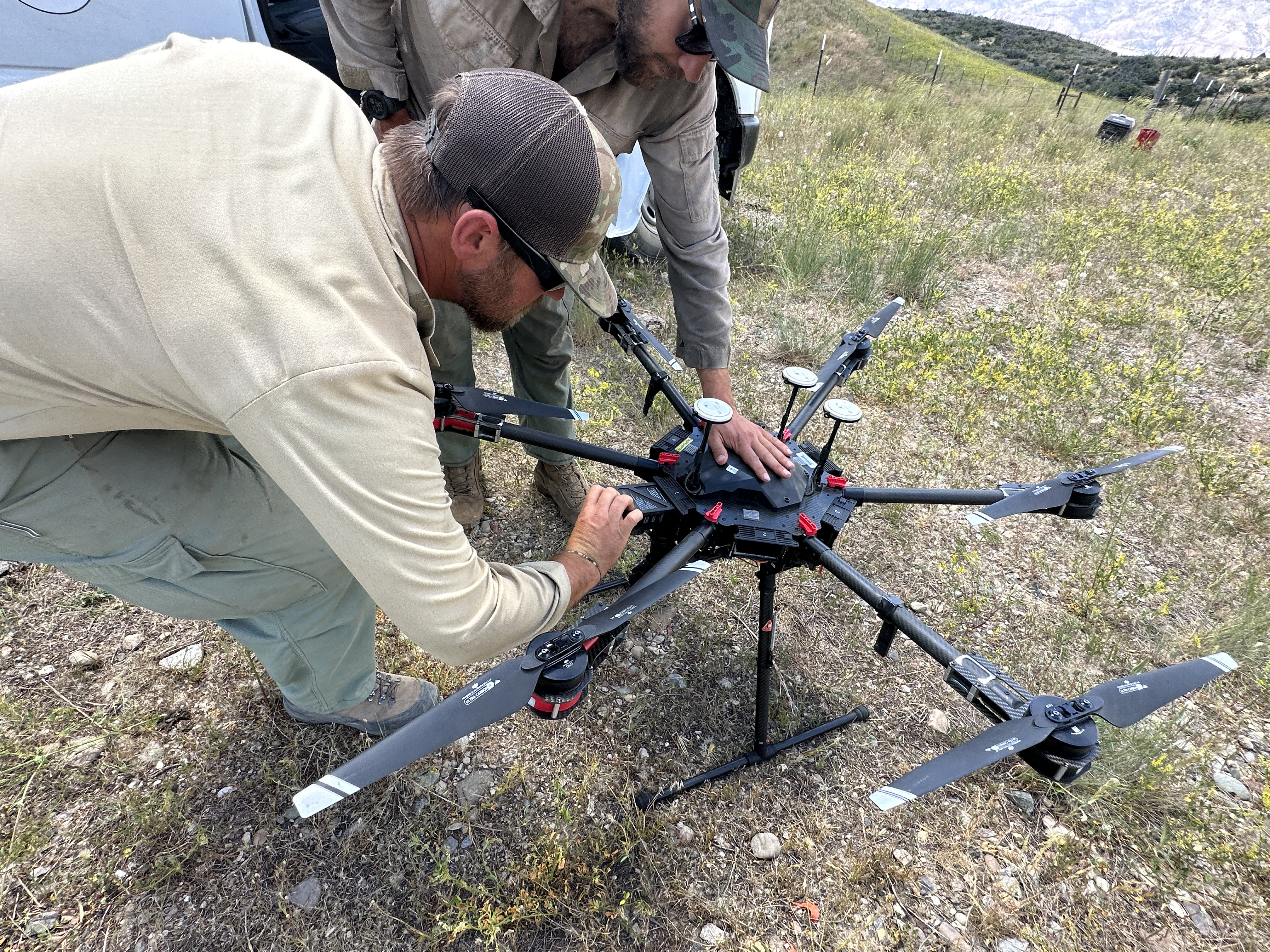
Uncrewed Aerial System to Assist on the Camp Creek Fire
Related Incident: Camp Creek Fire
Publication Type: News
Uncrewed Aerial Systems (UAS), or drones, are another tool which can be used during wildland fire operations.
A UAS module arrived on the Camp Creek Fire on September 2 to provide the incident management team with a better day-to-day large scale view of the fire through a live video camera feed. It can also assist with more accurate acreage reporting through infrared mapping. A specialized use of the device is to assist with firing operations, a process known as aerial ignitions because the application of fire comes from above rather than from firefighters on the ground.
If fire needs to be applied into areas firefighters cannot access on foot, they can carry small plastic spheres filled with potassium permanganate. The spheres are injected with glycol and dropped from the UAS. The combination of the glycol with the chemicals creates heat that ignites the spheres as they near the ground. Operators can release the spheres with a high degree of accuracy in terrain difficult to access on foot.
UAS operators identify units where fire will be introduced. They then create grids within each unit which the UAS will fly in a back-and-forth pattern. The grid is outlined with a geofence which reinforces that the UAS stays within the predefined boundary.
A helicopter can also be used for aerial ignitions and carry a larger load of the plastic spheres. Though a UAS needs to return more frequently to be resupplied with spheres, it has a safety advantage over a helicopter because, in the event of a mechanical failure, no personnel are at risk in an unmanned piece of equipment. A UAS also has the capacity to fly at night and conduct aerial ignitions when conditions may be more favorable.
There is a Temporary Flight Restriction (TFR) over the fire area, which includes public drone use. Illegal drone use in a TFR area can halt critical air resource support on the fire and compromise the safety of firefighters and other personnel working the fire.
Click each of the captions below to see images of the UAS and spheres.
- A metal box is attached to the bottom of a UAS. It contains both the spheres and a canister of glycol that will be injected into the spheres to initiate combustion
- Two UAS crew members attach a sphere container to the bottom of a drone in preparation for aerial ignitions
- Two UAS crew members replace the battery on the drone in order to continue firing operations
Note: The second and third photos above show two members of the Uniweep Fire Module from a fire earlier this season in Colorado. A similar crew and UAS arrived at the Camp Creek Fire on September 2.
Cowlitz Complex Update September 3 2023
Related Incident: Cowlitz Complex
Publication Type: News
Rocky Mountain Area Complex Incident Management Team Two
Jared Hohn, Incident Commander
Current Situation: A total of 504 personnel are currently assigned to the Cowlitz Complex, which remains at 5% containment. Minimal growth occurred over that last 24 hours. The Cowlitz Complex is 697 acres. Firefighter and public safety are the top priorities in any wildfire incident. Driving is one of the most hazardous activities for incident responders. It is often done at early and late hours when visibility is lowest, wildlife is most active, and crews are most tired. Heavy traffic on roads throughout the fire area is a hazard to the public as well as firefighters. Please travel slowly in congested areas in town and on the forest.
Most of the Gifford Pinchot National Forest has no recorded history of fire. The rarity of fire in this forest has resulted in a thick bed of decomposed, unburned fuel (duff) made up of leaves, needles, cones, sticks, branches, and logs at least five feet deep. In order to establish containment, firefighters first create a control line by scraping and digging through duff until they reach mineral soil. Next, they identify and extinguish peripheral heat sources that may be smoldering below the surface. It is exceedingly difficult to establish solid containment with five feet of duff that can carry fire across control lines. As a result, firefighters are cautious not to prematurely declare containment on fires within the Cowlitz Complex.
Under ideal weather conditions, yesterday aerial assets were able to fly resupply missions to fire crews working in remote locations. Additionally, reconnaissance missions allowed hotshot crew supervisors an ariel overview of the terrain providing much needed information for planning insertion and extraction tactics, while also prioritizing risk mitigation to firefighters and the public.
In Branch 1/Division C, the Cougar Gap, Allen Mountain, and Bertha May fires are out. Crews that have been working on the Carlton Ridge Fire are beginning to transition to the Deer Creek Fire. Crews are in place on the Skate, Silver, Yew, Pothole, and Berry fires, ensuring that hot spots with the potential to escape are extinguished.
In Branch 1/Division F, the Lake Creek Fire is out. The South Fork, Davis Creek, and Davis Mountain fires are in monitor and patrol status. Crews are actively suppressing the Willame Fire, while the Grassy Mountain Fire remains unstaffed as a strategy for safely getting crews into and out of the area is developed.
In Branch 1/Division L, the Blue Lake, Kickitat, St. Michael, and Horseshoe fires are out. The Twin Sisters Fire is in monitor and patrol status. Crews are taking suppression actions on the Adams Fork, Jackpot Creek, and Sanctuary Rock Fires. Aerial reconnaissance missions over the Mission Fire gave hotshot supervisors an opportunity to evaluate and recommend a plan of attack.
In Branch 2/ Division W, the McCoy Creek Fire is in patrol status, while crews are getting started on the Bear Creek Fire. Rappelers dropped in yesterday to the Quartz Junior fire, and responders are preparing to insert fire crews on the Snagtooth and Spencer Quartz fires in the coming days.
Fire Restrictions: Fire Restrictions are in effect. Campfires are prohibited across the Gifford Pinchot National Forest – only propane-fueled fire pits, stoves and lanterns are allowed. Additional information is available on the forest’s website at Gifford Pinchot National Forest - Fire Management (usda.gov).
Weather & Smoke Information: Scattered showers moved in this morning as a easterly marine layer is moving into the fire area. A cold front will move into the area around 5 pm bringing with it a chance of showers changing to overcast and drizzle by Monday. Winds will remain low in the valleys while higher elevations may see 15-20 mph gusts.
Closures: In anticipation of ongoing fire activity in the vicinity of the Snagtooth Fire the following roads and trails will be closed to the public to reduce exposure and help ensure public safety: Forest Roads 9300 and 9341 (currently off limits), Boundary Trail #1 (from Elk Pass to intersection with Summit Prairie), Summit Prairie #2, Craggy Peak #3, Snagtooth #4, Quartz #5, Stabler Camp #17, Wright Meadows #80, Basin Camp #3 A, Quartz #5 B, Quartz #5 C (French Creek), Snyder Pasture #80 A. Forest Road 8410 is closed for firefighter and public safety in the vicinity of the Pothole Fire. The road between the junction of Forest Roads 25 and 22 and 22 and 78 is temporarily closed for the next several days due to rollout is occurring.
Temporary Flight Restrictions: The temporary flight restriction (TFR) was modified yesterday, remaining north of Highway 12. Fire aviation response is halted or delayed if an unauthorized aircraft enters the TFR. Temporary flight restrictions also apply to unmanned aircraft systems or drones. If you fly, we can’t! Learn more about how to use drones safely and responsibly at Home-Know Before you Fly
South Fork Complex Update September 3 2023
Related Incident: South Fork Complex
Publication Type: News
South Fork Complex Update
Sunday, September 3, 2023
Fire Information: 530-638-2830, 8 a.m. to 8 p.m.
Email: 2023.southforkcomplex@firenet.gov
Linktree: linktr.ee/southforkcomplex2023
3-9 Fire: 2,868 acres with 35% containment
Pellitreau Fire: 3 acres with 100% containment
Pilot Fire: 1,055 acres with 100% containment
Sulphur Fire: 31 acres with 100% containment
3,957 total acres and 52% overall containment for the South Fork Complex
A total of 768 personnel, crews, air support, engines, dozers, and water tenders support the incident.
3-9 Fire With the wet weather Friday and Saturday, firefighters were able to evaluate opportunities to go direct on the fire due to the reduced fire activity. Dozers and hand crews were able to make good progress installing control lines along the northeastern perimeter in an area east of the Berry-Summit-Mad River Road (Route 1). Along this eastern flank, firefighters and heavy machinery worked to mitigate hazard trees so that firefighters can access the fire’s edge safely. Firefighters constructed hand line along the southern perimeter where difficult terrain prevents the use of heavy equipment while evaluating opportunities to go direct in the area east of Torrey Corrals. Crews worked diligently along the western flank strengthening existing control lines and mopping up smoldering material to secure the lines and increase containment. With warmer weather in the forecast, the lighter and smaller fuels will start to dry out and be susceptible to increased fire activity. As the ground dries out from the moisture received over the past few days, crews and equipment will work to make access deeper into the fire areas and continue building control lines to increase containment. Helicopters and air assets plan to assist ground crews with suppression efforts today as weather allows.
Pilot Fire is 100% contained. Crews have been monitoring the condition of the fire by walking the fire’s edge to ensure containment remains and there is no threat of rollout or escape.
The Pellitreau Fire and the Sulfur Fire are 100% contained. These fires remain in a patrol status with firefighters checking periodically that fire remains within the containment lines.
Weather: Morning fog then becoming partly cloudy with a 10% chance of scattered showers. A stray thunderstorm is possible in the afternoon. Maximum temperatures are expected to be 62-67 ºF, and minimum relative humidities are expected to be 50-55%. Northwest winds are predicted to be 6-10 mph with gusts up to 15 mph.
Evacuation Warning: In Humboldt County, an Evacuation Warning continues to be in place for Zone HUM-E114-A and Zone HUM E114-B. For more information go to the Humboldt County Sheriff’s Office website. In Trinity County, an Evacuation Warning continues to be in effect for Zone HYM-505 and Zone HYM-509. Please continue to check the Trinity County Wildfire and Evacuation website for up-to-date information.
Forest Closure: Forest Closure orders for the South Fork Complex Fire continue to be in effect and are posted on the Shasta-Trinity National Forest and the Six Rivers National Forest websites. Please avoid closed areas.
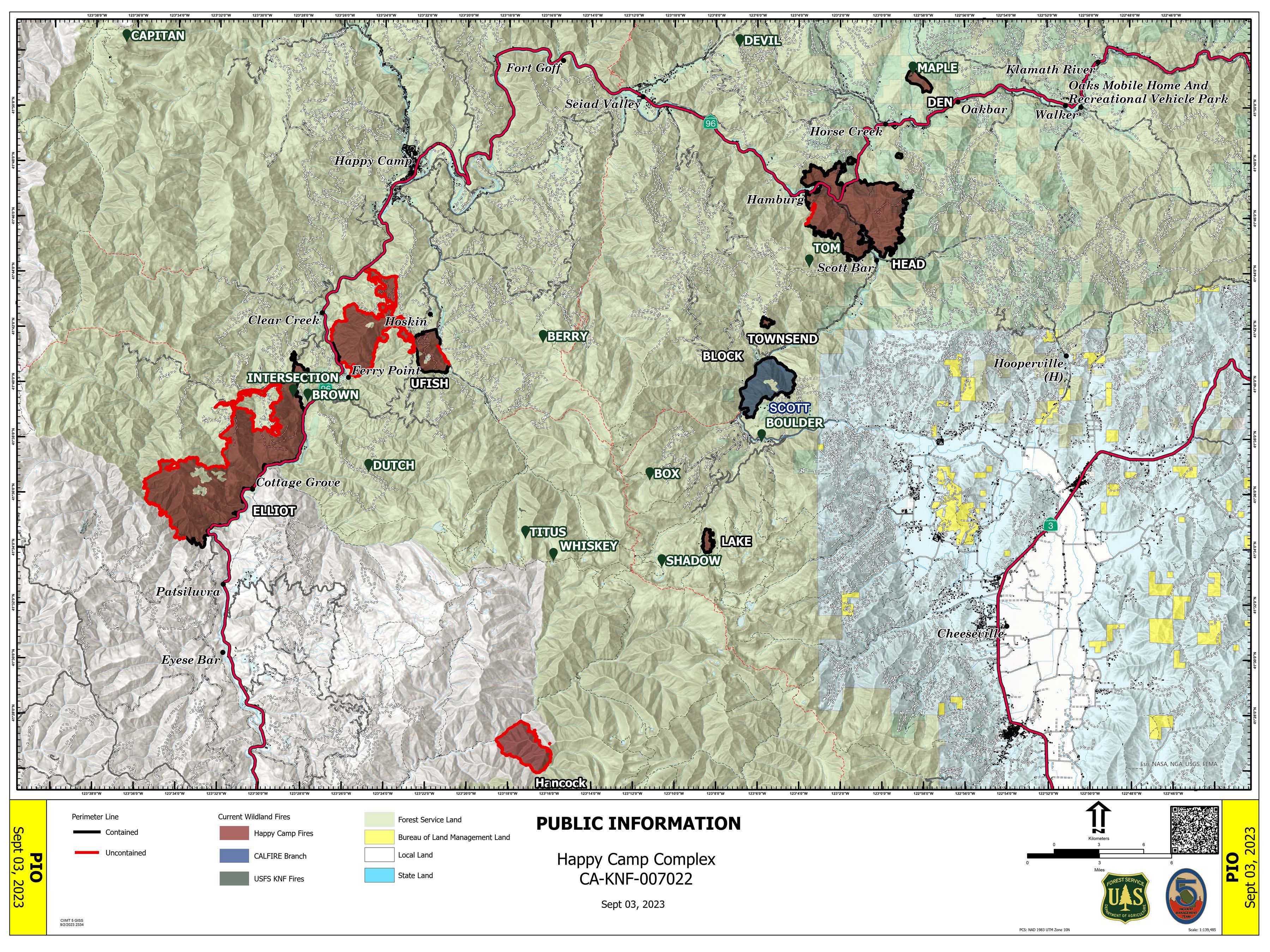
Happy Camp Complex Incident Update September 3 2023 Morning
Related Incident: 2023 Happy Camp Complex Klamath NF
Publication Type: News
HORSE CREEK COMMUNITY MEETING: A community meeting and fire operations update will be taking place today, September 3rd, at 5:30 p.m. at Klamath River Elementary School, located at 30438 Walker Road, Horse Creek, CA 96050.
WEATHER: Chances of rain and thunderstorms will decrease over the Happy Camp Complex today. Drier and warmer conditions are expected next week.
WEST SIDE OVERVIEW (ACRES/CONTAINMENT): Elliot (11,723 acres, 51%), Ufish (4,849 acres, 9%) Hancock (1,653 acres, 0%)
With recent rain over the Happy Camp Complex, firefighters saw minimal fire activity on the west side last night. Today, smokejumpers will be transported by helicopter to the Hancock Fire to evaluate the conditions and values at risk. The fire is burning in the Marble Mountain Wilderness and is most active on the east side. Today, firefighters on the Elliot Fire will continue to scout locations to build additional fire line on the west side of fire. Crews are mopping up along State Route 96. The Ufish continues to hold east of State Route 96 where firefighters are constructing fire line to prevent further spread.
EAST SIDE OVERVIEW (ACRES/CONTAINMENT): Head (6,940 acres, 91%), Block (0.1 acres, 100%), Townsend (81 acres, 100%), Den (294 acres, 100%), Scott (1,886 acres, 100%), Lake (199, acres, 100%)
Firefighters on the Head Fire continued to secure the last open section of fire line. Crews will begin removing equipment such as pumps and fire hose from the line. Suppression repair work will be ongoing. As of this morning, the Scott Fire is 100 percent contained.
EVACUATIONS: View current Siskiyou County evacuation orders and warnings by visiting: community.zonehaven.com. Siskiyou County residents are encouraged to sign up for rapid emergency notifications using the CodeRED emergency alert system at: www.co.siskiyou.ca.us/emergencyservices/page/codered-emergency-alert
ROAD CONDITIONS: No road work will be performed on State Route 96 through Wednesday, September 6th, at 7 a.m., to allow for holiday travel. Please keep in mind that one-way traffic control will remain in place from 2.8 miles west of Dillon Road to 8.8 miles east of Dillion Road, as this remains in an active fire area for the Elliot Fire. Motorists can expect up to 30-minute delays in this area. County road closures will be listed on the Siskiyou County Public Works website: www.co.siskiyou.ca.us/publicworks/page/closures-and-delays
FOREST CLOSURES: Two closure orders have been implemented: Happy Camp Complex Emergency Fire Closure No. 05-05-23-06 and No. 05-05-23-08. Additionally, fire restrictions remain in place to help minimize the chances of human-caused wildland fires. These restrictions prohibit campfires outside of designated improved recreation areas and wilderness. View closure orders, fire restrictions, and maps at: www.fs.usda.gov/alerts/klamath/alerts-notices
TEMPORARY FLIGHT RESTRICTION (TFR): A TFR has been established over the fire area. Flight restrictions include the use of drones. The operation of drones under the TFR is prohibited.
PACIFIC CREST TRAIL: The Pacific Crest Trail is now open between the Shelly Fork Junction and Seiad.
AIR QUALITY: For information regarding smoke impacts and what you can do to protect yourself, visit the Siskiyou County Air Pollution Control District Fire and Smoke Information website at: www.co.siskiyou.ca.us/airpollution/page/fire-and-smoke-information or AirNow.gov