
Tyee Ridge Complex Smoke Outlook 08302023
Related Incident: Tyee Ridge Complex
Publication Type: News
Informacin al da para el Incendio Smith River Complex South sbado3 de septiembre 2023
Related Incident: Smith River Complex
Publication Type: News
Fecha de inicio: 15 de agosto de 2023
Ubicación: Bosque Nacional Six Rivers
Causa: Relampagos
Acres: 84,802
Contención: 12%
Personal: 2,969
Reflejos: US-199 se abrió a todo el tráfico el sábado 2 de septiembre de 2023. Caltrans y CHP están dirigiendo el tráfico entre Patrick Creek y Oregon Mountain Road. El personal de bomberos, Caltrans y los equipos de construcción están trabajando activamente a lo largo de la carretera; Continúe teniendo precaución y conduciendo lentamente. Tenga en cuenta que las operaciones contra incendios están en curso, el Smith River Complex está activo y las condiciones podrían cambiar.
La Oficina del Sheriff del Condado de Del Norte, en colaboración con la Oficina de Servicios de Emergencia del Condado de Del Norte, redujo el nivel de evacuación en el Área de Oregon Mountain Road y la Zona de Evacuación Sun Star al Nivel 2. La repoblación de estas comunidades comenzó el 2 de septiembre.Un Mapa de evacuacion Interactiva está disponible para mantener a los residentes informados sobre los Niveles de evacuación actuales.
Operaciones: Se espera que el comportamiento del fuego aumente gradualmente en escala, duración e intensidad durante los próximos días. Se espera que el potencial de crecimiento más activo esté en el incendio Coon, ya que cierra la brecha con Forest Road 405 y a lo largo de Bear Basin Road para el incendio Kelly. Se espera que el incendio Hurdy Gurdy continúe avanzando hacia Bear Basin Road, continúe flanqueando hacia el oeste a lo largo de Fox Ridge Road y continúe retrocediendo lentamente cuesta abajo hacia el este hacia el río Smith.
Clima: El sábado por la noche cayeron precipitaciones mínimas sobre la zona del incendio. El domingo comenzará una tendencia al calentamiento y la sequía. La actividad de los incendios aumentará gradualmente, pero no se prevé un crecimiento significativo.
Humo: Espere humo donde el fuego se ha trasladado a las cicatrices de incendios forestales anteriores: Biscuit (2002), Bear and Coon (2015), Eclipse (2017) y Slater (2020). La información sobre la calidad del aire está disponible en https://www.airnow.gov/
Seguridad: La Oficina del Sheriff de Del Norte pide a los residentes que se abstengan de realizar viajes innecesarios. Las carreteras locales estarán muy activas con bomberos y aparatos contraincendios, especialmente entre las 6:30 y las 8:30 horas.
Restricciones/Cierres: Los cierres se ajustarán según la actividad del incendio. Todas las carreteras del condado dentro del área cerrada permanecen cerradas y están patrulladas por las autoridades.
Evacuaciones: Las órdenes de evacuación las emite la Oficina del Sheriff del condado de Del Norte. Si se encuentra en el área del condado de Del Norte, regístrese en su Sistema de alerta comunitaria para recibir notificaciones de emergencia. Las evacuaciones actuales están en línea : Mapa de evacuacion Interactiva
NIVEL 3 “Vaya ahora”: Rockland
NIVEL 2 “Prepárese”: Gasquet, Rowdy Creek/Low Divide, Big Flat/Rock Creek, Patrick Creek, Patrick Creek Lodge, Little Jones/Washington Flat Área residencial.
NIVEL 1 “Esté preparado”: Hiouchi
Información sobre incendios: 2023.smithrivercomplex@firenet.gov
Facebook: https://www.facebook.com/SixRiversNF
Tyee Ridge Complex Morning Update 090223 Spanish Version
Related Incident: Tyee Ridge Complex
Publication Type: Announcement
Tamaño: 6,674 acres
Contención: 15%
La contención aumenta en el Tyee Ridge Complex
Umpqua, Oregon. – La lucha contra incendios y el clima favorable resultaron en que los niveles de evacuación se redujeran en todo el complejo de incendios. No ha habido crecimiento en los perímetros de los incendios en las últimas 24 horas. Las carreteras permanecen cerradas en el área de Hubbard Creek, pero los residentes ya pueden regresar a sus hogares con prueba de residencia.
Las cuadrillas nocturnas continuaron preparándose para futuras operaciones de quema táctica y se pusieron en línea directa donde se puede acceder al fuego de manera segura. Los bomberos en el perímetro SE del incendio de Cougar Creek establecieron un cortafuego desde Bear Creek Road hasta Bear Creek y abrieron caminos para llegar al fuego de manera segura. En el extremo norte del incendio de Cougar Creek, los equipos continúan estableciendo líneas de contención hacia Cougar Creek. Todas las cuadrillas continúan extinguiendo y removiendo material combustible, abordando áreas ardiente y fuegos de combustible más grandes.
El Jefe de bomberos del Estado de Oregón y los equipos del Departamento de silvicultura de Oregón están utilizando cámaras infrarrojas de mano para localizar focos de calor alrededor de las estructuras y en el cortafuego. Estos dispositivos permiten a los bomberos identificar y abordar rápidamente los focos de calor durante las operaciones de extinción y protección de estructuras.
Hoy, el clima nuevamente ofrece condiciones favorables, con el potencial de más lluvia, hasta un cuarto de pulgada en áreas localizadas. Y como el comportamiento del fuego ahora es mayormente rastrero y ardiente, las cuadrillas aprovecharán las operaciones de día para establecer una línea directa donde sea posible y extinguiendo en todas las áreas. En la parte sur del incendio de Cougar Creek, los equipos están explorando ubicaciones para establecer líneas de contingencia. La protección de estructuras en Hubbard Creek Road consistirá en envolver estructuras, instalar mangueras, usar aparatos infrarrojas portátiles para identificar focos de calor y operaciones de extinción. El ataque aéreo permanece disponible para apoyar los esfuerzos de control.
Companion pets can be sheltered at Saving Grace Pet Adoption Center in Roseburg.
La Oficina del Sheriff del Condado de Douglas ha reducido los niveles de evacuación y eliminado el Nivel 3 que quedaba (¡Vayase ya!). Para ver el mapa de información de evacuación actual, vaya a www.dcso.com/evacuations. El refugio de la Cruz Roja cerrará hoy a las 12 PM. Para albergar ganado, comuníquese con el Control de animales del Condado de Douglas al 541-440-4471. Las mascotas de compañía pueden ser refugiadas en el Centro de adopción de mascotas Saving Grace en Roseburg.
Equipo 1 del Departamento forestal de Oregón
Joe Hessel, Comandante del incidente
Equipo rojo OSFM, Ian Yocum, Comandante del incidente
Ridge Doris Point and Tin Soldier Fires Daily Update Sept 3 2023
Related Incident:
Publication Type: News
Ridge Fire
Location: 6 miles southeast of Hungry Horse
Size: 3,665 acres
Percent Contained: 76%
Cause: Lightning
Start Date: July 30th, 2023 @ 3:45 PM
Personnel Assigned: 224
Doris Point Fire
Location: 8 miles south of Hungry Horse
Size: 1,610 acres
Percent Completed: 98%
Cause: Lightning
Start Date: July 30th, 2023 @ 3:45 PM
Personnel Assigned: 16
Tin Soldier Fires
Location: 17 miles east of Swan Lake
Size: 8,165 acres
Percent Completed: 95%
Cause: Lightning
Start Date: July 30th, 2023 @ 3:45 PM
Personnel Assigned: 50
Highlights:
Unless significant activity occurs, this will be the final update for the Ridge, Doris Point, and Tin Soldier Fires. Southwest Incident Management Team 1 will transfer command of the fires back to a local Type 3 organization on Tuesday, September 5th at 0700. With the recent heavy rainfall that covered much of the fire areas and the forecasted rain in the coming days, little to no fire activity is expected again on the Ridge, Doris Point, or Tin Soldier Fires (Bruce and Sullivan fires).
Yesterday, local forest engines were suppressing the new lighting started Soldier Fire, located near Soldier Creek, when they discovered a second lightning struck tree. A helicopter assisted local firefighters with water bucket drops and Tin Soldier Complex fire managers continued to support with resources as needed. Fire officials were able to call the new starts contained at 6:30 p.m. on 9/2.
Operations:
Ridge and Doris Point Fires:
Heavy equipment will continue working to repair roads near the Ridge Fire that were impacted by fire suppression activities. One smoke was observed and extinguished by firefighters on the Doris Point fire on 9/2.
Tin Soldier Fire:
Road grading work is nearing completed along FS RD 895, near the bridge over the South Fork Flathead River. Crews and an excavator are finishing the repair of the fire and hand line along Meadow Creek. Firefighters will clean up the remaining tree debris from the mechanical thinning and log skidding project along roadways in the Meadow Creek area.
Weather and Fire Behavior:
Increasing clouds and southwesterly winds are expected today with cooler temperatures and isolated rain showers. A cold front will push through the area tonight likely bringing more rain followed by rain showers though out the day tomorrow with even cooler temperatures.
The Hungry Horse Reservoir closure order has been modified to allow access to the east road of the reservoir and on the west road down to the Doris Point Boat Launch. The lake is now open for recreation. The closure remains in place on the west side of the reservoir for firefighter and public safety. For the most up to date closure information visit, https://www.fs.usda.gov/alerts/flathead/alerts-notices/?aid=82283
The Heinrude Community evacuation was lifted for residents but due to the forest closure residents need to contact the Hungry Horse Ranger Station at (406) 387-3800 to arrange access to their properties. For the most current information regarding evacuation status please visit https://flathead.mt.gov/department-directory/oes/emergency-management/ridge-fire-information.
Additional Information:
Information for the Ridge, Doris Point, and Tin Soldier Complex Fires is found at https://inciweb.nwcg.gov/incident-information/mtfnf-ridge-fire. For wildfire preparedness tips visit, https://www.ready.gov/wildfires.
Oregon Fire Update 3 September 2023
Related Incident: Oregon Fire
Publication Type: Announcement
Fire Size: 10,817 acres
Initial Start: 8/18/2023 at 1600 pm
Location: Approximately 4 miles northeast of Elk, WA.
Cause: Under Investigation
Containment: 88%
Resources Committed: 26 Engines, 6 Crews, 1 Bulldozer, 7 Water Tenders, 2 Skidgen
Personnel: 263
Damage Assessment: 126 primary homes and 258 outbuildings destroyed.
Road Closures: None
Elk, WA, - Current Situation: Northeast WA Incident Management Team 3 took command of the Gray Fire last night at 6 p.m. from Northwest Incident Management Team 7 through a seamless transition. Northeast WA Incident Management Team 3 will manage both the Oregon and Gray Fire until work is complete.
The Oregon Fire continues to remain within the current footprint with no further growth. The current strategy remains full suppression. Firefighters continue to work diligently to meet the objective of the current strategy and are expected to continue their efforts over the next two weeks.
Today’s activities: Firefighters continue to build upon their success from yesterday to seek out remaining hot spots and mop-up the fires perimeter as well as the interior around structures. Mop-up and suppression repair will continue across all divisions of the fire.
Disaster assistance: With the Disaster Assistance Center closed, people affected by the wildfires can contact the represented organizations directly. Please visit Spokane County Emergency Management website for the contact information for the agencies and organizations.
Evacuations: All evacuations throughout the entire fire area have been rescinded.
Weather: Moisture content will remain elevated over the area into Monday. A weak weather system passing through on Sunday will bring a 20% chance of showers and thunderstorms mainly during the afternoon and evening hours.
For fire information contact the Public Information Officer at 509-508-3323 or email 2023.oregon@firenet.gov
Deep Fire Update September 3 2023
Related Incident: Deep Fire
Publication Type: Announcement
CURRENT SITUATION
The Deep Fire is expected to have moderate burning conditions today and is currently mapped at 4,192 acres with 60% containment.
Crews are re-engaging in fire suppression efforts on the fire line after being pulled for firefighter safety during the heavy rain event. They will seek opportunities to fight the fire directly in the northern flanks of the fire’s edge south of Little Salt Creek. From a recon flight yesterday, the fire appears to remain smoldering with visible smoke after recent rain showers in the north. An infrared flight has been requested for today to obtain heat signatures in the fire footprint as visibility clears and conditions allow. On the line, crews will continue mop up along containment lines on the west, south, and east side of the fire. They will pull excess hose lay along the Stuart Fork Trail in the southern end of the fire to reallocate in the northern section of trail towards Morris Meadows. As crews secure containment lines, they will monitor for, and extinguish hot spots in areas with burnt snags or logs that retain heat. This effort will be conducted near Sunday Creek on the southeast side where safe to do so with air support for suppression as needed. Hazard trees, debris flow, log roll out, and slick driving and hiking conditions remain the main safety concern.
Repair work along contingency lines and roads are paused for today from heavy rains to reduce compacting high clay soils. Crews are evaluating opportunities to continue suppression repair as soils dry. As crew re-engage suppression efforts and repair, they look to ensure wilderness character is protected during and after fire operations by following Leave No Trace principles and using minimal impact suppression techniques.
WEATHER
The relative humidity is lower today than previous but will increase tonight. The day will be mostly cloudy with isolated showers in the fire area. Winds today are expected to come from the southwest shifting west in the afternoon.
FOREST CLOSURES
There is a forest closure associated with the Deep Fire. For current information on forest closures, visit https://www.fs.usda.gov/stnf
EVACUATION UPDATES
For the latest evacuation information from the Trinity County Sheriff’s Department: https://www.facebook.com/people/Trinity-County-Sheriffs-Office/100064589806351/
For information on evacuation resources from the Trinity County Office of Emergency Services: https://www.trinitycounty.org/OES
To sign up for codeRED notifications: text “TrinityCA” to 99411.
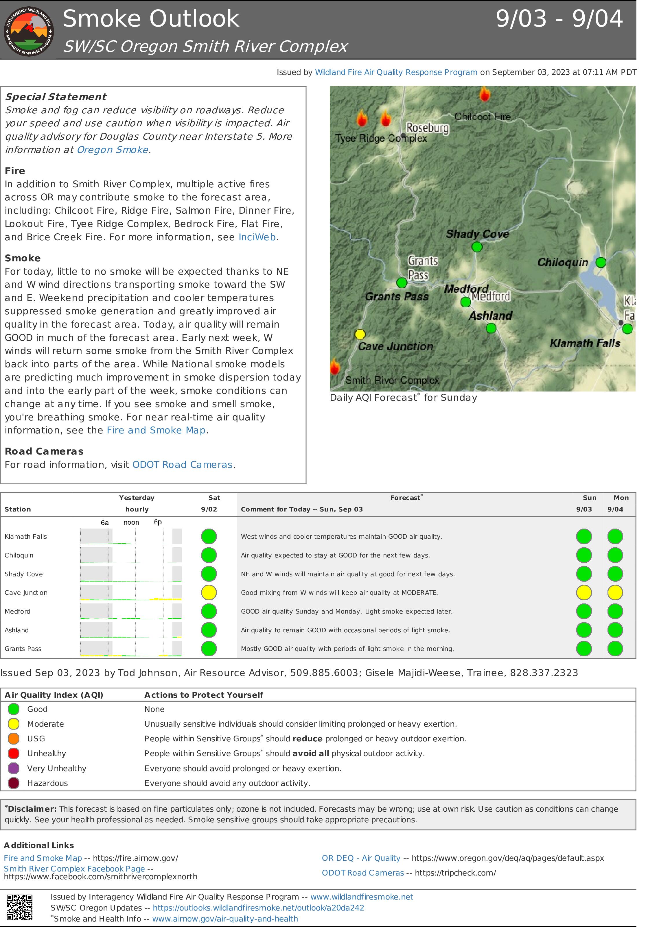
Smoke Outlook 93 94 Smith River Complex
Related Incident: Smith River Complex
Publication Type: News
Special Statement
Smoke and fog can reduce visibility on roadways. Reduce your speed and use caution when visibility is impacted. Air quality advisory for Douglas County near Interstate 5. More information at Oregon Smoke.
Fire
In addition to Smith River Complex, multiple active fires across Oregon may contribute smoke to the forecast area, including: Chilcoot Fire, Ridge Fire, Salmon Fire, Dinner Fire, Lookout Fire, Tyee Ridge Complex, Bedrock Fire, Flat Fire, and Brice Creek Fire. For more information, see InciWeb.
Smoke
For today, little to no smoke will be expected thanks to NE and W wind directions transporting smoke toward the southwest and east. Weekend precipitation and cooler temperatures suppressed smoke generation and greatly improved air quality in the forecast area. Today, air quality will remain GOOD in much of the forecast area. Early next week, west winds will return some smoke from the Smith River Complex back into parts of the area. While National smoke models are predicting much improvement in smoke dispersion today and into the early part of the week, smoke conditions can change at any time. If you see smoke and smell smoke, you're breathing smoke. For near real-time air quality
information, see the Fire and Smoke Map.
Road Cameras
For road information, visit ODOT Road Cameras.
Tyee Ridge Complex Morning Update 090323
Related Incident: Tyee Ridge Complex
Publication Type: Announcement
Acreage: 6,674
Containment: 21%
Crews Prepare Firing Operations on the Tyee Ridge Complex
UMPQUA, Ore. – Night Shift fire crews took advantage of the good humidity recoveries to make solid progress on the fireline. Crews mopped up containment lines, and connected and constructed control and contingency lines for upcoming tactical firing operations.
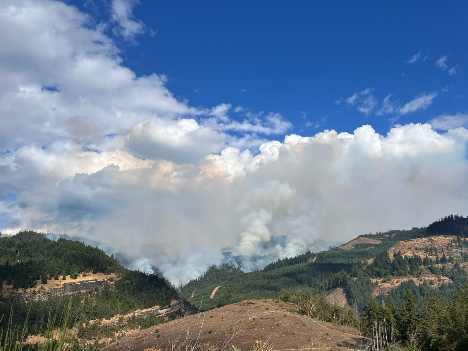
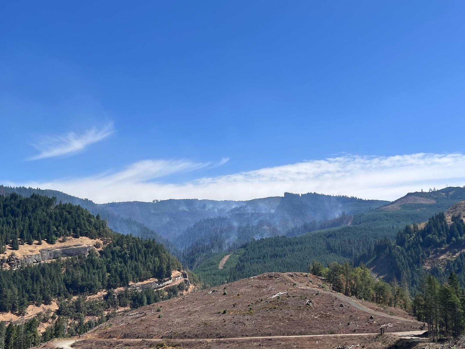
Today, Oregon Department of Forestry crews will continue line construction for tactical firing operations. Since certain areas are too steep and dangerous for firefighters to put a handline in, indirect line is constructed in a safer location. The area between that line and the fire is burned off. This strategy is a very effective way to “fight fire with fire” and plan to hault fire spread. The tactical firing will happen in a small area that crews can’t access on the east portion of the fire. Additional fire crews were moved in to assist with the tactical firing. The tactical burn will work itself NE along the uncontained edges of the fire. This activity will increase smoke over the fire today. Air resources will be flying today, continuing to monitor any spotfires that may occur, dropping water, and supporting firefighters on the line by dropping retardant.
Today’s weather will bring light fog in the morning that will clear in the afternoon. No thunderstorms nor rain are expected today but skies will be partly cloudy. Fuel moistures are expected to decrease. This will cause the current creeping and smoldering fire to become more active in the afternoon.
With the favorable weather earlier this week minimizing threats to structures , the Oregon State Fire Marshal resources, including the Red Incident Management, Team are returning to their home agencies today. The delegation will be turned back over to local authorities for fire response. If the need arises for structural protection, resources could be asked back. OSFM thanks the community for their support.
To view the current evacuation information map, go to www.dcso.com/evacuations. To shelter livestock, contact Douglas County Animal Control at 541-440-4471. Companion pets can be sheltered at Saving Grace Pet Adoption Center in Roseburg.
Oregon Department of Forestry Team 1
Joe Hessel, Incident Commander
OSFM Red Team, Ian Yocum, Incident Commander
Tyee Ridge Complex Evening Update 090223 Spanish Version
Related Incident: Tyee Ridge Complex
Publication Type: Announcement
Tamaño: 6,674 acres
Contención: 21%
Aumenta la contención en Tyee Ridge Complex
Umpqua, Ore.: Los incendios de Tyee Ridge Complex mostraron crecimiento mínimo el día de hoy. Esta noche, los bomberos se preparan para condiciones climáticas cambiantes y tormentas. Las actividades se concentran en neutralizar las líneas de contención y en prepararlas para las próximas operaciones. Los niveles de evacuación no han cambiado, las vías permanecen cerradas en el área de Hubbard Creek, y los residentes pueden volver a sus hogares con una prueba de residencia.
Hoy, los equipos del Departamento forestal de Oregón siguieron combatiendo el fuego de forma más directa gracias a las condiciones climáticas favorables. A lo largo de las líneas de contención del incendio de Cougar Creek, los bomberos están construyendo una línea de mano con maquinaria para conectar y contener las líneas de contención para las futuras operaciones contra el incendio. Las fuerzas de operaciones del Alguacil de incendios del estado de Oregón siguen patrullando y limpiando alrededor de las estructuras. Hoy fueron desmovilizadas dos unidades de operaciones debido a la disminución del riesgo a las estructuras. Sin embargo, en caso de cualquier cambio, los recursos del OSFM estarán disponibles de inmediato.
Los helicópteros permanecerán activos vertiendo agua sobre las partes activas del incendio. Esta tarde, un avión detectó un incendio en la parte NO del incendio de Cougar Creek que fue contenido rápidamente. El incendio de Tyee Ridge Complex permanece activo y permanece la posible existencia de focos. Los equipos actuaron con rapidez para identificar y extinguir los nuevos focos de incendio.
En la tarde, una tormenta trajo vientos fuertes y una breve lluvia fuerte sobre el lado SO del incendio de Cougar Creek. Se pronostican más tormentas para esta noche que pudieran traer consigo rayos y lluvia pesada. Hay camiones adicionales disponibles para combatir un nuevo incendio provocado por rayos.
Para ver el nuevo mapa de evacuación vigente, visite www.dcso.com/evacuations. El refugio de la Cruz Roja cerró hoy a las 12 PM. Para refugiar ganado, comuníquese con el Departamento de control animal del condado de Douglas al teléfono 541-440-4471. Las mascotas pueden refugiarse en el Centro de adopción animal Saving Grace, en Roseburg.
Equipo 1 del Departamento forestal de Oregón
Joe Hessel, Comandante del incidente
Equipo Rojo OSFM, Ian Yocum, Comandante del incidente
2023 SRF Lightning Complex and Redwood Lightning Complex Update Sunday 90323
Related Incident: 2023 SRF Lightning Complex and Redwood Lightning Complex
Publication Type: News
Fire Update
2023 Six Rivers National Forest Lightning Complex & Redwood Lightning Complex
Sunday, September 3, 2023 – 9:00 a.m.
Rocky Mountain Complex Incident Management Team 1
Dan Dallas, Incident Commander
Information Phone: 530-536-0767
Email: 2023.lightningcomplex@firenet.gov
Information Staffing Hours: 8 am to 8 pm
Current Situation: The 19 fires on this incident total 16,478 acres and overall containment is 20%. One new fire started due to lightning in the Bridge Ridge area and firefighters are extinguishing the single tree fire this morning.
Redwood National and State Parks Area Fires
Lost Fire - Crews continue to work on full suppression, prepping control lines on the north flank. At the same time, unnecessary equipment is being backhauled for use elsewhere.
Bridge Ridge, Devil and Glen - Fires are contained and in patrol status and crews continue to check the fires daily.
Hoopa Area Fires
Lone Pine Fire - Fire is contained and continues in patrol status, being checked by crews as needed.
Orleans and Somes Bar Area Fires
Pearch Fire - Hose line has been completed between the fire’s edge and Orleans around values at risk. Additional assessments continue, with support from incident resource advisors, assessing potential lines south and east of Orleans. Crews mopped up and secured line overnight. Structure protection assessments in the area continue.
Bluff 1, Mosquito, Bigfoot, Blue Creek 2, Marlow, Copper - Firefighters continue to prepare indirect lines around the fires utilizing dozer lines, handlines, masticators, and chipping operations.
Creek, Flat, Iron- These fires are contained and in patrol status, both by ground and by air.
Monument, Merrill, Let er-Buck - Due to difficult terrain and safety concerns, these fires are unstaffed but being checked daily.
Evacuations: There are evacuation warnings in the areas listed below, but no actual evacuations currently. Anyone in an evacuation warning area should be prepared for potential evacuations, including packing personal supplies, and arranging overnight accommodations. Be ready to go at a moment's notice.
Pearch Fire Evacuation Warnings: Zone HUM-E009 (Southeast of the Klamath River in Orleans); Zone HUM-E008-B (Community of Orleans, west of Klamath River. East of Crawford Creek, including Orleans proper). Hwy 96 and Red Cap Road along the east bank of Klamath River, south from Salmon River, east to Orleans Mountain. Approximately 243 residents live in these two zones.
Siskiyou County Evacuation Warnings: Zone SIS-1701: NORTH of Monte Creek Road, SOUTH of Camp Three Road, EAST of Camp Three Road, WEST of Wooley Creek Trailhead. Also zones SIS-1402, SIS-1515, and SIS-1518.
Weather: In the last 48 hours, the fire areas have seen approximately 0.5 to 0.75 inches of rain. Temperatures will remain below normal in the 60s and 70s, but slowly warm back into the upper 70s to lower 80s with humidity lowering to 40-50%. Light northwest winds are forecast during the afternoon.
Closures
Six Rivers National Forest: Area and campground closures are in effect on portions of Six Rivers National Forest. They can be found at: https://www.fs.usda.gov/detail/srnf/notices/?cid=FSEPRD1096395 .
Redwood National Park and State Park: There are multiple closures in the parks due to several fires, including closures in the Lost Man area. For a full list of closures and impacts, please visit: www.nps.gov/redw/planyourvisit/conditions.htm .
Alert Notifications
ZoneHaven/Genasys for map and zone identification: https://protect.genasys.com .
Humboldt County Residents Register for Humboldt Alert Notification: www.humboldt.gov/alerts
Siskiyou County Resident Register at Code Red Alert Notification: https://public.coderedweb.com/CNE/en-US/6F327CCDFFFD .
Fire Information Contacts
2023 SRF Lightning Complex Information:
Phone: 530-536-0767 | Email: 2023.lightningcomplex@firenet.gov
InciWeb: https://inciweb.nwcg.gov/incident-information/casrf-2023-srf-lightning-complex
Facebook: https://www.facebook.com/2023SRFRedwoodLightning
Redwood National and State Parks Information Hotline: Phone: 707-464-6101
https://www.nps.gov/redw/planyourvisit/conditions.htm
Hoopa Information Hotline: Phone: 530-618-2995 | Email: serene.oes@gmail.com
More Fire Information Links: www.linktr.ee/srffirepio