
2023 SRF Lightning Complex and Redwood Lightning Complex Update 90423
Related Incident: 2023 SRF Lightning Complex and Redwood Lightning Complex
Publication Type: News
Fire Update
2023 SRF Lightning Complex & Redwood Lightning Complex
Monday, September 4, 2023 – 9:00 a.m.
Rocky Mountain Complex Incident Management Team 1
Dan Dallas, Incident Commander
Information Phone: 530-536-0767
Email: 2023.lightningcomplex@firenet.gov
Information Staffing Hours: 8 am to 8 pm
Special Note: This update covers 9 of the 19 fires currently being managed as part of the Complexes plus one new initial attack fire. The remaining 10 fires are listed in the accompanying Complex Overview. Those fires, totaling 1,746 acres, are contained and in patrol status. They are checked daily, and their size and containment status are unlikely to change.
Current Situation: The 19 fires in this incident total 16,478 acres and overall containment is 20%. The nine uncontained fires described below total 14,731 acres. Hog Fire and Lost Fire are in Redwood National and State Parks. All other fires described in this update are in Six Rivers National Forest.
Hog Fire (0.2 acres) – This is a new fire detected on Saturday in the southern end of the National Park. It was an initial attack assisted by the Rocky Mountain team and is not an official part of the Complex. The fire is a lightning strike in a single cedar tree. The burning tree has been felled and the fire is lined and in mop up status.
Lost Fire (722 acres, 55% contained) – Indirect line construction has been completed on the north side of the fire in Division AA. A short portion of the fire perimeter in the northwest corner is too steep and rocky to safely put firefighters in. The current focus of activity on this fire is backhaul of unneeded equipment for use in other areas.
Pearch Fire (4486 acres, 5% contained) – Crews are continuing to mop up and secure firelines in the southeast portion of the fire in Division Z and to improve lines in the southwest corner in Division J. No additional firing operations are planned on the fire at this time. The structure protection group is conducting structure assessments along the Salmon River corridor to the east of the fire in Division Y. These will be compiled into a product that will be useful to local agencies in the event of any future emergencies. Hoses, sprinklers, and other structure equipment have been deployed in some locations as a preventative measure,
Bluff #1 (1993 acres, 0% contained) and Mosquito (2447 acres, 5% contained) Fires – Mastication on an indirect fireline north of Mosquito Fire is done and chipping occurred yesterday. A dozer line along a portion of Bean Ridge has been cleaned up, and hand crews will extend the line further northeast to Highway 96. The east side of Mosquito Fire is contained by direct line along the Cedar Camp Road in Division M. An indirect line has been completed westward from the southeast corner of Mosquito Fire in Division M. Mastication has been completed along an indirect line that runs from north of Bluff #1 Fire, along the west side of that fire, and southward in Division N. The plan is to connect the south end of this line to the line running west of Mosquito Fire with handline starting today. Four chippers will be working to remove slash from the masticated indirect lines, with an expected four days of operations needed.
Blue Creek #2 (2898 acres, 0% contained), Marlow (1491 acres, 0% contained), and Copper (619 acres, 0% contained) Fires – These fires are being patrolled by aerial resources as weather conditions allow. They are bounded by indirect control lines to the east and south, and significant movement of these fires is not expected.
Monument (2 acres, 0% contained) and Let er-Buck (73 acres, 0% contained) Fires – Due to limited values at risk, the remote, steep terrain and associated safety concerns for our firefighters, and the low probability of success using standard suppression tactics, these fires are being addressed with a confinement strategy. Terrain, natural fire barriers such as rock outcroppings, and old fire footprints where fuels are limited will be used to confine fire growth until season ending precipitation extinguishes the fires. These fires are checked regularly by aerial patrols to ensure they remain within acceptable bounds, and little to no fire growth has been observed.
Weather: Following 0.5 to 0.75 inches of rain across the Complexes over the past few days, today will bring a 10% chance of precipitation with decreasing clouds. A warming, drying trend begins today and will intensify over the next several days. Temperatures will be seasonal in the 60s and 70s. Winds will be light from the west.
For information on Closures, Evacuations, and Alert Notifications please see the accompanying Complex Overview.
Fire Information Contacts
Phone: 530-536-0767 | Email: 2023.lightningcomplex@firenet.gov
InciWeb: https://inciweb.nwcg.gov/incident-information/casrf-2023-srf-lightning-complex
Facebook: https://www.facebook.com/2023SRFRedwoodLightning
Redwood National and State Parks Information Hotline: Phone: 707-464-6101
https://www.nps.gov/redw/planyourvisit/conditions.htm
Hoopa Information Hotline: Phone: 530-618-2995 | Email: serene.oes@gmail.com
More Fire Information Links: www.linktr.ee/srffirepio
Community Meeting to be held on Wednesday September 6
Related Incident: Camp Creek Fire
Publication Type: Announcement
A community meeting is scheduled for 6:30 p.m. Wednesday evening, September 6th, to answer questions and listen to concerns about the Camp Creek Fire.
The community meeting will be held at the Mt. Hood Lions Club at 24730 E. Woodsey Way in Welches.
We will attempt to livestream the meeting on Facebook at the following link: https://www.facebook.com/campcreekfire
Tyee Ridge Complex Morning Update 090423
Related Incident: Tyee Ridge Complex
Publication Type: Announcement
Acreage: 7.257
Containment: 28%
Firefighters Securing Lines and Mop Up on Tyee Ridge Complex
UMPQUA, Ore. – Last night, firefighters continued to secure the fireline and mop up around homes. The infrared drone flew to detect potential hotspots on the fire. More favorable weather last night brought light rain to the area allowing crews to continue their hard work setting up the day shift for success.
Today, the weather will provide more light showers through the early morning with clearing in the afternoon. Fair-weather skies and sun will contribute to fuels drying out later in the day. Currently, the fire behavior is creeping and smoldering, and with shifting weather during the middle of the day may cause some flare ups.
Oregon Department of Forestry crews will continue to secure the fireline by improving lines and mitigate tree hazards for firefighter saftey. Helicopters will be working today, dropping water on the more active parts of the fire, clearer skies will assist them in these efforts. Structure protection is in place if there is a need as firefighters mop up around homes. Initial attack resources will be available for any new starts occuring in the area.
Tactical firing operations may take place today and plans are subject to change if favorable weather conditions do not occur. Tonight’s weather will bring cooler air and a return of increased humidity.
Poison oak is a hazard in the field. Safety awareness information about this plant is offered in both Spanish and English for all crews. Tecnu and Zanfel, which are different types of washes, are being provided as treatment.
To view the current evacuation information map, go to www.dcso.com/evacuations. To shelter livestock, contact Douglas County Animal Control at 541-440-4471. Companion pets can be sheltered at Saving Grace Pet Adoption Center in Roseburg.
Oregon Department of Forestry
Joe Hessel, Incident Commander
Lookout Bedrock Horse Creek Pothole Fires Daily Update 942023
Related Incident: Lookout FireBedrock Fire2023 Horse Creek Fire
Publication Type: News
Lookout/Horse Creek/Pothole Fires/Bedrock
September 4, 2023
Morning Update
ALERT: There may be short closures on Highway 126 as firefighters are removing fire damaged hazard trees.
Lookout: Total Personnel: 701
Size: 24,581 acres l Start Date: August 5, 2023 l Cause: Lightning l Containment: 20%
Resources: 32 engines l 14 crews l 7 bulldozers l 29 water tenders l 8 masticators l 6 helicopters l 1 Skidder
The eastern side of the fire received light rain Sunday morning, resulting in minimal fire activity. Today, steep terrain on the western flank will be worked by Hot Shot crews to secure the fires edge. Crews will continue to prepare contingency lines, and work on hot spots throughout the fire area. Smoke will continue to impact the McKenzie drainage along Highway 126.
Horse Creek: Total Personnel: 192
Size: 765 acres l Start Date: August 24, 2023 l Cause: Lightning l Containment: 12%
Resources: 18 engines l 4 crews l 4 bulldozers l 9 water tenders l 2 masticators l 2 Skidders l 2 Excavators
Yesterday firefighters patrolled the fires edge and continued strengthening and improving completed fire lines. Significant heat from burning, dead and down heavy fuels remain on the eastern side of the fire in steep rugged terrain. Crews will continue extinguishing and removing burning material along completed fire lines, and patrolling along roads.
Pothole: Total Personnel: 90
Size: 109 acres l Start Date: August 25, 2023 l Cause: Lightning l Containment: 15%
Resources: 7 engines l 1 crews l 1 bulldozers l 4 water tenders l 1 Masticator l 3 Skidders
There was little fire activity yesterday allowing firefighters to make good progress on containment. Today Firefighters will maintain established fire lines and continue to secure the perimeter.
Bedrock: Total Personnel: 419
Size: 31,590 acres l Start Date: July 22, 2023 l Cause: under investigation l Containment: 85%
Resources: 18 engines l 12 crews l 5 bulldozers l 18 water tenders l 7 masticators l 6 helicopters l 4 Skidder
On the north side of the fire, crews have been chipping brush, removing and processing logs to help reduce fuel loads. The suppression group will continue to work on uncontained lines, provide initial attack capabilities, and continue to assist the Willamette National Forest with nearby fires. Excess fire equipment continues to be removed and returned to base camp for servicing and cleaning.
All Fires
Recent rains, higher humidity, and cooler temperatures have combined to moderate the burning intensity and slowed the fires growth. However, this has resulted in smoldering and creeping fire that is conducive to increased smoke development. Valleys, drainages, and transportation corridors may be subjected to periods of dense smoke. Smoldering fire will continue to weaken standing trees, creating an extreme hazard to firefighters and equipment.
Weather
The weather pattern that has been in place will continue for at least one more day. The rain has allowed firefighters to make good progress on all fires. Fire activity is expected to be minimal today as the weather remains cool and relatively humid.
Evacuation Centers: An evacuation center is in place at Westridge Middle School in Oakridge for evacuees and small pets from the Horse Creek and Lookout Fires. For assistance with large animal evacuations, please call 541-285-8227.
Evacuation Update: There is potential for reducing evacuation levels in several zones over the next few days.
Additional information can be found at the following websites.
Lane County Evacuations: https://www.lanecountyor.gov/cms/one.aspx?pageId=19729054
Linn County Evacuations: https://www.linnsheriff.org/
Road Closures:
Highway 242, McKenzie Highway, is closed between milepost 61-76, 14 miles west of Sisters, Oregon to just east of the junction with Highway 126. Highway 126 is currently open. Please monitor Trip Check for any updates at: https://tripcheck.com/
Forest Closures: Willamette National Forest reduced the closure area for the Bedrock fire due to successful firefighting efforts. Many popular sites and trails have re-opened including the Alpine Trail. There are no changes to closure areas for the Lookout, Horse Creek, and Pothole fire areas at this time. These closures help provide firefighters with safer driving conditions and decrease the potential for search and rescue operations that could interrupt firefighting activities. Closures can be found at: https://www.fs.usda.gov/detail/willamette/alerts-notices/?cid=fseprd552029
Restrictions: Fire Restrictions are in place on the Willamette National Forest: https://www.fs.usda.gov/willamette. Temporary Flight Restrictions remain in place over the Bedrock and Lookout fire areas.
Smoke Outlook: https://outlooks.wildlandfiresmoke.net/outlook/4c92bc1a The Fire and Smoke Map (fire.airnow.gov) is another source for air quality information.
Lookout Information Line: 541-215-6735 (8 a.m. - 8 p.m.)
Email: 2023.lookout@firenet.gov
Facebook: https://www.facebook.com/LookoutFire2023
Inciweb: https://inciweb.nwcg.gov/incident-information/orwif-lookout-fire
Bedrock Fire Information: 541-414-6272 (8 a.m. - 8 p.m.)
Email: 2023.bedrock@firenet.gov
Facebook: https://www.facebook.com/BedrockFire2023/
InciWeb Bedrock: https://inciweb.wildfire.gov/incident-information/orwif-bedrock-fire
Smith Complex Fire South Zone Daily Update September 4 2023
Related Incident: Smith River Complex
Publication Type: News
Start Date: Aug 15, 2023
Location: Six Rivers National Forest
Cause: Lightning
Acres: 85,429
Containment: 19 percent
Personnel: 2,642
Current Situation: Sunday was an opportune day for crews working in all areas around the South Zone. They took advantage of recent widespread moisture to create and improve dozer lines, hold and monitor past firing operations, and plan and prepare for potential firing operations later this week. On the northwest side of the fire, Southwest Area Team 2 Operations Supervisors are working closely with their North Zone counterparts on Pacific Northwest Team 13 to develop a unified fire-suppression strategy. Crews in Gasquet are dismantling excess structure-protection equipment while leaving adequate equipment and supplies for continued community protection. Initial attack crews are available to quickly respond to new fires. Firefighters are patrolling and monitoring the fire perimeter overnight. Helicopters and UAS assigned to the incident are assisting firefighters by conducting reconnaissance missions and using infrared technology to assist with locating hotspots within the fire perimeter.
Weather and Fire Behavior: The weather system responsible for recent rain has shifted eastward. Clear skies, westerly winds, and gradually increasing temperatures and decreasing humidity levels will persist throughout the week. However, the potential for significant fire behavior and growth remains low because large vegetation and woody debris will retain some residual moisture.
Smoke and Air Quality: Smoke production is expected to remain minimal on Monday. A daily Smoke Outlook produced by the US Interagency Wildland Fire Air Quality Response Program is available here: tinyurl.com/3az2xr8y.
Closures: US-199 is now OPEN to all traffic. However, an 8-mile segment—currently between Sandy Beach (near milepost 21) and Knopke Creek (near milepost 29)—has one-way, piloted traffic control. Delays of 20 to 40 minutes are possible. The piloted segment will expand or contract as crews repair the burned guardrails, clear rocks off the roadway, and remove hazard trees.
Six Rivers National Forest lands, roads, and trails surrounding the Complex are closed (Forest Order No. 10-23-06). The Order and closure map can be viewed on this Six River National Forest web page: tinyurl.com/4atens8c.
Evacuations: Evacuation orders issued by the Del Norte County Sheriff’s Office remain in effect for the following areas:
· LEVEL 3, GO: Rockland
· LEVEL 2, Get Set: Rowdy Creek/Low Divide, Gasquet, Big Flat/Rock Creek, Patricks Creek Lodge, Little Jones/Washington Flat Residential Areas, Oregon Mountain Road Area, Sun Star
· LEVEL 1, Get Ready: Hiouchi
View the interactive evacuation map online for the most current evacuations: tinyurl.com/yp3d99sr. Sign up with the Del Norte County Community Alert System to receive emergency notifications via land line, cell phone text, or email: tinyurl.com/9sxkzttn.
2023.SmithRiverComplex@firenet.gov (North and South Zones)
Phone: 707-383-9727 (South Zone)
Facebook: facebook.com/SixRiversNF
Elizabeth Fire Daily Update 9423
Related Incident: Elizabeth Fire
Publication Type: News
Louisiana Statewide Burn Ban: The state of Louisiana has declared a statewide burn ban to include any open flame outdoors. The message from the State Fire Marshal’s Office is “don’t burn anything” until further notice. Citations and arrests ARE happening across this state in partnership with local and state law enforcement agencies.
Personnel and Equipment:
Tiger Island: 1 Type-1 Crew; 1 Type-2 Crew; 17 Type-6 Engines; 7 Type-3 Tractor Plow Units; 4 Water Tenders and 4 Ambulances.
Hwy 113: 1 Type-1 Crew; 15 Type-6 Engines; 4 Type-2 Tractor Plow Units; 8 Type-3 Tractor Plow Units; 3 Water Tenders and 3 Ambulances.
Lions Camp Road: 2 Type-6 Engines; 3 Type-3 Tractor Plow Units and 1 Ambulance
Elizabeth: 4 Type-6 Engines; 7 Type-3 Tractor Plow Units and 3 Ambulances
Air Resources Assigned to all Fires: 14 Helicopters and 2 Air Attacks
Additional support is being provided to all fires by the National Guard, Parish authorities and departments, the Governor’s Office of Homeland Security and Emergency Preparedness, the Louisiana State Fire Marshal Team, Sheriff’s offices, and the Offices of Emergency Preparedness.
Tiger Island Fire: The Tiger Island Fire was first reported on Tuesday, August 22nd. The fire is located East of Merryville, south of Hwy 190, SW of DeRidder and North of Singer. The fire is burning in pine plantations of multiple ages. Heavy residual fuels because of Hurricane Laura in 2020 exist and contribute to extreme fire behavior.
Operations: The Tiger Island Fire is currently 55% contained. Yesterday, there was high reburn potential due to needlecast scattered throughout the burned area. Crews continued to mop up and patrol for hotspots within the fire footprint. Today, leaf blowers will be used to clear firelines of any needlecast that may have fallen overnight. Also, crews will patrol for any hotspots that persist inside the fire containment lines and will mop up as needed using dozers to break up pockets of burned materials along the fire perimeter.
Hwy 113 Fire: Located 14 miles northwest of Oakdale. This fire is burning in loblolly pines and hardwoods.
Operations: The Hwy 113 fire is currently 50% contained. Yesterday, crews worked to improve and widen dozer lines, and tied existing lines into wet areas in Tenmile Creek using hand crews. Pockets of smoke were seen in the in the fire area, however there is not currently any threat to containment as these areas of heat are well interior of containment lines. Today, crews will continue mop up and patrol and monitor for needlecast accumulation in the fire area, which has a potential to reburn where heat persists.
Lions Camp Road: Five miles northwest of Leesville. This fire is burning is southern rough, timber and brush.
Operations: The Lions Camp Road Fire is 10% contained. Crews worked to install and improve dozer lines. An infrared flight detected isolated pockets of heat in the interior of the fire and no heat was detected on the northeast containment line. Today, crews will continue to mop up and patrol the fire perimeter for hotspots.
Elizabeth: Located in southwest Rapides Parish. The fire is south of Ten Mile Road and northeast of state Louisiana Hwy 462.
Operations: The Elizabeth fire is 50% contained. Yesterday, containment lines were installed and improved on the west side of the fire. Crews installed dozer line along Tenmile Creek working to get closer to the burn area and connected lines on the south side of the fire where access was limited. Isolated pockets of heat were identified in the fire perimeter where heavy logs were burning. Crews monitored the fireline for hotspots. Today, crews will continue mop up around the fire perimeter and will improve existing dozer lines for fire engine and firefighter access. The entire fire perimeter will continue to be monitored for hotpots.
Weather and Fire Behavior: Temperatures will be in the mid to high 90’s today with humidity in the 40-50 rang with a high heat index. Isolated showers and thunderstorms may develop by this afternoon producing gusts of wind up to 45 mph, lightning, and heavy rain. Showers and storms are expected to gradually diminish through the evening. Heat scorched leaves and pine needles have started to fall and could cause reburn in the fire area.
Air Quality: Expect low levels of smoke near fires and on roads adjacent to them. Smoke from the Tiger Island Fire will be most apparent in the Merryville and Junction areas. Smoke from the Elizabeth and Hwy. 113 fires will be most noticeable in the Cora area and between the two fires. Light smoke from the Lions Camp Rd Fire may occur today on roads within the fire perimeter. For near time air quality information see EPA's Fire and Smoke Map: https://fire.airnow.gov/
Temporary Flight Restriction: A Temporary Flight Restriction (TFR) is in place over the Tiger Island Fire and Hwy 113 and Elizabeth Fire areas. This is necessary to protect aerial operations. If you fly, we can’t. If there are drone intrusions into the Temporary Flight Restrictions, we must ground all aircraft.
Evacuations: Updates on evacuations and shelters for the Tiger Island Fire can be found on the Beauregard Parish Sheriff’s Office Facebook Page at https://www.facebook.com/beauregardsheriff.
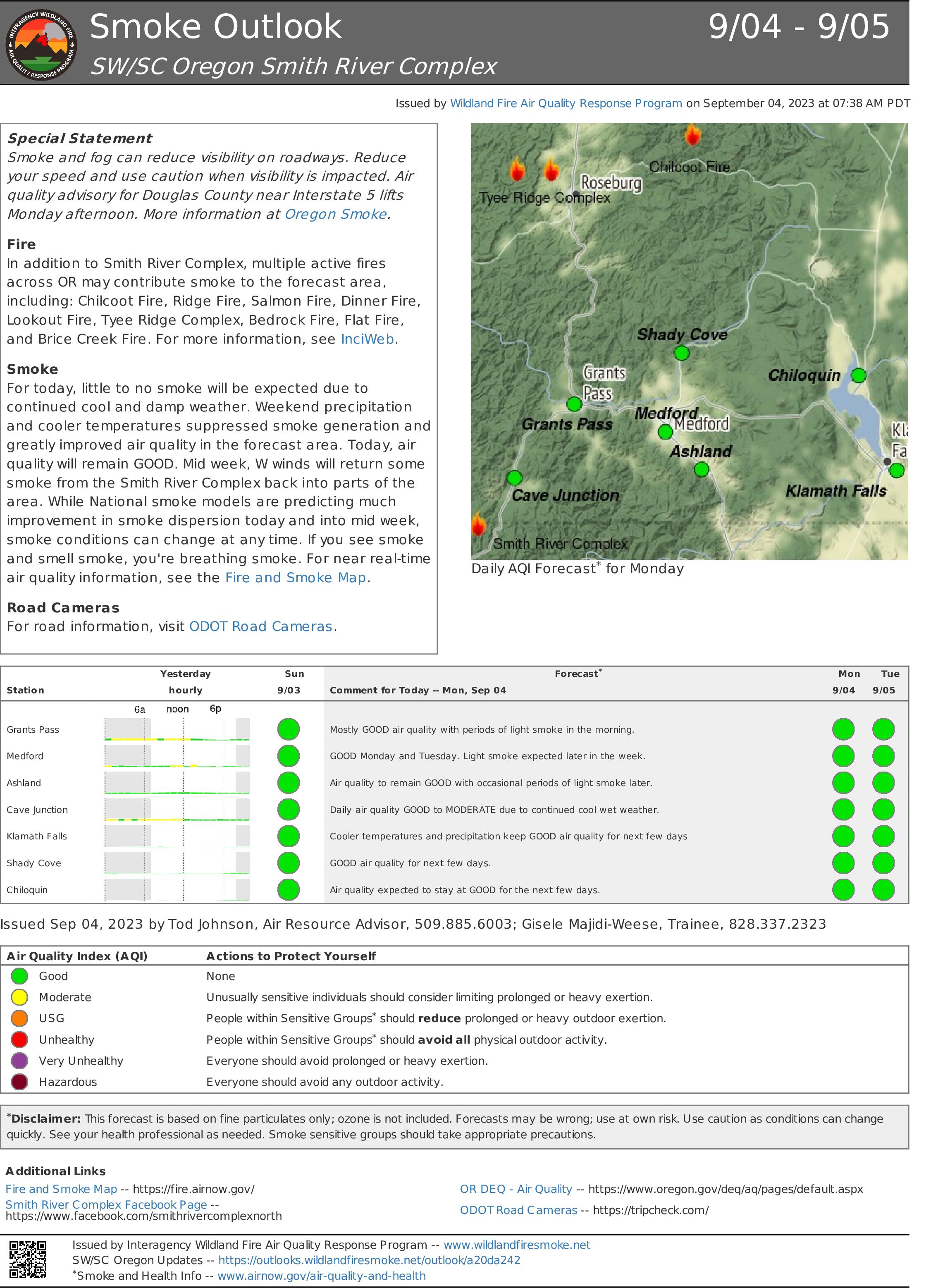
Smoke Outlook 94 95 Smith River Complex
Related Incident: Smith River Complex
Publication Type: News
Special Statement
Smoke and fog can reduce visibility on roadways. Reduce your speed and use caution when visibility is impacted. Air quality advisory for Douglas County near Interstate 5 lifts Monday afternoon. More information at Oregon Smoke.
Fire
In addition to Smith River Complex, multiple active fires across OR may contribute smoke to the forecast area, including: Chilcoot Fire, Ridge Fire, Salmon Fire, Dinner Fire, Lookout Fire, Tyee Ridge Complex, Bedrock Fire, Flat Fire, and Brice Creek Fire. For more information, see InciWeb.
Smoke
For today, little to no smoke will be expected due to continued cool and damp weather. Weekend precipitation and cooler temperatures suppressed smoke generation and greatly improved air quality in the forecast area. Today, air quality will remain GOOD. Mid week, W winds will return some smoke from the Smith River Complex back into parts of the area. While National smoke models are predicting much improvement in smoke dispersion today and into mid week, smoke conditions can change at any time. If you see smoke and smell smoke, you're breathing smoke. For near real-time air quality information, see the Fire and Smoke Map.
Road Cameras
For road information, visit ODOT Road Cameras.
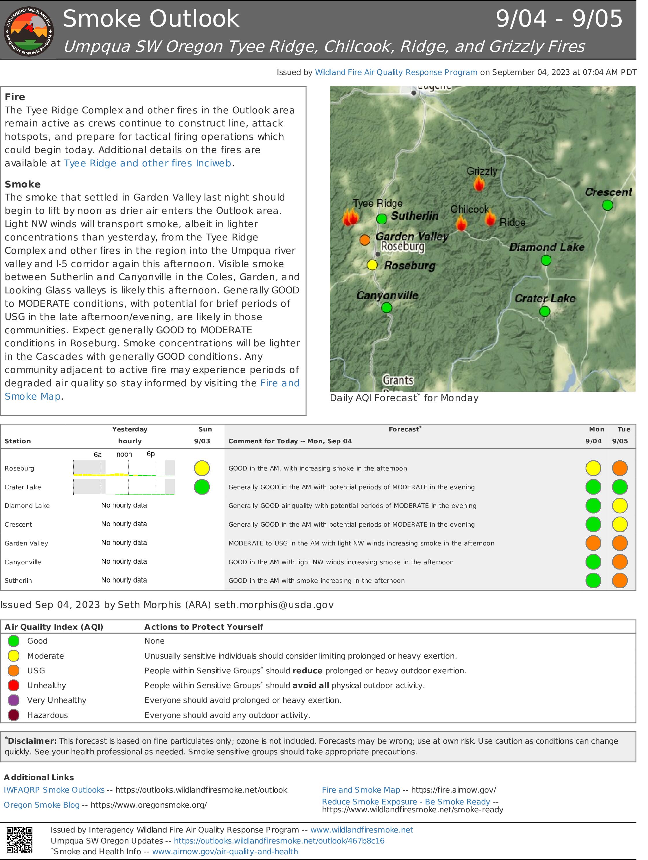
Tyee Ridge Complex Smoke Outlook 09042023
Related Incident: Tyee Ridge Complex
Publication Type: News
Smith River Complex North update September 4 2023
Related Incident: Smith River Complex
Publication Type: News
Smith River Complex North update for Monday, September 4, 2023
GRANTS PASS, Ore. – Today will be the start of a drying trend on the Smith River Complex North. Sunday’s showers may be the last precipitation for an extended period of time. Firefighters are using this period of rain and high fuel moistures to conduct critical work on the fire.
Work has been completed on preparation of the 445 Road for use as a line to stop fire spread to the north. This line ties from the contained portion of the fire by the 461 Road, to where three Hotshot crews are digging lines around a section of the fire that crossed the 4402 Road near the northwest “thumb” of the fire.
Sunday, weather restricted aerial operations most of the day. For the third day in a row, heavy rain, wind, and lightning caused a safety pause for some work on the fire lines. Firefighters needed to move from ridges and other exposed locations to safer places during the worst stormy periods
Personnel and equipment are starting contingency lines north along the 1107 Road toward the Kalmiopsis Wilderness. They are creating a defensible line in case fire pushes northwest. This work is being coordinated with resources from Smith River Complex South.
Firefighters continue to mop-up residual hot spots west of Hwy 199 south of Blue Creek and near Monkey Creek Ridge. Minimal smoke has been visible in this vicinity for several days. Fire personnel also completed work on fire lines east from Hwy 199 southeast to Little Sanger Peak.
Two large hazard trees were identified near Hwy 199 that were likely to reach the highway if they fell. Explosives were used to get these trees down on the ground safely without impacting Hwy 199.
Structural resources completed chipping and mastication operations yesterday. They are wrapping up work in the Illinois Valley and will continue to patrol the area.
Hwy 199 is open, with pilot cars escorting traffic through a one-lane section of the highway impacted by the Smith River Complex. Expect a 30-minute delay. For the latest information on road conditions, please see the Caltrans site and Oregon Department of Transportation's TripCheck site.
Monitor Rogue Valley Emergency Management site and sign up for evacuation alerts and updates at https://rvem.org. An interactive Fire First Response Map showing evacuation areas can also be found there.
Rogue River-Siskiyou National Forest has implemented an area and road closure order for the Smith River Complex. There is a campfire ban in effect for forest lands. Visit the forest website for additional information at https://bit.ly/RRSNFAlerts. The Bureau of Land Management Coos Bay District announced an emergency closure of public lands near the Oregon/California border. For additional information see https://www.blm.gov/orwafire.