
Tyee Ridge Complex Morning Update 090423 Spanish Version
Related Incident: Tyee Ridge Complex
Publication Type: Announcement
Tamaño: 7,257 acres
Contención: 28%
Lomberos están reforzando las líneas y extinguiendo y removiendo material combustible del Tyee Ridge Complex
UMPQUA, Oregon, EE.UU. (AP) — Anoche, los bomberos continuaron reforzando el cortafuego y extinguiendo alrededor de las casas. El dron infrarrojo voló para detectar posibles focos de calor. El clima más favorable anoche trajo lluvia ligera al área, lo que permitió a las cuadrillas continuar su arduo trabajo preparando para que el turno de día tenga éxito.
Hoy, el clima proporcionará más lluvias ligeras hasta temprano por la mañana y se despejará por la tarde. Los cielos claros y el sol contribuirán a que los combustibles se sequen más tarde. Actualmente, la acitividad del fuego se arrastra y arde y puede causar algunos brotes debido al clima cambiante a mitad del día.
Los equipos del Departamento forestal de Oregón continuarán fortaleciendo el cortafuego al mejorar las líneas y mitigando los peligros de los árboles para la seguridad de los bomberos. Los helicópteros estarán trabajando hoy, dejando caer agua en las partes más activas del fuego. Los cielos más claros los ayudarán con este trabajo. La protección de estructuras está en su lugar si llega a haber necesidad a medida que los bomberos extinguen y remueven material combustible alrededor de las casas. Los recursos de ataque inicial estarán disponibles para cualquier nuevo inicio que ocurra en el área.
Hoy pudieran realizarse operaciones de quema táctica y los planes están sujetos a cambios si no se producen condiciones climáticas favorables. El clima de esta noche traerá aire más fresco y un retorno de mayor humedad.
El roble venenoso es un peligro en el campo. La información de concienciación de seguridad sobre esta planta se ofrece tanto en español como en inglés para todas las cuadrillas. Tecnu y Zanfel, que son diferentes tipos de lavados, se están proporcionando como tratamiento.
Para ver el mapa de información de evacuación actual, vaya a www.dcso.com/evacuations. Para albergar ganado, comuníquese con el Control de animales del condado de Douglas al 541-440-4471. Las mascotas de compañía pueden ser refugiadas en el centro de adopción de mascotas Saving Grace en Roseburg.
Departamento forestal de Oregón
Joe Hessel, Comandante del incidente
Brice Creek Dinner and Grizzly Fires Daily Update September 4 2023
Related Incident: Brice Creek FireDinner FireGrizzly Fire
Publication Type: News
Brice Creek, Dinner, and Grizzly Fires
September 4, 2023
Daily Fire Update
Brice Creek, Dinner, and Grizzly Fires
Total personnel: 647 | Total Resources: 13 engines; 25 crews; 2 helicopters; 3 heavy equipment; 7 water tenders
Moisture and precipitation on the fires last night continues to moderate fire behavior with little to no new growth on the fires.
Brice Creek Fire: Size: 583 acres | Start Date: August 24, 2023 | Cause: Lightning | Containment: 15%
Fire crews continue to improve indirect lines along the north side where fuels were not fully consumed. Additionally, several spur roads will be improved as alternate and contingency lines. Heavy equipment and fire crews will be prepping line along Noonday Ridge. Other areas of the fire will further secure the perimeter mopping up, monitoring for smoke, and patrolling for rollout to prevent any spot fires from igniting.
Dinner Fire: Size: 304 acres | Start Date: August 24, 2023 | Cause: Lightning | Containment: 50%
Yesterday dozer line was established on the northeast perimeter adding to containment. Firefighters removed more snags and excavators and chippers continue to clear woody debris along roads. Mop-up operations are on-going and resource advisors are assessing fire suppression repair work needs that will begin today.
Grizzly Fire: Size: 100 acres | Start Date: August 24, 2023 | Cause: Lightning | Containment: 0%
Over the past several days, fire managers diligently scouted for areas to establish effective direct lines, but could not mitigate the hazards to firefighter safety due to the inaccessible, steep, and remote location. Firefighters have cleared vegetation to create fuel breaks and improved roads. Structure protection tactics in the Crystal Lake area including clearing overgrown vegetation, setting up sprinkler systems, and wrapping structures have been largely completed.
Weather: Temperatures will be 55-65 with minimum relative humidity in the 50s. Winds will be west-northwest gusting to 15 mph, similar to yesterday. There is a chance of showers in the morning.
Evacuations: Lane County issued a Level 2 Evacuation (Be Set) for all private lands and mining claims in the Bohemia areas within the Cottage Grove Ranger District of the Umpqua National Forest.
Safety and Closures: There is a forest closure for portions of the Umpqua National Forest in response to fire activity in the area to protect public and wildland firefighter safety. There is a Temporary Flight Restriction over the fire area. Please use extra caution while driving this holiday weekend. Expect to see an increase in traffic, fire apparatus, and heavy equipment with a potential for wet roadways and fog.
Brice Creek Fire Inciweb: https://inciweb.wildfire.gov/incident-information/orupf-brice-creek-fire
Dinner Fire Inciweb: https://inciweb.wildfire.gov/incident-information/orupf-dinner-fire
Grizzly Fire Inciweb: https://inciweb.wildfire.gov/incident-information/orupf-grizzly-fire
Facebook: https://www.facebook.com/bricecreekdinnergrizzlyfires2023/
Fire Information: (541) 900-5862, 8:00 AM – 7:00 PM Email: 2023.dinner@firenet.gov
Petes Lake Fire Update September 4 2023
Related Incident: Petes Lake Fire
Publication Type: News
Resources: 229 Total Personnel | 3 Hand Crews | 4 Dozers | 4 Helicopters |9 Engines | 6 Masticators | 2 Water Tenders
Central Oregon – The Petes Lake Fire was started by a lightning strike on Friday, August 25, near the border of the McKenzie River Ranger District of the Willamette National Forest and the Bend Fort-Rock Ranger District of the Deschutes National Forest in the Mink Lake Basin area of the Three Sisters Wilderness. The fire has burned 320 acres and is burning in the Willamette National Forest five miles west of Elk Lake.
Fire behavior has been minimal with the remaining hot spots creeping and smoldering in the Wilderness area. Along the Cascade Lakes Highway between Lava Lake and Elk Lake, hand crews and heavy equipment operators continue to remove a portion of the trees and slash within 200’ from the edge of the road. Removing these combustible materials helps strengthen fire control features that could save structures and other values at risk.
The planned construction length of this shaded fuel break is 9.7 miles and 6% has been completed so far. This important fuel reduction work is based on specific tree spacing. In addition, it will help protect the area from wildfire for many years. The work along the Cascades Lake Highway is expected to continue for several more days, but drivers will have the option of driving the Elk Loop detour (River Summit Drive to Highway 40).
The heavy equipment requires occasional use of the highway to fell trees and transport brush to temporary landings, where the slash is processed, loaded and hauled off. The masticators fling wood debris and cannot be operated safely near traffic. By using heavy equipment to create the shaded fuel break, the risk of injury to hand crews when felling trees is minimized.
Today, similar to the previous two days, a marked pilot car will be used to guide vehicles through the work area. Motorists are asked to stay with the pilot car and not turn around or stop for photos. Cooperation from the public will help fire crews and equipment operators get this work done safely and with minimal impact to local businesses.
Weather: Today, there could be light rain in the morning, but the relative humidity is predicted to drop in the afternoon. Looking ahead to Tuesday and Wednesday, the weather is expected to be drier and more typical for this time of year. Less cloud cover and warmer, drier conditions increase the likelihood of increased fire activity.
Evacuations: The Deschutes County Sheriff lifted the Level 1 Evacuation Notice for the areas east of the Cascade Lakes Highway around Elk and Lava Lakes. The Level 3 (Go Now) Evacuation Notice is still in place for all areas west of the Cascade Lakes Highway from the Lucky Lake Trailhead north to the Mirror Lake Trail. This includes the areas around Lucky Lake, Leech Lake, Doris Lake, Blow Lake and Mirror Lakes. Evacuation notices and updates can be found at: www.deschutes.org/emergency.
Closures: The closure order on the Willamette and Deschutes National Forests for the Petes Lake Fire remains in place and information can be found at: fs.usda.gov/detail/deschutes/news-events/?cid=FSEPRD1134682. Resorts along the Cascade Lakes Highway remain open for business, though visitors may encounter delays with road flaggers and pilot cars. Wanoga and Kapka SnoParks are being used by firefighting resources and closed to the public.
Safety: The public can help by obeying the National Forest trail closures. There will be a stronger law enforcement presence in the area to enforce trail closures and help firefighters continue their work safely. Be aware of your surroundings and follow all fire restrictions.
2023 SRF Lightning Complex and Redwood Lightning Complex Fires Supplement 90423
Related Incident: 2023 SRF Lightning Complex and Redwood Lightning Complex
Publication Type: News
Complex Overview (Supplement to Daily Fire Update)
2023 SRF Lightning Complex & Redwood Lightning Complex
Updated September 4, 2023
Rocky Mountain Complex Incident Management Team 1
Dan Dallas, Incident Commander
Information Phone: 530-536-0767
Email: 2023.lightningcomplex@firenet.gov
Information Staffing Hours: 8 am to 8 pm
Overview: On the evening of August 15, the Six Rivers National Forest and Redwood National and State Parks received 150 lighting strikes across the area spanning almost 1 million acres. After the significant lightning event there were 27 confirmed fires. On Saturday, September 2, 2023, Rocky Mountain Complex Incident Management Team 1 assumed command of 19 fires that remained uncontained within the complex.
Click on the following hyperlink to see a list of the fires that are included in the 2023 SRF Lightning Complex and Redwood Lightning Complex.
Evacuations
There are evacuation warnings in the areas listed below. Anyone in an evacuation warning area should be prepared for potential evacuations, including packing personal supplies, and arranging overnight accommodations. Being ready to go at a moment's notice.
Pearch Fire Evacuation Warnings: Zone HUM-E009 (Southeast of the Klamath River in Orleans); Zone HUM-E008-B (Community of Orleans, west of Klamath River. East of Crawford Creek, including Orleans proper). Hwy 96 and Red Cap Road along the east bank of Klamath River, south from Salmon River, east to Orleans Mountain. Approximately 243 residents live in these two zones.
Siskiyou County Evacuation Warnings: Zone SIS-1701: NORTH of Monte Creek Road, SOUTH of Camp Three Road, EAST of Camp Three Road, WEST of Wooley Creek Trailhead. In addition, zones SIS-1515, and SIS-1518 are currently under evacuation warnings.
NOTE: There are currently no evacuation orders in place due to fire activity in this complex, but an evacuation order is in place for the area near the Cooper Fire (SIS-1402) due to the Elliot Fire which is part of the Happy Camp Complex.
Closures
Six Rivers National Forest: Area and campground closures are in effect on portions of Six Rivers National Forest. They can be found at: https://www.fs.usda.gov/detail/srnf/notices/?cid=FSEPRD1096395.
Redwood National Park and State Park: There are multiple closures in the parks due to several fires, including closures in the Lost Man area. For a full list of closures and impacts, please visit: www.nps.gov/redw/planyourvisit/conditions.htm.
Alert Notifications
ZoneHaven/Genasys for map and zone identification: https://protect.genasys.com .
Humboldt County Residents Register for Humboldt Alert Notification: www.humboldt.gov/alerts
Siskiyou County Resident Register at Code Red Alert Notification: https://public.coderedweb.com/CNE/en-US/6F327CCDFFFD.
Additional Fire Information
InciWeb: https://inciweb.nwcg.gov/incident-information/casrf-2023-srf-lightning-complex
Facebook: https://www.facebook.com/2023SRFRedwoodLightning
Redwood National and State Parks Information Hotline: Phone: 707-464-6101
https://www.nps.gov/redw/planyourvisit/conditions.htm
Hoopa Information Hotline: Phone: 530-618-2995 | Email: serene.oes@gmail.com
More Fire Information Links: www.linktr.ee/srffirepio
Bosque Nacional Seis Ros Complejo Smith RiverSur Lunes 4 de Septiembre de 2023
Related Incident: Smith River Complex
Publication Type: News
Fecha de inicio: 15 de Agosto
Ubicación: Bosque Nacional Six Rivers
Causa: Relámpagos
Acres: 85,429
Contención: 19%
Personal: 2,642
Situación Actual: Ayer, los bomberos trabajan en todas las áreas alrededor de la Zona Sur del incendio. Los equipos aprovecharon el tiempo y la humedad en el área para mejorar las líneas de contenido. También, los equipos se están preparando para hacer operaciones a usar fuego a mejorar las líneas de contenido a finales de esta semana.
En el lado noroeste del incendio, los supervisores de operaciones del Southwest Area Team 2 están trabajando estrechamente con sus correspondientes de la Zona Norte del Pacific Northwest Team 13 para construir una estrategia unificada de extinción de incendios. Al mismo tiempo, los equipos de bomberos en Gasquet están desmantelando el exceso de equipo de protección de estructuras que tienen ahí, y están dejando el equipo necesario para la protección continua de la comunidad de Gasquet. Los bomberos también están disponibles para responder rápidamente a cualquier nuevo incendio, si eso pasa. Durante la noche, tenemos bomberos patrullando y vigilando el perímetro del incendio. También, los helicópteros y UAS asignados al incidente están ayudando con misiones de reconocimiento, utilizando la tecnología infrarroja para ayudar a localizar puntos críticos dentro del perímetro del incendio.
Condiciones Climáticas y de Combustibles: El sistema meteorológico responsable de las lluvias recientes se ha desplazado hacia el este. Los cielos despejados, los vientos del oeste y las temperaturas en aumento gradual y los niveles de humedad en disminución persistirán durante toda la semana. Sin embargo, el potencial de un comportamiento y crecimiento significativo del fuego sigue siendo bajo porque la vegetación retendrán algo de humedad residual.
Perspectiva de humo: La producción de humo desde el incendio siga siendo mínima este lunes. La información sobre la calidad del aire está disponible en español https://outlooks.wildlandfiresmoke.net/outlook/es/0e644879
Restricciones/Cierres: US-199 ahora está ABIERTA a todo el tráfico. Sin embargo, un segmento de 8 millas entre Sandy Beach (cerca de marcador de milla 21) y Knopke Creek (cerca de marcador de milla 29), tiene control de tráfico pilotado y unidireccional. Hay retrasos posibles de 20 a 40 minutos. El segmento pilotado se expandirá o contraerá a medida que los bomberos reparen las barandillas quemadas, retiren las rocas de la carretera y eliminen los árboles peligrosos.
Los terrenos, caminos y senderos del Bosque Nacional Six Rivers que rodean el Complejo de este incendio están cerrados (Orden Forestal No. 10-23-06). Se puede ver el mapa de orden y cierre en esta página web del Bosque Nacional Six River: https://www.fs.usda.gov/detail/srnf/notices/?cid=FSEPRD1096395
Evacuaciones: Las órdenes de evacuación emitidas por la Oficina del Sheriff del Condado de Del Norte siguen vigentes para las siguientes áreas:
· NIVEL 3, GO/ Vaya ahora: Rockland
· NIVEL 2, Get Set/ Prepárese: Rowdy Creek/Low Divide, Gasquet, Big Flat/Rock Creek, Patricks Creek Lodge, Little Jones/Washington Flat Residential Areas, Oregon Mountain Road Area, Sun Star
· NIVEL 1, Get Ready/ Esté preparado: Hiouchi
Vea el mapa de evacuación interactivo en línea para conocer las evacuaciones más recientes: https://bit.ly/45zDbZF. Regístrese en el Sistema de Alerta Comunitaria del Condado de Del Norte para recibir notificaciones de emergencia por teléfono fijo, mensaje de texto por teléfono celular o correo electrónico: https://member.everbridge.net/index/892807736723128#/signup
Información sobre incendios: 2023.smithrivercomplex@firenet.gov
Facebook: https://www.facebook.com/SixRiversNF
Happy Camp Complex Incident Update September 4 2023 Morning
Related Incident: 2023 Happy Camp Complex Klamath NF
Publication Type: News
VIRTUAL PUBLIC MEETING: A virtual public meeting for the Happy Camp Complex will be held on Tuesday, September 5th, at 5:30 p.m. Fire personnel will provide an operational overview of the fire situation. The meeting will be live-streamed on Facebook (facebook.com/KlamathNF) and YouTube (youtube.com/@ciimt5). A Facebook account is not necessary to view the meeting.
WEATHER: A forecasted warming trend and dry conditions are expected on the Happy Camp Complex this week. Warmer weather and increased will affect smoke conditions and air quality.
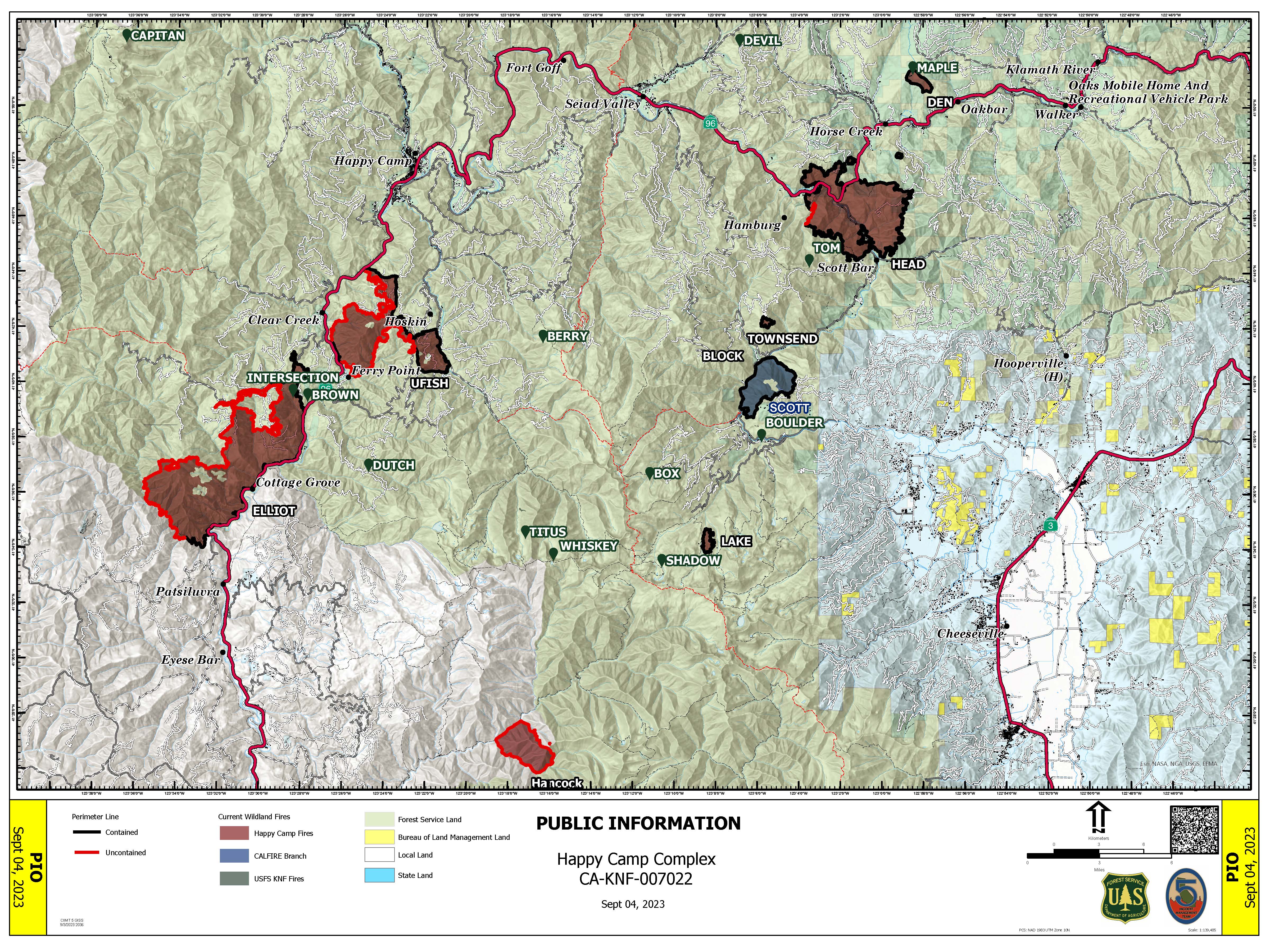
WEST SIDE OVERVIEW (ACRES/CONTAINMENT): Elliot (12,104 acres, 51%), Ufish (5,036 acres, 33%), Hancock (1,720 acres, 0%)
Minimal fire activity was observed on the Happy Camp Complex last night. The Elliot Fire is holding at State Route 96. Today, firefighters will be looking for opportunities to build more fire line on the western edge towards Dillon Creek. Crews on Ufish will be prepping unburned areas for potential strategic firing operations to protect the Highway 96 corridor. The fire is currently holding at Titus Creek. Yesterday, smokejumpers and fire line supervisors were flown to the Hancock Fire to assess and prepare the area to support additional fire crews. Due to the challenging terrain of the fire located in the Marble Mountain Wilderness, firefighters are being supported by aerial resources.
EAST SIDE OVERVIEW (ACRES/CONTAINMENT): Head (6,940 acres, 91%), Block (0.1 acres, 100%), Townsend (81 acres, 100%), Den (294 acres, 100%), Scott (1,886 acres, 100%), Lake (199, acres, 100%)
Today, firefighters will continue to secure the last section of open fire line and the suppression repair work on the Head Fire. Patrol and mop up will be ongoing for both the Scott and Head fires today. Due to progress made in containment on the east side of the Happy Camp Complex, crews will be moving equipment to higher priority areas of the complex. As of yesterday, the Scott Fire is 100 percent contained.
EVACUATIONS: View current Siskiyou County evacuation orders and warnings by visiting: www.community.zonehaven.com. Siskiyou County residents are encouraged to sign up for rapid emergency notifications using the CodeRED emergency alert system at: www.co.siskiyou.ca.us/emergencyservices/page/codered-emergency-alert
ROAD CONDITIONS: No road work will be performed on State Route 96 through Wednesday, September 6th, at 7 a.m., to allow for holiday travel. Please keep in mind that one-way traffic control will remain in place from 2.8 miles west of Dillon Road to 8.8 miles east of Dillion Road, as this remains in an active fire area for the Elliot Fire. Motorists can expect up to 30-minute delays in this area. County road closures will be listed on the Siskiyou County Public Works website: www.co.siskiyou.ca.us/publicworks/page/closures-and-delays
FOREST CLOSURES: Two closure orders have been implemented: Happy Camp Complex Emergency Fire Closure No. 05-05-23-06 and No. 05-05-23-08. Additionally, fire restrictions remain in place to help minimize the chances of human-caused wildland fires. These restrictions prohibit campfires outside of designated improved recreation areas and wilderness. View closure orders, fire restrictions, and maps at: www.fs.usda.gov/alerts/klamath/alerts-notices
TEMPORARY FLIGHT RESTRICTION (TFR): A TFR has been established over the fire area. Flight restrictions include the use of drones. The operation of drones under the TFR is prohibited.
PACIFIC CREST TRAIL: The Pacific Crest Trail is now open between the Shelly Fork Junction and Seiad.
AIR QUALITY: For information regarding smoke impacts and what you can do to protect yourself, visit the Siskiyou County Air Pollution Control District Fire and Smoke Information website at: www.co.siskiyou.ca.us/airpollution/page/fire-and-smoke-information or AirNow.gov
2023 SRF Lightning Complex and Redwood Lightning Complex Update 90423
Related Incident: 2023 SRF Lightning Complex and Redwood Lightning Complex
Publication Type: News
Fire Update
2023 SRF Lightning Complex & Redwood Lightning Complex
Monday, September 4, 2023 – 9:00 a.m.
Rocky Mountain Complex Incident Management Team 1
Dan Dallas, Incident Commander
Information Phone: 530-536-0767
Email: 2023.lightningcomplex@firenet.gov
Information Staffing Hours: 8 am to 8 pm
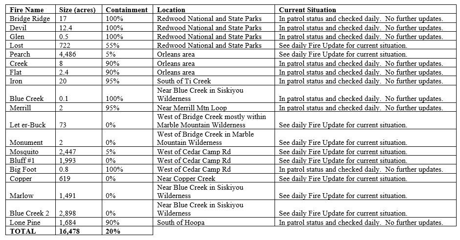
Special Note: This update covers 9 of the 19 fires currently being managed as part of the Complexes plus one new initial attack fire. The remaining 10 fires are listed in the accompanying Complex Overview. Those fires, totaling 1,746 acres, are contained and in patrol status. They are checked daily, and their size and containment status are unlikely to change.
Current Situation: The 19 fires in this incident total 16,478 acres and overall containment is 20%. The nine uncontained fires described below total 14,731 acres. Hog Fire and Lost Fire are in Redwood National and State Parks. All other fires described in this update are in Six Rivers National Forest.
Hog Fire (0.2 acres) – This is a new fire detected on Saturday in the southern end of the National Park. It was an initial attack assisted by the Rocky Mountain team and is not an official part of the Complex. The fire is a lightning strike in a single cedar tree. The burning tree has been felled and the fire is lined and in mop up status.
Lost Fire (722 acres, 55% contained) – Indirect line construction has been completed on the north side of the fire in Division AA. A short portion of the fire perimeter in the northwest corner is too steep and rocky to safely put firefighters in. The current focus of activity on this fire is backhaul of unneeded equipment for use in other areas.
Pearch Fire (4486 acres, 5% contained) – Crews are continuing to mop up and secure firelines in the southeast portion of the fire in Division Z and to improve lines in the southwest corner in Division J. No additional firing operations are planned on the fire at this time. The structure protection group is conducting structure assessments along the Salmon River corridor to the east of the fire in Division Y. These will be compiled into a product that will be useful to local agencies in the event of any future emergencies. Hoses, sprinklers, and other structure equipment have been deployed in some locations as a preventative measure,
Bluff #1 (1993 acres, 0% contained) and Mosquito (2447 acres, 5% contained) Fires – Mastication on an indirect fireline north of Mosquito Fire is done and chipping occurred yesterday. A dozer line along a portion of Bean Ridge has been cleaned up, and hand crews will extend the line further northeast to Highway 96. The east side of Mosquito Fire is contained by direct line along the Cedar Camp Road in Division M. An indirect line has been completed westward from the southeast corner of Mosquito Fire in Division M. Mastication has been completed along an indirect line that runs from north of Bluff #1 Fire, along the west side of that fire, and southward in Division N. The plan is to connect the south end of this line to the line running west of Mosquito Fire with handline starting today. Four chippers will be working to remove slash from the masticated indirect lines, with an expected four days of operations needed.
Blue Creek #2 (2898 acres, 0% contained), Marlow (1491 acres, 0% contained), and Copper (619 acres, 0% contained) Fires – These fires are being patrolled by aerial resources as weather conditions allow. They are bounded by indirect control lines to the east and south, and significant movement of these fires is not expected.
Monument (2 acres, 0% contained) and Let er-Buck (73 acres, 0% contained) Fires – Due to limited values at risk, the remote, steep terrain and associated safety concerns for our firefighters, and the low probability of success using standard suppression tactics, these fires are being addressed with a confinement strategy. Terrain, natural fire barriers such as rock outcroppings, and old fire footprints where fuels are limited will be used to confine fire growth until season ending precipitation extinguishes the fires. These fires are checked regularly by aerial patrols to ensure they remain within acceptable bounds, and little to no fire growth has been observed.
Weather: Following 0.5 to 0.75 inches of rain across the Complexes over the past few days, today will bring a 10% chance of precipitation with decreasing clouds. A warming, drying trend begins today and will intensify over the next several days. Temperatures will be seasonal in the 60s and 70s. Winds will be light from the west.
For information on Closures, Evacuations, and Alert Notifications please see the accompanying Complex Overview.
Fire Information Contacts
Phone: 530-536-0767 | Email: 2023.lightningcomplex@firenet.gov
InciWeb: https://inciweb.nwcg.gov/incident-information/casrf-2023-srf-lightning-complex
Facebook: https://www.facebook.com/2023SRFRedwoodLightning
Redwood National and State Parks Information Hotline: Phone: 707-464-6101
https://www.nps.gov/redw/planyourvisit/conditions.htm
Hoopa Information Hotline: Phone: 530-618-2995 | Email: serene.oes@gmail.com
More Fire Information Links: www.linktr.ee/srffirepio
Community Meeting to be held on Wednesday September 6
Related Incident: Camp Creek Fire
Publication Type: Announcement
A community meeting is scheduled for 6:30 p.m. Wednesday evening, September 6th, to answer questions and listen to concerns about the Camp Creek Fire.
The community meeting will be held at the Mt. Hood Lions Club at 24730 E. Woodsey Way in Welches.
We will attempt to livestream the meeting on Facebook at the following link: https://www.facebook.com/campcreekfire
Tyee Ridge Complex Morning Update 090423
Related Incident: Tyee Ridge Complex
Publication Type: Announcement
Acreage: 7.257
Containment: 28%
Firefighters Securing Lines and Mop Up on Tyee Ridge Complex
UMPQUA, Ore. – Last night, firefighters continued to secure the fireline and mop up around homes. The infrared drone flew to detect potential hotspots on the fire. More favorable weather last night brought light rain to the area allowing crews to continue their hard work setting up the day shift for success.
Today, the weather will provide more light showers through the early morning with clearing in the afternoon. Fair-weather skies and sun will contribute to fuels drying out later in the day. Currently, the fire behavior is creeping and smoldering, and with shifting weather during the middle of the day may cause some flare ups.
Oregon Department of Forestry crews will continue to secure the fireline by improving lines and mitigate tree hazards for firefighter saftey. Helicopters will be working today, dropping water on the more active parts of the fire, clearer skies will assist them in these efforts. Structure protection is in place if there is a need as firefighters mop up around homes. Initial attack resources will be available for any new starts occuring in the area.
Tactical firing operations may take place today and plans are subject to change if favorable weather conditions do not occur. Tonight’s weather will bring cooler air and a return of increased humidity.
Poison oak is a hazard in the field. Safety awareness information about this plant is offered in both Spanish and English for all crews. Tecnu and Zanfel, which are different types of washes, are being provided as treatment.
To view the current evacuation information map, go to www.dcso.com/evacuations. To shelter livestock, contact Douglas County Animal Control at 541-440-4471. Companion pets can be sheltered at Saving Grace Pet Adoption Center in Roseburg.
Oregon Department of Forestry
Joe Hessel, Incident Commander
Lookout Bedrock Horse Creek Pothole Fires Daily Update 942023
Related Incident: Lookout FireBedrock Fire2023 Horse Creek Fire
Publication Type: News
Lookout/Horse Creek/Pothole Fires/Bedrock
September 4, 2023
Morning Update
ALERT: There may be short closures on Highway 126 as firefighters are removing fire damaged hazard trees.
Lookout: Total Personnel: 701
Size: 24,581 acres l Start Date: August 5, 2023 l Cause: Lightning l Containment: 20%
Resources: 32 engines l 14 crews l 7 bulldozers l 29 water tenders l 8 masticators l 6 helicopters l 1 Skidder
The eastern side of the fire received light rain Sunday morning, resulting in minimal fire activity. Today, steep terrain on the western flank will be worked by Hot Shot crews to secure the fires edge. Crews will continue to prepare contingency lines, and work on hot spots throughout the fire area. Smoke will continue to impact the McKenzie drainage along Highway 126.
Horse Creek: Total Personnel: 192
Size: 765 acres l Start Date: August 24, 2023 l Cause: Lightning l Containment: 12%
Resources: 18 engines l 4 crews l 4 bulldozers l 9 water tenders l 2 masticators l 2 Skidders l 2 Excavators
Yesterday firefighters patrolled the fires edge and continued strengthening and improving completed fire lines. Significant heat from burning, dead and down heavy fuels remain on the eastern side of the fire in steep rugged terrain. Crews will continue extinguishing and removing burning material along completed fire lines, and patrolling along roads.
Pothole: Total Personnel: 90
Size: 109 acres l Start Date: August 25, 2023 l Cause: Lightning l Containment: 15%
Resources: 7 engines l 1 crews l 1 bulldozers l 4 water tenders l 1 Masticator l 3 Skidders
There was little fire activity yesterday allowing firefighters to make good progress on containment. Today Firefighters will maintain established fire lines and continue to secure the perimeter.
Bedrock: Total Personnel: 419
Size: 31,590 acres l Start Date: July 22, 2023 l Cause: under investigation l Containment: 85%
Resources: 18 engines l 12 crews l 5 bulldozers l 18 water tenders l 7 masticators l 6 helicopters l 4 Skidder
On the north side of the fire, crews have been chipping brush, removing and processing logs to help reduce fuel loads. The suppression group will continue to work on uncontained lines, provide initial attack capabilities, and continue to assist the Willamette National Forest with nearby fires. Excess fire equipment continues to be removed and returned to base camp for servicing and cleaning.
All Fires
Recent rains, higher humidity, and cooler temperatures have combined to moderate the burning intensity and slowed the fires growth. However, this has resulted in smoldering and creeping fire that is conducive to increased smoke development. Valleys, drainages, and transportation corridors may be subjected to periods of dense smoke. Smoldering fire will continue to weaken standing trees, creating an extreme hazard to firefighters and equipment.
Weather
The weather pattern that has been in place will continue for at least one more day. The rain has allowed firefighters to make good progress on all fires. Fire activity is expected to be minimal today as the weather remains cool and relatively humid.
Evacuation Centers: An evacuation center is in place at Westridge Middle School in Oakridge for evacuees and small pets from the Horse Creek and Lookout Fires. For assistance with large animal evacuations, please call 541-285-8227.
Evacuation Update: There is potential for reducing evacuation levels in several zones over the next few days.
Additional information can be found at the following websites.
Lane County Evacuations: https://www.lanecountyor.gov/cms/one.aspx?pageId=19729054
Linn County Evacuations: https://www.linnsheriff.org/
Road Closures:
Highway 242, McKenzie Highway, is closed between milepost 61-76, 14 miles west of Sisters, Oregon to just east of the junction with Highway 126. Highway 126 is currently open. Please monitor Trip Check for any updates at: https://tripcheck.com/
Forest Closures: Willamette National Forest reduced the closure area for the Bedrock fire due to successful firefighting efforts. Many popular sites and trails have re-opened including the Alpine Trail. There are no changes to closure areas for the Lookout, Horse Creek, and Pothole fire areas at this time. These closures help provide firefighters with safer driving conditions and decrease the potential for search and rescue operations that could interrupt firefighting activities. Closures can be found at: https://www.fs.usda.gov/detail/willamette/alerts-notices/?cid=fseprd552029
Restrictions: Fire Restrictions are in place on the Willamette National Forest: https://www.fs.usda.gov/willamette. Temporary Flight Restrictions remain in place over the Bedrock and Lookout fire areas.
Smoke Outlook: https://outlooks.wildlandfiresmoke.net/outlook/4c92bc1a The Fire and Smoke Map (fire.airnow.gov) is another source for air quality information.
Lookout Information Line: 541-215-6735 (8 a.m. - 8 p.m.)
Email: 2023.lookout@firenet.gov
Facebook: https://www.facebook.com/LookoutFire2023
Inciweb: https://inciweb.nwcg.gov/incident-information/orwif-lookout-fire
Bedrock Fire Information: 541-414-6272 (8 a.m. - 8 p.m.)
Email: 2023.bedrock@firenet.gov
Facebook: https://www.facebook.com/BedrockFire2023/
InciWeb Bedrock: https://inciweb.wildfire.gov/incident-information/orwif-bedrock-fire