
Update Chilcoot and Ridge Fires September 4 2023
Related Incident: 2023 Ridge Fire UNF2023 Chilcoot Fire UNF
Publication Type: News
CHILCOOT AND RIDGE FIRE UPDATE
Monday, September 4, 2023
Chilcoot Fire: Size: - 1,762 acres, Containment: 5%
Ridge Fire: Size - 238 acres, Containment: 72%
Rainfall over the last couple of days has decreased the fire activity. Smoldering and creeping continue in the heavy duff layer under mature timber. Crews are going direct on fire lines where accessible to improve control lines and work with natural resources personnel to improve contingency operations. As California Incident Management Team 12 transitions operational command to Northwest Team 12, appreciation has been expressed to the crews, agencies and the community for support, collaboration, and incredible teamwork. Operations will continue as planned with containment continuing to grow.
Chilcoot Fire - Solid progress is being made on the western flank of the fire, connecting dozer and control lines with direct line. Firefighters will continue to patrol, mop up and secure this area. Containment around this area is expected to increase significantly within the next few days. Firefighting crews are taking advantage of old roads to access the northeast edge of the fire and will work to tie into the already completed handlines across much of the northern perimeter. Existing roads and control lines continue to be strengthened from the 3806 road to Hipower Creek for direct attack along the fire line.
Ridge Fire - Minimal fire activity allows for firefighters to extend further along the fire perimeter, allowing crews to extinguish burning material. As the containment line grows, resources will be reallocated to the Chilcoot fire.
Weather - Temperatures will remain on the cool side of normal through tomorrow. Today will be mostly cloudy with a chance of showers. Highs 60-70. Relative humidity 55-65%. Winds: NW 5-10.
Evacuations
No current evacuations.
Closures
- Closure Order (06-15-00-23-475) in the Umpqua NF has been established. The order is effective from Aug 28, 2023 – Dec 1, 2023. For full order go to Umpqua National Forest - Alerts & Notices (usda.gov)
- A Closure Order for the Canton Creek area has been issued by Bureau of Land Management (BLM) Chilcoot Ridge Fire EMERGENCY CLOSURE ORDER BLM Roseburg District
- Temporary Flight Restrictions can be found at https://tfr.faa.gov/tfr2/list.jsp
Additional information
- Facebook: https://www.facebook.com/profile.php?id=61550481586772
- Twitter: https://twitter.com/UmpquaNF
Happy Camp Complex Virtual Public Meeting Wednesday September 6 2023 530 pm
Related Incident: 2023 Happy Camp Complex Klamath NF
Publication Type: Announcement
The Happy Camp Complex will hold the next virtual public meeting and fire operations update on Wednesday, September 6, 2023 at 5:30 pm.
Fire personnel will provide an operational overview of the fire situation.
The meeting will be live-streamed on both Facebook and YouTube.
- Facebook at https://facebook.com/KlamathNF
- YouTube at https://YouTube/@ciimt5
Ridge Creek Fire Daily Update September 4 2023
Related Incident:
Publication Type: News
Location: Approximately 3.5 miles east of the north tip of Hayden Lake, along the Hayden Creek Road (Forest Service Road 437) from the Ridge Creek drainage to South Chilco Mountain.
Start Date: 8/3/2023
Cause: Human-caused
Size: 4,474 acres
Containment: 51%
Total Personnel: 163
Crews: 3
Pieces of Equipment: 15-this includes a processor, log truck, loaders, excavators, dozers, skidders, feller bunchers and 3 chippers.
John Heyn’s North Idaho Type 3 Team took command of the Ridge Creek Fire from the Southern Area Gold Team on September 3, 2023, at 6:00pm.
The North Idaho Team, Idaho Department of Lands and the Idaho Panhandle National Forest thank the Southern Gold and Eastern Silver Teams for their support of fire suppression efforts. With the transition to the North Idaho Team, the incident command post has moved from Farragut State Park to the Kootenai County Office of Emergency Management.
All fire restrictions have been lifted for the Idaho Panhandle National Forest. While campfires are no longer restricted, hunters and recreationists are urged to continue to use caution. Never leave a campfire unattended, and make sure it is cold to the touch before walking away. Please visit https://www.idl.idaho.gov/fire-management/fire-restrictions-finder for a detailed map and current information regarding fire restrictions across the state.
FIRE STATUS
With holiday traffic, motorists are advised to watch for firefighting equipment on the roadways.
Yesterday, the North Idaho Team shadowed the Southern Gold Team. Firefighters continue to mop up hot spots and repair handlines, while excavators, chippers, graders and dump trucks worked to repair dozer lines and roads. A few isolated hot spots remain that are located within the northern perimeter of the fire near South Chilco Mountain, which posed no threat to further spread.
Specific areas of work included grading on USFS Road 1511 east of Spades Mountain, excavator work on the 406M Road, chipper work on the 625 and Bunco Roads and dump truck and front-end loader work to repair potholes on the 437 Road.
WEATHER AND FIRE BEHAVIOR
Today, will be mostly cloudy with a 50 percent chance of showers and a high near 65. South winds will be around 10 mph. New precipitation amounts of less than a tenth of an inch is possible. Relative humidity will range from 50-70%.
Live and dead vegetation remains damp from recent rainfall and active flames are unlikely. Minimal fire behavior is expected as fuels remain wet, and conditions are not conductive to fire spread.
Air quality information is available at www.airnow.gov and www.wildlandfiresmoke.net.
CLOSURES AND SPECIAL MESSAGES
Kootenai County has lifted all evacuation notices. Please monitor official county sources for the most up-to-date information. https://www.kcsheriff.com/186/Emergency-Management
The temporary flight restriction for this area has been lifted.
Some road closure will change in the near future. This is the current closure:
Closure Order #01-04-03-23-003 for the Idaho Panhandle National Forest remains in place for Forest Service land north of Forest Service Road (FSR) 206, west of FSR 209 and FSR 385, and south of FSR 332; and for Forest Service land surrounding and north of the Yellowbanks Creek area and west of FSR 1535.
The closure includes all Forest Service Roads within the area:
- FSR 332, 385, 392, 428A, 437, 1507, 1511, 1530, 1552 and 1587.
- FSR 206 north of the junction with FSR 406.
- FSR 406 north of the junction with FSR 206.
- Bunco Road/FSR 332 from the National Forest boundary east to the junction of FSR 385.
- FSR 385 from the junction with Bunco Road/FSR 332 south to the junction of FSR 209 and FSR 794.
It also includes Forest Service Trails 69, 78, 234, 577 and 802.
This order is necessary for public and firefighter safety due to heavy fire traffic and equipment in the area. For more information, please see the Idaho Panhandle National Forest website at Idaho Panhandle National Forests - Alerts & Notices (usda.gov)
Lookout and Horse Creek Fires Updated Fire Evacuation 09042023
Related Incident: Lookout FireBedrock Fire2023 Horse Creek Fire
Publication Type: Announcement
09/04/23 – Lookout Fire Evacuation Level Reductions
A combination of favorable weather and tremendous work put in by the fire teams has allowed us to make reductions to some of the evacuation notices related to the Lookout Fire. Residents are reminded to stay diligent and continue to pay attention to conditions.
***For the most specific guidance on evacuation level locations, please refer to the evacuation map located at www.LaneCountyOR.gov/LookoutFire***
--
The following areas are being reduced to a Level 1 (Be Ready) evacuation notice:
--Old Foley Ridge Rd.
--5600blk of Delta Dr.
--Horse Creek Lodge
--North Bank Rd.
--North of Highway 126 from Drury Lane east to Scott Creek Road, including Paradise Campground and North Belknap Hot Springs Road
--Hwy. 242 to the 220 spur
--Belknap Springs Rd. S.
--Yale Ln.
--Camp Yale Rd.
--Horse Creek Rd. west of the Horse Creek Bridge.
--Hall Rd.
--Sullivan Ln.
--Alma Dr.
--Areas north of Hwy. 126 west of the .5 mile mark on Mill Creek Rd. to Blue River Reservoir Rd. at the 1501 junction.
--Areas north of Hwy. 126 east of the .5 mile mark on Mill Creek Rd. to Scott Creek Rd., including Belknap Springs.
--The areas south of Hwy 126 at milepost 46 east to Scott Creek Rd. excluding the areas south of the Horse Creek Rd. at the Horse Creek Bridge.
--
The following areas are being reduced to a Level 2 (Be Set) evacuation notice:
--The area east of Blue River Reservoir Rd. north of the 1501 junction east to the .5 mile mark on Mill Creek Rd.
--The area north of the .5 mile mark on Mill Creek Rd. east to the area just north of the end of the paved portion of North Bank Rd.
--
The following areas remain on a Level 3 (GO NOW) evacuation notice:
--Horse Creek Rd. east of the Horse Creek Bridge.
--Foley Hot Springs
--Mona Campground
--Lookout Campground
--H.J. Andrews Headquarters
--The area west of Hwy. 126 from Scott Rd. north into Linn County. (Additional evacuations are in Linn County)
Level 3 (GO NOW) Evacuation Notice: LEAVE IMMEDIATELY. Danger is current or imminent and you should evacuate now. If you choose to ignore this notice, emergency services may not be able to assist you further. DO NOT DELAY leaving to gather items or protect your home. THIS WILL BE THE LAST NOTICE YOU RECEIVE. Entry to evacuated areas may be denied until it is safe.
--
The following areas remain on a Level 2 (Be Set) evacuation notice:
--The area east of Hwy. 126 from Scott Rd. north into Linn County. (Additional evacuations are in Linn County)
Residents on a Level 2 (Be Set) evacuation notice who need assistance with large animal sheltering should call Lane County Animal Services at 541-285-8227.
Level 2 means you must prepare to leave at a moment’s notice, and this may be the only notice that you receive. Public safety personnel cannot guarantee they will be able to notify you if conditions rapidly deteriorate.
--
The following areas remain on a Level 1 (Be Ready) evacuation notice:
--The area south of Hwy 126 from the McKenzie River Bridge just east of Taylor Rd. to Scott Creek Rd.
--McKenzie River Dr. and areas directly to the south and east.
Level 1 means you should be aware of the danger that exists in your area, monitor local media outlets and telephone devices to receive further information.
*Evacuation notices are also in effect in Linn County related to the Lookout Fire. Visit www.LinnSheriff.org or @LinnSheriff on Facebook for evacuation notices within Linn County.
This is the time for preparation and precautionary movement of persons with special needs, mobile property, pets and livestock.
Residents are encouraged to sign up for emergency alerts at www.LaneAlerts.org
Oregon Fire Update 4 September 2023
Related Incident: Oregon Fire
Publication Type: Announcement
Fire Size: 10,817 acres
Initial Start: 8/18/2023 at 1600 pm
Location: Approximately 4 miles northeast of Elk, WA.
Cause: Under Investigation
Containment: 89%
Resources Committed:18 Engines, 4 Crews, 1 Bulldozer, 6 Water Tenders, 2 Skidgens
Personnel: 213
Damage Assessment: 126 primary homes and 258 outbuildings destroyed.
Road Closures: None
Elk, WA, - Current Situation: Northeast WA Incident Management Team 3 is in command of the Oregon and Gray fires. The Oregon Fire continues to remain within the current footprint with no further growth, the strategy remains full suppression and work is progressing as expected. State mobilization resources are being released from the incident at the end of today. Northeast WA Incident Management Team 3 will continue their efforts with local resources through next week.
Today’s activities: Mop-up, patrol and suppression repair will continue across all divisions of the fire. IR flights were conducted over the fire to locate any remaining potential heat sources. A recon flight will occur over the fire area to examine the extent of mortality and survivability of timber resources in the burned areas.
Evacuations: All evacuations throughout the entire fire area have been rescinded.
Weather: A weak mid-level wave passing through early Monday combined with lingering moisture and instability into the afternoon will result in a 30% chance of showers through the day. Drier air will move in on Tuesday. Another cold front will deliver breezy southwest winds on Wednesday, but well short of any critical wind and humidity thresholds.
For fire information contact the Public Information Officer at 509-508-3323 or email 2023.oregon@firenet.gov
Game Preserve Fire September 4 2023 Tactical Firing Operation
Related Incident:
Publication Type: Announcement
Game Preserve Fire Information
Sept. 4, 2023 at 11:00 a.m.
The Game Preserve Fire in Walker County is currently an estimated 4,428 acres and 60% contained. The fire is under the management of Florida Forest Service Red Complex Incident Management Team in coordination with Texas A&M Forest Service and Walker County.
Beginning at approximately 11:00 a.m. today, fire managers will conduct a tactical firing operation on the western side of the fire. This firing will be done to help secure containment lines on that edge of the fire where heavy equipment has not been able to access due to a creek. Firefighters want to ensure that the fire does not move beyond the current containment lines, especially with elevated fire weather conditions later this afternoon.
Residents, especially in the Cedar Ridge Subdivision, can expect to see smoke from this firing operation.
Cowlitz Complex Structure Inventory
Related Incident: Cowlitz Complex
Publication Type: Announcement
For strategic planning purposes, firefighters could be in your neighborhood developing a structure inventory for current and future wildfire risks.
Wildfires are NOT currently threatening private property in the Highway 12 corridor. These plans will assist firefighters in implementing future suppression tactics
4 de septiembre 2023 Informacin al da para el Incendio Flat y Incendio Anvil
Related Incident: Anvil FireFlat Fire
Publication Type: News
Para recibir notificaciones de alertas de evacuacion, registrese en Curry Co. Everbridge Notifications (emergency alerts) en: https://bit.ly/CurryCoEM
Actividad del Incendio Flat
Extensión: 34,242 acres Inicio: 15-Julio-2023 Origen: 2 millas al Sureste de Agness, OR
Contencion: 70% Personal: 376
Recursos: 6 escuadrillas de bomberos, 3 helicopteros, 12 camiones de bomberos, 4 cisternas, 11 piezas de equipo pesado
Los bomberos todavía se encuentran realizando reparaciones de supresión y trabajando con la Asesoría de Recursos alrededor de áreas culturalmente importantes. Sobre el perímetro Norte, el centro de enfoque se localiza alrededor de Raspberry Mountain y también sobre el lado Este cercano a Game Lake.
El trabajo de reparación de supresión podría incluir el retirar de las franjas a la orilla de carreteras las líneas de maquinaria pesada hechas con excavadores y a mano, instalando zanjas para el paso de corrientes de agua, resiembra de áreas afectadas, astillado de ramas y arboles de menor tamaño, así como también el llevar a cabo otros trabajos necesarios de reparación.
Se continúan quemando espacios que contienen materia de combustión que aún no han sido incinerados totalmente y existe la posibilidad de que se empiecen a quemar nuevamente algunas zonas que contienen cierta cantidad de hojas secas. Los bomberos se dedican al patrullaje y monitoreo alrededor del perímetro del fuego y se mantienen observando detenidamente la parte Este del lado que aun no ha sido contenido.
Recursos de Ataque inicial se encuentran organizados y listos para asistir al bosque en lo que sea necesario.
Actividad en el Incendio Anvil
Extensión: 299 acres Inicio: 25 de agosto, 2023 Origen: 8 millas al Este de Port Orford, OR
Contención: 0% Personal: 117
Recursos: 4 escuadrillas de bomberos, 1 helicoptero, 5 camiones de bomberos, 3 cisternas, 1 pieza de equipo pesado
El tiempo favorable del clima el día de ayer, permitió a los manejadores del incendio conducir múltiples vuelos de reconocimiento sobre el Incendio Anvil. Se identificaron varios ejes cercanos a la cresta del incendio que podrían ser utilizados para un potencial de ataques directos (la construcción de líneas de incendio en el eje del fuego). El día de hoy, los bomberos caminaran para introducirse realmente en las áreas de quema y así poder encontrar la viabilidad y la seguridad para la implementación del trabajo a realizar. El día de ayer, los helicópteros derramaron agua sobre el eje Oeste con el objetivo de detener un poco la propagación del fuego. Este trabajo fue realizado de una manera metódica, desde el fondo de los drenajes y hacia las cimas, para minimizar material rodando (despliegue de material de combustión), lo cual podría causar una propagación adicional del fuego.
El despliegue de material de combustión se da cuando los troncos, arboles quemados y otros escombros ruedan cuesta abajo, incendiando nuevas áreas y representando un peligro para la vida de los bomberos. Los manejadores del incendio han identificado líneas indirectas (creación de una línea de incendio a una distancia del eje, con alta posibilidad de éxito y un bajo riesgo para los bomberos) y han logrado desarrollar un plan de implementación. Se empezó a remover material de combustión peligroso localizado alrededor de la infraestructura en la subdivisión de Elk River y además se identificaron otras necesidades, tales como sistemas de riego con mangueras y bombas. Las escuadrillas de bomberos continuaran evaluando las carreteras de Elk River y Sixes para determinar puntos necesarios para la implementación de trabajo de protección. Los dueños de propiedad privada podrán empezar a notar la presencia de los bomberos en el área.
Condiciones climáticas: Esta mañana, podría presentarse la lluvia sobre el área del Incendio. Seguidamente, un calentamiento lento y una tendencia seca ocurrirá en los próximos días. Este cambio en las condiciones climáticas podría dar como resultado un incremento en el comportamiento del incendio.
Condiciones de humo: La información de la perspectiva del humo para el Incendio de Smith River Complex y los otros incendios a su alrededor, incluyendo el incendio Flat, puede ser encontrado en: https://tinyurl.com/smokeoutlook.
Ordenes de Cierres: Se reabrió el U.S. Highway 199 para el trafico en general usando de guía un carro piloto al Norte de Gasquet hacia la frontera de Oregon y California. Este preparado para retrasos si decide tomar esta ruta. El Bosque Nacional de Rogue River-Siskiyou ha declarado una orden de cierre. Para mayor información visite: https://bit.ly/RRSNFAlerts
Evacuaciones: Se encuentra en pie niveles de evacuación Nivel 1 “Prepárese” para todas las áreas en las proximidades del Incendio Flat. Un Nivel 2 “Listos” se ha dictado para el área a lo largo de Elk River desde la Milla 4 hasta el Campamento Buttler Bar del Servicio Forestal y cercano al incendio Anvil.
Ordenes de Restricción: Actualmente, se encuentra vigente el Nivel 3 en las Restricciones para el Uso Público (PURs). Para más información visite https://bit.ly/RRSNFAlerts. Se implemento una orden temporal de restricción de vuelos (TFR) sobre las áreas de incendios. Se le pide al público en general que por favor no vuelen equipos automatizados (drones) en la zona aledaña al incendio. “Si Usted vuela, nosotros no Podemos”.
Tyee Ridge Complex Morning Update 090423 Spanish Version
Related Incident: Tyee Ridge Complex
Publication Type: Announcement
Tamaño: 7,257 acres
Contención: 28%
Lomberos están reforzando las líneas y extinguiendo y removiendo material combustible del Tyee Ridge Complex
UMPQUA, Oregon, EE.UU. (AP) — Anoche, los bomberos continuaron reforzando el cortafuego y extinguiendo alrededor de las casas. El dron infrarrojo voló para detectar posibles focos de calor. El clima más favorable anoche trajo lluvia ligera al área, lo que permitió a las cuadrillas continuar su arduo trabajo preparando para que el turno de día tenga éxito.
Hoy, el clima proporcionará más lluvias ligeras hasta temprano por la mañana y se despejará por la tarde. Los cielos claros y el sol contribuirán a que los combustibles se sequen más tarde. Actualmente, la acitividad del fuego se arrastra y arde y puede causar algunos brotes debido al clima cambiante a mitad del día.
Los equipos del Departamento forestal de Oregón continuarán fortaleciendo el cortafuego al mejorar las líneas y mitigando los peligros de los árboles para la seguridad de los bomberos. Los helicópteros estarán trabajando hoy, dejando caer agua en las partes más activas del fuego. Los cielos más claros los ayudarán con este trabajo. La protección de estructuras está en su lugar si llega a haber necesidad a medida que los bomberos extinguen y remueven material combustible alrededor de las casas. Los recursos de ataque inicial estarán disponibles para cualquier nuevo inicio que ocurra en el área.
Hoy pudieran realizarse operaciones de quema táctica y los planes están sujetos a cambios si no se producen condiciones climáticas favorables. El clima de esta noche traerá aire más fresco y un retorno de mayor humedad.
El roble venenoso es un peligro en el campo. La información de concienciación de seguridad sobre esta planta se ofrece tanto en español como en inglés para todas las cuadrillas. Tecnu y Zanfel, que son diferentes tipos de lavados, se están proporcionando como tratamiento.
Para ver el mapa de información de evacuación actual, vaya a www.dcso.com/evacuations. Para albergar ganado, comuníquese con el Control de animales del condado de Douglas al 541-440-4471. Las mascotas de compañía pueden ser refugiadas en el centro de adopción de mascotas Saving Grace en Roseburg.
Departamento forestal de Oregón
Joe Hessel, Comandante del incidente
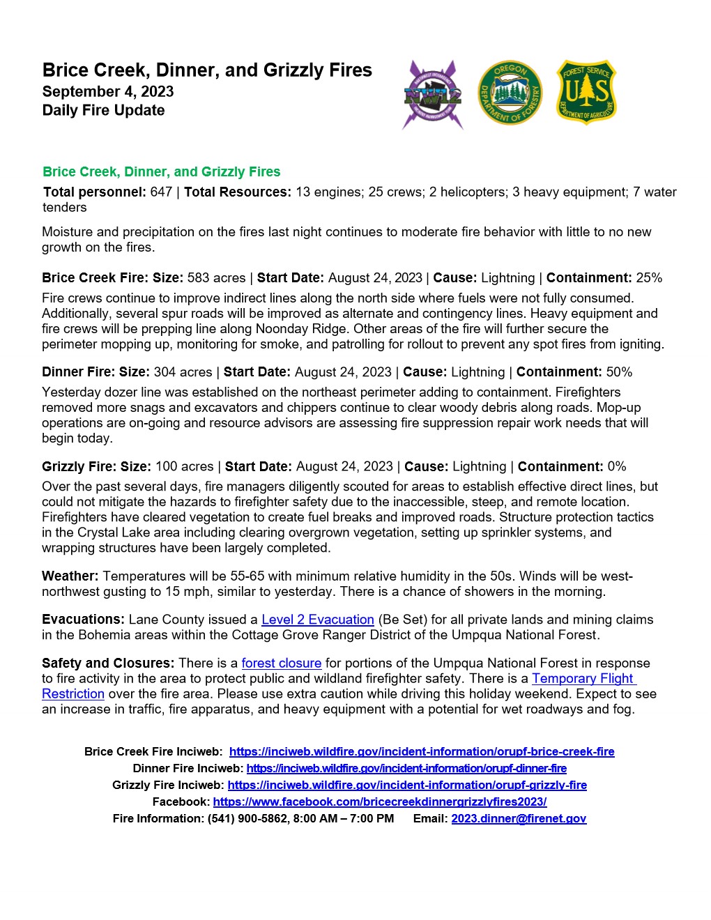
Brice Creek Dinner and Grizzly Fires Daily Update September 4 2023
Related Incident: Brice Creek FireDinner FireGrizzly Fire
Publication Type: News
Brice Creek, Dinner, and Grizzly Fires
September 4, 2023
Daily Fire Update
Brice Creek, Dinner, and Grizzly Fires
Total personnel: 647 | Total Resources: 13 engines; 25 crews; 2 helicopters; 3 heavy equipment; 7 water tenders
Moisture and precipitation on the fires last night continues to moderate fire behavior with little to no new growth on the fires.
Brice Creek Fire: Size: 583 acres | Start Date: August 24, 2023 | Cause: Lightning | Containment: 15%
Fire crews continue to improve indirect lines along the north side where fuels were not fully consumed. Additionally, several spur roads will be improved as alternate and contingency lines. Heavy equipment and fire crews will be prepping line along Noonday Ridge. Other areas of the fire will further secure the perimeter mopping up, monitoring for smoke, and patrolling for rollout to prevent any spot fires from igniting.
Dinner Fire: Size: 304 acres | Start Date: August 24, 2023 | Cause: Lightning | Containment: 50%
Yesterday dozer line was established on the northeast perimeter adding to containment. Firefighters removed more snags and excavators and chippers continue to clear woody debris along roads. Mop-up operations are on-going and resource advisors are assessing fire suppression repair work needs that will begin today.
Grizzly Fire: Size: 100 acres | Start Date: August 24, 2023 | Cause: Lightning | Containment: 0%
Over the past several days, fire managers diligently scouted for areas to establish effective direct lines, but could not mitigate the hazards to firefighter safety due to the inaccessible, steep, and remote location. Firefighters have cleared vegetation to create fuel breaks and improved roads. Structure protection tactics in the Crystal Lake area including clearing overgrown vegetation, setting up sprinkler systems, and wrapping structures have been largely completed.
Weather: Temperatures will be 55-65 with minimum relative humidity in the 50s. Winds will be west-northwest gusting to 15 mph, similar to yesterday. There is a chance of showers in the morning.
Evacuations: Lane County issued a Level 2 Evacuation (Be Set) for all private lands and mining claims in the Bohemia areas within the Cottage Grove Ranger District of the Umpqua National Forest.
Safety and Closures: There is a forest closure for portions of the Umpqua National Forest in response to fire activity in the area to protect public and wildland firefighter safety. There is a Temporary Flight Restriction over the fire area. Please use extra caution while driving this holiday weekend. Expect to see an increase in traffic, fire apparatus, and heavy equipment with a potential for wet roadways and fog.
Brice Creek Fire Inciweb: https://inciweb.wildfire.gov/incident-information/orupf-brice-creek-fire
Dinner Fire Inciweb: https://inciweb.wildfire.gov/incident-information/orupf-dinner-fire
Grizzly Fire Inciweb: https://inciweb.wildfire.gov/incident-information/orupf-grizzly-fire
Facebook: https://www.facebook.com/bricecreekdinnergrizzlyfires2023/
Fire Information: (541) 900-5862, 8:00 AM – 7:00 PM Email: 2023.dinner@firenet.gov