
Brice Creek Dinner and Grizzly Fires Daily Update September 5 2023
Related Incident: Brice Creek FireDinner FireGrizzly Fire
Publication Type: News
Brice Creek, Dinner, and Grizzly Fires
NW IMT12 Branch I
September 5, 2023
Daily Fire Update
Brice Creek, Dinner, and Grizzly Fires
Total personnel: 586 | Total Resources: 11 engines; 21 crews; 2 helicopters; 4 heavy equipment; 7 water tenders
Northwest Incident Management Team 12 assumed command of the Chilcoot and Ridge Fires this morning and will now be managing the Brice Creek, Dinner, and Grizzly Fires as Branch I and the Chilcoot and Ridge Fires as Branch II. There will be a Virtual Community Meeting for the Brice Creek, Dinner, and Grizzly Fires on Thursday, September 7th at 7:30 PM on our Facebook page.
Precipitation over the fires yesterday continues to moderate fire behavior and no new fire growth has been reported.
Brice Creek Fire: Size: 583 acres | Start Date: August 24, 2023 | Cause: Lightning | Containment: 25%
North of the fire, crews and heavy equipment are improving roads as secondary containment lines, connecting Forest Service Road (FSR) 2216 to FSR 951. Chippers are aiding in this by reducing woody fuels along roads. Along the fire’s edge, firefighters are making progress in the rigorous mop-up process extinguishing smoldering in the deep duff layers and heavy dead and downed trees. Unburned pockets of fuel inside the fire perimeter are being patrolled.
Dinner Fire: Size: 304 acres | Start Date: August 24, 2023 | Cause: Lightning | Containment: 60%
Containment on the Dinner Fire steadily increases. Excavators have been working the southwest flank of the fire, removing woody debris off FSR 1745. On the northwest flank of the fire mop up operations are ongoing and no new fire growth is expected.
Grizzly Fire: Size: 100 acres | Start Date: August 24, 2023 | Cause: Lightning | Containment: 0%
The Grizzly Fire has proved challenging for firefighters. Direct access has been difficult due to the rugged terrain. However, rainfall over the last few days has limited fire growth. North of the fire the Noonday Ridge is being utilized as an indirect containment feature and work is progressing. Southwest of the fire, machinery is working off FSR 904. Sprinkler systems and fire-resistant wrapping are being used to protect structures around Crystal Lake and east of Champion Creek.
Weather: Temperatures will range from 65-75 with minimum relative humidity in the range of 35-50%. Winds will be northwest with gusts up to 12 mph.
Evacuations: Lane County issued a Level 2 Evacuation (Be Set) for all private lands and mining claims in the Bohemia areas within the Cottage Grove Ranger District of the Umpqua National Forest.
Safety and Closures: There is a forest closure for portions of the Umpqua National Forest in response to fire activity in the area to protect public and wildland firefighter safety. There is a Temporary Flight Restriction over the fire area.
Brice Creek Fire Inciweb: https://inciweb.wildfire.gov/incident-information/orupf-brice-creek-fire
Dinner Fire Inciweb: https://inciweb.wildfire.gov/incident-information/orupf-dinner-fire
Grizzly Fire Inciweb: https://inciweb.wildfire.gov/incident-information/orupf-grizzly-fire
Facebook: https://www.facebook.com/bricecreekdinnergrizzlyfires2023/
Fire Information: (541) 900-5862, 8:00 AM – 7:00 PM Email: 2023.dinner@firenet.gov
Informacin actualizada para el Incendio Smith River Complex North Martes 5 de Septiembre 2023
Related Incident: Smith River Complex
Publication Type: News
Información actualizada para el Incendio Smith River Complex North, Martes, 5 de Septiembre, 2023
GRANTS PASS, Ore. – El lunes, los manejadores del Incendio advirtieron que a pesar de la lluvia que se ha dado en los cuatro días de media a una pulgada sobre el Incendio Smith River Complex North, este se encuentra lejos de ser extinguido en su totalidad. El Meteorólogo del incidente, Phil Manuel, dijo: “Básicamente las lluvias durmieron al incendio”, pero las condiciones climáticas venideras “traerán al incendio fuera de su hibernación”.
Esta semana, mientras se pueda observar un cielo despejado y el porcentaje de la temperatura se incremente, el material de combustión sobre la superficie se secará más y empezara a quemarse mas activamente. Material de combustión pesado, tales como troncos y ramas, permanecen bien secas, así como los desechos que se encuentran debajo de los árboles y matorrales. Las escuadrillas de bomberos se dedican a preparar la carretera 019 para utilizarla en operaciones de tácticas de quema si es necesario y si las condiciones lo permiten. Otras escuadrillas para la infraestructura y de contingencia, han iniciado el trabajo de remover mangueras y otros equipos de las áreas residenciales en donde ya no son necesarios, sin embargo, algunos equipos de cañería permanecerán en algunos puntos claves.
El lunes, las escuadrillas de bomberos estuvieron trabajando en la extinción de espacios con emanación de calor a lo largo de Monkey Ridge. En el área de Little Sanger, los bomberos transportaron los troncos de los árboles peligrosos que fueron derribados, hacia sitios en donde podrán ser extraídos del área. Se ha completado una línea Este-Oeste a lo largo de la Carretera 450 la cual ha sido extendida hacia abajo en la carretera 305 dirigida hacia la frontera de California. Está progresando la preparación de la línea de Contingencia sobre Chicago Creek hacia Stevens Camp. Con líneas aseguradas alrededor del eje Norte y a lo largo del Hwy. 199, más recursos están siendo movilizados hacia el eje Oeste del incendio. Los camiones de bomberos y astilladoras iniciaron la preparación de la carretera 1107. Además, equipo pesado esta siendo estacionado en el área publica asignada para descanso de Brookings.
El Hwy 199 esta abierto, utilizando un carro piloto que guiara al tráfico a través de unas 8 millas sobre la sección del Highway en donde las barandillas se quemaron y todavía existen otros peligros generados por el incendio. Prepárese para un retraso aproximado de 30 minutos. Para información al día acerca de la condición de carreteras, por favor visite Caltrans site y el Departamento de Transporte en Oregon TripCheck site.
En el Incendio Smith River Complex, las ordenes de cierre para ciertas áreas y carreteras se encuentran en efecto para el Bosque Nacional de Rogue River y para la Agencia para el Manejo de Tierras (BLM) en el Distrito de Coos Bay. Se encuentra en efecto la prohibición de utilizar fogatas en la Wild and Scenic Section de Rogue River. Además, en las tierras de BLM, solamente se autoriza el uso de fogatas en los campamentos designados. Para más información, visite el website del Servicio Forestal: https://bit.ly/RRSNFAlerts y también https://www.blm.gov/orwafire
Un Nivel 2 de Evacuación – LISTOS se encuentra vigente para las áreas de O’Brien y Takilma. Un Nivel 1 de Evacuación – PREPARESE se encuentra en pie al Norte de Cave Junction. La Cruz Roja Americana ha cerrado el centro de albergue en Grants Pass. Por favor monitoree el sitio para Manejo de Emergencias de Rogue Valley y regístrese en el sistema de Información al día para recibir Alertas de Evacuación en: https://rvem.org. También podrá ver un Mapa Interactivo de Respuesta Iniciales de Incendio.
Update Chilcoot and Ridge Fires September 5 2023
Related Incident: 2023 Chilcoot Fire UNF2023 Ridge Fire UNF
Publication Type: News
Chilcoot and Ridge Fires Daily Update
NW IMT12 Branch II
September 5, 2023
Total personnel: 757 | Total Resources: 24 engines; 22 crews; 5 helicopters; 12 heavy equipment; 13 water tenders
Northwest Incident Management Team 12 assumed command of the Chilcoot and Ridge Fires this morning and will now be managing the Brice Creek, Dinner, and Grizzly Fires as Branch I and the Chilcoot and Ridge Fires as Branch II. The team will continue to implement their strategic approach to managing these full-suppression fires with current operational staff, equipment, and aircraft.
There will be a Virtual Community Meeting for the Chilcoot and Ridge Fires on Thursday, September 7th at 7:30 pm on the Chilcoot and Ridge Fires 2023 Facebook page.
Yesterday, firefighters found opportunities to go direct on both fires while also working diligently on handlines and dozer lines. Weekend precipitation resulted in some operations scaling back due to safety concerns and impeded access for firefighting equipment.
Chilcoot Fire: Size: 1,762 acres | Start Date: August 24, 2023 | Cause: Lightning | Containment: 4%
Days of hard work by firefighters contributed to some containment along the fire’s west flank adjacent to private timber lands. Mop up on the northwest corner was hampered by the side effects of this weekend’s rain. Firefighters are going direct while also deploying water pumps and hoses on the northeast corner near the 3809 Road to assist with mop up operations. Dozers are supporting that work while also tying into handline along the south flank. Chipping and mastication have begun across the fire’s entire perimeter except along sections of the north flank.
Ridge Fire: Size: 238 acres | Start Date: August 25, 2023 | Cause: Lightning | Containment: 72%
Increases in containment have been made possible by the continued minimal fire behavior. The entire fire perimeter remains in a smoldering and creeping state. Resources are being gradually transferred to the Chilcoot fire while remaining firefighters mop up and patrol the fire’s perimeter.
Safety and Closures: There is a forest closure for portions of the Umpqua National Forest in response to fire activity in the area to protect public and wildland firefighter safety. A Closure Order for the Canton Creek area has been issued by Bureau of Land Management (BLM): Chilcoot Ridge Fire Emergency Closure Order BLM Roseburg District. There is a Temporary Flight Restriction over the fire area.
Chilcoot Fire InciWeb: https://inciweb.wildfire.gov/incident-information/orupf-2023-chilcoot-fire-unf
Ridge Fire InciWeb: https://inciweb.wildfire.gov/incident-information/orupf-2023-ridge-fire-unf
Chilcoot and Ridge Fires Facebook: https://www.facebook.com/61550481586772
Fire Information: (541) 900-5862, 8:00 AM – 7:00 PM Email: 2023.chilcoot@firenet.gov
Deep Fire Update September 5 2023
Related Incident: Deep Fire
Publication Type: News
Deep Fire Update
September 5, 2023 7:00am
Fire information: 530/638-2830 (8:00 a.m. to 8:00 p.m.)
Inciweb: https://inciweb.nwcg.gov/incident-information/cashf-deep-fire
Deep Fire Facebook: https://www.facebook.com/DeepFire2023
CURRENT SITUATION
The Deep Fire is expected to have moderate burning conditions today and is currently mapped at 4,198 acres with 60% total containment.
Hitting hot spots on the northern and eastern flank of the fire remains a focus for crews. Crews continue to take a direct approach on the fireline. Today crews will be removing hose from the southern edges and securing the line in Little Salt Creek. The southeastern edge of the burn area is secure. Crews spiked out at Morris Meadow are improving the line along the upper Stuart Fork Trail. Due to safety concerns the trail is closed to the public. The hazards of log rollout, fire weakened trees and bees remain safety concerns for crews.
The fire is smoldering and creeping with low flame lengths. Bits of smoke may show up as the cloud cover clears out. Packers and their mules are key support to meet operational objectives in the wilderness.
Roads and trails are being repaired with resource advisors assisting to protect values at risk. Minimum impact suppression techniques are being utilized in addition to Leave No Trace principles being employed in the wilderness.
WEATHER
Low clouds are expected in the morning with light winds. Temperatures are expected to rise over the next few days toward the 60s and 70s as part of a warming and drying trend.
FOREST CLOSURES
There is a forest closure associated with the Deep Fire. For current information on forest closures, visit https://www.fs.usda.gov/stnf
EVACUATION UPDATES
For the latest evacuation information from the Trinity County Sheriff’s Department:https://www.facebook.com/people/Trinity-County-Sheriffs-Office/100064589806351/
For information on evacuation resources from the Trinity County Office of Emergency Services:https://www.trinitycounty.org/OES
To sign up for codeRED notifications: text “TrinityCA” to 99411.
Happy Camp Complex Incident Update September 5 2023 Morning
Related Incident: 2023 Happy Camp Complex Klamath NF
Publication Type: News
VIRTUAL PUBLIC MEETING RESCHEDULED: The virtual public meeting previously scheduled for September 5th will now be held on Wednesday, September 6th, at 5:30 p.m. Fire personnel will provide an operational overview of the fire situation. The meeting will be live-streamed on Facebook (facebook.com/KlamathNF) and YouTube (youtube.com/@ciimt5). A Facebook account is not necessary to view the meeting.
WEATHER: Warmer and drier weather with low humidities will continue today. As temperatures and fire activity increase this week, prevailing winds may bring smoke back into some areas.
WEST SIDE OVERVIEW (ACRES/CONTAINMENT): Elliot (12,107 acres, 51%), Ufish (5,056 acres, 33%), Hancock (1,720 acres, 0%)
Last night, firefighters on the Elliot and Ufish fires patrolled along State Route 96 and reported minimal fire activity. Today, crews on the Elliot Fire will work on the west side of the fire to continue improving fire line and assessing options for connecting the fire line to Dillon Creek. If conditions are favorable, firefighters on the Ufish Fire will conduct strategic firing operations to hold the fire east of State Route 96. More resources will be flown into the Hancock Fire today. Crews will begin to work on the east side of the fire with the mission of developing tactics that support the overall strategy.
EAST SIDE OVERVIEW (ACRES/CONTAINMENT): Head (6,940 acres, 91%), Block (0.1 acres, 100%), Townsend (81 acres, 100%), Den (294 acres, 100%), Scott (1,886 acres, 100%), Lake (199, acres, 100%)
Minimal fire activity was observed on the Head, Scott, and Lake fires last night. Suppression repair will continue today on the Head Fire. Firefighters will work to secure fire lines on the west side of the fire where they continue to find small pockets of heat near open line. The Scott Fire will be patrolled by crews and equipment no longer needed on the fire line is being removed and will be redeployed to other fires on the complex. The extraction of crews from the Lake Fire will begin today. The fire is 100% contained and mop up has been completed. The Lake Fire will be patrolled by air after firefighters have left the area.
EVACUATIONS: View current Siskiyou County evacuation orders and warnings by visiting: https://community.zonehaven.com. Siskiyou County residents are encouraged to sign up for rapid emergency notifications using the CodeRED emergency alert system at: www.co.siskiyou.ca.us/emergencyservices/page/codered-emergency-alert
ROAD CONDITIONS: No road work will be performed on State Route 96 through Wednesday, September 6th, at 7 a.m., to allow for holiday travel. Please keep in mind that one-way traffic control will remain in place from 2.8 miles west of Dillon Road to 8.8 miles east of Dillion Road, as this remains in an active fire area for the Elliot Fire. Motorists can expect up to 30-minute delays in this area. County road closures will be listed on the Siskiyou County Public Works website: www.co.siskiyou.ca.us/publicworks/page/closures-and-delays
FOREST CLOSURES: Two closure orders have been implemented: Happy Camp Complex Emergency Fire Closure No. 05-05-23-06 and No. 05-05-23-08. Additionally, fire restrictions remain in place to help minimize the chances of human-caused wildland fires. These restrictions prohibit campfires outside of designated improved recreation areas and wilderness. View closure orders, fire restrictions, and maps at: www.fs.usda.gov/alerts/klamath/alerts-notices
TEMPORARY FLIGHT RESTRICTION (TFR): A TFR has been established over the fire area. Flight restrictions include the use of drones. The operation of drones under the TFR is prohibited.
PACIFIC CREST TRAIL: The Pacific Crest Trail is now open between the Shelly Fork Junction and Seiad.
AIR QUALITY: For information regarding smoke impacts and what you can do to protect yourself, visit the Siskiyou County Air Pollution Control District Fire and Smoke Information website at: www.co.siskiyou.ca.us/airpollution/page/fire-and-smoke-information or AirNow.gov
Perspectiva de Humo Smith River Complex North 905 906
Related Incident: Smith River Complex
Publication Type: News
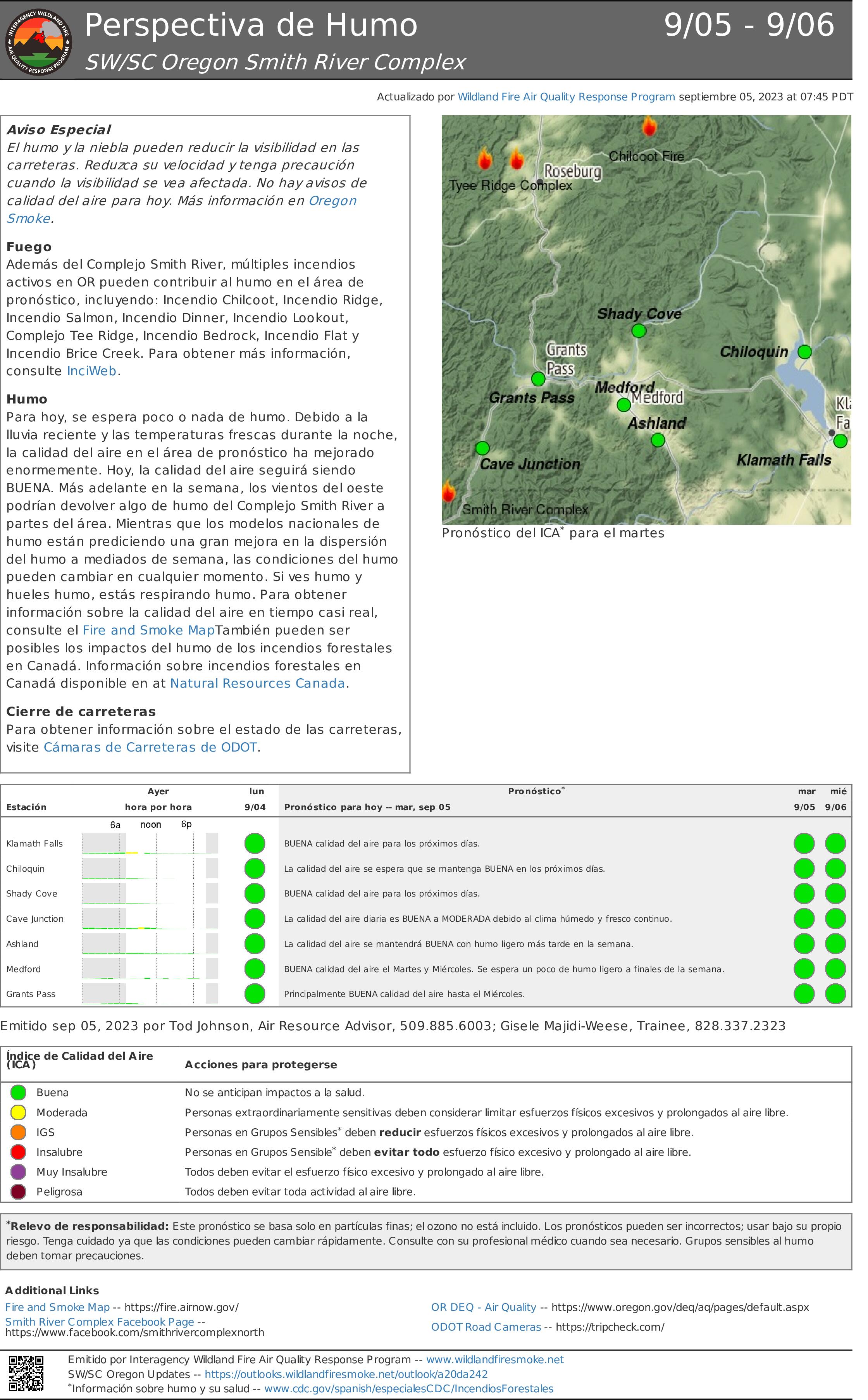
Aviso Especial
El humo y la niebla pueden reducir la visibilidad en las carreteras. Reduzca su velocidad y tenga precaución cuando la visibilidad se vea afectada. No hay avisos de calidad del aire para hoy. Más información en Oregon Smoke.
Fuego
Además del Complejo Smith River, múltiples incendios activos en Oregon pueden contribuir al humo en el área de pronóstico, incluyendo: Incendio Chilcoot, Incendio Ridge, Incendio Salmon, Incendio Dinner, Incendio Lookout, Complejo Tee Ridge, Incendio Bedrock, Incendio Flat y Incendio Brice Creek. Para obtener más información, consulte InciWeb.
Humo
Para hoy, se espera poco o nada de humo. Debido a la lluvia reciente y las temperaturas frescas durante la noche, la calidad del aire en el área de pronóstico ha mejorado enormemente. Hoy, la calidad del aire seguirá siendo BUENA. Más adelante en la semana, los vientos del oeste podrían devolver algo de humo del Complejo Smith River a partes del área. Mientras que los modelos nacionales de humo están prediciendo una gran mejora en la dispersión del humo a mediados de semana, las condiciones del humo pueden cambiar en cualquier momento. Si ves humo y hueles humo, estás respirando humo. Para obtener información sobre la calidad del aire en tiempo casi real,
consulte el Fire and Smoke MapTambién pueden ser posibles los impactos del humo de los incendios forestales en Canadá. Información sobre incendios forestales en Canadá disponible en at Natural Resources Canada.
Cierre de carreteras
Para obtener información sobre el estado de las carreteras, visite Cámaras de Carreteras de Oregon Department of Transportation.
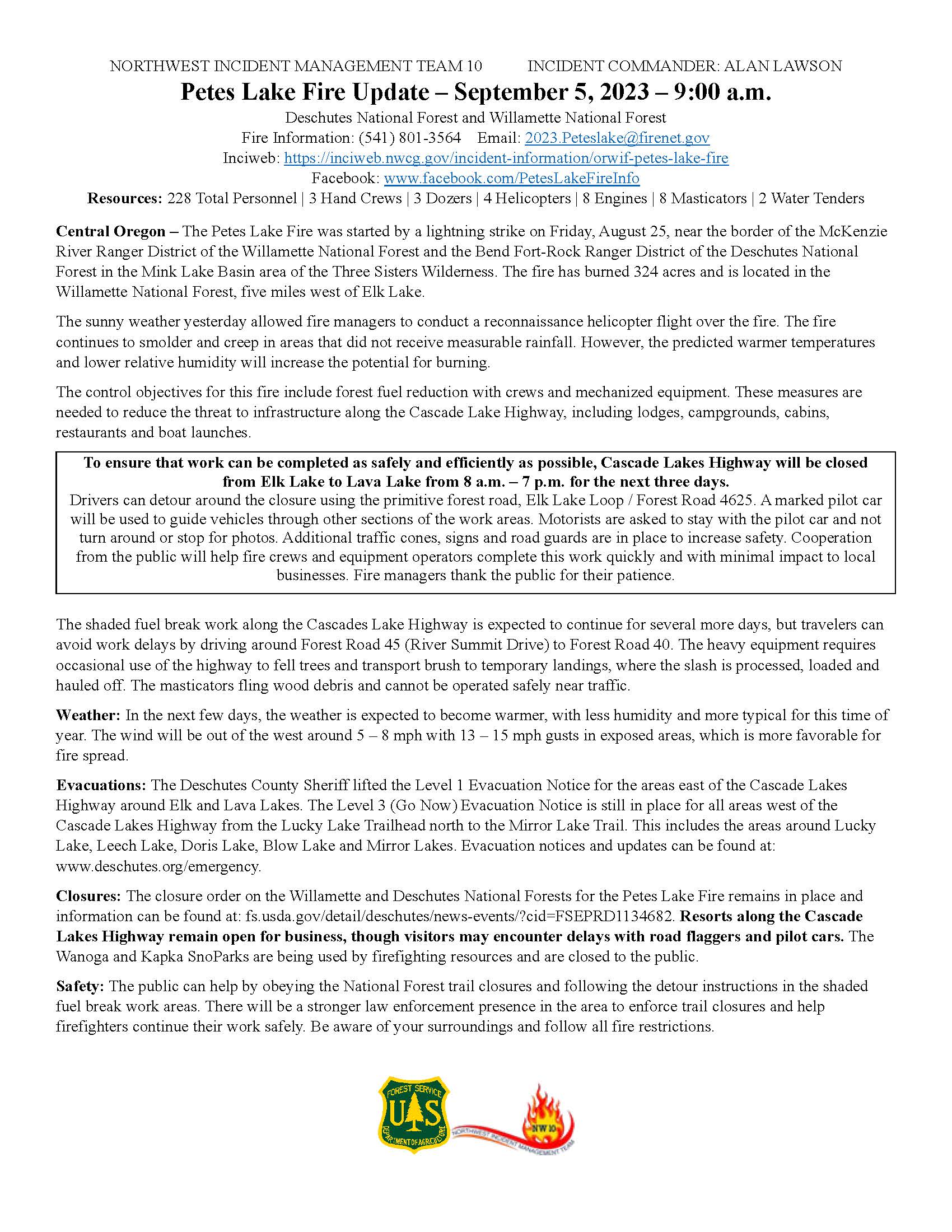
Petes Lake Fire Update September 5 2023
Related Incident: Petes Lake Fire
Publication Type: News
Resources: 228 Total Personnel | 3 Hand Crews | 3 Dozers | 4 Helicopters | 8 Engines | 8 Masticators | 2 Water Tenders
Central Oregon – The Petes Lake Fire was started by a lightning strike on Friday, August 25, near the border of the McKenzie River Ranger District of the Willamette National Forest and the Bend Fort-Rock Ranger District of the Deschutes National Forest in the Mink Lake Basin area of the Three Sisters Wilderness. The fire has burned 324 acres and is located in the Willamette National Forest, five miles west of Elk Lake.
The sunny weather yesterday allowed fire managers to conduct a reconnaissance helicopter flight over the fire. The fire continues to smolder and creep in areas that did not receive measurable rainfall. However, the predicted warmer temperatures and lower relative humidity will increase the potential for burning.
The control objectives for this fire include forest fuel reduction with crews and mechanized equipment. These measures are needed to reduce the threat to infrastructure along the Cascade Lake Highway, including lodges, campgrounds, cabins, restaurants and boat launches.
To ensure that work can be completed as safely and efficiently as possible, Cascade Lakes Highway will be closed from Elk Lake to Lava Lake from 8 a.m. – 7 p.m. for the next three days.
Drivers can detour around the closure using the primitive forest road, Elk Lake Loop / Forest Road 4625. A marked pilot car will be used to guide vehicles through other sections of the work areas. Motorists are asked to stay with the pilot car and not turn around or stop for photos. Additional traffic cones, signs and road guards are in place to increase safety. Cooperation from the public will help fire crews and equipment operators complete this work quickly and with minimal impact to local businesses. Fire managers thank the public for their patience.
The shaded fuel break work along the Cascades Lake Highway is expected to continue for several more days, but travelers can avoid work delays by driving around Forest Road 45 (River Summit Drive) to Forest Road 40. The heavy equipment requires occasional use of the highway to fell trees and transport brush to temporary landings, where the slash is processed, loaded and hauled off. The masticators fling wood debris and cannot be operated safely near traffic.
Weather: In the next few days, the weather is expected to become warmer, with less humidity and more typical for this time of year. The wind will be out of the west around 5 – 8 mph with 13 – 15 mph gusts in exposed areas, which is more favorable for fire spread.
Evacuations: The Deschutes County Sheriff lifted the Level 1 Evacuation Notice for the areas east of the Cascade Lakes Highway around Elk and Lava Lakes. The Level 3 (Go Now) Evacuation Notice is still in place for all areas west of the Cascade Lakes Highway from the Lucky Lake Trailhead north to the Mirror Lake Trail. This includes the areas around Lucky Lake, Leech Lake, Doris Lake, Blow Lake and Mirror Lakes. Evacuation notices and updates can be found at: www.deschutes.org/emergency.
Closures: The closure order on the Willamette and Deschutes National Forests for the Petes Lake Fire remains in place and information can be found at: fs.usda.gov/detail/deschutes/news-events/?cid=FSEPRD1134682. Resorts along the Cascade Lakes Highway remain open for business, though visitors may encounter delays with road flaggers and pilot cars. The Wanoga and Kapka SnoParks are being used by firefighting resources and are closed to the public.
Safety: The public can help by obeying the National Forest trail closures and following the detour instructions in the shaded fuel break work areas. There will be a stronger law enforcement presence in the area to enforce trail closures and help firefighters continue their work safely. Be aware of your surroundings and follow all fire restrictions.
Smoke Outlook 95 96 Smith River Complex
Related Incident: Smith River Complex
Publication Type: News
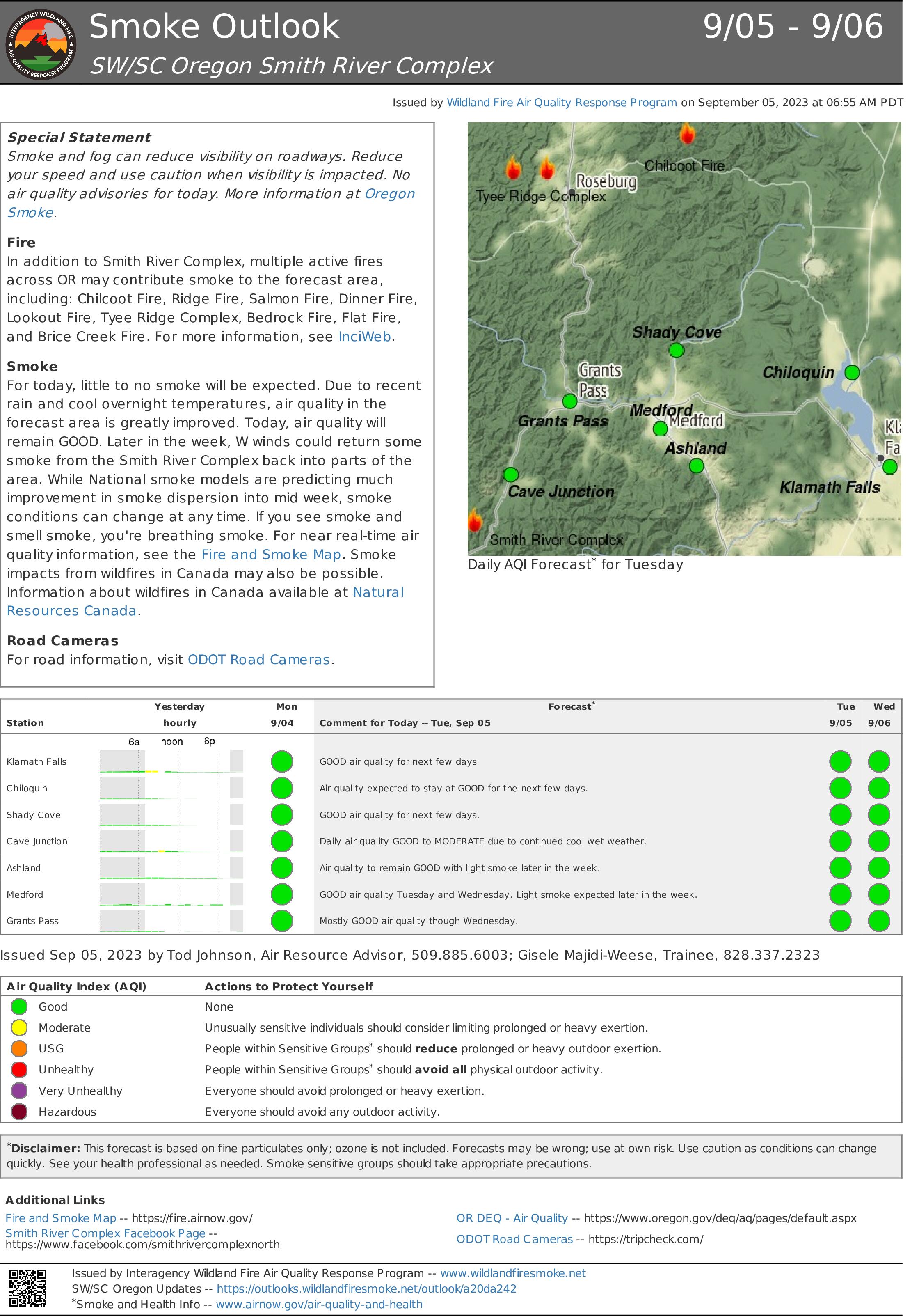
Special Statement
Smoke and fog can reduce visibility on roadways. Reduce your speed and use caution when visibility is impacted. No air quality advisories for today. More information at Oregon Smoke.
Fire
In addition to Smith River Complex, multiple active fires across OR may contribute smoke to the forecast area, including: Chilcoot Fire, Ridge Fire, Salmon Fire, Dinner Fire, Lookout Fire, Tyee Ridge Complex, Bedrock Fire, Flat Fire, and Brice Creek Fire. For more information, see InciWeb.
Smoke
For today, little to no smoke will be expected. Due to recent rain and cool overnight temperatures, air quality in the forecast area is greatly improved. Today, air quality will remain GOOD. Later in the week, W winds could return some smoke from the Smith River Complex back into parts of the area. While National smoke models are predicting much improvement in smoke dispersion into mid week, smoke conditions can change at any time. If you see smoke and smell smoke, you're breathing smoke. For near real-time air quality information, see the Fire and Smoke Map. Smoke impacts from wildfires in Canada may also be possible. Information about wildfires in Canada available at Natural
Resources Canada.
Road Cameras
For road information, visit ODOT Road Cameras.
Oregon Fire Update 5 September 2023
Related Incident: Oregon Fire
Publication Type: Announcement
Fire Size: 10,817 acres
Initial Start: 8/18/2023 at 1600 pm
Location: Approximately 4 miles northeast of Elk, WA.
Cause: Human
Containment: 90%
Resources Committed: 18 Engines, 4 Crews, 1 Bulldozer, 6 Water Tenders, 2 Skidgens
Personnel: 213
Damage Assessment: 126 primary homes and 258 outbuildings destroyed.
Road Closures: None
Elk, WA, - Current Situation: Northeast WA Incident Management Team 3 is in command of the Oregon and Gray fires. The Oregon Fire continues to remain within the current footprint with no further growth, the strategy remains full suppression and work is progressing as expected. Northeast WA Incident Management Team 3 will continue their efforts with local resources through next week.
Today’s activities: Mop-up, patrol and suppression repair will continue across all divisions of the fire. Handheld Infrared will be utilized to survey the fire area to continue to seek out remaining sources of heat. More resources are planned to be released today as the team continuously works to right size the incident.
Evacuations: All evacuations throughout the entire fire area have been rescinded.
Weather: A subtle warming and drying trend will begin on Tuesday and continue through the week. Look for mid and high-level clouds passing through in the morning giving way to fair afternoon cumulus. Winds will be light and variable in the early morning with speeds generally under 10mph. the drying of the airmass will equate to cooler morning lows in the 40’s while highs rebound in the 70’s.
For fire information contact the Public Information Officer at 509-508-3323 or email 2023.oregon@firenet.gov
Bosque Nacional Seis Ros Complejo del Ro Smith Sur Martes Septiember 5 2023
Related Incident: Smith River Complex
Publication Type: News
Acres: 85,501
Contención: 19 %
Causa: Relámpagos
Fecha de inicio: 15 de Agosto
Recursos: 57 tripulaciones, 171 camiones de bomberos , 10 helicópteros, 4 drones, 18 topadoras, 16 masticadores,6 minicargadoras, 37 embarcaciones
Personal: 2,528
Situación actual: Los bomberos en una misión de reconocimiento aéreo el lunes observaron humo mínimo y puntos calientes en el lado oeste del incendio Kelly desde la frontera estatal sur hasta Gasquet. La parte sur del incendio tenía áreas de calor dispersas. En el perímetro este del incendio, al sur de la estación de mantenimiento Caltrans Idlewild, la mayor parte del calor se limitó a una viga de madera ardiendo donde el fuego avanza cuesta abajo hasta el río Siskiyou.
Varios días de actividad mínima del incendio han permitido a los equipos perfeccionar un plan de extinción total que implica el uso de tácticas de extinción tanto directas como indirectas. Cuando sea seguro hacerlo, las cuadrillas han estado y continuarán extinguiendo los puntos críticos directamente en el borde del incendio. En otros lugares, deben confiar en una estrategia de extinción indirecta, que implica el uso de topadoras, líneas de mano, caminos, ríos y otras características naturales para contener el fuego. Las cuadrillas han estado identificando y preparando esas características de contención, que están lo más cerca posible del incendio, masticando maleza, instalando mangueras y bombas, y ampliando caminos y cortafuegos. Según lo permitan las condiciones climáticas, realizarán operaciones de disparo desde los elementos de contención hacia el incendio principal. Esta estrategia de supresión indirecta es necesaria debido al terreno inseguro, extremadamente empinado y accidentado y a los largos tiempos que se requieren para transportar al personal durante las emergencias.
Clima y comportamiento del incendio: El clima seco y ventoso continuará durante la semana. Es posible que se hagan evidentes nuevos incendios debido a los rayos del fin de semana pasado. El incidente cuenta con un equipo de ataque inicial que puede responder rápidamente a nuevos incendios. No se espera un crecimiento significativo del incendio en ningún incendio en el Smith River Complex South el martes.
Humo y calidad del aire: Se esperan niveles bajos de humo hasta que comiencen las operaciones de incendio a finales de esta semana. Una perspectiva de humo diaria que incluye información sobre la calidad del aire está disponible aquí: tinyurl.com/2ya8z42f.
Cierres: US-199 ahora está ABIERTA a todo el tráfico. Sin embargo, un segmento de 11 millas, actualmente entre Sandy Beach (cerca de la milla 21) y Oregon Mountain Road (cerca de la milla 31), tiene control de tráfico pilotado unidireccional. Es posible que haya retrasos de hasta 45 minutos. El segmento pilotado se expandirá o contraerá a medida que las cuadrillas reparen las barandillas quemadas, retiren las rocas de la carretera y eliminen los árboles peligrosos.
Los terrenos, caminos y senderos del Bosque Nacional Six Rivers que rodean el Complejo están cerrados (Orden Forestal No. 10-23-06). El mapa de orden y cierre se puede ver en esta página web del Bosque Nacional Six River: tinyurl.com/4atens8c.
Evacuaciones: Evacuaciones: Las órdenes de evacuación emitidas por la Oficina del Sheriff del Condado de Del Norte siguen vigentes. Vea el mapa de evacuación interactivo en línea para conocer las evacuaciones más recientes: tinyurl.com/yp3d99sr.
· NIVEL 3, GO/ Vaya ahora: Rockland
· NIVEL 2, Get Set/ Prepárese: Rowdy Creek/Low Divide, Gasquet, Big Flat/Rock Creek, Patricks Creek Lodge, Little Jones/Washington Flat Residential Areas, Oregon Mountain Road Area, Sun Star
· NIVEL 1, Get Ready/ Esté preparado: Hiouchi
Información sobre incendios:
Email: 2023.SmithRiverComplex@firenet.gov (South and North)
Phones: 707-383-9727 (South), 541-801-3495 (North)
Facebook: facebook.com/SixRiversNF